.
For more frequent updates check out the weather Facebook page - click here and hit like at the top of the page.
.
This page is best viewed with Mozilla Firefox. There could be issues with spacing on Internet Explorer
.

.
This forecast covers far southern Illinois, southeast Missouri, southwest Indiana, western Kentucky, and northwest Tennessee - for your local town/area - click here
.
Here are my current personal forecast thoughts for far southern Illinois and western Kentucky...
.
Friday night: Some clouds early - then mostly clear and cold. A few patches of fog possible.
Lows: in the upper teens to lower 20s | Normal lows for this time of the year are around 30 degrees.Below normal temperatures
Wind: North winds at 5 mph.
Precipitation probability - 0% | Rainfall totals: 0"
Confidence in this forecast is very high
.
Saturday: Mostly sunny skies - cold with well below normal temperatures
Below normal temperatures.
Highs: around 36 degrees. | Normal highs for this time of the year are around 48 degrees.Below normal temperatures.
Wind: Northeast winds at 10 mph
Precipitation probability - 0% | Rainfall totals: 0"
Confidence in this forecast is very high
.
Saturday night: Mostly clear and cold
Below normal temperatures
Below normal temperatures
Lows: in the upper teens to lower 20s | Normal lows for this time of the year are around 30 degrees.
Wind: Calm winds
Precipitation probability - 0% | Rainfall totals: 0"
Confidence in this forecast is very high
Wind: Calm winds
Precipitation probability - 0% | Rainfall totals: 0"
Confidence in this forecast is very high
.
Sunday: Mostly sunny skies.
Below normal temperatures.
Highs: around 44 degrees | Normal highs for this time of the year are around 48 degrees.Wind: West winds at 5-15 mph
Precipitation probability - 0% | Rainfall totals: 0"
Confidence in this forecast is very high
.
.
Don't forget to sign up for the severe weather "heads up" email list - I usually email everyone before a big event - severe weather or winter storms - ice storms. Click here to join
.

.


Forecast for your local town/city - Click Here
.
..
Join me on Facebook for more frequent updates on the weather in our local areaClick Here.
.
---

The forecast for severe or extreme weather for the next 24 hours
.
The McCracken County Office of Emergency Management reminds you that owning a NOAA All Hazards Weather Radio is the best way to receive notifications of severe weather watches and warnings.
.
Remember that the National Weather Service defines a severe thunderstorm as one that produces 58 mph winds or higher, hail 1" in size or larger, and/or a tornado. More information with some slides concerning reporting severe weather - click here
.
For the most up to date severe weather outlooks - click here.
or
Visit the Storm Prediction Center's web-site - click here
.
Friday night: Severe weather is not anticipated. No snow or ice.
Friday night: Will there be a chance for non-severe thunderstorms? No
.
.
Friday night: Severe weather is not anticipated. No snow or ice.
Friday night: Will there be a chance for non-severe thunderstorms? No
.
Saturday: Severe weather is not anticipated. No snow or ice.
Saturday: Will there be a chance for non-severe thunderstorms? No
.Saturday: Will there be a chance for non-severe thunderstorms? No
Saturday night : Severe weather is not anticipated. No snow or ice.
Saturday night: Will there be a chance for non-severe thunderstorms? No
.
Sunday: Severe weather is not anticipated. No snow or ice.
Sunday: Will there be a risk for non-severe thunderstorms? No
.
Sunday: Will there be a risk for non-severe thunderstorms? No
.

.
To view all watches and warnings in IL - Click Here
To view all watches and warnings in KY - Click Here
To view all watches and warnings in MO - Click Here
To view all watches and warnings in TN - Click Here
All other states- Click Here
To view all watches and warnings in IL - Click Here
To view all watches and warnings in KY - Click Here
To view all watches and warnings in MO - Click Here
To view all watches and warnings in TN - Click Here
All other states- Click Here
.
The links above are interactive and you can move around the United States by simply clicking on the national map - or from the pull down menu where it says regions and US States.
.
To view the interactive map - click here.
.
To view the interactive map - click here.
.
.

.
.
HEADLINE: Cold weather for the next few days with below to well below normal temperatures. Lows tonight and Saturday night will be in the 18-24 degree range over our region. This cold air mass will slowly modify on Sunday and will modify a bit more next week ahead of our next rain producer.
.
The plumes tonight show temps mostly in that range, as well - the plumes are a variety of model runs that give forecasters a better idea of what the range might be - then the forecaster has to decide which number is most likely to be correct. Click for real view size.
.
The medium point on these plumes (for tonight - Friday night) seem to be in the lower to middle 20s - a few of them point to teens. I suspect we will see a range in our counties - warmer in the urban areas (typical) and colder in some of the favored cold spots.
.

.
Rain will develop on Wednesday into Thursday - some of the data stalls the front out over the region. If this is true then we may have several rainy days ahead of us. Rain we do not need. Right now another widespread 0.50-1.00" of rain is expected with this first wave on Wednesday.
.
I ran some analog analysis on next week storm - they show a decent shot at 0.50" of rain up to 1" - they did not indicate a significant risk of 2" or more of rain - however, the one potential concern is that the boundary stalls out later next week and returns to our local area - this would bring additional rains perhaps around next weekend - and/or frozen precipitation.
.
Additional rainfall is possible into next weekend.
.
A VERY active weather pattern appears to be developing for the last half of the month. Data is showing several interesting events for meteorologists to monitor. Perhaps we will finally see our first widespread snow event? Appears possible - see the long range discussion below.
.
Rivers will be on the rise - see the latest lake and river stage forecasts - here.
.
We have a TON of new weather maps on the Weather Observatory web-site - these include temperatures, wind speed, dew points, heat index, barometric pressure, predicted rainfall, climate forecast, medium and long range maps, forecasts and more! Click here
.
.
-----------------------------
.

.
Let's check out the how much rain is forecast to fall over the next 24 hours. This map gives you a general broad brushed idea of what can be expected. Remember the scale is at the top of the map.
.
If you would like to view the most up to date 24, 48, 72, and 120 hour precipitation forecast maps then click here.
.
If you would like to view the most up to date 24, 48, 72, and 120 hour precipitation forecast maps then click here.
.

.

.
You can also now view the probability of X amount of rain (you pick the value on the web-site) in a six hour period of time. Those maps can be viewed here.
.
You can view drought maps on the Weather Observatory web-site by clicking here.
.

You can also now view the probability of X amount of rain (you pick the value on the web-site) in a six hour period of time. Those maps can be viewed here.
.
You can view drought maps on the Weather Observatory web-site by clicking here.
.
.
. Sorry snow fans - no snow in our forecast for the next few days.
. Sorry snow fans - no snow in our forecast for the next few days.
.
Enhanced snowfall interactive forecast maps . You can choose your total snowfall amounts above the map - time frame, as well- click here
.
Snowfall forecast maps - these are interactive maps. You can choose your total snowfall amounts above the map - time frame, as well - click here
Enhanced snowfall interactive forecast maps . You can choose your total snowfall amounts above the map - time frame, as well- click here
.
Snowfall forecast maps - these are interactive maps. You can choose your total snowfall amounts above the map - time frame, as well - click here
.
If you are looking for wintry precipitation - click here.
.
.

.
You can view the upcoming days high temperature and low temperature forecasts by clicking here - choose the day - click on your state to zoom in
You can view the upcoming days high temperature and low temperature forecasts by clicking here - choose the day - click on your state to zoom in
.
 .
. We have a number of new radars available on our Weather Observatory web-site!
---
We now offer St Louis, Mt Vernon, Evansville, Poplar Bluff, Cape Girardeau, Marion, Paducah, Hopkinsville, and Dyersburg Interactive City Radars. We also have the two regional radars and now offer you three GR Earth radars.
http://www.weatherobservatory.com/weather-radar.htm---
---
We also have a new interactive radar - you can view that radar by clicking here.
.
Want to learn more about how to use our radars? I made a how to video with more information
Click here - http://www.youtube.com/watch?v=bfLa0hI3adU
.
.
.
.
---

.
.
Date Range: December 1st - December 11th
Event: Mostly below normal to much below normal temperatures. Active pattern.
Severe Risk: Not expecting severe weather.
Frozen Precipitation Risk:
Details: Cold air - several shots of below normal temperatures.
Confidence in my forecast: Very high
.
Date Range: December 11th - December 18th
Event: Swings in temperatures.
Severe Risk:
Frozen Precipitation Risk: One or two precipitation events possible - watching the 14th-16th time period for one event - right now data is showing a rain event. Locally heavy rain will be possible.
Details: Transition period with swings from above to below normal temperatures. A chance for one or two precipitation events, Locally heavy rain again possible.
Confidence in my forecast. Very High
.
.
Date Range: December 19th - December 23rd
Event: Precipitation event - significant storm system possible.
Severe Risk: Unknown
Frozen Precipitation Risk: Unknown
Details: A more significant storm system possible in or near our region. Followed by another large blast of cold air.
Confidence in my forecast. Low
.
.
Date Range: December 24th-29th
Event: Significant storm system in the Missouri/Ohio/Tennessee Valley
Severe Risk:
Frozen Precipitation Risk:
Details: Potential precipitation event.
Confidence in my forecast: Low
.
.
Remember that as a general policy, in the long range outlook, I will NOT mention severe thunderstorms more than 72 hours in advance. I will mention thunderstorm risks and I will give as many details as possible. The word severe will be reserved for the short range forecast.
.
-----------------------------
.
1. The long range forecast is active - multiple storm systems to watch between now and the end of the month - perhaps as many as four or five systems! Meteorologists will be kept busy in the coming weeks.
.
The best shot at rain in the long range will arrive on Wednesday/Thursday then perhaps rain or a mixture of precipitation again next weekend - there is uncertainty on that particular storm. Several systems after that, as well. Busy times for the weather department.
.
The big question will be whether or not we can pick up one or two winter storms out of this pattern. Temperature profiles and storm tracks will be close. Right now a lot of the data is indicating quite a bit of rain between now and Christmas - with perhaps a chance for rain ending as snow. But - of course this is the long range and we all know how tricky snow forecasting can be beyond a day or two.
.
We will continue to monitor each storm - add to the above long range forecasts and tweak as needed.
.
If you want to GO BIG then you want to be near the sharp temperature contrast zone on the weather map. Check out these images from the long range GFS - GFS is a model. One of many models that we use to forecast the weather. Keep in mind that the further you go out in "model-land" the less accurate the model is likely to be.
.
We are looking at LONG range maps here - but you get the general idea. It would not surprise me at all - looking at the upcoming pattern - that we end up near the cold - warm boundary. THIS is where the action occurs. The question on your mind and everyone's mind is does this mean snow or rain - or both!
.
My guess is a little bit of both - next weeks system looks wet. Then after that we might be closer to some frozen precipitation. According to the GFS it is razor thin - very cold air near our region - warm air near our region.
.
One thing is almost certain - it is not going to be boring.
.
Here is what the GFS model is forecasting for temperatures (picked some dates scattered throughout the coming weeks) - again what I want you to see in these images are the sharp contrasts between the cold and warm air - THE BATTLE ground region. You see that many times we end up just warm enough for rain. In order for some of the precipitation events to turn out snow - we need to move that boundary south a bit.
.
Will snow bunnies be heartbroken with lots of rain? Will they rejoice with buckets of white gold? Time will tell.
.
All images are from my favorite model data source www.wright-weather.com
.
Click images for REAL view size
.

.


.


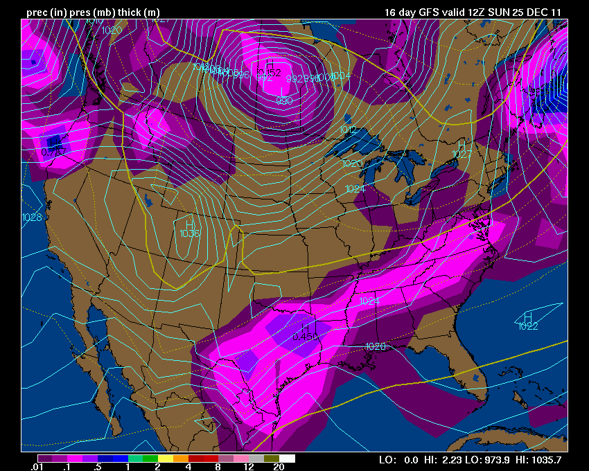
AND I promised you we would take a look at Christmas Eve and Christmas Day - again GFS
.
Here is what the GFS is showing - again this is a LONG LONG way off - I call this fantasy land for models because their accuracy beyond day 4 or 5 is very low. Let's monitor it each day or two and see where it goes. Again maps are from Wright-Weather and click the image for full view size.
.
 .
.
Check back in again tomorrow - let's see how it has changed. We will ride this roller-coaster together! This time the GFS is showing precipitation both days - looks a bit warm. This particular run could be rain changing to snow. At least there is a storm to watch - keep hope alive!
.


.
The best shot at rain in the long range will arrive on Wednesday/Thursday then perhaps rain or a mixture of precipitation again next weekend - there is uncertainty on that particular storm. Several systems after that, as well. Busy times for the weather department.
.
The big question will be whether or not we can pick up one or two winter storms out of this pattern. Temperature profiles and storm tracks will be close. Right now a lot of the data is indicating quite a bit of rain between now and Christmas - with perhaps a chance for rain ending as snow. But - of course this is the long range and we all know how tricky snow forecasting can be beyond a day or two.
.
We will continue to monitor each storm - add to the above long range forecasts and tweak as needed.
.
If you want to GO BIG then you want to be near the sharp temperature contrast zone on the weather map. Check out these images from the long range GFS - GFS is a model. One of many models that we use to forecast the weather. Keep in mind that the further you go out in "model-land" the less accurate the model is likely to be.
.
We are looking at LONG range maps here - but you get the general idea. It would not surprise me at all - looking at the upcoming pattern - that we end up near the cold - warm boundary. THIS is where the action occurs. The question on your mind and everyone's mind is does this mean snow or rain - or both!
.
My guess is a little bit of both - next weeks system looks wet. Then after that we might be closer to some frozen precipitation. According to the GFS it is razor thin - very cold air near our region - warm air near our region.
.
One thing is almost certain - it is not going to be boring.
.
Here is what the GFS model is forecasting for temperatures (picked some dates scattered throughout the coming weeks) - again what I want you to see in these images are the sharp contrasts between the cold and warm air - THE BATTLE ground region. You see that many times we end up just warm enough for rain. In order for some of the precipitation events to turn out snow - we need to move that boundary south a bit.
.
Will snow bunnies be heartbroken with lots of rain? Will they rejoice with buckets of white gold? Time will tell.
.
All images are from my favorite model data source www.wright-weather.com
.
Click images for REAL view size
.

.


.


AND I promised you we would take a look at Christmas Eve and Christmas Day - again GFS
.
Here is what the GFS is showing - again this is a LONG LONG way off - I call this fantasy land for models because their accuracy beyond day 4 or 5 is very low. Let's monitor it each day or two and see where it goes. Again maps are from Wright-Weather and click the image for full view size.
.
.Check back in again tomorrow - let's see how it has changed. We will ride this roller-coaster together! This time the GFS is showing precipitation both days - looks a bit warm. This particular run could be rain changing to snow. At least there is a storm to watch - keep hope alive!
.


.
Some more maps from the GFS - you can see the energy around Christmas - long way off - but this is what we will be watching in the days to come.
.

.


.
The temperatures for the 24th are a mix on the ensembles - a few show below normal temperatures and a few shower above normal temperatures - appears the battle lines are drawn.
.

Now is a GREAT time to buy a NOAA All Hazards Weather Radio. Better to have one before storms strike than to be without one during an event. I recommend the Midland Model 300 NOAA All Hazards Weather Radio - that is what I use here at my house!
.

.


.
The temperatures for the 24th are a mix on the ensembles - a few show below normal temperatures and a few shower above normal temperatures - appears the battle lines are drawn.
.

Now is a GREAT time to buy a NOAA All Hazards Weather Radio. Better to have one before storms strike than to be without one during an event. I recommend the Midland Model 300 NOAA All Hazards Weather Radio - that is what I use here at my house!
.
Meteorologist Beau DodsonMcCracken County Office of Emergency Management
.

.
Beau Dodson Weather - Facebook
.

To view all watches and warnings in Illinois - Click Here
To view all watches and warnings in Kentucky - Click Here
To view all watches and warnings in Missouri - Click Here
To view all watches and warnings in Tennessee - Click Here
.
All other states- Click Here
.
For the latest watches and warnings please visit your local National Weather Service Office web-site.
http://www.weather.gov/organization.php
.
.
Remember most of these maps can be viewed straight off of the Weather Observatory Web-Site
.

.
No comments:
Post a Comment