.
For more frequent updates check out the weather Facebook page - click here and hit like at the top of the page.
.
This page is best viewed with Mozilla Firefox. There could be issues with spacing on Internet Explorer
.

.
This forecast covers far southern Illinois, southeast Missouri, southwest Indiana, western Kentucky, and northwest Tennessee - for your local town/area - click here
.
Here are my current personal forecast thoughts for far southern Illinois and western Kentucky...
.
Sunday night: Mostly clear and not quite as cold as recent nights..
Below normal temperatures
Lows: in the middle 20s | Normal lows for this time of the year are around 29 degrees.Below normal temperatures
Wind: Northwest winds at 5-10 mph.
Precipitation probability - 0% | Rainfall totals: 0"
Confidence in this forecast is very high
.
Monday: Some high clouds - otherwise mostly sunny skies.
Near temperatures.
Highs: around 48 degrees. | Normal highs for this time of the year are around 47 degrees.Near temperatures.
Wind: Southeast winds at 10 mph
Precipitation probability - 0% | Rainfall totals: 0"
Confidence in this forecast is very high
.
Monday night: Increasing clouds.
Above normal temperatures
Above normal temperatures
Lows: in the lower to middle 30s | Normal lows for this time of the year are around 29 degrees.
Wind: Calm winds
Precipitation probability - 0% | Rainfall totals: 0"
Confidence in this forecast is very high
Wind: Calm winds
Precipitation probability - 0% | Rainfall totals: 0"
Confidence in this forecast is very high
.
Tuesday: Clouds. A slight chance for a shower.
Above normal temperatures.
Highs: around 54 degrees | Normal highs for this time of the year are around 47 degrees.Wind: Southerly winds at 5-15 mph
Precipitation probability - 20% | Rainfall totals: 0.10" or less
.
.
Don't forget to sign up for the severe weather "heads up" email list - I usually email everyone before a big event - severe weather or winter storms - ice storms. Click here to join
.

.


Forecast for your local town/city - Click Here
.
..
Join me on Facebook for more frequent updates on the weather in our local areaClick Here.
.
---

The forecast for severe or extreme weather for the next 24 hours
.
The McCracken County Office of Emergency Management reminds you that owning a NOAA All Hazards Weather Radio is the best way to receive notifications of severe weather watches and warnings.
.
Remember that the National Weather Service defines a severe thunderstorm as one that produces 58 mph winds or higher, hail 1" in size or larger, and/or a tornado. More information with some slides concerning reporting severe weather - click here
.
For the most up to date severe weather outlooks - click here.
or
Visit the Storm Prediction Center's web-site - click here
.
Sunday night: Severe weather is not anticipated. No snow or ice.
Sunday night: Will there be a chance for non-severe thunderstorms? No
.
.
Sunday night: Severe weather is not anticipated. No snow or ice.
Sunday night: Will there be a chance for non-severe thunderstorms? No
.
Monday: Severe weather is not anticipated. No snow or ice.
Monday: Will there be a chance for non-severe thunderstorms? No
.Monday: Will there be a chance for non-severe thunderstorms? No
Monday night : Severe weather is not anticipated. No snow or ice.
Monday night: Will there be a chance for non-severe thunderstorms? No
.
Tuesday: Severe weather is not anticipated. No snow or ice.
Tuesday: Will there be a risk for non-severe thunderstorms? No
.
Tuesday: Will there be a risk for non-severe thunderstorms? No
.

.
To view all watches and warnings in IL - Click Here
To view all watches and warnings in KY - Click Here
To view all watches and warnings in MO - Click Here
To view all watches and warnings in TN - Click Here
All other states- Click Here
To view all watches and warnings in IL - Click Here
To view all watches and warnings in KY - Click Here
To view all watches and warnings in MO - Click Here
To view all watches and warnings in TN - Click Here
All other states- Click Here
.
The links above are interactive and you can move around the United States by simply clicking on the national map - or from the pull down menu where it says regions and US States.
.
To view the interactive map - click here.
.
To view the interactive map - click here.
.
.

.
.
HEADLINE: Sunday brought calm weather to the region - cold start. Many areas were in the upper teens and lower 20s as the sun rose this morning. Temperatures during the afternoon were well below normal with highs mostly in the 30s and 40s.
.
Monday will bring another calm day to the region. Temperatures will not be quite as cold as recent days - some good news! Still near to below normal.
.
The next storm system approaches on Tuesday and Wednesday. A warm front will pass through the region kicking off a few showers - light rainfall totals with the warm front. Then a stronger cold front will push into the region on Wednesday night and Thursday. This will bring showers and some thunderstorms to the region.
.
Right now it appears rainfall totals will probably be in the 0.40-0.80" range - with locally heavier amounts possible. I reduced it down a bit from the 0.50-1.00" range. Appears the front will me moving fairly fast as it passes through our counties.
.
Review - a few showers Tuesday into Wednesday - main cold front and more widespread precipitation on Wednesday night into Thursday.
.
This will lead to cooler conditions on Friday and then a tricky forecast as we push into the weekend all the way through Christmas!
.
For the long range discussion go to the bottom of the page - extended forecast.
.
Rivers will remain high - see the latest lake and river stage forecasts - here.
.
We have a TON of new weather maps on the Weather Observatory web-site - these include temperatures, wind speed, dew points, heat index, barometric pressure, predicted rainfall, climate forecast, medium and long range maps, forecasts and more! Click here
.
.
-----------------------------
.

.
Let's check out the how much rain is forecast to fall over the next 24 hours. This map gives you a general broad brushed idea of what can be expected. Remember the scale is at the top of the map.
.
If you would like to view the most up to date 24, 48, 72, and 120 hour precipitation forecast maps then click here.
.
If you would like to view the most up to date 24, 48, 72, and 120 hour precipitation forecast maps then click here.
.

.

.
You can also now view the probability of X amount of rain (you pick the value on the web-site) in a six hour period of time. Those maps can be viewed here.
.
You can view drought maps on the Weather Observatory web-site by clicking here.
.

You can also now view the probability of X amount of rain (you pick the value on the web-site) in a six hour period of time. Those maps can be viewed here.
.
You can view drought maps on the Weather Observatory web-site by clicking here.
.
.
.
No snow in our forecast...
.
No snow in our forecast...
.
Enhanced snowfall interactive forecast maps . You can choose your total snowfall amounts above the map - time frame, as well- click here
.
Snowfall forecast maps - these are interactive maps. You can choose your total snowfall amounts above the map - time frame, as well - click here
Enhanced snowfall interactive forecast maps . You can choose your total snowfall amounts above the map - time frame, as well- click here
.
Snowfall forecast maps - these are interactive maps. You can choose your total snowfall amounts above the map - time frame, as well - click here
.
If you are looking for wintry precipitation - click here.
.
.

.
You can view the upcoming days high temperature and low temperature forecasts by clicking here - choose the day - click on your state to zoom in
You can view the upcoming days high temperature and low temperature forecasts by clicking here - choose the day - click on your state to zoom in
.
 .
. We have a number of new radars available on our Weather Observatory web-site!
---
We now offer St Louis, Mt Vernon, Evansville, Poplar Bluff, Cape Girardeau, Marion, Paducah, Hopkinsville, and Dyersburg Interactive City Radars. We also have the two regional radars and now offer you three GR Earth radars.
http://www.weatherobservatory.com/weather-radar.htm---
---
We also have a new interactive radar - you can view that radar by clicking here.
.
Want to learn more about how to use our radars? I made a how to video with more information
Click here - http://www.youtube.com/watch?v=bfLa0hI3adU
.
.
.
.
---

.
.
Date Range: December 1st - December 11th
Event: Mostly below normal to much below normal temperatures. Active pattern.
Severe Risk: Not expecting severe weather.
Frozen Precipitation Risk:
Details: Cold air - several shots of below normal temperatures.
Confidence in my forecast: Very high
.
Date Range: December 11th - December 18th
Event: Swings in temperatures.
Severe Risk:
Frozen Precipitation Risk: One or two precipitation events possible - watching the 14th-16th time period for one event - right now data is showing a rain event. Another event around the 18th (onward).
Details: Transition period with swings from above to below normal temperatures. A chance for one or two precipitation events, Locally heavy rain again possible.
Confidence in my forecast. Very High
.
.
Date Range: December 18th - December 23rd
Event: Precipitation event - significant storm system possible.
Severe Risk: Unknown
Frozen Precipitation Risk: Unknown
Details: A more significant storm system possible in or near our region. Followed by another blast of cold air.
Confidence in my forecast. Medium
.
.
Date Range: December 24th-29th
Event: Significant storm system in the Missouri/Ohio/Tennessee Valley
Severe Risk:
Frozen Precipitation Risk:
Details: Potential precipitation event.
Confidence in my forecast: Low
.
.
Date Range: December 28th-January 15th
Event: Potential for bitterly cold air masses
Severe Risk:
Frozen Precipitation Risk: 3 potential precipitation events
Details: Potential precipitation event and below normal temperatures. Uncertainty surrounds the NAO going negative - some blocking in the Atlantic.
Confidence in my forecast: Low
.
.
.
Remember that as a general policy, in the long range outlook, I will NOT mention severe thunderstorms more than 72 hours in advance. I will mention thunderstorm risks and I will give as many details as possible. The word severe will be reserved for the short range forecast.
.
-----------------------------
.
1. The long term forecast has concerns. For one - I am concerned about the potential for at least one or two heavy rain events beginning this coming weekend into the following week. It is not out of the question that several inches of rain may fall along a surface boundary in or near our region. This of course will cause flooding concerns - again. Broken record? Indeed.
.
Models are in complete meltdown mode - all over the place - one run shows one scenario and then a few hours later the same model will show something totally different! This is what forecasters love to watch - makes forecasting tricky - but fun.
.
The first question in the extended range will arrive on Friday night and Saturday - perhaps lasting into Sunday. Surface boundary with a disturbance moves into the region. There will be some cold air around - but whether it is enough to produce a mixture of precipitation is uncertain. There are also questions as to whether the boundary hangs up in our region.
.
The latest EC model - my model of choice - has done a complete switch from the last few runs. Now showing a mostly dry weekend. Earlier runs were wet to very wet. I don't like it when a model flips around so quickly. Checking ensemble data tells me that precipitation chances could run from Friday into Sunday - then into next week, as well.
.
Another - potentially stronger system appears to develop early next week - bringing more rain into our region. Area of low pressure may develop in the southwest and move northeast - most of the data indicates it would track in or near our region. Again - if it tracks to the west then we will be on the WARM side of the storm. If you want to be on the cold side of the storm then you want the area of low pressure to track to your south and east. Lots of time to monitor the system - I am sure there will be forecast changes as we move forward.
.
When all is said and done - between this Tuesday and next Thursday we may see several inches of rain in the region. Again - depending on the exact placement of that frontal boundary - whether it stalls over the region and whether a stronger area of low pressure develops on Sunday into Tuesday of next week.
.
The active cycle will continue right on into and through Christmas.
.
Then eyes will turn to another event around Christmas - give or take 48 hours. Signals for precipitation have been there for awhile. Those signals are still there. The question remains on storm intensity, track, and local temperatures. If you have been reading the blog the last few days you know that I have been posting the maps - showing you the differences in the model runs from one day to the next.
.
The good news is that there is at least a potential system around Christmas to monitor - the bad news is that it is still too far away to make a real and honest forecast. But - that won't stop us from watching!
.
This is not a dull or boring weather pattern for meteorologists.
.
BOTTOM LINE...
.
Active weather pattern ahead of us with several storm systems to monitor this week and next week - perhaps as many as 4-5 systems to watch before months end - counting the one on Tuesday/Wednesday/Thursday.
.
Low confidence in how this all unfolds - active patterns are not easy to forecast - especially when you start talking specifics. I can give you the general pattern idea - then fine tune as we move forward.
.
AND I promised you we would take a look at Christmas Eve and Christmas Day
.
Here is what the GFS is showing - again this is a LONG LONG way off - I call this fantasy land for models because their accuracy beyond day 4 or 5 is very low. Let's monitor it each day or two and see where it goes. Again maps are from www.wright-weather.com and click the image for full view size.
.
 .
.
Check back in again tomorrow - let's see how it has changed. We will ride this roller-coaster together! The GFS is showing precipitation both days - and is warmer. This particular run could be snow. At least there is a storm to watch!
.
Bottom line on today's model data is that the storm is still there - track has changed - Christmas Eve is a bit warmer - cold air is near the region - colder on Christmas day!
.

.

.

.
Models are in complete meltdown mode - all over the place - one run shows one scenario and then a few hours later the same model will show something totally different! This is what forecasters love to watch - makes forecasting tricky - but fun.
.
The first question in the extended range will arrive on Friday night and Saturday - perhaps lasting into Sunday. Surface boundary with a disturbance moves into the region. There will be some cold air around - but whether it is enough to produce a mixture of precipitation is uncertain. There are also questions as to whether the boundary hangs up in our region.
.
The latest EC model - my model of choice - has done a complete switch from the last few runs. Now showing a mostly dry weekend. Earlier runs were wet to very wet. I don't like it when a model flips around so quickly. Checking ensemble data tells me that precipitation chances could run from Friday into Sunday - then into next week, as well.
.
Another - potentially stronger system appears to develop early next week - bringing more rain into our region. Area of low pressure may develop in the southwest and move northeast - most of the data indicates it would track in or near our region. Again - if it tracks to the west then we will be on the WARM side of the storm. If you want to be on the cold side of the storm then you want the area of low pressure to track to your south and east. Lots of time to monitor the system - I am sure there will be forecast changes as we move forward.
.
When all is said and done - between this Tuesday and next Thursday we may see several inches of rain in the region. Again - depending on the exact placement of that frontal boundary - whether it stalls over the region and whether a stronger area of low pressure develops on Sunday into Tuesday of next week.
.
The active cycle will continue right on into and through Christmas.
.
Then eyes will turn to another event around Christmas - give or take 48 hours. Signals for precipitation have been there for awhile. Those signals are still there. The question remains on storm intensity, track, and local temperatures. If you have been reading the blog the last few days you know that I have been posting the maps - showing you the differences in the model runs from one day to the next.
.
The good news is that there is at least a potential system around Christmas to monitor - the bad news is that it is still too far away to make a real and honest forecast. But - that won't stop us from watching!
.
This is not a dull or boring weather pattern for meteorologists.
.
BOTTOM LINE...
.
Active weather pattern ahead of us with several storm systems to monitor this week and next week - perhaps as many as 4-5 systems to watch before months end - counting the one on Tuesday/Wednesday/Thursday.
.
Low confidence in how this all unfolds - active patterns are not easy to forecast - especially when you start talking specifics. I can give you the general pattern idea - then fine tune as we move forward.
.
AND I promised you we would take a look at Christmas Eve and Christmas Day
.
Here is what the GFS is showing - again this is a LONG LONG way off - I call this fantasy land for models because their accuracy beyond day 4 or 5 is very low. Let's monitor it each day or two and see where it goes. Again maps are from www.wright-weather.com and click the image for full view size.
.
.Check back in again tomorrow - let's see how it has changed. We will ride this roller-coaster together! The GFS is showing precipitation both days - and is warmer. This particular run could be snow. At least there is a storm to watch!
.
Bottom line on today's model data is that the storm is still there - track has changed - Christmas Eve is a bit warmer - cold air is near the region - colder on Christmas day!
.

.

.

.
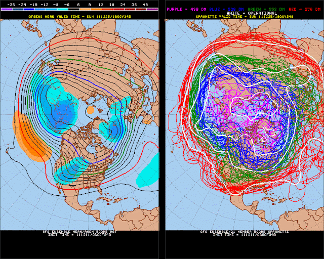
Let't check out some of the ensemble data, as well - ensembles are the same model but tweaked a bit different with each run - gives forecasters a spread of ideas of how something might unfold.
.
Again click images for real view size
.

Let't check out some of the ensemble data, as well - ensembles are the same model but tweaked a bit different with each run - gives forecasters a spread of ideas of how something might unfold.
.
Again click images for real view size
.

.
.
These are basically showing a bit of a trough in the west and a chance for a storm system in or near our region around Christmas.
Now is a GREAT time to buy a NOAA All Hazards Weather Radio. Better to have one before storms strike than to be without one during an event. I recommend the Midland Model 300 NOAA All Hazards Weather Radio - that is what I use here at my house!
.
Meteorologist Beau DodsonMcCracken County Office of Emergency Management
.

.
Beau Dodson Weather - Facebook
.

To view all watches and warnings in Illinois - Click Here
To view all watches and warnings in Kentucky - Click Here
To view all watches and warnings in Missouri - Click Here
To view all watches and warnings in Tennessee - Click Here
.
All other states- Click Here
.
For the latest watches and warnings please visit your local National Weather Service Office web-site.
http://www.weather.gov/organization.php
.
.
Remember most of these maps can be viewed straight off of the Weather Observatory Web-Site
.

.
No comments:
Post a Comment