.
For more frequent updates check out the weather Facebook page - click here and hit like at the top of the page.
.
This page is best viewed with Mozilla Firefox. There could be issues with spacing on Internet Explorer
.

.
This forecast covers far southern Illinois, southeast Missouri, southwest Indiana, western Kentucky, and northwest Tennessee - for your local town/area - click here
.
Here are my current personal forecast thoughts for far southern Illinois and western Kentucky...
.
Saturday night: Mostly clear and not quite as cold. Patchy fog possible.
Below normal temperatures
Lows: in the middle to upper 20s | Normal lows for this time of the year are around 29 degrees.Below normal temperatures
Wind: West winds at 5-10 mph.
Precipitation probability - 0% | Rainfall totals: 0"
Confidence in this forecast is very high
.
Sunday: Some high clouds - otherwise mostly sunny skies.
Above normal temperatures
Highs: around 52 degrees. | Normal highs for this time of the year are around 47 degrees.Above normal temperatures
Wind: South winds at 10 mph
Precipitation probability - 0% | Rainfall totals: 0"
Confidence in this forecast is very high
.
Sunday night: Increasing clouds.
Above normal temperatures
Above normal temperatures
Lows: in the lower to middle 30s | Normal lows for this time of the year are around 29 degrees.
Wind: South winds at 5 mph
Precipitation probability - 0% | Rainfall totals: 0"
Confidence in this forecast is very high
Wind: South winds at 5 mph
Precipitation probability - 0% | Rainfall totals: 0"
Confidence in this forecast is very high
.
Monday: Clouds. A slight chance for a shower.
Above normal temperatures.
Highs: around 54 degrees | Normal highs for this time of the year are around 47 degrees.Wind: Southerly winds at 5-15 mph
Precipitation probability - 30% | Rainfall totals: 0.10-0.20"
.
.
Don't forget to sign up for the severe weather "heads up" email list - I usually email everyone before a big event - severe weather or winter storms - ice storms. Click here to join
.

.


Forecast for your local town/city - Click Here
.
..
Join me on Facebook for more frequent updates on the weather in our local areaClick Here.
.
---

The forecast for severe or extreme weather for the next 24 hours
.
The McCracken County Office of Emergency Management reminds you that owning a NOAA All Hazards Weather Radio is the best way to receive notifications of severe weather watches and warnings.
.
Remember that the National Weather Service defines a severe thunderstorm as one that produces 58 mph winds or higher, hail 1" in size or larger, and/or a tornado. More information with some slides concerning reporting severe weather - click here
.
For the most up to date severe weather outlooks - click here.
or
Visit the Storm Prediction Center's web-site - click here
.
Saturday night: Severe weather is not anticipated. No snow or ice.
Saturday night: Will there be a chance for non-severe thunderstorms? No
.
.
Saturday night: Severe weather is not anticipated. No snow or ice.
Saturday night: Will there be a chance for non-severe thunderstorms? No
.
Sunday: Severe weather is not anticipated. No snow or ice.
Sunday: Will there be a chance for non-severe thunderstorms? No
.Sunday: Will there be a chance for non-severe thunderstorms? No
Sunday night : Severe weather is not anticipated. No snow or ice.
Sunday night: Will there be a chance for non-severe thunderstorms? No
.
Monday: Severe weather is not anticipated. No snow or ice.
Monday: Will there be a risk for non-severe thunderstorms? No
.
Monday: Will there be a risk for non-severe thunderstorms? No
.

.
To view all watches and warnings in IL - Click Here
To view all watches and warnings in KY - Click Here
To view all watches and warnings in MO - Click Here
To view all watches and warnings in TN - Click Here
All other states- Click Here
To view all watches and warnings in IL - Click Here
To view all watches and warnings in KY - Click Here
To view all watches and warnings in MO - Click Here
To view all watches and warnings in TN - Click Here
All other states- Click Here
.
The links above are interactive and you can move around the United States by simply clicking on the national map - or from the pull down menu where it says regions and US States.
.
To view the interactive map - click here.
.
To view the interactive map - click here.
.
.

.
.
HEADLINE: Saturday brought a FROSTY morning to our region - a few patches of freezing fog were also noted near area lakes and rivers.
.
Sunday will be dry - milder with highs into the 50s. Not too bad for the middle of December - that will be above normal in the temperature department.
.
The next chance of rain arrives on Monday and will last into at least Tuesday night or Wednesday. Some disagreement on when the rain exits the region. It also may end as a light mix over the northern portions of our region.
.
A MAJOR winter storm is forecast over the next few days across portions of Oklahoma, Kansas, and into Missouri. Several inches of wind driver snow will fall in those states.
.
Precipitation maps for the next few days - first map is Sunday - then Monday-Wednesday.
.


 .
.

.
The probabilities forecast for this next rain event. The explanation for each probability can be found next to the numbers. I am not a fan of probabilities - however, they do serve a purpose for those interested.
.
Probabilities for rainfall totals - Monday through Wednesday - entire event
There will be a 100% chance of 0.20-0.50" of rain falling - certain chance - an ten out of ten chance
There will be a 90% chance of 0.50-0.75" of rain falling - good chance of occurring - a nine out of ten chance
There will be a 60% chance of 0.75-1.00" of rain falling - medium chance of occurring- a six out of ten chance
There will be a 40% chance of 1.00-1.50" of rain falling - a chance of occurring - a four out of ten chance
There will be a 10% chance of 1.50-2.50" of rain falling - a one out of ten chance.
.
Rivers will remain high - see the latest lake and river stage forecasts - here.
.
HEADLINE: Saturday brought a FROSTY morning to our region - a few patches of freezing fog were also noted near area lakes and rivers.
.
Sunday will be dry - milder with highs into the 50s. Not too bad for the middle of December - that will be above normal in the temperature department.
.
The next chance of rain arrives on Monday and will last into at least Tuesday night or Wednesday. Some disagreement on when the rain exits the region. It also may end as a light mix over the northern portions of our region.
.
A MAJOR winter storm is forecast over the next few days across portions of Oklahoma, Kansas, and into Missouri. Several inches of wind driver snow will fall in those states.
.
Precipitation maps for the next few days - first map is Sunday - then Monday-Wednesday.
.
.
The probabilities forecast for this next rain event. The explanation for each probability can be found next to the numbers. I am not a fan of probabilities - however, they do serve a purpose for those interested.
.
Probabilities for rainfall totals - Monday through Wednesday - entire event
There will be a 100% chance of 0.20-0.50" of rain falling - certain chance - an ten out of ten chance
There will be a 90% chance of 0.50-0.75" of rain falling - good chance of occurring - a nine out of ten chance
There will be a 60% chance of 0.75-1.00" of rain falling - medium chance of occurring- a six out of ten chance
There will be a 40% chance of 1.00-1.50" of rain falling - a chance of occurring - a four out of ten chance
There will be a 10% chance of 1.50-2.50" of rain falling - a one out of ten chance.
.
Rivers will remain high - see the latest lake and river stage forecasts - here.
.
We have a TON of new weather maps on the Weather Observatory web-site - these include temperatures, wind speed, dew points, heat index, barometric pressure, predicted rainfall, climate forecast, medium and long range maps, forecasts and more! Click here
.
.
-----------------------------
.

.
Let's check out the how much rain is forecast to fall over the next 24 hours. This map gives you a general broad brushed idea of what can be expected. Remember the scale is at the top of the map.
.
If you would like to view the most up to date 24, 48, 72, and 120 hour precipitation forecast maps then click here.
.
If you would like to view the most up to date 24, 48, 72, and 120 hour precipitation forecast maps then click here.
.

.

.
You can also now view the probability of X amount of rain (you pick the value on the web-site) in a six hour period of time. Those maps can be viewed here.
.
You can view drought maps on the Weather Observatory web-site by clicking here.
.

You can also now view the probability of X amount of rain (you pick the value on the web-site) in a six hour period of time. Those maps can be viewed here.
.
You can view drought maps on the Weather Observatory web-site by clicking here.
.
.
.
No snow in our forecast...
.
No snow in our forecast...
.
Enhanced snowfall interactive forecast maps . You can choose your total snowfall amounts above the map - time frame, as well- click here
.
Snowfall forecast maps - these are interactive maps. You can choose your total snowfall amounts above the map - time frame, as well - click here
Enhanced snowfall interactive forecast maps . You can choose your total snowfall amounts above the map - time frame, as well- click here
.
Snowfall forecast maps - these are interactive maps. You can choose your total snowfall amounts above the map - time frame, as well - click here
.
If you are looking for wintry precipitation - click here.
.
.

.
You can view the upcoming days high temperature and low temperature forecasts by clicking here - choose the day - click on your state to zoom in
You can view the upcoming days high temperature and low temperature forecasts by clicking here - choose the day - click on your state to zoom in
.
 .
. We have a number of new radars available on our Weather Observatory web-site!
---
We now offer St Louis, Mt Vernon, Evansville, Poplar Bluff, Cape Girardeau, Marion, Paducah, Hopkinsville, and Dyersburg Interactive City Radars. We also have the two regional radars and now offer you three GR Earth radars.
http://www.weatherobservatory.com/weather-radar.htm---
---
We also have a new interactive radar - you can view that radar by clicking here.
.
Want to learn more about how to use our radars? I made a how to video with more information
Click here - http://www.youtube.com/watch?v=bfLa0hI3adU
.
.
.
.
---

.
.
Date Range: December 18th - December 22nd
Event: Precipitation events
Severe Risk:
Frozen Precipitation Risk:
Details: A more significant storm system possible in or near our region. A mix of above and below normal temperatures. Rainfall of 0.40-0.80" possible with the Monday/Tuesday system - another chance for precipitation around Thursday/Friday
Confidence in my forecast. Very High
.
.
Date Range: December 23rd-29th
Event: Significant storm system in the Missouri/Ohio/Tennessee Valley - more below normal temperatures days vs above normal days.
Severe Risk:
Frozen Precipitation Risk:
Details: Potential precipitation events.
Confidence in my forecast: Medium
.
.
Date Range: December 26th-January 15th
Event: Potential for bitterly cold air masses mixed in with above normal temperatures
Severe Risk:
Frozen Precipitation Risk: 3-5 potential precipitation events
Details: Potential precipitation event and perhaps below normal temperatures. Uncertainty surrounds the NAO going negative - some blocking in the Atlantic.
Confidence in my forecast: Low
.
.
Remember that as a general policy, in the long range outlook, I will NOT mention severe thunderstorms more than 72 hours in advance. I will mention thunderstorm risks and I will give as many details as possible. The word severe will be reserved for the short range forecast.
.
-----------------------------
.
1. Shorter update today - no big changes in the long range.
.
Will be watching one system for Thursday/Friday - still a bit iffy on the details on that system.
.
I continue to monitor the potential for precipitation on Saturday/Sunday of next week. EC model says not going to happen - GFS says maybe. This run of the GFS is a bit warm and would indicate rain for Christmas Day.
.
The majority of ensemble model runs are showing dry weather here for Christmas weekend. This is a fast flow atmosphere - disturbances seems to be moving through our region every few days - I won't rule out precipitation Christmas weekend just yet.
.
Some NWS offices are now saying Christmas weekend will be dry - other offices are saying they just are not sure yet. Guess we will continue to monitor and update in the coming days!
.
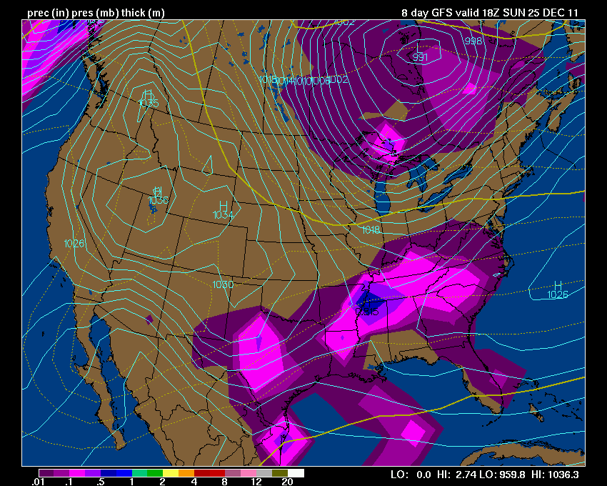
Here are the GFS maps from www.wright-weather.com
.

.

.
Will be watching one system for Thursday/Friday - still a bit iffy on the details on that system.
.
I continue to monitor the potential for precipitation on Saturday/Sunday of next week. EC model says not going to happen - GFS says maybe. This run of the GFS is a bit warm and would indicate rain for Christmas Day.
.
The majority of ensemble model runs are showing dry weather here for Christmas weekend. This is a fast flow atmosphere - disturbances seems to be moving through our region every few days - I won't rule out precipitation Christmas weekend just yet.
.
Some NWS offices are now saying Christmas weekend will be dry - other offices are saying they just are not sure yet. Guess we will continue to monitor and update in the coming days!
.
Here are the GFS maps from www.wright-weather.com
.
.

.
Now is a GREAT time to buy a NOAA All Hazards Weather Radio. Better to have one before storms strike than to be without one during an event. I recommend the Midland Model 300 NOAA All Hazards Weather Radio - that is what I use here at my house!
.
Meteorologist Beau DodsonMcCracken County Office of Emergency Management
.

.
Beau Dodson Weather - Facebook
.

To view all watches and warnings in Illinois - Click Here
To view all watches and warnings in Kentucky - Click Here
To view all watches and warnings in Missouri - Click Here
To view all watches and warnings in Tennessee - Click Here
.
All other states- Click Here
.
For the latest watches and warnings please visit your local National Weather Service Office web-site.
http://www.weather.gov/organization.php
.
.
Remember most of these maps can be viewed straight off of the Weather Observatory Web-Site
.

.
No comments:
Post a Comment