.
For more frequent updates check out the weather Facebook page - click here and hit like at the top of the page.
.
This page is best viewed with Mozilla Firefox. There could be issues with spacing on Internet Explorer
.

.
This forecast covers far southern Illinois, southeast Missouri, southwest Indiana, western Kentucky, and northwest Tennessee - for your local town/area - click here
.
Here are my current personal forecast thoughts for far southern Illinois and western Kentucky...
.
Friday night: Decreasing cloudiness and colder. Some fog possible late.
Below normal temperatures
Lows: in the middle to upper 20s | Normal lows for this time of the year are around 29 degrees.Below normal temperatures
Wind: Northwest winds at 5-10 mph.
Precipitation probability - 0% | Rainfall totals: 0"
Confidence in this forecast is very high
.
Saturday: Some morning fog possible. Otherwise - mostly sunny skies with just a few high clouds. Below normal temperatures.
Highs: around 44-46 degrees. | Normal highs for this time of the year are around 47 degrees.Wind: Southwest winds at 10 mph
Precipitation probability - 0% | Rainfall totals: 0"
Confidence in this forecast is very high
.
Saturday night: Mostly clear skies. A bit of fog possible.
Near normal temperatures
Near normal temperatures
Lows: around 26-30 degrees | Normal lows for this time of the year are around 29 degrees.
Wind: West winds at 5 mph
Precipitation probability - 0% | Rainfall totals: 0"
Confidence in this forecast is very high
Wind: West winds at 5 mph
Precipitation probability - 0% | Rainfall totals: 0"
Confidence in this forecast is very high
.
Sunday: A few clouds - otherwise sunny and milder.
Above normal temperatures.
Highs: around 50-55 degrees | Normal highs for this time of the year are around 47 degrees.Wind: Southerly winds at 5-15 mph
Precipitation probability - 0% | Rainfall totals: 0"
.
.
Don't forget to sign up for the severe weather "heads up" email list - I usually email everyone before a big event - severe weather or winter storms - ice storms. Click here to join
.

.


Forecast for your local town/city - Click Here
.
..
Join me on Facebook for more frequent updates on the weather in our local areaClick Here.
.
---

The forecast for severe or extreme weather for the next 24 hours
.
The McCracken County Office of Emergency Management reminds you that owning a NOAA All Hazards Weather Radio is the best way to receive notifications of severe weather watches and warnings.
.
Remember that the National Weather Service defines a severe thunderstorm as one that produces 58 mph winds or higher, hail 1" in size or larger, and/or a tornado. More information with some slides concerning reporting severe weather - click here
.
For the most up to date severe weather outlooks - click here.
or
Visit the Storm Prediction Center's web-site - click here
.
Friday night: Severe weather is not anticipated. No snow or ice.
Friday night: Will there be a chance for non-severe thunderstorms? No
.
.
Friday night: Severe weather is not anticipated. No snow or ice.
Friday night: Will there be a chance for non-severe thunderstorms? No
.
Saturday: Severe weather is not anticipated. No snow or ice.
Saturday: Will there be a chance for non-severe thunderstorms? No
.Saturday: Will there be a chance for non-severe thunderstorms? No
Saturday night : Severe weather is not anticipated. No snow or ice.
Saturday night: Will there be a chance for non-severe thunderstorms? No
.
Sunday: Severe weather is not anticipated. No snow or ice.
Sunday: Will there be a risk for non-severe thunderstorms? No
.
Sunday: Will there be a risk for non-severe thunderstorms? No
.

.
To view all watches and warnings in IL - Click Here
To view all watches and warnings in KY - Click Here
To view all watches and warnings in MO - Click Here
To view all watches and warnings in TN - Click Here
All other states- Click Here
To view all watches and warnings in IL - Click Here
To view all watches and warnings in KY - Click Here
To view all watches and warnings in MO - Click Here
To view all watches and warnings in TN - Click Here
All other states- Click Here
.
The links above are interactive and you can move around the United States by simply clicking on the national map - or from the pull down menu where it says regions and US States.
.
To view the interactive map - click here.
.
To view the interactive map - click here.
.
.

.
.
HEADLINE: A mixture of rain and sleet pushed across the area this morning (Friday morning). No accumulation occurred - more of a novelty than anything else. A few reports of snow were received from areas a bit east of western Kentucky. The atmosphere above us was a bit too warm for snow in our region - nose of warmer air. Thus the reason for the sleet vs snow.
.
Rainfall totals were on the light side, as expected.
.
There may be some fog tonight and Saturday night - otherwise dry conditions will prevail through Sunday.
.
High temperatures for Saturday and Sunday - below
.

 .
.
The next in a series of weather makers will arrive on Monday - this will bring additional shower chances to the region. Rainfall totals are expected to be in the 0.40-0.80" range - will fine tune the totals as we draw a bit closer to the event.
.
I did run the analog computer site on this next storm system (Monday into Wednesday) and it does have some heavy rain signals - but more likely just to our west. However, this will need to be monitored as it could shift around a bit - especially if the system slows a tad. Right now I will stick with the 0.40-0.80" for general rainfall totals. Will update again tomorrow and Sunday.
.
Here is the analog showing the mean precipitation with similar storms in the past - you can see quite a bit of rain and some of it heavy.
.

.
Right now I think the bulk of the rain will fall later on Monday into Tuesday. Monday morning may remain dry.
.
Monday and Tuesday's precipitation map - below
.
 .
.
Rain will continue on/off into Tuesday. Wednesday may have some light rain left over - then another shot at rain on Thursday or Friday of next week as an area of low pressure pulls out of the Gulf region.
.
Rivers will remain high - see the latest lake and river stage forecasts - here.
.
HEADLINE: A mixture of rain and sleet pushed across the area this morning (Friday morning). No accumulation occurred - more of a novelty than anything else. A few reports of snow were received from areas a bit east of western Kentucky. The atmosphere above us was a bit too warm for snow in our region - nose of warmer air. Thus the reason for the sleet vs snow.
.
Rainfall totals were on the light side, as expected.
.
There may be some fog tonight and Saturday night - otherwise dry conditions will prevail through Sunday.
.
High temperatures for Saturday and Sunday - below
.
The next in a series of weather makers will arrive on Monday - this will bring additional shower chances to the region. Rainfall totals are expected to be in the 0.40-0.80" range - will fine tune the totals as we draw a bit closer to the event.
.
I did run the analog computer site on this next storm system (Monday into Wednesday) and it does have some heavy rain signals - but more likely just to our west. However, this will need to be monitored as it could shift around a bit - especially if the system slows a tad. Right now I will stick with the 0.40-0.80" for general rainfall totals. Will update again tomorrow and Sunday.
.
Here is the analog showing the mean precipitation with similar storms in the past - you can see quite a bit of rain and some of it heavy.
.
.
Right now I think the bulk of the rain will fall later on Monday into Tuesday. Monday morning may remain dry.
.
Monday and Tuesday's precipitation map - below
.
Rain will continue on/off into Tuesday. Wednesday may have some light rain left over - then another shot at rain on Thursday or Friday of next week as an area of low pressure pulls out of the Gulf region.
.
Rivers will remain high - see the latest lake and river stage forecasts - here.
.
We have a TON of new weather maps on the Weather Observatory web-site - these include temperatures, wind speed, dew points, heat index, barometric pressure, predicted rainfall, climate forecast, medium and long range maps, forecasts and more! Click here
.
.
-----------------------------
.

.
Let's check out the how much rain is forecast to fall over the next 24 hours. This map gives you a general broad brushed idea of what can be expected. Remember the scale is at the top of the map.
.
If you would like to view the most up to date 24, 48, 72, and 120 hour precipitation forecast maps then click here.
.
If you would like to view the most up to date 24, 48, 72, and 120 hour precipitation forecast maps then click here.
.

Here is the FIVE day rainfall forecast - this takes us right on through the next event (through next Wednesday morning)
.

.
.

.
You can also now view the probability of X amount of rain (you pick the value on the web-site) in a six hour period of time. Those maps can be viewed here.
.
You can view drought maps on the Weather Observatory web-site by clicking here.
.

You can also now view the probability of X amount of rain (you pick the value on the web-site) in a six hour period of time. Those maps can be viewed here.
.
You can view drought maps on the Weather Observatory web-site by clicking here.
.
.
.
No snow in our forecast...
.
No snow in our forecast...
.
Enhanced snowfall interactive forecast maps . You can choose your total snowfall amounts above the map - time frame, as well- click here
.
Snowfall forecast maps - these are interactive maps. You can choose your total snowfall amounts above the map - time frame, as well - click here
Enhanced snowfall interactive forecast maps . You can choose your total snowfall amounts above the map - time frame, as well- click here
.
Snowfall forecast maps - these are interactive maps. You can choose your total snowfall amounts above the map - time frame, as well - click here
.
If you are looking for wintry precipitation - click here.
.
.

.
You can view the upcoming days high temperature and low temperature forecasts by clicking here - choose the day - click on your state to zoom in
You can view the upcoming days high temperature and low temperature forecasts by clicking here - choose the day - click on your state to zoom in
.
 .
. We have a number of new radars available on our Weather Observatory web-site!
---
We now offer St Louis, Mt Vernon, Evansville, Poplar Bluff, Cape Girardeau, Marion, Paducah, Hopkinsville, and Dyersburg Interactive City Radars. We also have the two regional radars and now offer you three GR Earth radars.
http://www.weatherobservatory.com/weather-radar.htm---
---
We also have a new interactive radar - you can view that radar by clicking here.
.
Want to learn more about how to use our radars? I made a how to video with more information
Click here - http://www.youtube.com/watch?v=bfLa0hI3adU
.
.
.
.
---

.
.
I put together the long range forecast to give you a general idea of weather patterns beyond the short range period. The accuracy of forecasts beyond 7-10 days can be quite low. Use the long range forecast to give yourself a general idea of upcoming events. However, check back often for updates. I normally will give you a broad range of dates where an event is possible - I then will zero in on the date and event details as we draw closer to that particular period of time.
.
.
Date Range: December 11th - December 18th
Event: Swings in temperatures.
Severe Risk:
Frozen Precipitation Risk: One or two precipitation events possible - watching the 14th-16th time period for one event - right now data is showing a rain event. Another event around the 18th (onward).
Details: Transition period with swings from above to below normal temperatures. A chance for one or two precipitation events, Locally heavy rain again possible.
Confidence in my forecast. Very High
.
.
Date Range: December 18th - December 22nd
Event: Precipitation events
Severe Risk:
Frozen Precipitation Risk:
Details: A more significant storm system possible in or near our region. A mix of above and below normal temperatures. Rainfall of 0.40-0.80" possible with the Monday/Tuesday system - another chance for precipitation around Thursday
Confidence in my forecast. Very High
.
.
Date Range: December 23rd-29th
Event: Significant storm system in the Missouri/Ohio/Tennessee Valley - more below normal temperatures days vs above normal days.
Severe Risk:
Frozen Precipitation Risk:
Details: Potential precipitation events.
Confidence in my forecast: Medium
.
.
Date Range: December 26th-January 15th
Event: Potential for bitterly cold air masses mixed in with above normal temperatures
Severe Risk:
Frozen Precipitation Risk: 3-5 potential precipitation events
Details: Potential precipitation event and perhaps below normal temperatures. Uncertainty surrounds the NAO going negative - some blocking in the Atlantic.
Confidence in my forecast: Low
.
.
Remember that as a general policy, in the long range outlook, I will NOT mention severe thunderstorms more than 72 hours in advance. I will mention thunderstorm risks and I will give as many details as possible. The word severe will be reserved for the short range forecast.
.
-----------------------------
.
1. Well - we keep looking for snow - portions of the region have already picked up anywhere from a dusting to five/six inches so far this year. Most of that was the event a few weeks ago that produced the stripe of thundersnow across parts of southern Illinois, western Kentucky, southeast Missouri, and then down into Arkansas and Tennessee. Some of you can't complain about the lack of snow! However, for the rest of you snow lovers - you will have to wait a bit longer.
.
I don't see anything in the short range that grabs my snow attention. We have an extremely active flow with multiple storm systems to watch in the coming days. No strong signals for a winter storm - at this time.
.
Discussion on the Monday/Tuesday event can be read above. There is a small chance that the precipitation on Wednesday could end as a light flake of snow or two. I wouldn't include it in the forecast just yet - odds of that favor areas to our north more than here.
.
The next storm may arrive around Thursday or Friday - models are not clear just yet. It appears that an area of low pressure will move out of the southern states - northeast. This will spread the chance for additional showers into our region. Right now it appears warm enough for rain - although some of the data shows it cold enough in some of our counties for mixed precipitation. I will monitor that system and update accordingly.
.
The Christmas system - Christmas weekend system - is still in play. Models have been ALL over the place with this storm. Some runs show a big storm moving out of the Gulf of Mexico while other runs take the low so far south that it has little or no impact on our regions weather.
.
Tough call - this has been a time frame (December 23rd-30th) I have been watching for the last six weeks - around Christmas weekend into the last week of December for a big storm to impact the Ohio and Tennessee Valley region - southward. Will it happen?
.
Ensemble data indicate a decent shot at a big storm system around that time frame over parts of the regions mentioned above - the questions are timing and placement of the main features.
.
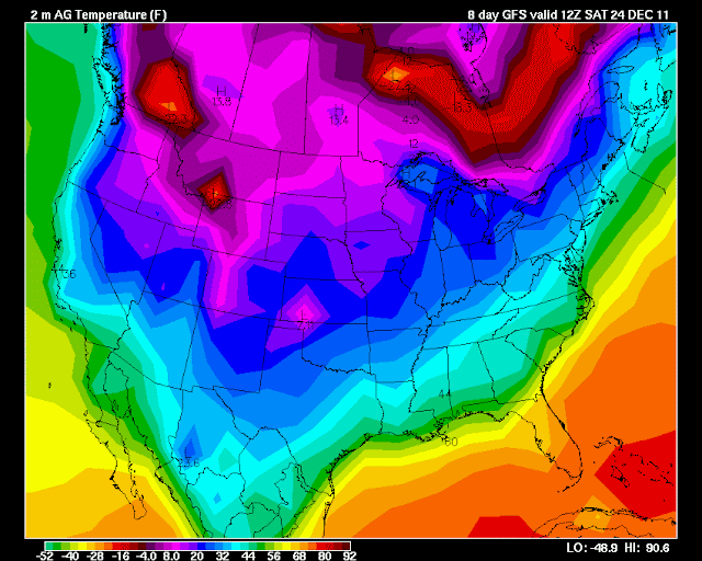
The maps below show you the precipitation/surface maps for Friday - Saturday - Sunday - Monday of Christmas weekend and then the temperatures. You can see that the data is showing COLD for Christmas weekend - then you can see how close the precipitation is to our region.
.
Mixed signals - some lean dry and some lean wet. This has been the only consistent part of the long range model data - inconsistency.
.
One thing of interest - and you can read my thoughts over the last few days in my previous posts - is that the models have had wild swings from one run to the next. Some showing temperatures into the SIXTIES here Christmas Eve and thunderstorms - then the next run showing snow flurries and TWENTIES. What does that tell us? It tells us that the models are having a very difficult time handling the fast southwest flow and the number of disturbances moving through the region.
.
Will keep the chance for a white Christmas at 10% - no change from the last two weeks worth of thoughts. Still going to have to monitor the timing of the Christmas weekend event - or perhaps even a a bit after Christmas.
.
Here is what the GFS is showing - again this is a still quite a few days away. I call this fantasy land for models because their accuracy beyond day 4 or 5 is very low. Let's monitor it each day or two and see where it goes. Again maps are from www.wright-weather.com and click the image for full view size.
.
 .
.
Check back in again tomorrow - let's see how it has changed. We will ride the GFS roller-coaster together!
.
Latest maps from www.wright-weather.com - shows the system and temperatures. I will keep the chances for a white Christmas at 10% - no change
.
Click images for real view size - dates/times can be viewed at the top of each image . Click image for real view size (12z = around 6 to 7 am and 0z = around 6 or 7 pm)
.


.
I don't see anything in the short range that grabs my snow attention. We have an extremely active flow with multiple storm systems to watch in the coming days. No strong signals for a winter storm - at this time.
.
Discussion on the Monday/Tuesday event can be read above. There is a small chance that the precipitation on Wednesday could end as a light flake of snow or two. I wouldn't include it in the forecast just yet - odds of that favor areas to our north more than here.
.
The next storm may arrive around Thursday or Friday - models are not clear just yet. It appears that an area of low pressure will move out of the southern states - northeast. This will spread the chance for additional showers into our region. Right now it appears warm enough for rain - although some of the data shows it cold enough in some of our counties for mixed precipitation. I will monitor that system and update accordingly.
.
The Christmas system - Christmas weekend system - is still in play. Models have been ALL over the place with this storm. Some runs show a big storm moving out of the Gulf of Mexico while other runs take the low so far south that it has little or no impact on our regions weather.
.
Tough call - this has been a time frame (December 23rd-30th) I have been watching for the last six weeks - around Christmas weekend into the last week of December for a big storm to impact the Ohio and Tennessee Valley region - southward. Will it happen?
.
Ensemble data indicate a decent shot at a big storm system around that time frame over parts of the regions mentioned above - the questions are timing and placement of the main features.
.
The maps below show you the precipitation/surface maps for Friday - Saturday - Sunday - Monday of Christmas weekend and then the temperatures. You can see that the data is showing COLD for Christmas weekend - then you can see how close the precipitation is to our region.
.
Mixed signals - some lean dry and some lean wet. This has been the only consistent part of the long range model data - inconsistency.
.
One thing of interest - and you can read my thoughts over the last few days in my previous posts - is that the models have had wild swings from one run to the next. Some showing temperatures into the SIXTIES here Christmas Eve and thunderstorms - then the next run showing snow flurries and TWENTIES. What does that tell us? It tells us that the models are having a very difficult time handling the fast southwest flow and the number of disturbances moving through the region.
.
Will keep the chance for a white Christmas at 10% - no change from the last two weeks worth of thoughts. Still going to have to monitor the timing of the Christmas weekend event - or perhaps even a a bit after Christmas.
.
Here is what the GFS is showing - again this is a still quite a few days away. I call this fantasy land for models because their accuracy beyond day 4 or 5 is very low. Let's monitor it each day or two and see where it goes. Again maps are from www.wright-weather.com and click the image for full view size.
.
.Check back in again tomorrow - let's see how it has changed. We will ride the GFS roller-coaster together!
.
Latest maps from www.wright-weather.com - shows the system and temperatures. I will keep the chances for a white Christmas at 10% - no change
.
Click images for real view size - dates/times can be viewed at the top of each image . Click image for real view size (12z = around 6 to 7 am and 0z = around 6 or 7 pm)
.


.
Now is a GREAT time to buy a NOAA All Hazards Weather Radio. Better to have one before storms strike than to be without one during an event. I recommend the Midland Model 300 NOAA All Hazards Weather Radio - that is what I use here at my house!
.
Meteorologist Beau DodsonMcCracken County Office of Emergency Management
.

.
Beau Dodson Weather - Facebook
.

To view all watches and warnings in Illinois - Click Here
To view all watches and warnings in Kentucky - Click Here
To view all watches and warnings in Missouri - Click Here
To view all watches and warnings in Tennessee - Click Here
.
All other states- Click Here
.
For the latest watches and warnings please visit your local National Weather Service Office web-site.
http://www.weather.gov/organization.php
.
.
Remember most of these maps can be viewed straight off of the Weather Observatory Web-Site
.

.
No comments:
Post a Comment