.
For more frequent updates check out the weather Facebook page - click here and hit like at the top of the page.
.
This page is best viewed with Mozilla Firefox. There could be issues with spacing on Internet Explorer
.

.
This forecast covers far southern Illinois, southeast Missouri, southwest Indiana, western Kentucky, and northwest Tennessee - for your local town/area - click here
.
Here are my current personal forecast thoughts for far southern Illinois and western Kentucky...
.
Wednesday night: Showers and thunderstorms likely - a few heavy downpours possible.
Above normal temperatures
Lows: in the middle to upper 50s | Normal lows for this time of the year are around 30 degrees.Above normal temperatures
Wind: Southerly winds at 10-20 mph.
Precipitation probability - 100% | Rainfall totals before 7 am: 0.25-0.60"
Confidence in this forecast is very high
.
Thursday: A morning chance for showers - then cloudy with a few showers possible during the afternoon. Turning colder. Highs will be early in the day.
Above normal temperatures.
Highs: around 60 degrees early AM hours then falling through the day | Normal highs for this time of the year are around 48 degrees.Above normal temperatures.
Wind: Westerly winds at 10-20 mph - gusts to 30 mph
Precipitation probability - 60% early then 40% late in the day | Rainfall totals after 7 am: 0.10"-0.40"
Confidence in this forecast is very high
.
Thursday night: Mostly cloudy and cooler. Rain or rain/snow possible late.
Above normal temperatures
Above normal temperatures
Lows: in the middle 30s | Normal lows for this time of the year are around 30 degrees.
Wind: Northerly winds at 10 mph
Precipitation probability - 40% | Rainfall totals: 0.050.10"
Confidence in this forecast is very high
Wind: Northerly winds at 10 mph
Precipitation probability - 40% | Rainfall totals: 0.050.10"
Confidence in this forecast is very high
.
Friday: Mostly cloudy. A good chance for rain and snow/sleet. Colder.
Below normal temperatures.
Highs: around 35-42 degrees | Normal highs for this time of the year are around 48 degrees.Wind: Northeast winds at 5-15 mph
Precipitation probability - 70% | Rainfall totals: 0.10"-0.30"
.
.
Don't forget to sign up for the severe weather "heads up" email list - I usually email everyone before a big event - severe weather or winter storms - ice storms. Click here to join
.

.


Forecast for your local town/city - Click Here
.
..
Join me on Facebook for more frequent updates on the weather in our local areaClick Here.
.
---

The forecast for severe or extreme weather for the next 24 hours
.
The McCracken County Office of Emergency Management reminds you that owning a NOAA All Hazards Weather Radio is the best way to receive notifications of severe weather watches and warnings.
.
Remember that the National Weather Service defines a severe thunderstorm as one that produces 58 mph winds or higher, hail 1" in size or larger, and/or a tornado. More information with some slides concerning reporting severe weather - click here
.
For the most up to date severe weather outlooks - click here.
or
Visit the Storm Prediction Center's web-site - click here
.
Wednesday night: Severe weather is not anticipated. No snow or ice.
Wednesday night: Will there be a chance for non-severe thunderstorms? Yes - some thunder possible
.
.
Wednesday night: Severe weather is not anticipated. No snow or ice.
Wednesday night: Will there be a chance for non-severe thunderstorms? Yes - some thunder possible
.
Thursday: Severe weather is not anticipated. No snow or ice.
Thursday: Will there be a chance for non-severe thunderstorms? Yes - some early morning thunder
.Thursday: Will there be a chance for non-severe thunderstorms? Yes - some early morning thunder
Thursday night : Severe weather is not anticipated. A mixture of precipitation possible late
Thursday night: Will there be a chance for non-severe thunderstorms? No
.
Friday: Severe weather is not anticipated. Snow, sleet, and rain likely over the central and southern half of the region. Some light accumulation is possible.
Friday: Will there be a risk for non-severe thunderstorms? No
.
Friday: Will there be a risk for non-severe thunderstorms? No
.

.
To view all watches and warnings in IL - Click Here
To view all watches and warnings in KY - Click Here
To view all watches and warnings in MO - Click Here
To view all watches and warnings in TN - Click Here
All other states- Click Here
To view all watches and warnings in IL - Click Here
To view all watches and warnings in KY - Click Here
To view all watches and warnings in MO - Click Here
To view all watches and warnings in TN - Click Here
All other states- Click Here
.
The links above are interactive and you can move around the United States by simply clicking on the national map - or from the pull down menu where it says regions and US States.
.
To view the interactive map - click here.
.
To view the interactive map - click here.
.
.

.
.
HEADLINE: Another foggy and cloudy day across our region. We are positioned ahead of a cold front which will bring us showers and thunderstorms later tonight (Wednesday night). A few heavy downpours will be possible - thunder possible. No severe weather is expected in our region.
.
The probabilities forecast for this next rain event. The explanation for each probability can be found next to the numbers. I am not a fan of probabilities - however, they do serve a purpose for those interested.
.
This is for Wednesday night through Thursday night
There will be a 90% chance of 0.10-0.25" of rain falling - near certain chance - a nine out of ten chance
There will be a 70% chance of 0.25-0.50" of rain falling - excellent chance of occurring - a seven out of ten chance
There will be a 50% chance of 0.50-0.75" of rain falling - likely chance of occurring- a five out of ten chance
There will be a 40% chance of 0.75-1.00" of rain falling - a low chance of occurring - a four out of ten chance
There will be a 20% chance of 1.00-1.50" of rain falling - a two out of ten chance
There will be a 10% chance of 1.50-2.00" of rain falling - a one out of ten chance
There will be a 5% chance of 2.00"+ of rain falling
.
Thursday will bring a few showers and falling temperatures through the day. Friday will bring below normal temperatures - we will be above normal again by Sunday.
.
Rain will redevelop on Thursday night - rain may mix with or change to sleet and snow over parts of the region on Friday. Right now accumulations - if any - would be on the light side (less than 1" is the general feeling at this time)
.
More rain arrives Sunday night into Tuesday - rainfall totals are likely going to be in the 0.20-0.50" for that event - still some time to monitor and tweak if need be. Can't rule out a rumble of thunder on Monday, as well. No severe weather is forecast.
.
Active pattern right on through the end of the month with several storm systems to monitor. Still do not see a major snowstorm in the cards. I will keep watching.
.
Here are the precipitation maps for the next few days - KEEP IN MIND that the Sunday-Monday map is showing precipitation that should arrive Sunday night into Monday - most of Sunday should be dry!
.
Timestamps for each image are near the top - above the map
.


.
Rivers will remain high - see the latest lake and river stage forecasts - here.
.
HEADLINE: Another foggy and cloudy day across our region. We are positioned ahead of a cold front which will bring us showers and thunderstorms later tonight (Wednesday night). A few heavy downpours will be possible - thunder possible. No severe weather is expected in our region.
.
The probabilities forecast for this next rain event. The explanation for each probability can be found next to the numbers. I am not a fan of probabilities - however, they do serve a purpose for those interested.
.
This is for Wednesday night through Thursday night
There will be a 90% chance of 0.10-0.25" of rain falling - near certain chance - a nine out of ten chance
There will be a 70% chance of 0.25-0.50" of rain falling - excellent chance of occurring - a seven out of ten chance
There will be a 50% chance of 0.50-0.75" of rain falling - likely chance of occurring- a five out of ten chance
There will be a 40% chance of 0.75-1.00" of rain falling - a low chance of occurring - a four out of ten chance
There will be a 20% chance of 1.00-1.50" of rain falling - a two out of ten chance
There will be a 10% chance of 1.50-2.00" of rain falling - a one out of ten chance
There will be a 5% chance of 2.00"+ of rain falling
.
Thursday will bring a few showers and falling temperatures through the day. Friday will bring below normal temperatures - we will be above normal again by Sunday.
.
Rain will redevelop on Thursday night - rain may mix with or change to sleet and snow over parts of the region on Friday. Right now accumulations - if any - would be on the light side (less than 1" is the general feeling at this time)
.
More rain arrives Sunday night into Tuesday - rainfall totals are likely going to be in the 0.20-0.50" for that event - still some time to monitor and tweak if need be. Can't rule out a rumble of thunder on Monday, as well. No severe weather is forecast.
.
Active pattern right on through the end of the month with several storm systems to monitor. Still do not see a major snowstorm in the cards. I will keep watching.
.
Here are the precipitation maps for the next few days - KEEP IN MIND that the Sunday-Monday map is showing precipitation that should arrive Sunday night into Monday - most of Sunday should be dry!
.
Timestamps for each image are near the top - above the map
.
.
Rivers will remain high - see the latest lake and river stage forecasts - here.
.
We have a TON of new weather maps on the Weather Observatory web-site - these include temperatures, wind speed, dew points, heat index, barometric pressure, predicted rainfall, climate forecast, medium and long range maps, forecasts and more! Click here
.
.
-----------------------------
.

.
Let's check out the how much rain is forecast to fall over the next 72 hours. This map gives you a general broad brushed idea of what can be expected. Remember the scale is at the top of the map.
.
If you would like to view the most up to date 24, 48, 72, and 120 hour precipitation forecast maps then click here.
.
If you would like to view the most up to date 24, 48, 72, and 120 hour precipitation forecast maps then click here.
.

.

.
You can also now view the probability of X amount of rain (you pick the value on the web-site) in a six hour period of time. Those maps can be viewed here.
.
You can view drought maps on the Weather Observatory web-site by clicking here.
.

You can also now view the probability of X amount of rain (you pick the value on the web-site) in a six hour period of time. Those maps can be viewed here.
.
You can view drought maps on the Weather Observatory web-site by clicking here.
.
.
.
Snow will be possible on Thursday night (late) and Friday - a mixture of rain/sleet/snow will likely occur in some of our counties. Right now there is not much agreement on where the rain/snow line will end up. Temperatures will be borderline for frozen precipitation. However, the general agreement among forecasters is that it is going to be close enough to mention the potential. If rain does change to snow then a dusting to an inch can't be ruled out in a few spots.
.
Enhanced snowfall interactive forecast maps . You can choose your total snowfall amounts above the map - time frame, as well- click here
.
Snowfall forecast maps - these are interactive maps. You can choose your total snowfall amounts above the map - time frame, as well - click here
Enhanced snowfall interactive forecast maps . You can choose your total snowfall amounts above the map - time frame, as well- click here
.
Snowfall forecast maps - these are interactive maps. You can choose your total snowfall amounts above the map - time frame, as well - click here
.
If you are looking for wintry precipitation - click here.
.
.

.
You can view the upcoming days high temperature and low temperature forecasts by clicking here - choose the day - click on your state to zoom in
You can view the upcoming days high temperature and low temperature forecasts by clicking here - choose the day - click on your state to zoom in
.
 .
. We have a number of new radars available on our Weather Observatory web-site!
---
We now offer St Louis, Mt Vernon, Evansville, Poplar Bluff, Cape Girardeau, Marion, Paducah, Hopkinsville, and Dyersburg Interactive City Radars. We also have the two regional radars and now offer you three GR Earth radars.
http://www.weatherobservatory.com/weather-radar.htm---
---
We also have a new interactive radar - you can view that radar by clicking here.
.
Want to learn more about how to use our radars? I made a how to video with more information
Click here - http://www.youtube.com/watch?v=bfLa0hI3adU
.
.
.
.
---

.
.
I put together the long range forecast to give you a general idea of weather patterns beyond the short range period. The accuracy of forecasts beyond 7-10 days can be quite low. Use the long range forecast to give yourself a general idea of upcoming events. However, check back often for updates. I normally will give you a broad range of dates where an event is possible - I then will zero in on the date and event details as we draw closer to that particular period of time.
.
.
Date Range: December 11th - December 18th
Event: Swings in temperatures.
Severe Risk:
Frozen Precipitation Risk: One or two precipitation events possible - watching the 14th-16th time period for one event - right now data is showing a rain event. Another event around the 18th (onward).
Details: Transition period with swings from above to below normal temperatures. A chance for one or two precipitation events, Locally heavy rain again possible.
Confidence in my forecast. Very High
.
.
Date Range: December 18th - December 22nd
Event: Precipitation event
Severe Risk:
Frozen Precipitation Risk:
Details: A more significant storm system possible in or near our region. A mix of above and below normal temperatures. Rainfall of 0.40-0.80" possible with the Monday/Tuesday system
Confidence in my forecast. High
.
.
Date Range: December 23rd-29th
Event: Significant storm system in the Missouri/Ohio/Tennessee Valley - more below normal temperatures days vs above normal days. Most likely time frame for the bigger system is towards the end dates.
Severe Risk:
Frozen Precipitation Risk:
Details: Potential precipitation event.
Confidence in my forecast: Low
.
.
Date Range: December 26th-January 15th
Event: Potential for bitterly cold air masses mixed in with above normal temperatures
Severe Risk:
Frozen Precipitation Risk: 3-5 potential precipitation events
Details: Potential precipitation event and perhaps below normal temperatures. Uncertainty surrounds the NAO going negative - some blocking in the Atlantic.
Confidence in my forecast: Low
.
.
.
Remember that as a general policy, in the long range outlook, I will NOT mention severe thunderstorms more than 72 hours in advance. I will mention thunderstorm risks and I will give as many details as possible. The word severe will be reserved for the short range forecast.
.
-----------------------------
.
1. Long range appears unsettled with several precipitation chances in the long term - through the end of the month. See the above for my thoughts on dates and temperatures.
.
AND I promised you we would take a look at Christmas Eve and Christmas Day
.
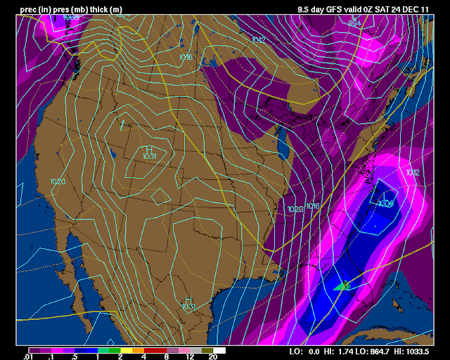
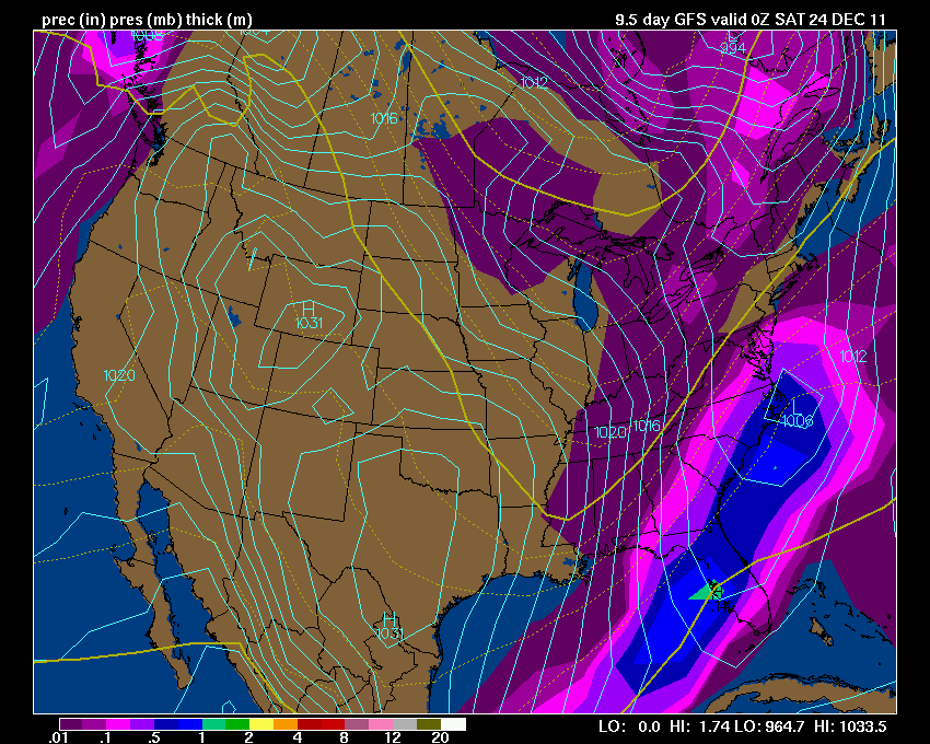
Here is what the GFS is showing - again this is a still quite a few days away. I call this fantasy land for models because their accuracy beyond day 4 or 5 is very low. Let's monitor it each day or two and see where it goes. Again maps are from www.wright-weather.com and click the image for full view size.
.
 .
.
Check back in again tomorrow - let's see how it has changed. We will ride the GFS roller-coaster together!
.
Latest maps from www.wright-weather.com - shows the storm and temperatures. I will keep the chances for a white Christmas at 10% - no change
.
Click images for real view size - dates can be viewed at the top of each image - first three are surface maps - precipitation. The last three maps are temperatures.
.
Today's data shows COLD for Christmas Eve and Christmas Day - just a chance for light rain or snow showers. The GFS has taken away the big system. However, models tend to lose storms in this time frame - will need to continue to monitor and see what happens. The big change today is much colder temps on the long range maps.
.
I believe the storm could be further south and stronger than today's models indicate. Stay tuned!
.
Click image for real view size
.
.
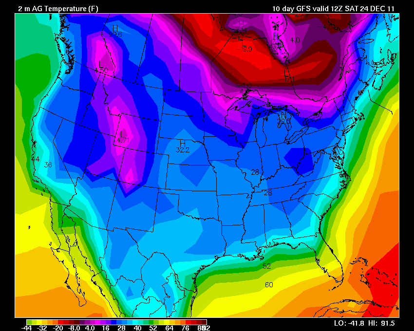
 And here are the temperature maps - brrrr
.

.

.
AND I promised you we would take a look at Christmas Eve and Christmas Day
.
Here is what the GFS is showing - again this is a still quite a few days away. I call this fantasy land for models because their accuracy beyond day 4 or 5 is very low. Let's monitor it each day or two and see where it goes. Again maps are from www.wright-weather.com and click the image for full view size.
.
.Check back in again tomorrow - let's see how it has changed. We will ride the GFS roller-coaster together!
.
Latest maps from www.wright-weather.com - shows the storm and temperatures. I will keep the chances for a white Christmas at 10% - no change
.
Click images for real view size - dates can be viewed at the top of each image - first three are surface maps - precipitation. The last three maps are temperatures.
.
Today's data shows COLD for Christmas Eve and Christmas Day - just a chance for light rain or snow showers. The GFS has taken away the big system. However, models tend to lose storms in this time frame - will need to continue to monitor and see what happens. The big change today is much colder temps on the long range maps.
.
I believe the storm could be further south and stronger than today's models indicate. Stay tuned!
.
Click image for real view size
.
.

.
.

.
Now is a GREAT time to buy a NOAA All Hazards Weather Radio. Better to have one before storms strike than to be without one during an event. I recommend the Midland Model 300 NOAA All Hazards Weather Radio - that is what I use here at my house!
.
Meteorologist Beau DodsonMcCracken County Office of Emergency Management
.

.
Beau Dodson Weather - Facebook
.

To view all watches and warnings in Illinois - Click Here
To view all watches and warnings in Kentucky - Click Here
To view all watches and warnings in Missouri - Click Here
To view all watches and warnings in Tennessee - Click Here
.
All other states- Click Here
.
For the latest watches and warnings please visit your local National Weather Service Office web-site.
http://www.weather.gov/organization.php
.
.
Remember most of these maps can be viewed straight off of the Weather Observatory Web-Site
.

.
No comments:
Post a Comment