.
For more frequent updates check out the weather Facebook page - click here and hit like at the top of the page.
.
This page is best viewed with Mozilla Firefox. There could be issues with spacing on Internet Explorer
.

.
This forecast covers far southern Illinois, southeast Missouri, southwest Indiana, western Kentucky, and northwest Tennessee - for your local town/area - click here
.
Here are my current personal forecast thoughts for far southern Illinois and western Kentucky...
.
Thursday night: Mostly clear and cold early - then an increase in clouds late. Some freezing fog possible in some areas.
Below normal temperatures
Lows: in the middle to upper 20s | Normal lows for this time of the year are around 30 degrees.Below normal temperatures
Wind: Northwest winds at 5 mph.
Precipitation probability - 0% | Rainfall totals: 0"
Confidence in this forecast is very high
.
Friday: A mix of sun and clouds. Cold. A few flurries possible - especially the northern half of the region.
Below normal temperatures.
Highs: around 39 degrees. | Normal highs for this time of the year are around 48 degrees.Below normal temperatures.
Wind: North winds at 10 mph
Precipitation probability - 0% | Rainfall totals: 0"
Confidence in this forecast is very high
.
Friday night: Clearing and cold. Coldest air of the season thus far.
Below normal temperatures
Below normal temperatures
Lows: in the upper teens and lower 20s | Normal lows for this time of the year are around 30 degrees.
Wind: Calm winds
Precipitation probability - 0% | Rainfall totals: 0"
Confidence in this forecast is very high
Wind: Calm winds
Precipitation probability - 0% | Rainfall totals: 0"
Confidence in this forecast is very high
.
Saturday: Mostly sunny skies.
Below normal temperatures.
Highs: around 37 degrees | Normal highs for this time of the year are around 48 degrees.Wind: North winds at 5-10 mph
Precipitation probability - 0% | Rainfall totals: 0"
.
.
Don't forget to sign up for the severe weather "heads up" email list - I usually email everyone before a big event - severe weather or winter storms - ice storms. Click here to join
.

.

Please avoid flooded roadways. Can't rule out some freezing fog during the overnight hours and early morning hours - freezing fog is fog that occurs when temperatures are below freezing. This can cause some slick spots on area roadways.

Please avoid flooded roadways. Watch for fog.
.

No wild cards in this forecast.
.
.

.
Tweaked temperatures
.

.
Forecast for your local town/city - Click Here
.
..
Join me on Facebook for more frequent updates on the weather in our local areaClick Here.
.
---

The forecast for severe or extreme weather for the next 24 hours
.
The McCracken County Office of Emergency Management reminds you that owning a NOAA All Hazards Weather Radio is the best way to receive notifications of severe weather watches and warnings.
.
Remember that the National Weather Service defines a severe thunderstorm as one that produces 58 mph winds or higher, hail 1" in size or larger, and/or a tornado. More information with some slides concerning reporting severe weather - click here
.
For the most up to date severe weather outlooks - click here.
or
Visit the Storm Prediction Center's web-site - click here
.
Thursday night: Severe weather is not anticipated. Freezing fog can't be ruled out.
Thursday night: Will there be a chance for non-severe thunderstorms? No
.
.
Thursday night: Severe weather is not anticipated. Freezing fog can't be ruled out.
Thursday night: Will there be a chance for non-severe thunderstorms? No
.
Friday: Severe weather is not anticipated. Morning freezing fog possible - some light flurries possible - especially over the northern half of the area.
Friday: Will there be a chance for non-severe thunderstorms? No
.Friday: Will there be a chance for non-severe thunderstorms? No
Friday night : Severe weather is not anticipated. No snow or ice.
Friday night: Will there be a chance for non-severe thunderstorms? No
.
Saturday: Severe weather is not anticipated. No snow or ice.
Saturday: Will there be a risk for non-severe thunderstorms? No
.
Saturday: Will there be a risk for non-severe thunderstorms? No
.

.
To view all watches and warnings in IL - Click Here
To view all watches and warnings in KY - Click Here
To view all watches and warnings in MO - Click Here
To view all watches and warnings in TN - Click Here
All other states- Click Here
To view all watches and warnings in IL - Click Here
To view all watches and warnings in KY - Click Here
To view all watches and warnings in MO - Click Here
To view all watches and warnings in TN - Click Here
All other states- Click Here
.
The links above are interactive and you can move around the United States by simply clicking on the national map - or from the pull down menu where it says regions and US States.
.
To view the interactive map - click here.
.
To view the interactive map - click here.
.
.

.
.
HEADLINE: Below normal temperatures continue to be the rule. Some freezing fog and mist developed last night over some of our counties.
.
There will be a chance for some fog again tonight. With temperatures below freezing this could mean slick spots on some roadways, bridges, and overpasses. Just use some extra care if fog forms.
.
The weather map for tonight into Friday night - some light snow to our north as a system passes by. Flurries could reach as far south as our far northern counties. Light event - for areas to our north.
.


.
Friday will be COLD - check out these high temperatures - BRRRRRR
.

.
The coldest air of the season will arrive on Friday night with temperatures in the teens and lower 20s across the region.
.
Here is the low temperature map for Saturday morning - BRRRRRR

.
Although we may have a few quiet days ahead of us (thankfully) - it isn't going to stay that way. An active pattern is going to develop later next week and could continue through the rest of the month. We will see swings in temperatures with each passing storm system - typically we warm up ahead of a storm system and cool down behind them.
.
The system around the 14th-18th could produce locally heavy rain in the Ohio and Tennessee Valleys.
.
Check out the latest six to ten day precipitation outlook - we are in dark green. ABOVE normal precipitation for next Tuesday through Saturday - hmmm - just what we DON'T need.
.
 .
.
This next map shows you the 8 to 14 day precipitation outlook - AGAIN wet. A pattern we don't want to see stick around much longer. We need to get the rivers down a bit before spring.
.
 .
.
And finally one more map for you to digest - the SEASONAL precipitation outlook - through February - again WET with above normal precipitation. No doubt some of that will be snow.
.
 .
.
Here is the January through March map followed by the February through April map - do you get the general idea? Don't cancel the flood insurance.
.
 .
.

,
The big question on everyone's mind is whether or not we are going to see some snow in the coming weeks. I can't imagine that this pattern will continue much longer without some snow. The system for next week (Wednesday-Thursday) looks wet - with a good chance for rain (perhaps even some thunderstorms). Then another three systems possible before the end of the month - perhaps four systems. It won't be a boring pattern.
.
Bottom line...
.
We will just have to monitor each storm to see where it tracks and whether we will be on the cold side or warm side. This will determine precipitation type - obviously. I don't want to get your hopes up about snow - all I can tell you is that it will be at least an active weather pattern.
.
Do you think that our precipitation has been above normal so far this month? You would be correct. Check out these two maps showing the percent of normal rainfall. You can see that parts of our region are anywhere from 400-600% ABOVE normal in the precipitation department. Par for the course this year. The wettest year on record for our region.
.
.
 .
.
 .
.
The above map shows you the departure from normals - precipitation. Obviously we are well above normal - as much as 2-4" above normal - thus far. This month isn't over - we are just getting started.
.
This map shows how much rain we have received over the past 7 days. Click on image for full view size.
.

.
Rivers will be on the rise - see the latest lake and river stage forecasts - here.
.
HEADLINE: Below normal temperatures continue to be the rule. Some freezing fog and mist developed last night over some of our counties.
.
There will be a chance for some fog again tonight. With temperatures below freezing this could mean slick spots on some roadways, bridges, and overpasses. Just use some extra care if fog forms.
.
The weather map for tonight into Friday night - some light snow to our north as a system passes by. Flurries could reach as far south as our far northern counties. Light event - for areas to our north.
.
.
Friday will be COLD - check out these high temperatures - BRRRRRR
.
.
The coldest air of the season will arrive on Friday night with temperatures in the teens and lower 20s across the region.
.
Here is the low temperature map for Saturday morning - BRRRRRR
.
.
Although we may have a few quiet days ahead of us (thankfully) - it isn't going to stay that way. An active pattern is going to develop later next week and could continue through the rest of the month. We will see swings in temperatures with each passing storm system - typically we warm up ahead of a storm system and cool down behind them.
.
The system around the 14th-18th could produce locally heavy rain in the Ohio and Tennessee Valleys.
.
Check out the latest six to ten day precipitation outlook - we are in dark green. ABOVE normal precipitation for next Tuesday through Saturday - hmmm - just what we DON'T need.
.
This next map shows you the 8 to 14 day precipitation outlook - AGAIN wet. A pattern we don't want to see stick around much longer. We need to get the rivers down a bit before spring.
.
And finally one more map for you to digest - the SEASONAL precipitation outlook - through February - again WET with above normal precipitation. No doubt some of that will be snow.
.
Here is the January through March map followed by the February through April map - do you get the general idea? Don't cancel the flood insurance.
.
,
The big question on everyone's mind is whether or not we are going to see some snow in the coming weeks. I can't imagine that this pattern will continue much longer without some snow. The system for next week (Wednesday-Thursday) looks wet - with a good chance for rain (perhaps even some thunderstorms). Then another three systems possible before the end of the month - perhaps four systems. It won't be a boring pattern.
.
Bottom line...
.
We will just have to monitor each storm to see where it tracks and whether we will be on the cold side or warm side. This will determine precipitation type - obviously. I don't want to get your hopes up about snow - all I can tell you is that it will be at least an active weather pattern.
.
Do you think that our precipitation has been above normal so far this month? You would be correct. Check out these two maps showing the percent of normal rainfall. You can see that parts of our region are anywhere from 400-600% ABOVE normal in the precipitation department. Par for the course this year. The wettest year on record for our region.
.
.
The above map shows you the departure from normals - precipitation. Obviously we are well above normal - as much as 2-4" above normal - thus far. This month isn't over - we are just getting started.
.
This map shows how much rain we have received over the past 7 days. Click on image for full view size.
.

.
Rivers will be on the rise - see the latest lake and river stage forecasts - here.
.
We have a TON of new weather maps on the Weather Observatory web-site - these include temperatures, wind speed, dew points, heat index, barometric pressure, predicted rainfall, climate forecast, medium and long range maps, forecasts and more! Click here
.
.
-----------------------------
.

.
Let's check out the how much rain is forecast to fall over the next 72 hours. This map gives you a general broad brushed idea of what can be expected. Remember the scale is at the top of the map.
.
If you would like to view the most up to date 24, 48, 72, and 120 hour precipitation forecast maps then click here.
.
If you would like to view the most up to date 24, 48, 72, and 120 hour precipitation forecast maps then click here.
.

.

.
You can also now view the probability of X amount of rain (you pick the value on the web-site) in a six hour period of time. Those maps can be viewed here.
.
You can view drought maps on the Weather Observatory web-site by clicking here.
.

You can also now view the probability of X amount of rain (you pick the value on the web-site) in a six hour period of time. Those maps can be viewed here.
.
You can view drought maps on the Weather Observatory web-site by clicking here.
.
.
.
Significant snow is not in our forecast through the weekend. Could be a few flurries or light snow (especially over the northern half of the region) as a system passes to our north - into Friday.
.
Significant snow is not in our forecast through the weekend. Could be a few flurries or light snow (especially over the northern half of the region) as a system passes to our north - into Friday.
.
Enhanced snowfall interactive forecast maps . You can choose your total snowfall amounts above the map - time frame, as well- click here
.
Snowfall forecast maps - these are interactive maps. You can choose your total snowfall amounts above the map - time frame, as well - click here
Enhanced snowfall interactive forecast maps . You can choose your total snowfall amounts above the map - time frame, as well- click here
.
Snowfall forecast maps - these are interactive maps. You can choose your total snowfall amounts above the map - time frame, as well - click here
.
If you are looking for wintry precipitation - click here.
.
.

.
You can view the upcoming days high temperature and low temperature forecasts by clicking here - choose the day - click on your state to zoom in
You can view the upcoming days high temperature and low temperature forecasts by clicking here - choose the day - click on your state to zoom in
.
 .
. We have a number of new radars available on our Weather Observatory web-site!
---
We now offer St Louis, Mt Vernon, Evansville, Poplar Bluff, Cape Girardeau, Marion, Paducah, Hopkinsville, and Dyersburg Interactive City Radars. We also have the two regional radars and now offer you three GR Earth radars.
http://www.weatherobservatory.com/weather-radar.htm---
---
We also have a new interactive radar - you can view that radar by clicking here.
.
Want to learn more about how to use our radars? I made a how to video with more information
Click here - http://www.youtube.com/watch?v=bfLa0hI3adU
.
.
.
.
---

.
Date Range: December 1st - December 11th
Event: Mostly below normal to much below normal temperatures. Active pattern.
Severe Risk: Not expecting severe weather.
Frozen Precipitation Risk:
Details: Cold air - several shots of below normal temperatures.
Confidence in my forecast: High
.
Date Range: December 11th - December 18th
Event: Swings in temperatures.
Severe Risk:
Frozen Precipitation Risk: One or two precipitation events possible - watching the 14th-16th time period for one event - right now data is showing a rain event. Locally heavy rain will be possible.
Details: Transition period with swings from above to well below normal temperatures. A chance for one or two precipitation events
Confidence in my forecast. Very High
.
.
Date Range: December 19th - December 23rd
Event: Precipitation event - significant storm system possible.
Severe Risk: Unknown
Frozen Precipitation Risk: Unknown
Details: A more significant storm system possible in or near our region. Followed by another large blast of cold air.
Confidence in my forecast. Low
.
.
Date Range: December 24th-29th
Event: Significant storm system in the Missouri/Ohio/Tennessee Valley
Severe Risk:
Frozen Precipitation Risk:
Details: Potential precipitation event.
Confidence in my forecast: Low
.
.
Remember that as a general policy, in the long range outlook, I will NOT mention severe thunderstorms more than 72 hours in advance. I will mention thunderstorm risks and I will give as many details as possible. The word severe will be reserved for the short range forecast.
.
-----------------------------
.
1. Calm weather into the weekend - then the next storm that we zero in on will be around the 14th-16th - we had that system in our long range forecast for quite some time. The big question centered around precipitation type - would it be rain or snow?
.
Well - bad news for snow lovers - the data is trending towards showers and thunderstorms. Still some time for changes - but the trend is not your friend (if you like snow). Will continue to monitor.
.
Rainfall amounts with the system next week should be in the 0.50-1.00 range. Could even be some thunderstorms - bit too soon to know for sure. Another locally heavy rain event can't be ruled out next week in or near our local counties - the front may hang up (once again in our region). This will need to be monitored.
.
Temperatures will be on the upswing ahead of the storm (remember if the low passes to our north that it pulls warm air northward - if the low passes to our south then it pulls down cold air from the north).
.
Here is what the GFS Model is showing for this storm - don't take this as gospel - not this far out. But it does give you an idea of what I am looking at.
.
You can see the deep area of low pressure passing to our west - the pink and blue areas are rain and thunderstorms. The second image shows you temperatures - see how the system pulls warm air northward in advance of the cold front - then behind the storm see how it pulls down cold air.
.
These images are from www.wright-weather.com - my favorite site for model data
.
Click images for real size view
.

.

.
Here is what the precipitation map might look like next Wednesday.
.

Now what about Christmas? Everyone wants to know about Christmas. Is it too soon to talk about rain or snow chances? Yes! It is too soon - but that doesn't mean we can't speculate.
.
The LONG range - fantasy land GFS is showing lots of cold air but with a deep storm forming to our west. Could this mean precipitation around the 24th-27th? It could. We have been talking about a large storm for the end of the month - might have to push it up a few days.
.
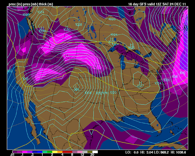
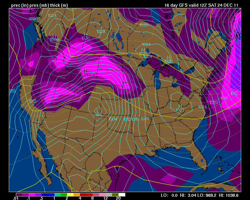
Here is what the GFS is showing - again this is a LONG LONG way off - I call this fantasy land for models because their accuracy beyond day 4 or 5 is very low. Let's monitor it each day or two and see where it goes. Again maps are from Wright-Weather and click the image for full view size - the first image is the surface map and the second image is the temperature map
.
See the storm forming to the west? Also note all the cold air. Things that make meteorologists go hmmmm (yes that is a tease).
.
Check back in again tomorrow - let's see how it has changed. We will ride this roller-coaster together!
.
.


.
Here is what the precipitation map might look like next Wednesday.
.
Now what about Christmas? Everyone wants to know about Christmas. Is it too soon to talk about rain or snow chances? Yes! It is too soon - but that doesn't mean we can't speculate.
.
The LONG range - fantasy land GFS is showing lots of cold air but with a deep storm forming to our west. Could this mean precipitation around the 24th-27th? It could. We have been talking about a large storm for the end of the month - might have to push it up a few days.
.
Here is what the GFS is showing - again this is a LONG LONG way off - I call this fantasy land for models because their accuracy beyond day 4 or 5 is very low. Let's monitor it each day or two and see where it goes. Again maps are from Wright-Weather and click the image for full view size - the first image is the surface map and the second image is the temperature map
.
See the storm forming to the west? Also note all the cold air. Things that make meteorologists go hmmmm (yes that is a tease).
.
Check back in again tomorrow - let's see how it has changed. We will ride this roller-coaster together!
.
.

Now is a GREAT time to buy a NOAA All Hazards Weather Radio. Better to have one before storms strike than to be without one during an event. I recommend the Midland Model 300 NOAA All Hazards Weather Radio - that is what I use here at my house!
.
Meteorologist Beau DodsonMcCracken County Office of Emergency Management
.

.
Beau Dodson Weather - Facebook
.

To view all watches and warnings in Illinois - Click Here
To view all watches and warnings in Kentucky - Click Here
To view all watches and warnings in Missouri - Click Here
To view all watches and warnings in Tennessee - Click Here
.
All other states- Click Here
.
For the latest watches and warnings please visit your local National Weather Service Office web-site.
http://www.weather.gov/organization.php
.
.
Remember most of these maps can be viewed straight off of the Weather Observatory Web-Site
.

.
No comments:
Post a Comment