.
For more frequent updates check out the weather Facebook page - click here and hit like at the top of the page.
.
This page is best viewed with Mozilla Firefox. There could be issues with spacing on Internet Explorer
.

.
This forecast covers far southern Illinois, southeast Missouri, southwest Indiana, western Kentucky, and northwest Tennessee - for your local town/area - click here
.
Here are my current personal forecast thoughts for far southern Illinois and western Kentucky...
.
Monday night: Mostly cloudy with showers developing - a chance for a thunderstorm.
Above normal temperatures
Lows: in the middle 40s | Normal lows for this time of the year are around 28 degrees.Above normal temperatures
Wind: Easterly at 5-10 mph.
Precipitation probability - 60% late | Rainfall totals: 0.10"-0.20"
Confidence in this forecast is very high
.
Tuesday: Cloudy with showers and thunderstorms - especially the first half of the day. Then scattered showers and thunderstorms possible in the afternoon. Thunder more likely in Kentucky vs areas to the west.
Highs: lower to middle 50s | Normal highs for this time of the year are around 46 degrees.Above normal temperatures
Wind: Southerly winds at 10 mph
Precipitation probability - 80% | Rainfall totals: 0.20"-0.40"
Confidence in this forecast is very high
.
Tuesday night: Cloudy with showers possible.
Above normal temperatures
Lows: steady temperatures in the 50s | Normal lows for this time of the year are around 28 degrees.
Wind: Southwest winds 10-20 mph and gusty
Precipitation probability - 60% | Rainfall totals: 0.10-0.30"
Confidence in this forecast is very high
Wind: Southwest winds 10-20 mph and gusty
Precipitation probability - 60% | Rainfall totals: 0.10-0.30"
Confidence in this forecast is very high
.
Wednesday: Cloudy with a chance for light showers. Turning colder.
Below normal temperatures
Highs: falling into the 40s | Normal highs for this time of the year are around 46 degrees.Wind: Westerly winds at 5-15 mph - gusts to 20 mph
Precipitation probability - 30% | Rainfall totals: 0.10"
.
.
Don't forget to sign up for the severe weather "heads up" email list - I usually email everyone before a big event - severe weather or winter storms - ice storms. Click here to join
.

.


Forecast for your local town/city - Click Here
.
..
Join me on Facebook for more frequent updates on the weather in our local areaClick Here.
.
---

The forecast for severe or extreme weather for the next 24 hours
.
The McCracken County Office of Emergency Management reminds you that owning a NOAA All Hazards Weather Radio is the best way to receive notifications of severe weather watches and warnings.
.
Remember that the National Weather Service defines a severe thunderstorm as one that produces 58 mph winds or higher, hail 1" in size or larger, and/or a tornado. More information with some slides concerning reporting severe weather - click here
.
For the most up to date severe weather outlooks - click here.
or
Visit the Storm Prediction Center's web-site - click here
.
Monday night: Severe weather is not anticipated. No snow or ice.
Monday night: Will there be a chance for non-severe thunderstorms? Not likely
.
.
Monday night: Severe weather is not anticipated. No snow or ice.
Monday night: Will there be a chance for non-severe thunderstorms? Not likely
.
Tuesday: Severe weather is not anticipated. No snow or ice.
Tuesday: Will there be a chance for non-severe thunderstorms? A rumble of thunder possible
.Tuesday: Will there be a chance for non-severe thunderstorms? A rumble of thunder possible
Tuesday night : Severe weather is not anticipated. No snow or ice.
Tuesday night: Will there be a chance for non-severe thunderstorms? No
.
Wednesday: Severe weather is not anticipated. No snow or ice.
Wednesday: Will there be a risk for non-severe thunderstorms? No
.
Wednesday: Will there be a risk for non-severe thunderstorms? No
.

.
To view all watches and warnings in IL - Click Here
To view all watches and warnings in KY - Click Here
To view all watches and warnings in MO - Click Here
To view all watches and warnings in TN - Click Here
All other states- Click Here
To view all watches and warnings in IL - Click Here
To view all watches and warnings in KY - Click Here
To view all watches and warnings in MO - Click Here
To view all watches and warnings in TN - Click Here
All other states- Click Here
.
The links above are interactive and you can move around the United States by simply clicking on the national map - or from the pull down menu where it says regions and US States.
.
To view the interactive map - click here.
.
To view the interactive map - click here.
.
.

.
.
HEADLINE: Monday brought a cloudy day across the region - a bit dreary. Cool temperatures with some scattered showers from time to time - especially true over southeast Missouri and southern Illinois.
.
Here is the Monday evening satellite image - you can see the big storm system winding up to our west.
.
 .
.
And CHECK OUT RADAR! Wow - big storm system - plenty of snow to our west and lots of showers and thunderstorms ahead of the cold front. Click image for real view size.
.

The red area on this map is where BLIZZARD WARNINGS have been issued! WHITE CHRISTMAS for portions of Oklahoma and Kansas - no doubt about it!
.

.
Rain will develop late tonight and cover the area on Tuesday. A few rumbles of thunder will also be possible. Rainfall totals should be in the 0.40-0.80" range across the region.
.
Severe weather is not anticipated.
.
Here is the future-cast cloud cover and precipitation maps for tonight into Tuesday. Time stamps at the top of each image.
.


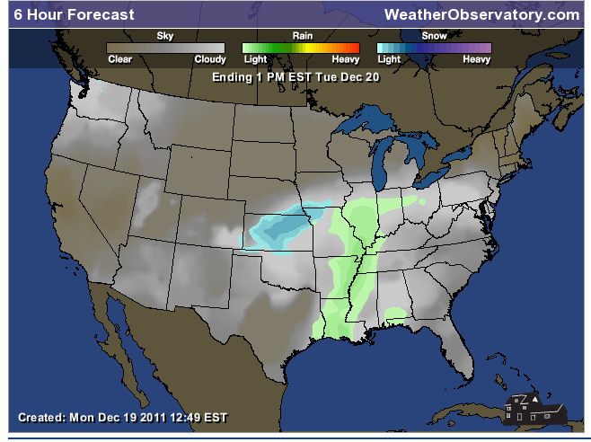

.
This same storm system that will bring rain to our region will bring a BLIZZARD to portions of Oklahoma and Kansas. Heavy wind driven snow.
.
The next storm system will bring us a good chance of rain on Thursday - right now it appears that it will be warm enough for all rain.
.
See the long range for Friday through the holiday weekend.
.
.
Probabilities for rainfall totals - Tonight through Wednesday - entire event
There will be a 100% chance of 0.20-0.50" of rain falling - certain chance - an ten out of ten chance
There will be a 70% chance of 0.50-0.75" of rain falling - good chance of occurring - a seven out of ten chance
There will be a 50% chance of 0.75-1.00" of rain falling - medium chance of occurring- a five out of ten chance
There will be a 30% chance of 1.00-1.50" of rain falling - a chance of occurring - a three out of ten chance
There will be a 5% chance of 1.50-2.50" of rain falling
.
Rivers will remain high - see the latest lake and river stage forecasts - here.
.
HEADLINE: Monday brought a cloudy day across the region - a bit dreary. Cool temperatures with some scattered showers from time to time - especially true over southeast Missouri and southern Illinois.
.
Here is the Monday evening satellite image - you can see the big storm system winding up to our west.
.
And CHECK OUT RADAR! Wow - big storm system - plenty of snow to our west and lots of showers and thunderstorms ahead of the cold front. Click image for real view size.
.

The red area on this map is where BLIZZARD WARNINGS have been issued! WHITE CHRISTMAS for portions of Oklahoma and Kansas - no doubt about it!
.
.
Rain will develop late tonight and cover the area on Tuesday. A few rumbles of thunder will also be possible. Rainfall totals should be in the 0.40-0.80" range across the region.
.
Severe weather is not anticipated.
.
Here is the future-cast cloud cover and precipitation maps for tonight into Tuesday. Time stamps at the top of each image.
.
.
This same storm system that will bring rain to our region will bring a BLIZZARD to portions of Oklahoma and Kansas. Heavy wind driven snow.
.
The next storm system will bring us a good chance of rain on Thursday - right now it appears that it will be warm enough for all rain.
.
See the long range for Friday through the holiday weekend.
.
.
Probabilities for rainfall totals - Tonight through Wednesday - entire event
There will be a 100% chance of 0.20-0.50" of rain falling - certain chance - an ten out of ten chance
There will be a 70% chance of 0.50-0.75" of rain falling - good chance of occurring - a seven out of ten chance
There will be a 50% chance of 0.75-1.00" of rain falling - medium chance of occurring- a five out of ten chance
There will be a 30% chance of 1.00-1.50" of rain falling - a chance of occurring - a three out of ten chance
There will be a 5% chance of 1.50-2.50" of rain falling
.
Rivers will remain high - see the latest lake and river stage forecasts - here.
.
We have a TON of new weather maps on the Weather Observatory web-site - these include temperatures, wind speed, dew points, heat index, barometric pressure, predicted rainfall, climate forecast, medium and long range maps, forecasts and more! Click here
.
.
-----------------------------
.

.
Let's check out the how much rain is forecast to fall over the next 72 hours. This map gives you a general broad brushed idea of what can be expected. Remember the scale is at the top of the map.
.
If you would like to view the most up to date 24, 48, 72, and 120 hour precipitation forecast maps then click here.
.
If you would like to view the most up to date 24, 48, 72, and 120 hour precipitation forecast maps then click here.
.

.

.
You can also now view the probability of X amount of rain (you pick the value on the web-site) in a six hour period of time. Those maps can be viewed here.
.
You can view drought maps on the Weather Observatory web-site by clicking here.
.

You can also now view the probability of X amount of rain (you pick the value on the web-site) in a six hour period of time. Those maps can be viewed here.
.
You can view drought maps on the Weather Observatory web-site by clicking here.
.
.
.
No snow in our forecast...
.
No snow in our forecast...
.
Enhanced snowfall interactive forecast maps . You can choose your total snowfall amounts above the map - time frame, as well- click here
.
Snowfall forecast maps - these are interactive maps. You can choose your total snowfall amounts above the map - time frame, as well - click here
Enhanced snowfall interactive forecast maps . You can choose your total snowfall amounts above the map - time frame, as well- click here
.
Snowfall forecast maps - these are interactive maps. You can choose your total snowfall amounts above the map - time frame, as well - click here
.
If you are looking for wintry precipitation - click here.
.
.

.
You can view the upcoming days high temperature and low temperature forecasts by clicking here - choose the day - click on your state to zoom in
You can view the upcoming days high temperature and low temperature forecasts by clicking here - choose the day - click on your state to zoom in
.
 .
. We have a number of new radars available on our Weather Observatory web-site!
---
We now offer St Louis, Mt Vernon, Evansville, Poplar Bluff, Cape Girardeau, Marion, Paducah, Hopkinsville, and Dyersburg Interactive City Radars. We also have the two regional radars and now offer you three GR Earth radars.
http://www.weatherobservatory.com/weather-radar.htm---
---
We also have a new interactive radar - you can view that radar by clicking here.
.
Want to learn more about how to use our radars? I made a how to video with more information
Click here - http://www.youtube.com/watch?v=bfLa0hI3adU
.
.
.
.
---

.
.
Date Range: December 18th - December 24th
Event: Precipitation events
Severe Risk:
Frozen Precipitation Risk:
Details: A more significant storm system possible in or near our region. A mix of above and below normal temperatures. Rainfall of 0.40-0.80" possible with the Monday/Tuesday system - another chance for precipitation around Thursday/Friday
Confidence in my forecast. Very High
.
.
Date Range: December 25th-29th
Event: Significant storm system in the Missouri/Ohio/Tennessee Valley - more below normal temperatures days vs above normal days.
Severe Risk:
Frozen Precipitation Risk:
Details: Potential precipitation events.
Confidence in my forecast: Medium
.
.
Date Range: December 26th-January 15th
Event: Potential for bitterly cold air masses mixed in with above normal temperatures
Severe Risk:
Frozen Precipitation Risk: 3-5 potential precipitation events
Details: Potential precipitation event and perhaps below normal temperatures. Uncertainty surrounds the NAO going negative - some blocking in the Atlantic.
Confidence in my forecast: Low
.
.
Remember that as a general policy, in the long range outlook, I will NOT mention severe thunderstorms more than 72 hours in advance. I will mention thunderstorm risks and I will give as many details as possible. The word severe will be reserved for the short range forecast.
.
-----------------------------
.
1. The long range brings more unsettled weather with a couple of disturbances moving through the fast flow. One will arrive on Thursday - this will bring rain. The next one will arrive on Friday and Saturday - that system could bring a mix of rain and snow to the area.
.
Accumulations if any should be light.
.
Here is the Friday system on the NAM model - from www.wright-weather.com
.
Click image for larger size - this is the future-cast radar image - again light precipitation and temperatures will be marginal for snow - snow/rain mix.
.

.
.
Here is what the GFS is showing - for the bigger system on the 25th and 26th - unfortunately almost all of today's data takes the system so far south and east that it does not impact our region - thus diminishing our chances for snow on Christmas Day. Still a few days off - will monitor - I do not trust the models right now because they are not handling the systems very well.
.
 .
.
Check back in again tomorrow - let's see how it has changed. We will ride the GFS roller-coaster together!
.
Click images for real view size - dates/times can be viewed at the top of each image . Click image for real view size (12z = around 6 to 7 am and 0z = around 6 or 7 pm)
.
80% chance we do not have a White Christmas - 20% chance of a White Christmas for portions of our region - hopes would have to be on the Friday night and Saturday system first and then the potential southern system - which the models nearly completely lost today. Let's see what tomorrow brings - Tuesday.
.

.
Accumulations if any should be light.
.
Here is the Friday system on the NAM model - from www.wright-weather.com
.
Click image for larger size - this is the future-cast radar image - again light precipitation and temperatures will be marginal for snow - snow/rain mix.
.

.
.
Here is what the GFS is showing - for the bigger system on the 25th and 26th - unfortunately almost all of today's data takes the system so far south and east that it does not impact our region - thus diminishing our chances for snow on Christmas Day. Still a few days off - will monitor - I do not trust the models right now because they are not handling the systems very well.
.
.Check back in again tomorrow - let's see how it has changed. We will ride the GFS roller-coaster together!
.
Click images for real view size - dates/times can be viewed at the top of each image . Click image for real view size (12z = around 6 to 7 am and 0z = around 6 or 7 pm)
.
80% chance we do not have a White Christmas - 20% chance of a White Christmas for portions of our region - hopes would have to be on the Friday night and Saturday system first and then the potential southern system - which the models nearly completely lost today. Let's see what tomorrow brings - Tuesday.
.

.
Now is a GREAT time to buy a NOAA All Hazards Weather Radio. Better to have one before storms strike than to be without one during an event. I recommend the Midland Model 300 NOAA All Hazards Weather Radio - that is what I use here at my house!
.
Meteorologist Beau DodsonMcCracken County Office of Emergency Management
.

.
Beau Dodson Weather - Facebook
.

To view all watches and warnings in Illinois - Click Here
To view all watches and warnings in Kentucky - Click Here
To view all watches and warnings in Missouri - Click Here
To view all watches and warnings in Tennessee - Click Here
.
All other states- Click Here
.
For the latest watches and warnings please visit your local National Weather Service Office web-site.
http://www.weather.gov/organization.php
.
.
Remember most of these maps can be viewed straight off of the Weather Observatory Web-Site
.

.
No comments:
Post a Comment