October 31, 2010: Happy Halloween - tracking Tomas

October 31, 2010:

"Bottom Line It For Me Beau"

Severe or extreme weather risk for today, tonight, and tomorrow:  0%


Nice weather.  Winds will be light.  Highs in the upper 60s and lows tonight will be in the 36-41 degree range.  Fire danger remains high.  

For your return to work on Monday - Partly sunny with highs in the middle 60s.

----------------------------------------------

Good morning everyone.  Happy Halloween!  The weather has been wonderful over the last couple of days.  A bit chilly at times - but can complain about that?

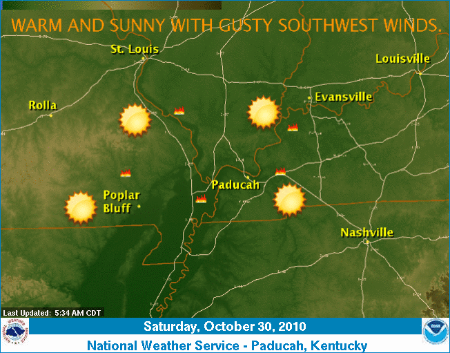
Your daily weather map:


The Paducah, Kentucky National Weather Service Office put out this map (centering in on our counties).  You can see a dry cold front moving through our local counties.


I have friends in Ontario this morning that are reporting snowflakes!  Winter is knocking!

Dry conditions will continue over the coming days - please refrain from outside burning.  Some burn bans have been lifted, however, conditions have barely changed - fire danger remains high.

The weather will be nice today.  A few clouds on Monday and mostly cloudy as we move into Monday night and Tuesday.  A few showers across the southern portion of our area.

No extreme weather is on the map (for our region at least).  Some chilly nights and cool days are ahead of us.  It is November now (well one more day).  Normal highs for this time of the year are around 64 degrees and the normal low for the Paducah vicinity is around 41.

Let's take a look at a forecast map for this coming Saturday (the 6th of November).  This map is showing you what the GFS believes temperatures will be - blue is below normal temperatures and red/orange is above normal temperatues.  You can see the forecast model is predicting a chilly weekend (next weekend).  There are even hints of a chance of a few snow flakes across portions of the Ohio Valley towards Friday/Saturday.


We have been averaging above normal - overall - for the past month.  I will post the Sept and October verification maps (for my fall forecast) tomorrow.

Your seven day forecast can be viewed by clicking here.

The next big storm on the horizon is quite a bit days away.  Perhaps after the 9th or 10th of the month.

Hurricane Tomas continues to move through the Caribbean.  Interests in the Caribbean should keep an eye on the eventual track of this system.  It appears that Tomas will make a turn to the north and should eventually move towards Cuba/Haiti.  In between perhaps. 

The web-site for the National Hurricane Center can be found by clicking here.

A look at Tomas on satellite this morning:


- Meteorologist Beau Dodson
McCracken County Office of Emergency Management

For the latest watches and warnings please visit your local National Weather Service Office http://www.weather.gov/organization.php

October 30, 2010: Red flag warning - otherwise nice weekend!

October 30, 2010

Happy Halloween Weekend!!!!  

Well, we thought it would be a nice weekend a week or so ago and it appears that forecast is on track!  Thankfully, because there are a ton of outdoor activities tonight and tomorrow night.  I will be attending the Zombie Walk in downtown Paducah!  Looking forward to the fun.

I had thought we were moving towards a much more active pattern - I was wrong about that.  That was becoming more and more obvious over the last few days.  The models have a difficult time during the transition of seasons.  I should have kept the "uncertainty rule" in mind when buying into the long range data.

Seems like we just can't win around here when it comes to rain.  We desperately need a pattern shift.  I do believe it will come - La Nina is raging.  It is just a matter of time.  But - for now - dry weather will continue.  Let's hope we start to pick things up a bit as we move towards the middle/end of November.  That was the original thinking/forecast - so let's see how it goes.

A large and significant storm system is forecast to impact the east coast later this week (towards the end of the coming week).  We will have to keep an eye on this system.  

Your seven day forecast can be viewed by clicking here.  I recorded a low of 32.5 degrees this morning in the instrument shelter.  Some frost up and down my lane.

Some chilly days ahead of us - but not too bad.  I don't think anyone will be complaining. I am also watching a system for Tuesday night into Wednesday.  This system is forecast to develop along the Gulf Coast.  If it moves far enough north then we might need to add a few showers into the forecast.

Here is the Wednesday morning map - this map shows some clouds and lift over our region.  The hatched looking area is lift.  Some general lift along the Gulf Coast.  Expect there to be some showers and thunderstorms to our south and along the coast.  Something I will be keeping an eye on. 


The tropics are roaring their head again - click here for the latest on the new tropical storm and hurricane.

Tomas is probably the biggest concern.  This system will likely become a large hurricane.

Track path:


Above - Hurricane Tomas - heading into the Caribbean

For our region:

A RED FLAG WARNING is in effect for most of our area.  Fire departments are requesting that you please do not burn anything outside.  Fire conditions today will be high. More information on the red flag warning.  For a list of burn bans - click here.

Today's weather map:  As always, you can click on all the images on this page to make them larger.


Our local weather summary - above - issued by the Paducah, National Weather Service Office.

Let's take a look at some updated maps from the outbreak - there have been several more tornado reports added to the list.  Quite the event.  Thankfully I don't see any extreme weather in our near term pattern.


I will update the monthly outlook over the next few days.  October will end up with above normal temperatures and below normal precipitation - just as forecast!  Let's see if we can make it three in a row with the November forecast.

Couple of maps:

The departure for temperatures (all of the red/orange/yellow is above normal temps for the last 29 days)


On the above map - all the area in red/orange/yellow is below normal precipitation.  VERY dry.  More maps in the coming days.

One last set of maps - this is the jet stream position forecast for later this week (next Friday).  Notice the buckling jet - bringing air down from Canada into our region.  The second map is the GFS forecast for low temperatures next Friday night.  Appears to be quite chilly.  Click images, as always, for a larger view.


- Meteorologist Beau Dodson
McCracken County Office of Emergency Management

For the latest watches and warnings please visit your local National Weather Service Office http://www.weather.gov/organization.php

October 29, 2010: Welcome to brrrville

October 29, 2010:

Wow - did the forecast temperatures bust this morning - at least here at my place!  Colder than expected.  Loving it, though.  I am a fan of cold weather (well I am a fan of snow - cold weather is just part of the equation)!  Inside the instrument shelter - which is about 5-6' above the ground - I recorded a low of 22.5 degrees. 

Your morning weather map - click for larger view:


I am currently reading 26.4 degrees on the digital thermometer here at my place in Massac County.  Quite a bit colder than expected.  Also some thick fog outside my window.  Visibility is less than 1/2 mile at times.  Watch for the fog and possibly some patchy ice on bridges (from the fog).

It reached 27 in Carbondale, 24 in Mt Vernon, 27 in Evansville, 27 in Cape Girardeau, and 31 in Paducah (although I am still waiting on the final numbers - that gives you an idea of the temperatures around the area).

You can view current conditions and tower cams by clicking here.

Looking around the Ohio Valley - temperatures - click for larger image.


Ohio Valley Temperatures - from www.wright-weather.com

Your seven day forecast - click here.

Halloween weekend will be dry.  Coolish.  Highs in the 60s to near 70 and lows in the 40s (except for tonight - lots tonight in the 30s).  Nice for those who will be and out about at all of the fall festivities.  Enjoy!

Burn bans are still in effect.  Please don't burn brush or debris!  The fire departments would appreciate your efforts.  :)

The active pattern that I thought we were moving into is not materializing.  At least not for the next 7 days.  I guess we had a false start with that big storm last week.  I will take a deeper look at the long range data later this weekend.  There are still signals for some systems - past the near term forecast.  Will monitor.

- Meteorologist Beau Dodson
McCracken County Office of Emergency Management

For the latest watches and warnings please visit your local National Weather Service Office http://www.weather.gov/organization.php

Thursday, October 28, 2010: Drought maps - nice weather into the weekend

October 28, 2010

Good morning everyone!  Wow, what a beautiful day yesterday was.  And just look outside this morning - blue sky - fallish temperatures - moderate winds.  What is there not to love about this weather?  :)

Your seven day forecast can be viewed by clicking here.  Parts of our area are under a freeze watch and warning for tonight.  In case you have some sensitive plants - you might want to cover them.  Halloween weekend should be nice - I don't see any problems.

I am concerned that I am going to be wrong on the pattern becoming more active.  It appeared that would be the case - however there are definitely conflicting signals now.  We do have a couple of chances of rain next week - but just how beneficial the rain will be is certainly in question.  I will monitor! 

A total of 63 tornadoes have now been reported (preliminary numbers) from the outbreak a few days ago.  Many in the Ohio Valley and southeast United States.  Here are the latest maps from Monday into Wednesday.  Click for larger views.  You can view the storm summary sheet by clicking here.

Six tornadoes hit Kentucky (storm surveys ares till being conducted).  You can read more about the tornadoes by clicking here.

The maps below also show you how fortunate our region was.  Yes, there was some scattered damage - but it could have been a whole lot worse.  


Your daily weather map - from the National Weather Service


The nice weather will continue into the Halloween weekend.  The next chance for showers won't arrive until next week.  At one point it was looking as if we would have another big storm on Monday or Tuesday - however, the trends have been away from a big event.  This is bad news for those who need rain.  There are signals for better precipitation chances later next week - but even that is a bit uncertain.

We are still in drought.  Some areas did pick up some rain over the last 6-10 days.  As a matter of fact a lot of people received between 1 and 2 inches.  However, most of southern Illinois, southeast Missouri, and far western Kentucky picked up less than 1".  I recorded 0.39" here at my place.  A far cry from the expected rainfall totals.

Fire departments continue to ask everyone to please not burn brush or grass.  Click here for burn ban information (thanks NWS Paducah)

It does appear that both September and October will end up with above normal temperatures and below normal precipitation.  So, the fall forecast still appears on target.  We will have to see how November goes - I had expected a turn to stormier conditions as we moved into the middle of November.  I was thinking last week that we would  have to push that up even earlier - but those signals appeared to have changed.  So - once again - we will wait and see how everything unfolds.

Here are the latest drought maps:  You can read more about the drought at this site - click here.  As always with most of the images on this page - just click to make it larger.  (Some of these maps will have to be updated next week in order to factor in the recent rains)


The above map is the national view of the drought.  Deeper red is more severe - yellow is less severe drought.


Let's take a look at the official 8-14 day outlook from the NWS.


Temperature map above - leans towards normal to above normal temperatures.  This may be off some - because from what I can tell the ensembles and long range data indicates much of the eastern U.S. and our region would be below normal.  But - either way - nothing too unusual or extreme.


Precipitation is definitely in the below normal probabilities.  This means that the odds favor below normal precipitation.  Let's hope this is wrong.

Have a wonderful Thursday!

- Meteorologist Beau Dodson

McCracken County Office of Emergency Management

For the latest watches and warnings please visit your local National Weather Service Office http://www.weather.gov/organization.php

October 27, 2010: Historic storm - record low pressyre - storm damage

October 27, 2010

Good morning!

Today's weather map:


Wow, what an event.  Thankfully our region was spared major damage.  There were a lot of storm damage reports, however, it could have been much worse.  So, we should be thankful!

This was the deepest non-tropical low pressure area ever recorded in the United States.  Read more here.

I will post the storm damage maps below.

The weather for the remainder of the week will be calm.  Some chilly nights.  But, not bad.  Halloween weekend should be dry!  Chilly nights - pleasant days. 

Here is your seven day forecast - click here.

We were looking for another system around Monday/Tuesday of next week.  However, that is in question.  I had forecasted rainfall totals of 1-2" across our entire area from last Friday through the first week of November.  I have only recorded .39" - however, many areas have picked up 1-2" over the last week.  So - hard to say if the forecast will verify for everyone.  I am watching a system for next week - we will see how it goes.  We still need rain - drought continues.

Some maps from the big storm!

Storm damage from Sunday night into Monday morning (from the Storm Prediction Center)


Storm damage from Monday night (from the Storm Prediction Center)


Storm damage from Tuesday, October 26th


This photograph was taken by the Kentucky Transportation Department.  This was in western Kentucky.  Fulton County.  Thankfully nobody was injured.  Click on any of the images for a larger view.


This is what the big system looked like on satellite.


This mornings weather map from the GFS.  Amazing area of low pressure.

- Meteorologist Beau Dodson
McCracken County Office of Emergency Management

For the latest watches and warnings please visit your local National Weather Service Office http://www.weather.gov/organization.php

October 26, 2010: Severe weather outbreak today

See previous posts - I will be working this event for OEM and others.  No further updates on the blog today.  Listen to your NOAA Weather Radio and local media for watches/warnings.  Stay safe.

Severe thunderstorms are likely today over a large portion of the Ohio and Tennessee Valleys.  Storm Prediction Center outlooks - click here.

The severe storm threat will end for southern IL and far western KY around 9-10 am.  I suspect the biggest tornado threat will occur later this morning into the afternoon hours to our east/southeast/northeast.  A large risk area has been outlined.

Storms will be moving east at 40-50 mph and northeast at 50-70+ mph.  

Listen to NOAA Weather Radio and local media for the latest watches and warnings.  You may also visit your local National Weather Service Office - you can find that by clicking here.

Today's weather map:


- Meteorologist Beau Dodson
McCracken County Office of Emergency Management

For the latest watches and warnings please visit your local National Weather Service Office http://www.weather.gov/organization.php

This is what the weather map looked like over the last 24 hours


At the peak of the storms this is what it looked like here:


And here is a radar screen shot of what the tornado warned cell near Joey's parents looked like.


October 25, 2010: Severe weather outbreak expected

October 25, 2010

5 PM - No changes in forecast.  Line of storms expected by morning.  If it is a solid line or a broken line is a bit uncertain.  This will come down to a nowcast tomorrow morning - I will be up at 3 am covering it for local OEM.

One model run from this evening - shows maximum reflectivity - what radar might look like (composite).


An outbreak of severe thunderstorms is expected over a large area from the Great Lakes down to the Gulf of Mexico - including all of our region.  Near record low pressure is expected with this storm over the Great Lakes. 

As we have been talking about for days now - a squall line is expected to form late tonight and Tuesday morning across Iowa, Illinois, and Missouri.  It will then stretch down into Arkansas.

I am expecting damaging winds and possible tornadoes with this line of storms.   The area under the threat for severe weather has expanded to include even a larger area.  See the SPC (Storm Prediction Center) link below.

The most severe damage could be in portions of IL/IN/OH/MI.  To our north/northeast - about the same thoughts as I have been having.  However, all of our area is in a risk.

The storms will be moving at speeds of 60-80 mph.  Extremely fast movement.  Any cells that can form ahead of the squall line could produce tornadoes.  The biggest threat appears to be damaging winds.

Listen to local media and NOAA Weather Radios for updates on this developing storm system.

Wind advisories are likely later tonight and tomorrow for most of our counties.


I will update the blog through today and tonight.

The Storm Prediction Center Outlooks can be viewed here - click here.

The below map is the 500 mb wind field map - impressive negative tilt.  These are winds ALOFT not at the surface.  But - it gives you a good idea of how strong the jet streams are going to be.  Winds at the surface in our area tomorrow (outside of thunderstorm winds) should be in the 25-40 mph range.  Winds could be higher with the actual squall line - much higher in some areas. 


One local NWS Office runs their own WRF model - this is what it is showing tomorrow morning - you can see the squall line form in MO and then push eastward.  Click for larger view.


Here is another view from the St Louis, MO NWS WRF MODEL


One more - the updated WRF from SPC is out - it shows a solid line that breaks up into supercells then back to solid line - something we will have to carefully monitor.  This is what the model is forecasting the radar to look like tomorrow morning.  First image earlier and the last image later in the morning.


The map above is the latest from the SPC - showing where the most severe weather is expected to occur.


The above map shows wind gust potential (in knots) for tomorrow - another one below - click for larger images.


- Meteorologist Beau Dodson
McCracken County Office of Emergency Management
For the latest watches and warnings please visit your local National Weather Service Office http://www.weather.gov/organization.php