.
For more frequent updates check out the weather Facebook page - click here and hit like at the top of the page.
.
This page is best viewed with Mozilla Firefox. There could be issues with spacing on Internet Explorer
.

.
Here are my current personal forecast thoughts for far southern Illinois and western Kentucky...
.
Monday night: Partly cloudy.
Above normal temperatures
Lows: in the lower to middle 30s | Normal lows for this time of the year are around 30 degrees.Above normal temperatures
Wind: Easterly winds at 5-10 mph.
Precipitation probability - 0% | Rainfall totals: 0"
Confidence in this forecast is very high
.
Tuesday: A mix of sun and clouds. A chance for a shower - especially late in the day.
Above normal temperatures
Highs: around 60-65 degrees. | Normal highs for this time of the year are around 50 degrees.Above normal temperatures
Wind: Southerly/southeasterly winds at 10-15 mph
Precipitation probability - 40% | Rainfall totals: 0.20" if some showers develop
Confidence in this forecast is high
.
Tuesday night: Showers and thunderstorms likely. Windy at times.
Above normal temperatures
Above normal temperatures
Lows: in the upper 50s to lower 60s | Normal lows for this time of the year are around 30 degrees.
Wind: Southerly winds at 10-20 mph and gusty at times
Precipitation probability - 90% | Rainfall totals: 025"-0.50" locally heavier in thunderstorms
Confidence in this forecast is high
Wind: Southerly winds at 10-20 mph and gusty at times
Precipitation probability - 90% | Rainfall totals: 025"-0.50" locally heavier in thunderstorms
Confidence in this forecast is high
.
Wednesday: Showers and thunderstorms likely in the morning - ending from west to east. Windy - strong winds at times.
Above normal temperatures
Highs: around 65 degrees | Normal highs for this time of the year are around 50 degrees.Wind: Southwesterly winds at 15-30 mph - gusts above 30 mph likely.
Precipitation probability - 60% - mainly early in the day | Rainfall totals: 0.25"-0.50"
Confidence in this forecast is high
.
Don't forget to sign up for the severe weather "heads up" email list - I usually email everyone before a big event - severe weather or winter storms - ice storms. Click here to join
.

.
.
Don't forget to sign up for the severe weather "heads up" email list - I usually email everyone before a big event - severe weather or winter storms - ice storms. Click here to join
.
.

I am concerned about the possibility of a few thunderstorms becoming severe on Tuesday night and again on Wednesday. There are some difficulties on timing the cold front for Wednesday. Tuesday night would be a great night to make sure you keep your NOAA Weather Radio on and monitor for any watches and warnings - just in case something pops. Same goes for Wednesday. This isn't a perfect set-up for severe weather and some questions remain. We will take a wait and see approach and monitor the situation. Check my Beau Dodson Weather Facebook page for more frequent updates.

Yes - you should monitor NOAA Weather Radio and local media for updates on changing weather conditions on Tuesday night and Wednesday.
.
Spotter activation may be requested by the NWS on Tuesday night into Wednesday morning.

The wild card in this forecast will be the timing of the cold front on Wednesday. Outside of the chance for thunderstorms on Tuesday night - there could be a small second window of potential severe weather on Wednesday. I am unsure how far west this threat would extend. At least on Wednesday the concern may be over our central and eastern counties.
.
Bottom line - monitor for updates on Tuesday night and Wednesday in the event a few thunderstorms were to become severe. Severe storms can produce large hail, damaging winds, and even an isolated tornado.
.
.

No significant snow in this short range forecast...
.

.
.
.
No major changes in this update!
.

.
Forecast for your local town/city - Click Here
.
..
Join me on Facebook for more frequent updates on the weather in our local areaClick Here.
.
---

The forecast for severe or extreme weather for the next 48 hours
.
The McCracken County Office of Emergency Management reminds you that owning a NOAA All Hazards Weather Radio is the best way to receive notifications of severe weather watches and warnings.
.
Remember that the National Weather Service defines a severe thunderstorm as one that produces 58 mph winds or higher, hail 1" in size or larger, and/or a tornado. More information with some slides concerning reporting severe weather - click here
.
For the most up to date severe weather outlooks - click here.
or
Visit the Storm Prediction Center's web-site - click here
.
Monday night: Severe weather is not anticipated. No snow or ice.
Monday night: Will there be a chance for non-severe thunderstorms? No
.
.
Monday night: Severe weather is not anticipated. No snow or ice.
Monday night: Will there be a chance for non-severe thunderstorms? No
.
Tuesday: Severe weather is not anticipated. No snow or ice.
Tuesday: Will there be a chance for non-severe thunderstorms? Yes
.Tuesday: Will there be a chance for non-severe thunderstorms? Yes
Tuesday night : I can't rule out a few reports of severe weather on Tuesday night. Monitor for updates.
Tuesday night: Will there be a chance for non-severe thunderstorms? Yes
.
Wednesday: A few severe thunderstorms will be possible in or near our region. Monitor for updates. The risk is conditional - meaning there is uncertainty.
Wednesday: Will there be a risk for non-severe thunderstorms? Yes
.
.
 .
.
Will the Storm Prediction Center issue a tornado or severe thunderstorm watch for southeast Missouri, southern Illinois, or western Kentucky?
.
Tonight - No
Tuesday - No
Tuesday night - Yes - possible severe weather watches and warnings
Wednesday - Yes - possible severe weather watches and warnings
Wednesday: Will there be a risk for non-severe thunderstorms? Yes
.
.
Will the Storm Prediction Center issue a tornado or severe thunderstorm watch for southeast Missouri, southern Illinois, or western Kentucky?
.
Tonight - No
Tuesday - No
Tuesday night - Yes - possible severe weather watches and warnings
Wednesday - Yes - possible severe weather watches and warnings
Thursday - No
Friday - Possible
Saturday - Possible - monitor for updates
Sunday - No

.
To view all watches and warnings in IL - Click Here
To view all watches and warnings in KY - Click Here
To view all watches and warnings in MO - Click Here
To view all watches and warnings in TN - Click Here
All other states- Click Here
To view all watches and warnings in IL - Click Here
To view all watches and warnings in KY - Click Here
To view all watches and warnings in MO - Click Here
To view all watches and warnings in TN - Click Here
All other states- Click Here
.
The links above are interactive and you can move around the United States by simply clicking on the national map - or from the pull down menu where it says regions and US States.
.
To view the interactive map - click here.
.
To view the interactive map - click here.
.
.

This forecast analysis covers far southern Illinois, southeast Missouri, southwest Indiana, western Kentucky, and northwest Tennessee - for your local town/area - click here
.
HEADLINE: Well, the big ticket weather item for the next 48 hours is obvious - and that is a storm system pulling through the central and northern United States. A deep area of low pressure will track from Colorado on Tuesday into Minnesota on Wednesday. A warm front will push northward through our region on Tuesday into Tuesday night. Along and ahead of this warm front will be a few showers and thunderstorms.
.
A cold front will then move towards our region late on Tuesday night into Wednesday. There remain some questions as to exactly when this front will finish pushing through our region - thus ending our thunderstorm chances. This timing is important when it comes to the severe weather part of the forecast.
.
The Storm Prediction Center has outlined our region for a chance for a few severe thunderstorms on both Tuesday night and again on Wednesday. Large hail, some reports of damage winds, and even a few tornadoes will be possible with this event. The threat is conditional - meaning there is quite a bit of uncertainty as to whether storms will become severe. As always there is no way to forecast what will happen in any particular county or city. The nature of severe weather is that it is scattered. Best advice is to keep the NOAA Weather Radios on and listen to local media in the event a few thunderstorms become severe.
.
It is possible that this could be a late night event. There is quite a bit of wind energy with this storm - as you will see on some of the maps below. Strong low level and upper level winds mean that thunderstorms that do form could sustain themselves quite well - instability will be marginal. The trends on the models have been to increase both the amount of moisture and the instability. The trend has also been to slow the front down on Wednesday. The later the front moves through on Wednesday the greater the risk for a couple of severe thunderstorms.
.
I will show you some maps below that will give you some idea of the atmospheric potential and/or lack of potential for this event (the pros and the cons)
.
There are pros and cons - see yesterdays update, as well - you can also compare the maps and see the trends
.
The pros for this event are - strong shear (turning of winds with height and speed increasing with height) - instability increasing on Wednesday - the slowing down of the cold front on Wednesday has increased the risk for severe weather
.
The negatives for severe weather are the lack of deep moisture (it is marginal) - the marginal instability (although in winter it does not take much instability because the strong winds aloft make up the difference) - potential for quite a bit of clouds in the warm sector of the storm both Tuesday into Wednesday - potential for storms to not quite root at the surface (meaning they will be a little bit elevated)
.
Bottom line - before we get to the maps...
.
Widespread showers and thunderstorms are possible on Tuesday night into early Wednesday morning. A couple of these thunderstorms could produce a report of severe weather. Monitor for updates and possible severe weather watches and warnings.
.
A second round of thunderstorms will be possible - especially from the Mississippi River eastward into Indiana and Kentucky/Tennessee on Wednesday morning into early afternoon. The timing of this will need to be fine tuned - it is possible that the main concern on Wednesday morning (after 9 am) and into the afternoon hours may be a bit further to our east - again I will need to fine tune this part of the forecast - monitor NOAA Weather Radio and local media for updates. Monitor my Beau Dodson Weather Facebook page for frequent updates.
.
Here are some maps that I am looking at concerning this event -
.
First the Storm Prediction Center's Outlook - remember that this could change and already has changed 3 times - they update on a regular basis. From these maps below - you get the general idea of the region of risk. The first map is for Tuesday night and early Wednesday morning and the second map is for Wednesday late morning into afternoon hours. You can see the threat shifting eastward with time.
.
First off - here is the official Storm Prediction Center severe weather outlook - remember they have three levels of concern. The first level is SLIGHT risk - the second level is MODERATE risk - the final level is the HIGH risk.
.
The orange area is the slight risk zone. Slight risk means that some severe thunderstorms are likely to occur but they are not expected to be WIDESPREAD in nature. A moderate or high risk would mean a more widespread event.
.
 And here is the Wednesday map - again I remind you that these outlook areas typically shift around a little bit - don't focus on the exact placement just focus on the fact that we are in or near the outlined zone for a couple of severe thunderstorms.
.
 And while I am at it - check out the BLIZZARD warning up north - in the green color! How about that for all of your snow fans. A bit too far north for us - but at least someone is experiencing winter.
.

.
HEADLINE: Well, the big ticket weather item for the next 48 hours is obvious - and that is a storm system pulling through the central and northern United States. A deep area of low pressure will track from Colorado on Tuesday into Minnesota on Wednesday. A warm front will push northward through our region on Tuesday into Tuesday night. Along and ahead of this warm front will be a few showers and thunderstorms.
.
A cold front will then move towards our region late on Tuesday night into Wednesday. There remain some questions as to exactly when this front will finish pushing through our region - thus ending our thunderstorm chances. This timing is important when it comes to the severe weather part of the forecast.
.
The Storm Prediction Center has outlined our region for a chance for a few severe thunderstorms on both Tuesday night and again on Wednesday. Large hail, some reports of damage winds, and even a few tornadoes will be possible with this event. The threat is conditional - meaning there is quite a bit of uncertainty as to whether storms will become severe. As always there is no way to forecast what will happen in any particular county or city. The nature of severe weather is that it is scattered. Best advice is to keep the NOAA Weather Radios on and listen to local media in the event a few thunderstorms become severe.
.
It is possible that this could be a late night event. There is quite a bit of wind energy with this storm - as you will see on some of the maps below. Strong low level and upper level winds mean that thunderstorms that do form could sustain themselves quite well - instability will be marginal. The trends on the models have been to increase both the amount of moisture and the instability. The trend has also been to slow the front down on Wednesday. The later the front moves through on Wednesday the greater the risk for a couple of severe thunderstorms.
.
I will show you some maps below that will give you some idea of the atmospheric potential and/or lack of potential for this event (the pros and the cons)
.
There are pros and cons - see yesterdays update, as well - you can also compare the maps and see the trends
.
The pros for this event are - strong shear (turning of winds with height and speed increasing with height) - instability increasing on Wednesday - the slowing down of the cold front on Wednesday has increased the risk for severe weather
.
The negatives for severe weather are the lack of deep moisture (it is marginal) - the marginal instability (although in winter it does not take much instability because the strong winds aloft make up the difference) - potential for quite a bit of clouds in the warm sector of the storm both Tuesday into Wednesday - potential for storms to not quite root at the surface (meaning they will be a little bit elevated)
.
Bottom line - before we get to the maps...
.
Widespread showers and thunderstorms are possible on Tuesday night into early Wednesday morning. A couple of these thunderstorms could produce a report of severe weather. Monitor for updates and possible severe weather watches and warnings.
.
A second round of thunderstorms will be possible - especially from the Mississippi River eastward into Indiana and Kentucky/Tennessee on Wednesday morning into early afternoon. The timing of this will need to be fine tuned - it is possible that the main concern on Wednesday morning (after 9 am) and into the afternoon hours may be a bit further to our east - again I will need to fine tune this part of the forecast - monitor NOAA Weather Radio and local media for updates. Monitor my Beau Dodson Weather Facebook page for frequent updates.
.
Here are some maps that I am looking at concerning this event -
.
First the Storm Prediction Center's Outlook - remember that this could change and already has changed 3 times - they update on a regular basis. From these maps below - you get the general idea of the region of risk. The first map is for Tuesday night and early Wednesday morning and the second map is for Wednesday late morning into afternoon hours. You can see the threat shifting eastward with time.
.
First off - here is the official Storm Prediction Center severe weather outlook - remember they have three levels of concern. The first level is SLIGHT risk - the second level is MODERATE risk - the final level is the HIGH risk.
.
The orange area is the slight risk zone. Slight risk means that some severe thunderstorms are likely to occur but they are not expected to be WIDESPREAD in nature. A moderate or high risk would mean a more widespread event.
.
.
.
.
Keep in mind...
Now for you weather savvy readers - let's go through some of the severe weather parameter maps for this coming event on Tuesday night into Wednesday. These maps show you what I am looking at when I start thinking about putting severe thunderstorms into the forecast.
.
These maps are large - so I reduced their size. In order to view their real size just click on each map.
.
This first map shows you storm motion - how fast will the storms be moving on Tuesday night and Wednesday - this maps tells me that storms will be moving along at speeds of 30-50 mph. Perhaps a bit faster at times. Storms will be moving towards the east/northeast.
.

.
This next map gives me a general idea of how large hail would be - if hail were to occur at all. This maps is telling me that hail could range in the size from nickels to quarters - perhaps a little larger in a few cells. The timing on this map is Wednesday morning between 6 am and 11 am - this would be that second round potential. Again - this will need to be fine tuned, as far as what time the front crosses the region.
.

.
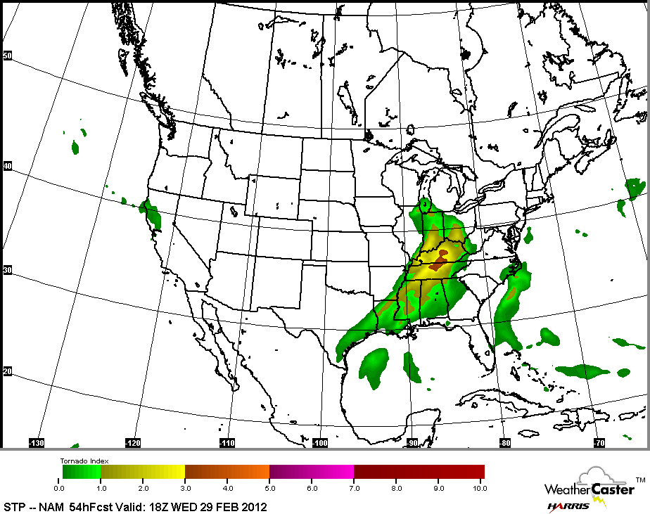
This next map shows me the potential for tornadoes - we are getting some indications from looking at the soundings that tornadoes can't be ruled out. If these were to occur it would be during the overnight period on Tuesday and then another window of opportunity on Wednesday. We will have to monitor this part of the forecast. The tornado threat does not appear high - but of course it only takes one or two tornadoes to cause problems.
.
This first map is for around 11 pm on Tuesday night into the 1 am time frame on Wednesday morning. The brighter the color the better the chance for tornadoes - you can see how the colors change as you move from the outer colors to the inner colors (inner colors are better risk for tornadoes)
.

.
This next map is the same kind of map but a bit later - towards the 1 am through 3 am time frame on Wednesday morning. You can see the colors increase over our local area. Again - this is a concern because it is so late at night. Good idea to keep the weather radios on. The risk appears fairly low - but not zero.
.

.
The next map is for around 7 am on Wednesday morning - you can see our region is still in a risk zone. But this will be the in-between time from the first round and second round. This is where the most uncertainty in the forecast arrives. Watch for updates.
.
 .
.
Then as we push into Wednesday morning - this map is for around 9 am
.

Keep in mind...
.
A lot of the shear with this system may be SPEED shear vs directional shear. That means the winds increase with height - rather sharply. For a more significant tornado threat you want to see DIRECTIONAL shear, as well. This leads me to believe that the main concern with this system may be damaging winds (if severe weather develops). The tornado threat may be more small spin-ups or mesoVORTICES - small spin ups near the squall line or embedded with a squall line or any isolated cells that develop. Again - the threat for any tornadoes appears LOW. But I am just pointing out if something were to develop that the above information would be the most likely scenario.
Now for you weather savvy readers - let's go through some of the severe weather parameter maps for this coming event on Tuesday night into Wednesday. These maps show you what I am looking at when I start thinking about putting severe thunderstorms into the forecast.
.
These maps are large - so I reduced their size. In order to view their real size just click on each map.
.
This first map shows you storm motion - how fast will the storms be moving on Tuesday night and Wednesday - this maps tells me that storms will be moving along at speeds of 30-50 mph. Perhaps a bit faster at times. Storms will be moving towards the east/northeast.
.

.
This next map gives me a general idea of how large hail would be - if hail were to occur at all. This maps is telling me that hail could range in the size from nickels to quarters - perhaps a little larger in a few cells. The timing on this map is Wednesday morning between 6 am and 11 am - this would be that second round potential. Again - this will need to be fine tuned, as far as what time the front crosses the region.
.

.
This next map shows me the potential for tornadoes - we are getting some indications from looking at the soundings that tornadoes can't be ruled out. If these were to occur it would be during the overnight period on Tuesday and then another window of opportunity on Wednesday. We will have to monitor this part of the forecast. The tornado threat does not appear high - but of course it only takes one or two tornadoes to cause problems.
.
This first map is for around 11 pm on Tuesday night into the 1 am time frame on Wednesday morning. The brighter the color the better the chance for tornadoes - you can see how the colors change as you move from the outer colors to the inner colors (inner colors are better risk for tornadoes)
.

.
This next map is the same kind of map but a bit later - towards the 1 am through 3 am time frame on Wednesday morning. You can see the colors increase over our local area. Again - this is a concern because it is so late at night. Good idea to keep the weather radios on. The risk appears fairly low - but not zero.
.

.
The next map is for around 7 am on Wednesday morning - you can see our region is still in a risk zone. But this will be the in-between time from the first round and second round. This is where the most uncertainty in the forecast arrives. Watch for updates.
.

Then as we push into Wednesday morning - this map is for around 9 am
.

.
This map is for around 10 am through 1 pm on Wednesday - you can see the threat diminishing and moving east. It appears from these maps that if there were going to be a small tornado threat that the greatest time frame might be between 11 pm Tuesday night and 8 am on Wednesday morning. We don't like overnight events for severe weather because they catch people off-guard. Monitor for updates.
.

.
The maps below are from the EHI index - basically this tells me how much spin there is in the atmosphere and whether or not we have to be concerned about tornadoes. You can see that this index is also showing the potential for a tornado or two - but again - this is conditional. These maps are from www.wright-weather.com - my favorite source for model data. Again - click image for full size view.
.
A lot of the shear with this system may be SPEED shear vs directional shear. That means the winds increase with height - rather sharply. For a more significant tornado threat you want to see DIRECTIONAL shear, as well. This leads me to believe that the main concern with this system may be damaging winds (if severe weather develops). The tornado threat may be more small spin-ups or mesoVORTICES - small spin ups near the squall line or embedded with a squall line or any isolated cells that develop. Again - the threat for any tornadoes appears LOW. But I am just pointing out if something were to develop that the above information would be the most likely scenario.
.
This first map is for around 11 pm through 2 am on Tuesday night and Wednesday morning
.

Then as we move into the 4 am through 8 am time frame on Wednesday morning - you can see a spike over our region. Again this is a concern because of it being so late at night.
.
 .
.
This map below is from the 8 am through 11 am time frame - still a concern - some spin in the atmosphere.
.

.
Then as we push through the day on Wednesday - the threat shifts east of our immediate local area - the maps below are from late morning into the evening hours on Wednesday. The threat pushes east as the cold front moves through - this is why the timing of the front is important.

This map is for Wednesday evening - below

.
This is a fairly robust storm - a blizzard in the north and severe weather in the south - widespread precipitation event. Here is the broad-brushed map for Tuesday into Wednesday morning - just look at the expanse of precipitation over the nation. Big storm.
.

.
We have a TON of new weather maps on the Weather Observatory web-site - these include temperatures, wind speed, dew points, heat index, barometric pressure, predicted rainfall, climate forecast, medium and long range maps, forecasts and more! Click here

This map is for around 10 am through 1 pm on Wednesday - you can see the threat diminishing and moving east. It appears from these maps that if there were going to be a small tornado threat that the greatest time frame might be between 11 pm Tuesday night and 8 am on Wednesday morning. We don't like overnight events for severe weather because they catch people off-guard. Monitor for updates.
.
.
The maps below are from the EHI index - basically this tells me how much spin there is in the atmosphere and whether or not we have to be concerned about tornadoes. You can see that this index is also showing the potential for a tornado or two - but again - this is conditional. These maps are from www.wright-weather.com - my favorite source for model data. Again - click image for full size view.
.
A lot of the shear with this system may be SPEED shear vs directional shear. That means the winds increase with height - rather sharply. For a more significant tornado threat you want to see DIRECTIONAL shear, as well. This leads me to believe that the main concern with this system may be damaging winds (if severe weather develops). The tornado threat may be more small spin-ups or mesoVORTICES - small spin ups near the squall line or embedded with a squall line or any isolated cells that develop. Again - the threat for any tornadoes appears LOW. But I am just pointing out if something were to develop that the above information would be the most likely scenario.
.
This first map is for around 11 pm through 2 am on Tuesday night and Wednesday morning
.

Then as we move into the 4 am through 8 am time frame on Wednesday morning - you can see a spike over our region. Again this is a concern because of it being so late at night.
.

This map below is from the 8 am through 11 am time frame - still a concern - some spin in the atmosphere.
.

.
Then as we push through the day on Wednesday - the threat shifts east of our immediate local area - the maps below are from late morning into the evening hours on Wednesday. The threat pushes east as the cold front moves through - this is why the timing of the front is important.

This map is for Wednesday evening - below

.
This is a fairly robust storm - a blizzard in the north and severe weather in the south - widespread precipitation event. Here is the broad-brushed map for Tuesday into Wednesday morning - just look at the expanse of precipitation over the nation. Big storm.
.
.
We have a TON of new weather maps on the Weather Observatory web-site - these include temperatures, wind speed, dew points, heat index, barometric pressure, predicted rainfall, climate forecast, medium and long range maps, forecasts and more! Click here
.
I have also added a few new interactive city radars - including the Memphis, Tennessee area and the rest of the State of Kentucky.
.
.
-----------------------------
-----------------------------
.
.
Let's check out the how much rain is forecast to fall over the next 24 hours. This map gives you a general broad brushed idea of what can be expected. Remember the scale is at the top of the map.
.
If you would like to view the most up to date 24, 48, 72, and 120 hour precipitation forecast maps then click here.
.
Here is the rainfall outlook - this will take us through the entire event - you get the general idea of what we are looking at. Of course thunderstorms can produce locally heavier amounts.
.

.
If you would like to view the most up to date 24, 48, 72, and 120 hour precipitation forecast maps then click here.
.
Here is the rainfall outlook - this will take us through the entire event - you get the general idea of what we are looking at. Of course thunderstorms can produce locally heavier amounts.
.


.
You can also now view the probability of X amount of rain (you pick the value on the web-site) in a six hour period of time. Those maps can be viewed here.
.
You can view drought maps on the Weather Observatory web-site by clicking here.
.

You can also now view the probability of X amount of rain (you pick the value on the web-site) in a six hour period of time. Those maps can be viewed here.
.
You can view drought maps on the Weather Observatory web-site by clicking here.
.
.
.
No significant snow in our forecast...
.
No significant snow in our forecast...
.
Enhanced snowfall interactive forecast maps . You can choose your total snowfall amounts above the map - time frame, as well- click here
.
Snowfall forecast maps - these are interactive maps. You can choose your total snowfall amounts above the map - time frame, as well - click here
Enhanced snowfall interactive forecast maps . You can choose your total snowfall amounts above the map - time frame, as well- click here
.
Snowfall forecast maps - these are interactive maps. You can choose your total snowfall amounts above the map - time frame, as well - click here
.
If you are looking for wintry precipitation - click here.
.
.

.
You can view the upcoming days high temperature and low temperature forecasts by clicking here - choose the day - click on your state to zoom in
You can view the upcoming days high temperature and low temperature forecasts by clicking here - choose the day - click on your state to zoom in
.
 .
. We have a number of new radars available on our Weather Observatory web-site!
---
We now offer St Louis, Mt Vernon, Evansville, Poplar Bluff, Cape Girardeau, Marion, Paducah, Hopkinsville, and Dyersburg Interactive City Radars. We also have the two regional radars and now offer you three GR Earth radars.
http://www.weatherobservatory.com/weather-radar.htm---
---
We also have a new interactive radar - you can view that radar by clicking here.
.
Want to learn more about how to use our radars? I made a how to video with more information
Click here - http://www.youtube.com/watch?v=bfLa0hI3adU
.
.
.
.
---

.
Date Range: February 25th-March 10th
Event: Active weather pattern with several chances for precipitation.
Severe Risk: Likely going to be some severe weather over the coming weeks
Frozen Precipitation Risk: Uncertain
Details:
Confidence in my forecast: Medium
.
.
Date Range: February 25th-March 10th
Event: Active weather pattern with several chances for precipitation.
Severe Risk: Likely going to be some severe weather over the coming weeks
Frozen Precipitation Risk: Uncertain
Details:
Confidence in my forecast: Medium
.
.
.
Remember that as a general policy, in the long range outlook, I will NOT mention severe thunderstorms more than 72 hours in advance. I will mention thunderstorm risks and I will give as many details as possible. The word severe will be reserved for the short range forecast.
.
-----------------------------
.

What are the chances for a winter weather event (see definition below - over southeast Missouri, southern Illinois, southwest Indiana, western Kentucky, northeast Arkansas, or northwest Tennessee?
.
Winter weather event would be the potential for snow - icy travel conditions with enough sleet or freezing rain to cause advisories and/or winter storm watches/warnings to be issued by the National Weather Service.
Winter STORM outlook...
.
.
Winter weather event would be the potential for snow - icy travel conditions with enough sleet or freezing rain to cause advisories and/or winter storm watches/warnings to be issued by the National Weather Service.
.
Tuesday - 0%
Wednesday - 0% Thursday - 0%
Friday - 0%
Saturday - 0%
Friday - 0%
Saturday - 0%
Sunday - 0%
.
.
1. Another storm system will take aim at our region on Friday into Saturday. Right now the parameters appear favorable for some of the thunderstorms to be heavy. We will once again have to monitor this time frame for the possibility of severe thunderstorms. I like to keep the severe forecasts confined to the short range discussion. Monitor for updates as we push through the work week.
.
.
Now is a GREAT time to buy a NOAA All Hazards Weather Radio. Better to have one before storms strike than to be without one during an event. I recommend the Midland Model 300 NOAA All Hazards Weather Radio - that is what I use here at my house!
.
Meteorologist Beau DodsonMcCracken County Office of Emergency Management
.

.
Beau Dodson Weather - Facebook
.

To view all watches and warnings in Illinois - Click Here
To view all watches and warnings in Kentucky - Click Here
To view all watches and warnings in Missouri - Click Here
To view all watches and warnings in Tennessee - Click Here
.
All other states- Click Here
.
For the latest watches and warnings please visit your local National Weather Service Office web-site.
http://www.weather.gov/organization.php
.
Remember most of these maps can be viewed straight off of the Weather Observatory Web-Site
.

.
No comments:
Post a Comment