.
For more frequent updates check out the weather Facebook page - click here and hit like at the top of the page.
.
This page is best viewed with Mozilla Firefox. There could be issues with spacing on Internet Explorer
.

.
Here are my current personal forecast thoughts for far southern Illinois and western Kentucky...
.
Sunday night: Mostly clear sky conditions
Above normal temperatures
Lows: in the middle 30s | Normal lows for this time of the year are around 30 degrees.Above normal temperatures
Wind: South/southwest winds at 5-10 mph.
Precipitation probability - 0% | Rainfall totals: 0"
Confidence in this forecast is very high
.
Monday: Mostly sunny. Just a few clouds from time to time
Above normal temperatures
Highs: around 55-60 degrees. | Normal highs for this time of the year are around 50 degrees.Above normal temperatures
Wind: Northwest winds at 5-10 mph
Precipitation probability - 0% | Rainfall totals: 0"
Confidence in this forecast is very high
.
Monday night: Partly cloudy skies.
Above normal temperatures
Above normal temperatures
Lows: in the middle to upper 30s | Normal lows for this time of the year are around 30 degrees.
Wind: Northeast at 5-10 mph
Precipitation probability - 0% | Rainfall totals: 0"
Confidence in this forecast is high
Wind: Northeast at 5-10 mph
Precipitation probability - 0% | Rainfall totals: 0"
Confidence in this forecast is high
.
Tuesday: Increasing clouds - a chance for a few showers - perhaps a thunderstorm. Chances for precipitation increase more on Tuesday night.
Above normal temperatures
Highs: around 62-66 degrees | Normal highs for this time of the year are around 50 degrees.Wind: Southerly winds at 5-15 mph with gusts to 28 mph
Precipitation probability - 40% | Rainfall totals: 0.10"-0.30"
Confidence in this forecast is medium
.
Don't forget to sign up for the severe weather "heads up" email list - I usually email everyone before a big event - severe weather or winter storms - ice storms. Click here to join
.

.
.
Don't forget to sign up for the severe weather "heads up" email list - I usually email everyone before a big event - severe weather or winter storms - ice storms. Click here to join
.
.

No major concerns in the short range forecast - thunderstorms arrive on Tuesday into Wednesday morning - see the discussion below.

No - nothing of concern until we get into Tuesday night

No significant wild cards in the short range forecast. I will be watching Tuesday night into Wednesday morning for thunderstorms. Some uncertainty as to whether we will have any severe weather to worry about. Will monitor and update on Monday afternoon (or on the Facebook page)
.
.

No significant snow in this short range forecast...
.

.
.
.
No major changes in this update!
.

.
Forecast for your local town/city - Click Here
.
..
Join me on Facebook for more frequent updates on the weather in our local areaClick Here.
.
---

The forecast for severe or extreme weather for the next 48 hours
.
The McCracken County Office of Emergency Management reminds you that owning a NOAA All Hazards Weather Radio is the best way to receive notifications of severe weather watches and warnings.
.
Remember that the National Weather Service defines a severe thunderstorm as one that produces 58 mph winds or higher, hail 1" in size or larger, and/or a tornado. More information with some slides concerning reporting severe weather - click here
.
For the most up to date severe weather outlooks - click here.
or
Visit the Storm Prediction Center's web-site - click here
.
Sunday night: Severe weather is not anticipated. No snow or ice.
Sunday night: Will there be a chance for non-severe thunderstorms? No
.
.
Sunday night: Severe weather is not anticipated. No snow or ice.
Sunday night: Will there be a chance for non-severe thunderstorms? No
.
Monday: Severe weather is not anticipated. No snow or ice.
Monday: Will there be a chance for non-severe thunderstorms? No
.Monday: Will there be a chance for non-severe thunderstorms? No
Monday night : Severe weather is not anticipated. No snow or ice.
Monday night: Will there be a chance for non-severe thunderstorms? No
.
Tuesday: Severe weather is not anticipated during the daytime hours - we will have to monitor Tuesday night/Wednesday morning for the potential of a few severe thunderstorms.
Tuesday: Will there be a risk for non-severe thunderstorms? A few thunderstorms possible
.
.
 .
.
Will the Storm Prediction Center issue a tornado or severe thunderstorm watch for southeast Missouri, southern Illinois, or western Kentucky?
.
Tonight - No
Monday - No
Tuesday - No
Tuesday night - possible - monitor for updates
Tuesday: Will there be a risk for non-severe thunderstorms? A few thunderstorms possible
.
.
Will the Storm Prediction Center issue a tornado or severe thunderstorm watch for southeast Missouri, southern Illinois, or western Kentucky?
.
Tonight - No
Monday - No
Tuesday - No
Tuesday night - possible - monitor for updates
Wednesday - possible on Wednesday - monitor for updates
Thursday - No
Friday - No

.
To view all watches and warnings in IL - Click Here
To view all watches and warnings in KY - Click Here
To view all watches and warnings in MO - Click Here
To view all watches and warnings in TN - Click Here
All other states- Click Here
To view all watches and warnings in IL - Click Here
To view all watches and warnings in KY - Click Here
To view all watches and warnings in MO - Click Here
To view all watches and warnings in TN - Click Here
All other states- Click Here
.
The links above are interactive and you can move around the United States by simply clicking on the national map - or from the pull down menu where it says regions and US States.
.
To view the interactive map - click here.
.
To view the interactive map - click here.
.
.

This forecast analysis covers far southern Illinois, southeast Missouri, southwest Indiana, western Kentucky, and northwest Tennessee - for your local town/area - click here
.
HEADLINE: Well - here we go - into the home stretch - March is jussssst within reach! I can hear all of the spring fans cheering - applauding the end of winter! I can hear all of the winter fans - booing and hissing. Of course this doesn't mean we can't still experience some wintry weather - but it does mean we will see temperatures increasing and the cold spells growing shorter (what cold there has been - I should say).
.
Winter 2010-2011 will be remembered as the "year without a winter" - at least in most of the continental United States. Perhaps one of the warmest winters on record? We will have to wait for those numbers to be crunched (meteorologist consider winter to be December 1st through the last day of February).
.
Let's just take a quick look at a few maps from the last couple of months - just how much above normal have temperatures been? WELL above normal would be the resounding answer.
.
This map is from November 1st through the end of January - all that red and orange - that is above normal temperatures - WELL above normal temperatures.
.
 .
.
This map below - shows you the temperature departures from January 27th through February 25th - again MUCH ABOVE normal temperatures. Am I telling you anything you did not already know? It has been one of the mildest winters that I can remember - across the United States. Alaska has been cold - but we are talking about the continental United States.
.

.
Okay - well we knew it was a mild winter. Appears we are going to end on a mild note, as well.
.
Let's take a look at the record high temperatures and record high minimum temperatures for the past week (record high minimum temperature means the warmest low temperature on record)
.

.
Our next storm system is taking shape to our west. This one is giving off some signals that it may produce a few severe thunderstorms somewhere in the central United States - but where? That is the question that remains. Let's take a look at a few maps.
.
First off - here is the official Storm Prediction Center severe weather outlook - remember they have three levels of concern. The first level is SLIGHT risk - the second level is MODERATE risk - the final level is the HIGH risk. They have outlined a SLIGHT RISK for Tuesday into Tuesday night - just a bunnies hair to our west. This has moved around over the last few days - it will likely move around a bit more over the next 48 hours. That means you should watch for updates.
.
Here is the SPC outlook - the orange area is the slight risk zone. Slight risk means that some severe thunderstorms are likely to occur but they are not expected to be WIDESPREAD in nature. A moderate or high risk would mean a more widespread event.
.
 What is expected to happen in our local region?
.
A deep area of low pressure will move into the Midwest on Tuesday - this deep low will drag a warm front into our region on Monday night and Tuesday - the warm front will spark a few showers and thunderstorms along and ahead of it (mainly on Tuesday late morning into Tuesday afternoon) - then the cold front will arrive on Tuesday night and Wednesday morning with another round of showers and locally heavy thunderstorms.
.
Rainfall totals are probably going to be in the 0.20-0.50" range - locally heavier in thunderstorms.
.
Here is what that deep area of low pressure looks like on the weather map - this map is from the GFS model and is from www.wright-weather.com
.
See the deep low up near Iowa with all the lines around it? Those are equal lines of pressure - the deeper the low - the more lines you will see wrapped around it. This is a decent system.
.
The pink and blue - that is precipitation. This map image is the forecast for around 11 pm Tuesday night into 2 am Wednesday morning. You get the general idea of the placement of the storm system.
.

What is lacking from this system is deep moisture. Dew points should rise into the 50s on Tuesday night - 50s are sufficient for thunderstorms. To have severe weather we like to see dew points well into the 50s or even 60s (although severe weather can occur with lower dew points under the right conditions).
.
What this storm system has going for it - strong wind fields. I will show you a few maps below.
.
Here are the dew points for late Tuesday night - you can see the yellow area - those are 50s and approaching 60. They nudge close to our region - but not fully into our region. If those dew points were further north then I would be more concerned about severe weather. We need to monitor this in the coming days.
.
Note how the system PULLS those dew points up from the Gulf of Mexico - AHEAD of the cold front. The area of low pressure spins counter-clockwise - thus pulling Gulf of Mexico moisture northward. See how it pulls in drier air behind it? That is air from the Northern Plains and Canada (not the best source for moisture).
.

.
.
Now let's take a look at the wind fields - which are fairly impressive. Again from my favorite source of model data - www.wright-weather.com - this map shows you the wind fields several thousand feet above the surface (the 850 mb level). Those deep reds are winds in excess of 55-60 knots. Sufficient for thunderstorms and sufficient for a few severe thunderstorms.
.
The stronger the wind fields that a system has - the faster the jet stream - the faster those winds are at all levels - the better chance for severe weather (assuming you have moisture and instability to work with).
.

.
Now let's go even higher up into the atmosphere and look at the 500 mb level - click image for FULL VIEW SIZE
.
You can see a strong jet max over Missouri into Iowa - as the low tightens up the winds are increasing in the trough. You see some diffluence there, as well - meaning winds pulling away from the same direction - image a fan that you would use in a church service and how it spreads apart. When you see diffluence you know the air is rising (at this level). This helps keep the showers and thunderstorms going. You can also see the 500 mb low up over the Dakotas into Minnesota - this is a sign of a well organized storm.
.

.
Now let's look at CAPE - remember that CAPE is basically energy that is available in the atmosphere. You will see me post CAPE maps from time to time in the coming months. The higher the numbers the higher the level of energy available for thunderstorms. This time of the year you can have heavy weather with CAPES below 1000. You can see by these maps that CAPE struggles in our region. This is something that will have to be monitored. If these numbers were higher then I would be more concerned about severe weather. This needs to be closely monitored.
.
Click image for full view size. Again from www.wright-weather.com
.
 And finally let's take a look at the EHI values - this gives us some insight into how much spin there is in the atmosphere. You can see there is some concern that any storms that form could spin.
.

.
What does all of this mean?
.
A chance for showers and thunderstorms on Tuesday into Wednesday morning. The main cold front arrives on Tuesday night into the early AM hours of Wednesday. Right now there are several pro's and con's for severe weather - let's take a look at them
.
Pro's for severe weather
.
1. Plenty of wind energy available in the atmosphere. Upper level winds will be strong.
2. Strong cold front
3. Plenty of lift along the cold front
.
Con's against severe weather
.
1. Timing of the front will be late at night
2. Instability appears move elevated vs surface based (for severe weather you need to have more surface based instability). The elevated instability appears to occur in a narrow window of time on Tuesday night and early AM Wednesday hours.
3. Instability levels will be minimal
4. Dew points will be marginal
.
Conclusion...
.
One round of showers and thunderstorms will be possible along the warm front on Tuesday into Tuesday afternoon - then a lull in precipitation.
.
Thunderstorms will likely again impact our region on Tuesday into Wednesday morning. The severe weather threat appears greatest just to our west over Missouri and Arkansas. However, this is going to depend on just how much moisture returns - I would not be a bit surprised to see the SPC extend the risk zone a bit further east into our region on future updates.
.
A line of thunderstorms will likely move through the region late on Tuesday night into Wednesday AM hours. This line could produce a few reports of severe weather (in our local region) - but the risk may be mitigated a bit because of the lack of deep moisture - monitor for updates.
.
Monitor for updates in the event some of the above parameters change. The NWS Office in Paducah, KY has said much of what I said above.
.
Temperatures the next few days will be above normal - surprised? I didn't think so. Just how much above normal? Well let's pull up the maps and take a look.
.
These maps show you HOW MUCH above normal or below normal temperatures will be. Normal temperatures for this time of the year are in the lower 30s for low temperatures and near 50 degrees for high temperatures. Slowly inching upward!
.
Here are the maps for Monday into Thursday
.


.
We have a TON of new weather maps on the Weather Observatory web-site - these include temperatures, wind speed, dew points, heat index, barometric pressure, predicted rainfall, climate forecast, medium and long range maps, forecasts and more! Click here
.
HEADLINE: Well - here we go - into the home stretch - March is jussssst within reach! I can hear all of the spring fans cheering - applauding the end of winter! I can hear all of the winter fans - booing and hissing. Of course this doesn't mean we can't still experience some wintry weather - but it does mean we will see temperatures increasing and the cold spells growing shorter (what cold there has been - I should say).
.
Winter 2010-2011 will be remembered as the "year without a winter" - at least in most of the continental United States. Perhaps one of the warmest winters on record? We will have to wait for those numbers to be crunched (meteorologist consider winter to be December 1st through the last day of February).
.
Let's just take a quick look at a few maps from the last couple of months - just how much above normal have temperatures been? WELL above normal would be the resounding answer.
.
This map is from November 1st through the end of January - all that red and orange - that is above normal temperatures - WELL above normal temperatures.
.
This map below - shows you the temperature departures from January 27th through February 25th - again MUCH ABOVE normal temperatures. Am I telling you anything you did not already know? It has been one of the mildest winters that I can remember - across the United States. Alaska has been cold - but we are talking about the continental United States.
.
.
Okay - well we knew it was a mild winter. Appears we are going to end on a mild note, as well.
.
Let's take a look at the record high temperatures and record high minimum temperatures for the past week (record high minimum temperature means the warmest low temperature on record)
.
.
Our next storm system is taking shape to our west. This one is giving off some signals that it may produce a few severe thunderstorms somewhere in the central United States - but where? That is the question that remains. Let's take a look at a few maps.
.
First off - here is the official Storm Prediction Center severe weather outlook - remember they have three levels of concern. The first level is SLIGHT risk - the second level is MODERATE risk - the final level is the HIGH risk. They have outlined a SLIGHT RISK for Tuesday into Tuesday night - just a bunnies hair to our west. This has moved around over the last few days - it will likely move around a bit more over the next 48 hours. That means you should watch for updates.
.
Here is the SPC outlook - the orange area is the slight risk zone. Slight risk means that some severe thunderstorms are likely to occur but they are not expected to be WIDESPREAD in nature. A moderate or high risk would mean a more widespread event.
.
.
A deep area of low pressure will move into the Midwest on Tuesday - this deep low will drag a warm front into our region on Monday night and Tuesday - the warm front will spark a few showers and thunderstorms along and ahead of it (mainly on Tuesday late morning into Tuesday afternoon) - then the cold front will arrive on Tuesday night and Wednesday morning with another round of showers and locally heavy thunderstorms.
.
Rainfall totals are probably going to be in the 0.20-0.50" range - locally heavier in thunderstorms.
.
Here is what that deep area of low pressure looks like on the weather map - this map is from the GFS model and is from www.wright-weather.com
.
See the deep low up near Iowa with all the lines around it? Those are equal lines of pressure - the deeper the low - the more lines you will see wrapped around it. This is a decent system.
.
The pink and blue - that is precipitation. This map image is the forecast for around 11 pm Tuesday night into 2 am Wednesday morning. You get the general idea of the placement of the storm system.
.

What is lacking from this system is deep moisture. Dew points should rise into the 50s on Tuesday night - 50s are sufficient for thunderstorms. To have severe weather we like to see dew points well into the 50s or even 60s (although severe weather can occur with lower dew points under the right conditions).
.
What this storm system has going for it - strong wind fields. I will show you a few maps below.
.
Here are the dew points for late Tuesday night - you can see the yellow area - those are 50s and approaching 60. They nudge close to our region - but not fully into our region. If those dew points were further north then I would be more concerned about severe weather. We need to monitor this in the coming days.
.
Note how the system PULLS those dew points up from the Gulf of Mexico - AHEAD of the cold front. The area of low pressure spins counter-clockwise - thus pulling Gulf of Mexico moisture northward. See how it pulls in drier air behind it? That is air from the Northern Plains and Canada (not the best source for moisture).
.

.
.
Now let's take a look at the wind fields - which are fairly impressive. Again from my favorite source of model data - www.wright-weather.com - this map shows you the wind fields several thousand feet above the surface (the 850 mb level). Those deep reds are winds in excess of 55-60 knots. Sufficient for thunderstorms and sufficient for a few severe thunderstorms.
.
The stronger the wind fields that a system has - the faster the jet stream - the faster those winds are at all levels - the better chance for severe weather (assuming you have moisture and instability to work with).
.

.
Now let's go even higher up into the atmosphere and look at the 500 mb level - click image for FULL VIEW SIZE
.
You can see a strong jet max over Missouri into Iowa - as the low tightens up the winds are increasing in the trough. You see some diffluence there, as well - meaning winds pulling away from the same direction - image a fan that you would use in a church service and how it spreads apart. When you see diffluence you know the air is rising (at this level). This helps keep the showers and thunderstorms going. You can also see the 500 mb low up over the Dakotas into Minnesota - this is a sign of a well organized storm.
.

.
Now let's look at CAPE - remember that CAPE is basically energy that is available in the atmosphere. You will see me post CAPE maps from time to time in the coming months. The higher the numbers the higher the level of energy available for thunderstorms. This time of the year you can have heavy weather with CAPES below 1000. You can see by these maps that CAPE struggles in our region. This is something that will have to be monitored. If these numbers were higher then I would be more concerned about severe weather. This needs to be closely monitored.
.
Click image for full view size. Again from www.wright-weather.com
.

.

.
What does all of this mean?
.
A chance for showers and thunderstorms on Tuesday into Wednesday morning. The main cold front arrives on Tuesday night into the early AM hours of Wednesday. Right now there are several pro's and con's for severe weather - let's take a look at them
.
Pro's for severe weather
.
1. Plenty of wind energy available in the atmosphere. Upper level winds will be strong.
2. Strong cold front
3. Plenty of lift along the cold front
.
Con's against severe weather
.
1. Timing of the front will be late at night
2. Instability appears move elevated vs surface based (for severe weather you need to have more surface based instability). The elevated instability appears to occur in a narrow window of time on Tuesday night and early AM Wednesday hours.
3. Instability levels will be minimal
4. Dew points will be marginal
.
Conclusion...
.
One round of showers and thunderstorms will be possible along the warm front on Tuesday into Tuesday afternoon - then a lull in precipitation.
.
Thunderstorms will likely again impact our region on Tuesday into Wednesday morning. The severe weather threat appears greatest just to our west over Missouri and Arkansas. However, this is going to depend on just how much moisture returns - I would not be a bit surprised to see the SPC extend the risk zone a bit further east into our region on future updates.
.
A line of thunderstorms will likely move through the region late on Tuesday night into Wednesday AM hours. This line could produce a few reports of severe weather (in our local region) - but the risk may be mitigated a bit because of the lack of deep moisture - monitor for updates.
.
Monitor for updates in the event some of the above parameters change. The NWS Office in Paducah, KY has said much of what I said above.
.
Temperatures the next few days will be above normal - surprised? I didn't think so. Just how much above normal? Well let's pull up the maps and take a look.
.
These maps show you HOW MUCH above normal or below normal temperatures will be. Normal temperatures for this time of the year are in the lower 30s for low temperatures and near 50 degrees for high temperatures. Slowly inching upward!
.
Here are the maps for Monday into Thursday
.
.
We have a TON of new weather maps on the Weather Observatory web-site - these include temperatures, wind speed, dew points, heat index, barometric pressure, predicted rainfall, climate forecast, medium and long range maps, forecasts and more! Click here
.
I have also added a few new interactive city radars - including the Memphis, Tennessee area and the rest of the State of Kentucky.
.
.
-----------------------------
.

.
Let's check out the how much rain is forecast to fall over the next 48 hours. This map gives you a general broad brushed idea of what can be expected. Remember the scale is at the top of the map.
.
If you would like to view the most up to date 24, 48, 72, and 120 hour precipitation forecast maps then click here.
.
Keep in mind that this is only through Tuesday MORNING.
.

.
.
If you would like to view the most up to date 24, 48, 72, and 120 hour precipitation forecast maps then click here.
.
Keep in mind that this is only through Tuesday MORNING.
.
.
.

.
You can also now view the probability of X amount of rain (you pick the value on the web-site) in a six hour period of time. Those maps can be viewed here.
.
You can view drought maps on the Weather Observatory web-site by clicking here.
.

You can also now view the probability of X amount of rain (you pick the value on the web-site) in a six hour period of time. Those maps can be viewed here.
.
You can view drought maps on the Weather Observatory web-site by clicking here.
.
.
.
No significant snow in our forecast...
.
No significant snow in our forecast...
.
Enhanced snowfall interactive forecast maps . You can choose your total snowfall amounts above the map - time frame, as well- click here
.
Snowfall forecast maps - these are interactive maps. You can choose your total snowfall amounts above the map - time frame, as well - click here
Enhanced snowfall interactive forecast maps . You can choose your total snowfall amounts above the map - time frame, as well- click here
.
Snowfall forecast maps - these are interactive maps. You can choose your total snowfall amounts above the map - time frame, as well - click here
.
If you are looking for wintry precipitation - click here.
.
.

.
You can view the upcoming days high temperature and low temperature forecasts by clicking here - choose the day - click on your state to zoom in
You can view the upcoming days high temperature and low temperature forecasts by clicking here - choose the day - click on your state to zoom in
.
 .
. We have a number of new radars available on our Weather Observatory web-site!
---
We now offer St Louis, Mt Vernon, Evansville, Poplar Bluff, Cape Girardeau, Marion, Paducah, Hopkinsville, and Dyersburg Interactive City Radars. We also have the two regional radars and now offer you three GR Earth radars.
http://www.weatherobservatory.com/weather-radar.htm---
---
We also have a new interactive radar - you can view that radar by clicking here.
.
Want to learn more about how to use our radars? I made a how to video with more information
Click here - http://www.youtube.com/watch?v=bfLa0hI3adU
.
.
.
.
---

.
Date Range: February 25th-March 10th
Event: Active weather pattern with several chances for precipitation.
Severe Risk: Likely going to be some severe weather over the coming weeks
Frozen Precipitation Risk: Uncertain
Details:
Confidence in my forecast: Medium
.
.
Date Range: February 25th-March 10th
Event: Active weather pattern with several chances for precipitation.
Severe Risk: Likely going to be some severe weather over the coming weeks
Frozen Precipitation Risk: Uncertain
Details:
Confidence in my forecast: Medium
.
.
.
Remember that as a general policy, in the long range outlook, I will NOT mention severe thunderstorms more than 72 hours in advance. I will mention thunderstorm risks and I will give as many details as possible. The word severe will be reserved for the short range forecast.
.
-----------------------------
.

What are the chances for a winter weather event (see definition below - over southeast Missouri, southern Illinois, southwest Indiana, western Kentucky, northeast Arkansas, or northwest Tennessee?
.
Winter weather event would be the potential for snow - icy travel conditions with enough sleet or freezing rain to cause advisories and/or winter storm watches/warnings to be issued by the National Weather Service.
Winter STORM outlook...
.
What are the chances for a winter weather event (see definition below - over southeast Missouri, southern Illinois, southwest Indiana, western Kentucky, northeast Arkansas, or northwest Tennessee?
.
Winter weather event would be the potential for snow - icy travel conditions with enough sleet or freezing rain to cause advisories and/or winter storm watches/warnings to be issued by the National Weather Service.
.
Sunday - 0%
Monday - 0% Tuesday - 0%
Wednesday - 0%
Thursday - 0%
Wednesday - 0%
Thursday - 0%
Friday - 0%
.
.
1. I spent a lot of time on the short range forecast :) - the long range forecast will center around another chance for rain and storms next Friday night into Saturday. Way too soon to talk about severe weather. I like to keep the severe weather talk to the short range part of the forecast.
.
Rainfall totals with the Friday night into Saturday storm will likely be in the 0.20-0.50" range. Still some time to iron out those details.
.
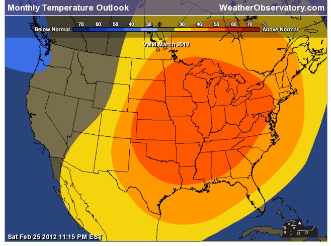
Temperatures for the next 6-12 days should average above normal. Here are the latest six to ten and eight to fourteen day outlooks.
.
Time stamps are at the top of the maps.
.

.
Rainfall totals with the Friday night into Saturday storm will likely be in the 0.20-0.50" range. Still some time to iron out those details.
.
Temperatures for the next 6-12 days should average above normal. Here are the latest six to ten and eight to fourteen day outlooks.
.
Time stamps are at the top of the maps.
.
Now is a GREAT time to buy a NOAA All Hazards Weather Radio. Better to have one before storms strike than to be without one during an event. I recommend the Midland Model 300 NOAA All Hazards Weather Radio - that is what I use here at my house!
.
Meteorologist Beau DodsonMcCracken County Office of Emergency Management
.

.
Beau Dodson Weather - Facebook
.

To view all watches and warnings in Illinois - Click Here
To view all watches and warnings in Kentucky - Click Here
To view all watches and warnings in Missouri - Click Here
To view all watches and warnings in Tennessee - Click Here
.
All other states- Click Here
.
For the latest watches and warnings please visit your local National Weather Service Office web-site.
http://www.weather.gov/organization.php
.
Remember most of these maps can be viewed straight off of the Weather Observatory Web-Site
.

.
No comments:
Post a Comment