Tuesday evening into Wednesday afternoon update
.
For more frequent updates check out the weather Facebook page - click here and hit like at the top of the page.
.
This page is best viewed with Mozilla Firefox. There could be issues with spacing on Internet Explorer
.

.
Here are my current personal forecast thoughts for far southern Illinois and western Kentucky...
.
Tuesday night: Mostly clear skies
Above normal temperatures
Lows: in the lower 40s | Normal lows for this time of the year are around 25 degrees.Above normal temperatures
Wind: Southwest winds at 5-10 mph.
Precipitation probability - 0% | Rainfall totals: 0"
Confidence in this forecast is very high
.
Wednesday: A mix of sun and clouds. A chance for a few thunderstorms. Mild for February.- windy at times
Above normal temperatures
Highs: around 65 degrees. | Normal highs for this time of the year are around 45 degrees.Above normal temperatures
Wind: Southwest winds at 10-20 mph with gusts above 25 mph
Precipitation probability - 30% | Rainfall totals: 0.25"
Confidence in this forecast is very high
.
Wednesday night: Partly cloudy skies. Evening thunderstorm possible.
Above normal temperatures
Above normal temperatures
Lows: in the upper 40s | Normal lows for this time of the year are around 25 degrees.
Wind: Southwest winds at 10-15 mph
Precipitation probability - 30% | Rainfall totals: 0.25"
Confidence in this forecast is high
Wind: Southwest winds at 10-15 mph
Precipitation probability - 30% | Rainfall totals: 0.25"
Confidence in this forecast is high
.
Thursday: A chance for a shower or thunderstorm - especially over Kentucky and Tennessee. Windy at times.
Above normal temperatures
Highs: around 65-70 degrees | Normal highs for this time of the year are around 45 degrees.Wind: West/Southwesterly winds at 10-20 mph - gusts above 25 mph possible
Precipitation probability - 40% | Rainfall totals: 0.20"-0.40" - heavier in thunderstorms (best chance for storms will be over KY/TN)
Confidence in this forecast is high
.
Don't forget to sign up for the severe weather "heads up" email list - I usually email everyone before a big event - severe weather or winter storms - ice storms. Click here to join
.

.
.
Don't forget to sign up for the severe weather "heads up" email list - I usually email everyone before a big event - severe weather or winter storms - ice storms. Click here to join
.
.

No major concerns - monitor for updates on Thursdays thunderstorms. Winds will be gusty the next few days.

Boaters use care on area rivers and lakes. Also - watch for updates on Thursdays severe weather potential - especially over parts of Kentucky and Tennessee.

The wild card in this forecast will be the placement of thunderstorms on Thursday as a system moves through our region. A few severe thunderstorms will be possible - right now it appears the greatest risk will be along the KY/TN border and then south and southeast of that area. Monitor for updates.
.

No significant snow in this short range forecast...
.

.
.
.
Added thunderstorms
.

.
Forecast for your local town/city - Click Here
.
..
Join me on Facebook for more frequent updates on the weather in our local areaClick Here.
.
---

The forecast for severe or extreme weather for the next 48 hours
.
The McCracken County Office of Emergency Management reminds you that owning a NOAA All Hazards Weather Radio is the best way to receive notifications of severe weather watches and warnings.
.
Remember that the National Weather Service defines a severe thunderstorm as one that produces 58 mph winds or higher, hail 1" in size or larger, and/or a tornado. More information with some slides concerning reporting severe weather - click here
.
For the most up to date severe weather outlooks - click here.
or
Visit the Storm Prediction Center's web-site - click here
.
Tuesday night: Severe weather is not anticipated. No snow or ice.
Tuesday night: Will there be a chance for non-severe thunderstorms? No
.
.
Tuesday night: Severe weather is not anticipated. No snow or ice.
Tuesday night: Will there be a chance for non-severe thunderstorms? No
.
Wednesday: Severe weather is not anticipated. No snow or ice.
Wednesday: Will there be a chance for non-severe thunderstorms? No
.Wednesday: Will there be a chance for non-severe thunderstorms? No
Wednesday night : Severe weather is not anticipated. No snow or ice.
Wednesday night: Will there be a chance for non-severe thunderstorms? No
.
Thursday: Yes - possible severe storms - right now the Storm Prediction Center and the NWS is leaning towards an area more south and east of our local counties - however, this could change. Monitor for updates..
Thursday: Will there be a risk for non-severe thunderstorms? Yes
.
.
 .
.
Will the Storm Prediction Center issue a tornado or severe thunderstorm watch for southeast Missouri, southern Illinois, or western Kentucky?
.
Tonight - No
Wednesday - No
Thursday - Possible - monitor for updates - risk appears mainly over our eastern counties
Thursday: Will there be a risk for non-severe thunderstorms? Yes
.
.
Will the Storm Prediction Center issue a tornado or severe thunderstorm watch for southeast Missouri, southern Illinois, or western Kentucky?
.
Tonight - No
Wednesday - No
Thursday - Possible - monitor for updates - risk appears mainly over our eastern counties
Friday - No
Saturday - No
Sunday - Will monitor Sunday night - low chance
Monday - Uncertain - monitor for updates
Tuesday - Uncertain - monitor for updates
Tuesday - Uncertain - monitor for updates

.
To view all watches and warnings in IL - Click Here
To view all watches and warnings in KY - Click Here
To view all watches and warnings in MO - Click Here
To view all watches and warnings in TN - Click Here
All other states- Click Here
To view all watches and warnings in IL - Click Here
To view all watches and warnings in KY - Click Here
To view all watches and warnings in MO - Click Here
To view all watches and warnings in TN - Click Here
All other states- Click Here
.
The links above are interactive and you can move around the United States by simply clicking on the national map - or from the pull down menu where it says regions and US States.
.
To view the interactive map - click here.
.
To view the interactive map - click here.
.
.

This forecast analysis covers far southern Illinois, southeast Missouri, southwest Indiana, western Kentucky, and northwest Tennessee - for your local town/area - click here
.
HEADLINE: WELCOME SPRING! Isn't that how it feels outside? A bit windy - but temps are above normal across our region again today. If you don't have spring fever just yet - wait until Wednesday and Thursday when temperatures will be well above 60 degrees. It will be windy over the next few days - area boaters should use care.
.
The only frog in the pond that we should monitor will be a storm system for Thursday afternoon and Thursday night. An area of low pressure is forecast to move through the Ohio Valley with a cold front. Along and ahead of this front the air will be a bit unstable - this means a few thunderstorms will be possible. Right now the SPC has outlined a risk zone just to our south and east for Thursday into Thursday night. This risk zone could experience large hail, damaging winds, and even some tornadoes.
.
There are differences of opinions on exactly where the area of low pressure will move - with the Thursday system. The EC Model shows a deepening low moving out of the Tennessee Valley into Kentucky on Thursday afternoon/evening. This system pulls moisture northward into Kentucky. The best instability levels may be just to our south - in Tennessee, Mississippi, Alabama, and Georgia.
.
Monitor updates on Thursday's system - the threat area may shift around a bit over the coming 48 hours.
.
Here is where the Storm Prediction Center (SPC) has outlined the risk zone - again, this may change over the next day or two - so check back
.

Here is the broad-brushed precipitation map for Thursday - you can see some showers and thunderstorms in our region.
.

Did you feel the earthquake this morning? It was a magnitude 4.0 and centered on the New Madrid Fault Zone. Many people in our region reported feeling a shake - the quake hit at 4 am this morning.
.
 Seismograph from Hopper, Tennessee
.

.
Monitor updated forecasts - they thought about including western Kentucky in the risk zone but opted not to. If this changes in future outlooks then I will post the update.
.
See the extended for the weekend into next week
.
We have a TON of new weather maps on the Weather Observatory web-site - these include temperatures, wind speed, dew points, heat index, barometric pressure, predicted rainfall, climate forecast, medium and long range maps, forecasts and more! Click here
.
HEADLINE: WELCOME SPRING! Isn't that how it feels outside? A bit windy - but temps are above normal across our region again today. If you don't have spring fever just yet - wait until Wednesday and Thursday when temperatures will be well above 60 degrees. It will be windy over the next few days - area boaters should use care.
.
The only frog in the pond that we should monitor will be a storm system for Thursday afternoon and Thursday night. An area of low pressure is forecast to move through the Ohio Valley with a cold front. Along and ahead of this front the air will be a bit unstable - this means a few thunderstorms will be possible. Right now the SPC has outlined a risk zone just to our south and east for Thursday into Thursday night. This risk zone could experience large hail, damaging winds, and even some tornadoes.
.
There are differences of opinions on exactly where the area of low pressure will move - with the Thursday system. The EC Model shows a deepening low moving out of the Tennessee Valley into Kentucky on Thursday afternoon/evening. This system pulls moisture northward into Kentucky. The best instability levels may be just to our south - in Tennessee, Mississippi, Alabama, and Georgia.
.
Monitor updates on Thursday's system - the threat area may shift around a bit over the coming 48 hours.
.
Here is where the Storm Prediction Center (SPC) has outlined the risk zone - again, this may change over the next day or two - so check back
.
Here is the broad-brushed precipitation map for Thursday - you can see some showers and thunderstorms in our region.
.
Did you feel the earthquake this morning? It was a magnitude 4.0 and centered on the New Madrid Fault Zone. Many people in our region reported feeling a shake - the quake hit at 4 am this morning.
.
.
.
Monitor updated forecasts - they thought about including western Kentucky in the risk zone but opted not to. If this changes in future outlooks then I will post the update.
.
See the extended for the weekend into next week
.
We have a TON of new weather maps on the Weather Observatory web-site - these include temperatures, wind speed, dew points, heat index, barometric pressure, predicted rainfall, climate forecast, medium and long range maps, forecasts and more! Click here
.
I have also added a few new interactive city radars - including the Memphis, Tennessee area and the rest of the State of Kentucky.
.
.
-----------------------------
.

.
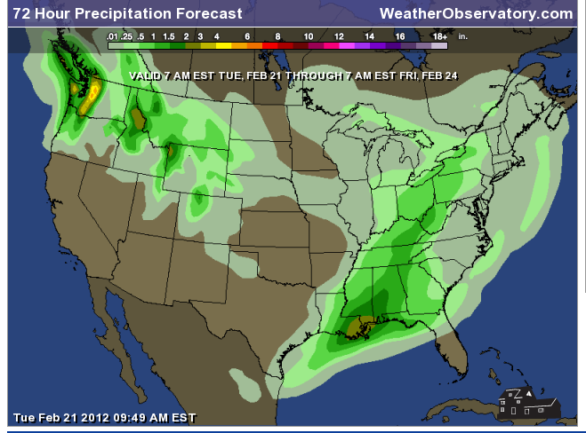
Let's check out the how much rain is forecast to fall over the next 72 hours. This map gives you a general broad brushed idea of what can be expected. Remember the scale is at the top of the map.
.
If you would like to view the most up to date 24, 48, 72, and 120 hour precipitation forecast maps then click here.
.
Keep in mind most of this rain is forecast for Thursday and Thursday night
.
.
.
If you would like to view the most up to date 24, 48, 72, and 120 hour precipitation forecast maps then click here.
.
Keep in mind most of this rain is forecast for Thursday and Thursday night
.
.
.

.
You can also now view the probability of X amount of rain (you pick the value on the web-site) in a six hour period of time. Those maps can be viewed here.
.
You can view drought maps on the Weather Observatory web-site by clicking here.
.

You can also now view the probability of X amount of rain (you pick the value on the web-site) in a six hour period of time. Those maps can be viewed here.
.
You can view drought maps on the Weather Observatory web-site by clicking here.
.
.
.
No significant snow in our forecast...
.
No significant snow in our forecast...
.
Enhanced snowfall interactive forecast maps . You can choose your total snowfall amounts above the map - time frame, as well- click here
.
Snowfall forecast maps - these are interactive maps. You can choose your total snowfall amounts above the map - time frame, as well - click here
Enhanced snowfall interactive forecast maps . You can choose your total snowfall amounts above the map - time frame, as well- click here
.
Snowfall forecast maps - these are interactive maps. You can choose your total snowfall amounts above the map - time frame, as well - click here
.
If you are looking for wintry precipitation - click here.
.
.

.
You can view the upcoming days high temperature and low temperature forecasts by clicking here - choose the day - click on your state to zoom in
You can view the upcoming days high temperature and low temperature forecasts by clicking here - choose the day - click on your state to zoom in
.
 .
. We have a number of new radars available on our Weather Observatory web-site!
---
We now offer St Louis, Mt Vernon, Evansville, Poplar Bluff, Cape Girardeau, Marion, Paducah, Hopkinsville, and Dyersburg Interactive City Radars. We also have the two regional radars and now offer you three GR Earth radars.
http://www.weatherobservatory.com/weather-radar.htm---
---
We also have a new interactive radar - you can view that radar by clicking here.
.
Want to learn more about how to use our radars? I made a how to video with more information
Click here - http://www.youtube.com/watch?v=bfLa0hI3adU
.
.
.
.
---

.
.
Date Range: February 13th-25th
Event: A more active weather pattern with several chances for precipitation.
Severe Risk: Possibly - potential for a significant event somewhere in the TN Valley region
Frozen Precipitation Risk: Uncertain - potential for a winter storm or two - will need to monitor
Details: Several shots of cold air - with warm air - battle zone likely near our region.
Confidence in my forecast: Medium
.
.
.
Remember that as a general policy, in the long range outlook, I will NOT mention severe thunderstorms more than 72 hours in advance. I will mention thunderstorm risks and I will give as many details as possible. The word severe will be reserved for the short range forecast.
.
-----------------------------
.

What are the chances for a winter weather event (see definition below - over southeast Missouri, southern Illinois, southwest Indiana, western Kentucky, northeast Arkansas, or northwest Tennessee?
.
Winter weather event would be the potential for snow - icy travel conditions with enough sleet or freezing rain to cause advisories and/or winter storm watches/warnings to be issued by the National Weather Service.
Winter STORM outlook...
.
.
Winter weather event would be the potential for snow - icy travel conditions with enough sleet or freezing rain to cause advisories and/or winter storm watches/warnings to be issued by the National Weather Service.
.
.
Wednesday - 0%
Thursday - 0% Friday - 0%
Saturday - 0%
Sunday - 0%
Saturday - 0%
Sunday - 0%
Monday - 0%
Tuesday - 0%
.
.
1. No winter weather to talk about - does that surprise anyone? Shouldn't - not after this winter that wasn't!
.
Right now the biggest concern in the long range will be a chance for showers and thunderstorms on Sunday night into Tuesday morning. I will have to fine tune the timing of that event. Some strong thunderstorms can't be ruled out - a bit too far out to make a call on severe weather. I like to reserve that for the short range part of the forecast.
.
The overall pattern looks active as we push into the next few weeks. Several storm systems to track and follow.
.
Here is the latest six to ten and eight to fourteen day temperature outlooks.
.


.
Right now the biggest concern in the long range will be a chance for showers and thunderstorms on Sunday night into Tuesday morning. I will have to fine tune the timing of that event. Some strong thunderstorms can't be ruled out - a bit too far out to make a call on severe weather. I like to reserve that for the short range part of the forecast.
.
The overall pattern looks active as we push into the next few weeks. Several storm systems to track and follow.
.
Here is the latest six to ten and eight to fourteen day temperature outlooks.
.
Now is a GREAT time to buy a NOAA All Hazards Weather Radio. Better to have one before storms strike than to be without one during an event. I recommend the Midland Model 300 NOAA All Hazards Weather Radio - that is what I use here at my house!
.
Meteorologist Beau DodsonMcCracken County Office of Emergency Management
.

.
Beau Dodson Weather - Facebook
.

To view all watches and warnings in Illinois - Click Here
To view all watches and warnings in Kentucky - Click Here
To view all watches and warnings in Missouri - Click Here
To view all watches and warnings in Tennessee - Click Here
.
All other states- Click Here
.
For the latest watches and warnings please visit your local National Weather Service Office web-site.
http://www.weather.gov/organization.php
.
Remember most of these maps can be viewed straight off of the Weather Observatory Web-Site
.

.
No comments:
Post a Comment