.
For more frequent updates check out the weather Facebook page - click here and hit like at the top of the page.
.
This page is best viewed with Mozilla Firefox. There could be issues with spacing on Internet Explorer
.

.
Wind: Calm winds.
Precipitation probability - 0% | Rainfall totals: 0" or less.
Confidence in this forecast is very high
Wind: Southerly winds at 5-10 mph.
Precipitation probability - 0% | Rainfall totals: 0"
Confidence in this forecast is high
.
Wind: Southerly winds at 5-15 mph.
Precipitation probability - 0% | Rainfall totals: 0.00"
Confidence in this forecast is very high
.
Rain enters the picture on Saturday - locally heavy rain possible. Thinking 0.75-1.00" with pockets of heavier rain possible.
.
Don't forget to sign up for the severe weather "heads up" email list - I usually email everyone before a big event - severe weather or winter storms - ice storms. Click here to join
.

.
Click Here.
.
 ----
----
The forecast for severe or extreme weather for the next 24 hours
.
The McCracken County Office of Emergency Management reminds you that owning a NOAA All Hazards Weather Radio is the best way to receive notifications of severe weather watches and warnings.
.
Remember that the National Weather Service defines a severe thunderstorm as one that produces 58 mph winds or higher, hail 1" in size or larger, and/or a tornado. More information with some slides concerning reporting severe weather - click here
.
For the most up to date severe weather outlooks - click here.
Thursday night : Severe weather is not anticipated. No snow or ice.
Thursday night: Will there be a chance for non-severe thunderstorms? No

 .
.
.
This page is best viewed with Mozilla Firefox. There could be issues with spacing on Internet Explorer
.
.
This forecast covers far southern Illinois, southeast Missouri, southwest Indiana, western Kentucky, and northwest Tennessee - for your local town/area - click here
.
Here are my current personal forecast thoughts for far southern Illinois and western Kentucky...
.
Wednesday night: Some clouds - fog possible - dense fog in some counties.
Below normal temperatures.
Lows: in the middle 30s | Normal lows for this time of the year are around 38 degrees.Below normal temperatures.
Wind: Calm winds.
Precipitation probability - 0% | Rainfall totals: 0" or less.
Confidence in this forecast is very high
.
Thursday: Some morning fog possible - dense fog in some counties. A mix of clouds and maybe some sun late in the afternoon (if we are lucky).
Above normal temperatures.
Highs: around 57-60 degrees. | Normal highs for this time of the year are around 59 degrees.Above normal temperatures.
Wind: Southerly winds at 5-10 mph.
Precipitation probability - 0% | Rainfall totals: 0"
Confidence in this forecast is high
.
Thursday night: Mostly clear skies.
Above normal temperatures.
Above normal temperatures.
Lows: in the lower 40s | Normal lows for this time of the year are around 38 degrees.
Wind: South winds at 5 mph
Precipitation probability - 0% | Rainfall totals: 0"
Confidence in this forecast is very high
Wind: South winds at 5 mph
Precipitation probability - 0% | Rainfall totals: 0"
Confidence in this forecast is very high
.
Friday: An increase of clouds late in the day. Milder.
Highs: around 64 degrees | Normal highs for this time of the year are around 58 degrees.Above normal temperatures.
Wind: Southerly winds at 5-15 mph.
Precipitation probability - 0% | Rainfall totals: 0.00"
Confidence in this forecast is very high
.
Rain enters the picture on Saturday - locally heavy rain possible. Thinking 0.75-1.00" with pockets of heavier rain possible.
.
Don't forget to sign up for the severe weather "heads up" email list - I usually email everyone before a big event - severe weather or winter storms - ice storms. Click here to join
.
.


Forecast for your local town/city - Click Here
.
..
Join me on Facebook for more frequent updates on the weather in our local areaClick Here.
.
---
The forecast for severe or extreme weather for the next 24 hours
.
The McCracken County Office of Emergency Management reminds you that owning a NOAA All Hazards Weather Radio is the best way to receive notifications of severe weather watches and warnings.
.
Remember that the National Weather Service defines a severe thunderstorm as one that produces 58 mph winds or higher, hail 1" in size or larger, and/or a tornado. More information with some slides concerning reporting severe weather - click here
.
For the most up to date severe weather outlooks - click here.
or
Visit the Storm Prediction Center's web-site - click here
.
Wednesday night: Severe weather is not anticipated. No snow or ice.
Wednesday night: Will there be a chance for non-severe thunderstorms? No
.
.
Wednesday night: Severe weather is not anticipated. No snow or ice.
Wednesday night: Will there be a chance for non-severe thunderstorms? No
.
Thursday: Severe weather is not anticipated. No snow or ice.
Thursday: Will there be a chance for non-severe thunderstorms? No
.Thursday: Will there be a chance for non-severe thunderstorms? No
Thursday night : Severe weather is not anticipated. No snow or ice.
Thursday night: Will there be a chance for non-severe thunderstorms? No
.
Friday: Severe weather is not anticipated. No snow or ice.
Friday: Will there be a risk for non-severe thunderstorms? No
.
Friday: Will there be a risk for non-severe thunderstorms? No
.
.
To view all watches and warnings in IL - Click Here
To view all watches and warnings in KY - Click Here
To view all watches and warnings in MO - Click Here
To view all watches and warnings in TN - Click Here
All other states- Click Here
To view all watches and warnings in IL - Click Here
To view all watches and warnings in KY - Click Here
To view all watches and warnings in MO - Click Here
To view all watches and warnings in TN - Click Here
All other states- Click Here
.
The links above are interactive and you can move around the United States by simply clicking on the national map - or from the pull down menu where it says regions and US States.
.
To view the interactive map - click here.
.
To view the interactive map - click here.
.
.
.
.
HEADLINE: HAPPY THANKSGIVING everyone :) - I hope that you are all able to enjoy the holiday with family and friends.
.
There could be some fog tonight - use care if that does develop.
.
No major weather to talk about right on through Friday. This is good news.
.
The next chance of rain appears on Saturday with another cold front. Locally heavy downpours will be possible in a few spots. Severe weather is not in the forecast. Rainfall totals should be in the 0.75-1.00" range.
.
The big question then becomes Sunday into Tuesday. Models have been all over the place with the development of a cut-off low on Sunday and Monday. I will keep the chance for a mixture of cold rain, snow, and sleet at less than 20% chance.
.
Latest indications are that the system will be more progressive than earlier forecast. If this is the case then we don't have to worry about too much precipitation.
.
Bottom line - chances for a frozen precipitation event remain less than 20% for Sunday into Monday. If the system does cut off then we may have to increase the chances. For now will leave it the same as yesterday - small chance. Was a bit more interesting yesterday with the solutions being spit out by the models.
.
The coldest air of the season will arrive next week - starting on Sunday into the work week - temperatures well down into the 20s are likely across the region. Would not be surprised if they were even lower in some counties. Will update that part of the forecast as we move forward.
.
It will be increasingly windy on Saturday and Sunday. Boaters use caution.
.
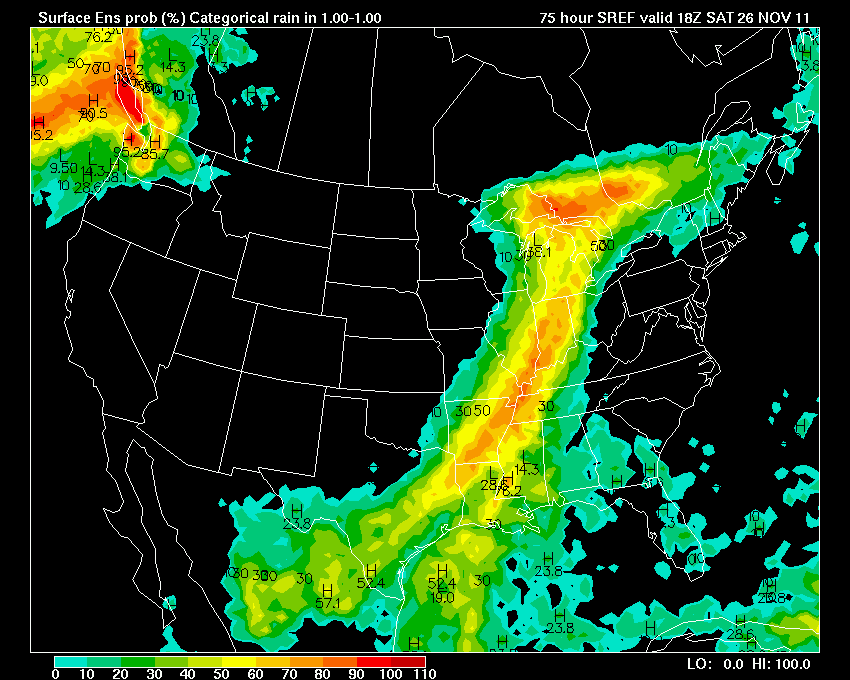
Let's pull up the SREF model - this is sort of an ensemble set of data - gives you a general idea of when the rain might arrive on Saturday. The brighter colors indicate the better chance for precipitation. You can see the cold front - obvious as it moves west to east through the area.
.
These images are from my favorite site for model data - www.wright-weather.com
.
Click each image for a real view size (I have to reduce these image sizes for the blog page)
.
The first image is for the 12 AM Saturday time frame
The second image is for the 6-7 AM Saturday time frame
The third image is for the 1-3 PM Saturday time frame
The fourth image is for the 4-7 PM Saturday time frame
The final image is after 8 PM on Saturday
.
What do these images tell us? They tell us that the best time frame for rain, assuming this model is correct, will be during the 7 AM through 4 PM time frame. This would be on Saturday.
.

.


.

.

We have a TON of new weather maps on the Weather Observatory web-site - these include temperatures, wind speed, dew points, heat index, barometric pressure, predicted rainfall, climate forecast, medium and long range maps, forecasts and more! Click here
.
-----------------------------
.

.
Let's check out the how much rain is forecast to fall over the next 48 hours. This map gives you a general broad brushed idea of what can be expected. Remember the scale is at the top of the map.
.
If you would like to view the most up to date 24, 48, 72, and 120 hour precipitation forecast maps then click here.
.

.
If you would like to view the most up to date 24, 48, 72, and 120 hour precipitation forecast maps then click here.
.
.

.
You can also now view the probability of X amount of rain (you pick the value on the web-site) in a six hour period of time. Those maps can be viewed here.
.
You can view drought maps on the Weather Observatory web-site by clicking here.
.

You can also now view the probability of X amount of rain (you pick the value on the web-site) in a six hour period of time. Those maps can be viewed here.
.
You can view drought maps on the Weather Observatory web-site by clicking here.
.
.
.
Snow is not in our local forecast through at least Saturday
.
Snow is not in our local forecast through at least Saturday
.
Enhanced snowfall interactive forecast maps . You can choose your total snowfall amounts above the map - time frame, as well- click here
.
Snowfall forecast maps - these are interactive maps. You can choose your total snowfall amounts above the map - time frame, as well - click here
Enhanced snowfall interactive forecast maps . You can choose your total snowfall amounts above the map - time frame, as well- click here
.
Snowfall forecast maps - these are interactive maps. You can choose your total snowfall amounts above the map - time frame, as well - click here
.
If you are looking for wintry precipitation - click here.
.
.

.
You can view the upcoming days high temperature and low temperature forecasts by clicking here - choose the day - click on your state to zoom in
You can view the upcoming days high temperature and low temperature forecasts by clicking here - choose the day - click on your state to zoom in
.
 .
. We have a number of new radars available on our Weather Observatory web-site!
---
We now offer St Louis, Mt Vernon, Evansville, Poplar Bluff, Cape Girardeau, Marion, Paducah, Hopkinsville, and Dyersburg Interactive City Radars. We also have the two regional radars and now offer you three GR Earth radars.
http://www.weatherobservatory.com/weather-radar.htm---
---
We also have a new interactive radar - you can view that radar by clicking here.
.
Want to learn more about how to use our radars? I made a how to video with more information
Click here - http://www.youtube.com/watch?v=bfLa0hI3adU
.
.
.
.
---

.
.
Date Range: November 26th
Event: Showers and some thunderstorms - locally heavy rain possible.
Severe Risk: Not expected
Frozen Precipitation Risk:
Details: Another in a series of storm systems will impact our region. Cold front with showers and thunderstorms - colder air behind the system. Rain may start as early as Friday night. Rainfall totals of 0.75-1.00" possible with this event. Locally higher amounts.
Confidence in my forecast: Very high
.
Date Range: November 27th -November 31st
Event: Below to much below normal temperatures. Can't rule out some mixed precipitation - low chance - but will monitor.
Severe Risk:
Frozen Precipitation Risk: Some mixed precipitation can't be ruled out
Details: Colder air arrives behind our holiday weekend storm.
Confidence in my forecast: High on the cold - low on the precipitation
.
Date Range: December 1st - December 12th
Event: Mostly below normal temperatures. Active pattern.
Severe Risk:
Frozen Precipitation Risk: Possible the first few days of the month
Details: Cold air - several shots of below normal temperatures.
Confidence in my forecast: Medium
Event: Mostly below normal temperatures. Active pattern.
Severe Risk:
Frozen Precipitation Risk: Possible the first few days of the month
Details: Cold air - several shots of below normal temperatures.
Confidence in my forecast: Medium
.
Date Range: December 27th-30th
Event: Significant storm system in the Missouri/Ohio/Tennessee Valley
Severe Risk:
Frozen Precipitation Risk:
Details: Potential precipitation event.
Confidence in my forecast: Low
.
Event: Significant storm system in the Missouri/Ohio/Tennessee Valley
Severe Risk:
Frozen Precipitation Risk:
Details: Potential precipitation event.
Confidence in my forecast: Low
.
.
Remember that as a general policy, in the long range outlook, I will NOT mention severe thunderstorms more than 72 hours in advance. I will mention thunderstorm risks and I will give as many details as possible. The word severe will be reserved for the short range forecast.
.
-----------------------------
.
1. No major changes in the extended forecast. The chance for mixed precipitation on Sunday or Monday appears low - I give it less than 20% still - no change from yesterday. The latest data moves precipitation out of our region even faster than yesterdays data. If this is the case then the chance for snow or sleet/cold rain is even less. Will monitor and update. Either way it still doesn't look like a big event - where precipitation to occur.
.
The bigger story will be the cold air next week - below normal temperatures are likely for most of the week into the following week. The coldest air of the season will occur in most or all of our counties - starting on Sunday and then into the work week.
.
I usually post these maps below when I agree with them - here is the latest six to ten day temperature outlook.
.

.
The bigger story will be the cold air next week - below normal temperatures are likely for most of the week into the following week. The coldest air of the season will occur in most or all of our counties - starting on Sunday and then into the work week.
.
I usually post these maps below when I agree with them - here is the latest six to ten day temperature outlook.
.
.
Now is a GREAT time to buy a NOAA All Hazards Weather Radio. Better to have one before storms strike than to be without one during an event. I recommend the Midland Model 300 NOAA All Hazards Weather Radio - that is what I use here at my house!
.
Meteorologist Beau DodsonMcCracken County Office of Emergency Management
.

.
Beau Dodson Weather - Facebook
.

To view all watches and warnings in Illinois - Click Here
To view all watches and warnings in Kentucky - Click Here
To view all watches and warnings in Missouri - Click Here
To view all watches and warnings in Tennessee - Click Here
.
All other states- Click Here
.
For the latest watches and warnings please visit your local National Weather Service Office web-site.
http://www.weather.gov/organization.php
.
.
Remember most of these maps can be viewed straight off of the Weather Observatory Web-Site
.

.
No comments:
Post a Comment