.
For more frequent updates check out the weather Facebook page - click here and hit like at the top of the page.
For more frequent updates check out the weather Facebook page - click here and hit like at the top of the page.
.
Video update is best viewed in full screen mode - for higher resolution.
Video update is best viewed in full screen mode - for higher resolution.
.
Don't forget to sign up for the severe weather "heads up" email list - I usually email everyone before a big event - severe weather or winter storms - ice storms. Click here to join
.This page is best viewed with Mozilla Firefox. There could be issues with spacing on Internet Explorer

.
This forecast covers far southern Illinois, southeast Missouri, southwest Indiana, western Kentucky, and northwest Tennessee - for your local town/area - click here
.
Here are my current personal forecast thoughts for far southern Illinois and western Kentucky...
.
Saturday night: Mostly cloudy skies. Windy. Above normal temperatures.
Lows: in the 55 degree range | Wind: South at 10-20 mph and gusts over 35 mph. Normal lows for this time of the year are around 41 degrees. Precipitation probability - 0% | Rainfall totals: 0" My confidence in this forecast is very high
.
Sunday: Windy - cloudy - a chance for a few scattered showers. Above normal temperatures.
Highs: around 68 degrees. | Wind: Southwest winds at 15-25 mph - gusts above 35 mph. Normal highs for this time of the year are around 63 degrees. Precipitation probability - 30% | Rainfall totals: Less than 0.10" My confidence in this forecast is very high
.
Sunday night: Mostly cloudy with a few showers. Above normal temperatures.
Lows: around 58 degrees | Wind: Southwest winds at 10-20 mph - gusty. Normal lows for this time of the year are around 41 degrees. Precipitation probability - 30% | Rainfall totals: Less than 0.10"
My confidence in this forecast is very high
My confidence in this forecast is very high
.
Monday: Mostly cloudy - windy at times - with a few scattered showers and thunderstorms - rain more likely Monday night. Above normal temperatures.
Highs: around 70 degrees. | Wind: Southwest winds at 15-20 mph with gusts over 30 mph. Normal highs for this time of the year are around 63 degrees. Precipitation probability - 30% | Rainfall totals: Less than 0.10" (day only) heavier totals will occur later Monday evening into Tuesday - with widespread 1-2" rainfall totals - locally heavier in a few counties My confidence in this forecast is very high
.
.

.

Boaters on the lakes - winds will be gusty into Monday. Would not be surprised to see some gusts over 35 mph. Use caution, as always.
.
 .
.
Use caution on area lakes - with gusty winds this weekend.
.

The wild card in this forecast will be whether or not a few scattered showers show up in the area as early as Saturday night.

.
.
Boaters on the lakes - winds will be gusty into Monday. Would not be surprised to see some gusts over 35 mph. Use caution, as always.
.
Use caution on area lakes - with gusty winds this weekend.
.
The wild card in this forecast will be whether or not a few scattered showers show up in the area as early as Saturday night.
.
.
No significant changes in the ongoing forecast.
.

.
Forecast for your local town/city - Click Here
.
..
Join me on Facebook for more frequent updates on the weather in our local areaClick Here
.
---

The forecast for severe or extreme weather for the next 24 hours
.
The McCracken County Office of Emergency Management reminds you that owning a NOAA All Hazards Weather Radio is the best way to receive notifications of severe weather watches and warnings.
.
Remember that the National Weather Service defines a severe thunderstorm as one that produces 58 mph winds or higher, hail 1" in size or larger, and/or a tornado. More information with some slides concerning reporting severe weather - click here
.
For the most up to date severe weather outlooks - click here.
or
Visit the Storm Prediction Center's web-site - click here
.
Saturday night: Severe weather is not anticipated. No snow or ice.
Saturday night: Will there be a chance for non-severe thunderstorms? No
.
.
Saturday night: Severe weather is not anticipated. No snow or ice.
Saturday night: Will there be a chance for non-severe thunderstorms? No
.
Sunday: Severe weather is not anticipated. No snow or ice.
Sunday: Will there be a chance for non-severe thunderstorms? No
.Sunday: Will there be a chance for non-severe thunderstorms? No
Sunday night : Severe weather is not anticipated. No snow or ice.
Sunday night: Will there be a chance for non-severe thunderstorms? Can't rule out a clap of thunder with a few storms.
.
Monday: Severe weather is not anticipated. No snow or ice.
Monday: Will there be a risk for non-severe thunderstorms? A few claps of thunder possible.
Monday: Will there be a risk for non-severe thunderstorms? A few claps of thunder possible.
.

.
To view all watches and warnings in IL - Click Here
To view all watches and warnings in KY - Click Here
To view all watches and warnings in MO - Click Here
To view all watches and warnings in TN - Click Here
All other states- Click Here
To view all watches and warnings in IL - Click Here
To view all watches and warnings in KY - Click Here
To view all watches and warnings in MO - Click Here
To view all watches and warnings in TN - Click Here
All other states- Click Here
.
The links above are interactive and you can move around the United States by simply clicking on the national map - or from the pull down menu where it says regions and US States.
.
To view the interactive map - click here.
.
To view the interactive map - click here.
.
.

.
.
HEADLINE: Mild weekend - breezy as the barometric pressure isobars tighten up. The breezy southerly winds will draw in more and more moisture to the region and eventually this will lead to scattered showers by Sunday and Sunday night.
.
Winds at times could gust well over 35 mph this weekend.
.
Here is what BUFKIT is showing - this shows winds of 50 mph being tapped into on Sunday morning - however, with cloud cover, this might be a bit overdone - will have to see. Click image for real view size.
.

.
Rainfall totals on Sunday will be light - where they occur.
.
Monday night and Tuesday/Tuesday night will bring a more impressive rain event to the region. A widespread 1.00-1.50" rainfall event is likely to occur. Pockets of 2.00-2.50"+ of rain will be possible over portions of southern Indiana to western Kentucky and then east. Will need to fine tune the exact path of heaviest rain. A few claps of thunder possible. Severe weather is not anticipated at this time.
.
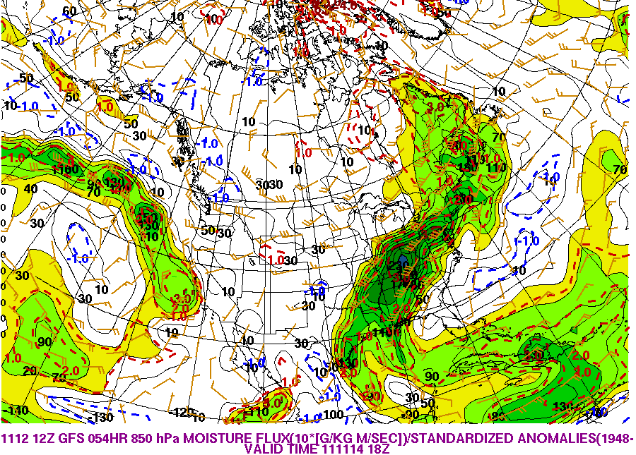
PWAT Values will be high on Monday night and Tuesday - of interest - this isn't the first time over the last few weeks that these have been pegging high to very high numbers. Also in the long range PWAT Values show higher than normal readings. This could make for heavier precipitation events. I have noticed that models have been under estimating the PWAT Values a bit and then ramp up as a storm is in the close range.
.
This image is from www.wright-weather.com - Precipitable Water Values - the second image is showing the moisture flux maps for the Monday/Tuesday event. Basically it is showing a lot of moisture in the atmosphere to wring out.
.
.

.
.
I ran some analogs on this next system and here is the map showing the chances for at least 1" of rainfall (when compared with previous storms of this type). Fairly high chances. Click image for real size view.
.

.
Temperatures will be mild right on into Monday. Cooler temperatures will return behind the next storm system on Tuesday and Wednesday. We may revisit temperatures down into the 20s later next week.
.
I do not currently see any significant ice or snow events.
.
.
We have a TON of new weather maps on the Weather Observatory web-site - these include temperatures, wind speed, dew points, heat index, barometric pressure, predicted rainfall, climate forecast, medium and long range maps, forecasts and more! Click here
.


 .
.
We have a number of new radars available on our Weather Observatory web-site!
---
We now offer St Louis, Mt Vernon, Evansville, Poplar Bluff, Cape Girardeau, Marion, Paducah, Hopkinsville, and Dyersburg Interactive City Radars. We also have the two regional radars and now offer you three GR Earth radars.
http://www.weatherobservatory.com/weather-radar.htm---
---
We also have a new interactive radar - you can view that radar by clicking here.
.
-----------------------------
.
.
Let's check out the how much rain is forecast to fall over the next 120 hours. This map gives you a general broad brushed idea of what can be expected. Remember the scale is at the top of the map.
.
.
If you would like to view the most up to date 24, 48, 72, and 120 hour precipitation forecast maps then click here.
.

.
.
.
.
You can also now view the probability of X amount of rain (you pick the value on the web-site) in a six hour period of time. Those maps can be viewed here.
.
You can view drought maps on the Weather Observatory web-site by clicking here
.

You can also now view the probability of X amount of rain (you pick the value on the web-site) in a six hour period of time. Those maps can be viewed here.
.
You can view drought maps on the Weather Observatory web-site by clicking here
.
.
.
Snow is not in our local forecast.
.
.
Snow is not in our local forecast.
.
.
Enhanced snowfall interactive forecast maps . You can choose your total snowfall amounts above the map - time frame, as well- click here
.
Snowfall forecast maps - these are interactive maps. You can choose your total snowfall amounts above the map - time frame, as well - click here
Enhanced snowfall interactive forecast maps . You can choose your total snowfall amounts above the map - time frame, as well- click here
.
Snowfall forecast maps - these are interactive maps. You can choose your total snowfall amounts above the map - time frame, as well - click here
.
If you are looking for wintry precipitation - don't forget you can view these maps yourself by clicking here.
.

.
You can view the upcoming days high temperature and low temperature forecasts by clicking here - choose the day - click on your state to zoom in
.
You can view the upcoming days high temperature and low temperature forecasts by clicking here - choose the day - click on your state to zoom in
.
.
. We have a number of new radars available on our Weather Observatory web-site!
---
We now offer St Louis, Mt Vernon, Evansville, Poplar Bluff, Cape Girardeau, Marion, Paducah, Hopkinsville, and Dyersburg Interactive City Radars. We also have the two regional radars and now offer you three GR Earth radars.
http://www.weatherobservatory.com/weather-radar.htm---
---
We also have a new interactive radar - you can view that radar by clicking here.
.
Want to learn more about how to use our radars? I made a how to video with more information
Click here - http://www.youtube.com/watch?v=bfLa0hI3adU
.
.
.
.
---

.
Date Range: November 19th -November 23rd
Event: Unsettled with several periods of showers and thunderstorms
Severe Risk: Too soon to forecast severe weather.
Frozen Precipitation Risk: n/a
Details: Appears wet with several low pressure areas in the central United States
Confidence: Medium
Event: Unsettled with several periods of showers and thunderstorms
Severe Risk: Too soon to forecast severe weather.
Frozen Precipitation Risk: n/a
Details: Appears wet with several low pressure areas in the central United States
Confidence: Medium
.
.
Date Range: November 25th -November 28th
Event: Active weather pattern - we will be between the cold air to the north and warm air to the south - multiple storm systems may bring several chances for showers and thunderstorms - occasional shots of cold air - cold air is building in Canada. Expect several significant cold waves towards the end of the month into first part of December.
Severe Risk: Too soon to make a forecast on severe weather
Frozen Precipitation Risk: Unknown
Details: Potential for occasional shots of cold air with an active pattern - will be near the boundary of cold/warm air - plenty of chances for rain and possible thunderstorms.
Confidence: Low
.
.
Date Range: November 28th -December 8th
Event: Below normal temperatures.
Severe Risk:
Frozen Precipitation Risk: Unknown
Details: I continue to watch the cold air building up north - the pattern favors a dump of cold air towards the end of the month and into the beginning of December.
Confidence: Low
Event: Below normal temperatures.
Severe Risk:
Frozen Precipitation Risk: Unknown
Details: I continue to watch the cold air building up north - the pattern favors a dump of cold air towards the end of the month and into the beginning of December.
Confidence: Low
.
.
.
Remember that as a general policy, in the long range outlook, I will NOT mention severe thunderstorms more than 72 hours in advance. I will mention thunderstorm risks and I will give as many details as possible. The word severe will be reserved for the short range forecast.
.
-----------------------------
.
1. Main story this coming week will be the rain chances on Monday night and Tuesday. Some showers before then - but that is the main rain maker.
.
Temperatures down into the 20s will be possible again later this week (towards Thursday)
.
Temperatures down into the 20s will be possible again later this week (towards Thursday)
.
Next system arrives around next weekend. Active pattern should continue for the next several weeks. Timing of the colder air is still in question - thinking towards the end of the month into the first week of December.
.
Here is the 850 mb moisture flux map for the event next weekend - a lot of moisture to work with - again. Click image for real view size.
.

.
Here is the 850 mb moisture flux map for the event next weekend - a lot of moisture to work with - again. Click image for real view size.
.

.
I do not see any substantial snow or ice threats in our region for this forecast period.
November is looking as if it will be a bit of a roller coaster in the temperature department - if we do end up with several deep storm systems then we would experience warm air moving up ahead of the storms and then cold air behind the systems. Analogs are showing a cold to very cold December into January and then perhaps more normal in February - with a cooler than average spring and stormy/wet spring.
.
Now is a GREAT time to buy a NOAA All Hazards Weather Radio. Better to have one before storms strike than to be without one during an event. I recommend the Midland Model 300 NOAA All Hazards Weather Radio - that is what I use here at my house!
.
Meteorologist Beau DodsonMcCracken County Office of Emergency Management
.

.
Beau Dodson Weather - Facebook
.

To view all watches and warnings in Illinois - Click Here
To view all watches and warnings in Kentucky - Click Here
To view all watches and warnings in Missouri - Click Here
To view all watches and warnings in Tennessee - Click Here
All other states- Click Here
. For the latest watches and warnings please visit your local National Weather Service Office web-sitehttp://www.weather.gov/organization.php
.
.
Remember most of these maps can be viewed straight off of the Weather Observatory Web-Site
.

.
No comments:
Post a Comment