.
.
HEADLINE: A chance for storms Tuesday night into Wednesday - then a lull on Wednesday night and Thursday - will then need to watch Thursday night into the weekend for a few more rain chances - will need to fine tune that part of the forecast.
.
There will be a chance for a few severe weather reports over the next 24 hours. Remember that the National Weather Service defines a severe thunderstorm as one that produces winds of 58 mph or greater - hail the size of quarters or larger - and/or a tornado. Frequent lightning often occurs with thunderstorms of this nature, as well..
The storms on Tuesday morning caused some minor damage in Massac County with some limbs down and a tree or two toppled. I measured 55 mph winds here on the hill in central Massac County. Also lightning caused significant damage to WSIL and a few other places in southern Illinois..
I now offer a product where you can track the probability of rain (and you can choose the amount of rain you want to observe) - those graphics can be viewed here - you can get a better idea of where each complex is forecast to track. Click here
.
Watches and warnings can be viewed here - drill down to your state - click here We have a TON of new weather maps on the Weather Observatory web-site - these include temperatures, wind speed, dew points, heat index, barometric pressure, predicted rainfall, climate forecast, medium and long range maps, forecasts and more! Click here
This page is best viewed with Mozilla Firefox. There could be issues with spacing on Internet Explorer
---

---
This forecast covers far southern Illinois, southeast Missouri, and western Kentucky - for your local town - click here.
Remainder of tonight - Tuesday night: A chance for showers and thunderstorms late tonight and into the morning hours. A few storms may produce high winds, frequent lightning, and hail. Lows: in the 64-69 degree range | Wind: East/southeast winds at 5-10 mph. Normal lows for this time of the year are around 63 degrees.
---
---
Wednesday: A chance for thunderstorms late morning and afternoon hours - a few severe storms not out of the question - especially over the eastern half of the area. Near normal temperatures.
Highs: in the 84-88 degree range. | Heat index: Values in the 84-90 degree range | Wind: Southeast winds at 10-15 mph shifting towards the west/southwest late in the day. Normal highs for this time of the year are around 84 degrees. .
Wednesday night: Partly cloudy. Near normal temperatures.Lows: around 61-66 degrees | Wind: West winds at 5-10 mph. Normal lows for this time of the year are around 63 degrees.
---
Thursday: Partly sunny. Near normal to above normal temperatures.
Highs: around 84-89 degrees | Heat index: Values in the 84 to 90 degree range | Wind: South/southwesterly winds at 10-15 mph. Normal highs for this time of the year are around 84 degrees.---
Thursday night: Partly cloudy with a slight chance for a thunderstorm after midnight. Near normal temperatures.
Lows: around 65-70 degrees | Wind: Southerly winds. Wind speeds at 5-15 mph. Normal lows for this time of the year are around 64 degrees..---
Friday: A chance for a few scattered thunderstorms. Otherwise partly cloudy skies. Near normal to above normal temperatures.
Highs: around 85-89 degrees | Heat index: Values in the 85 to 90 degree range | Wind: Southerly winds at 10-15 mph over most of the area - gusts to 20 mph possible. Normal highs for this time of the year are around 84 degrees..
..
Join me on Facebook for more frequent updates on the weather in our local areaClick Here
.
Forecast for your local town/city - Click Here
.
.
.
Also our new forecast page is finished! Just click the link below to see all of our Weather Observatory graphics - from the severe weather outlook to lake and river stages - extended outlooks - monthly outlooks - satellite - and more!.
Weather Observatory Graphics and Forecast Page
-----------------------------
.
---

The forecast for severe or extreme weather risk for the next 72 hours...
.
For the most up to date severe weather outlooks - click here.Tuesday night: Thunderstorms likely after midnight. Some of the storms may produce severe weather - meaning winds greater than 58 mph and hail to the size of quarters or larger - especially over the western and northwestern parts of the area and then towards southern Indiana and northern Kentucky..
.
Wednesday: Thunderstorms are again possible - some of the storms could produce high winds and hail. There will be a small risk for severe thunderstorms.
.
Wednesday night: No severe weather is anticipated at this time.
.
Thursday: No severe weather is anticipated at this time.
.
.
Here is the official severe weather outlook graphic for Wednesday - from the Storm Prediction Center - remember they are the ones that issue the official outlooks for severe weather. They have our region in a risk for severe storms - meaning storms that could produce winds greater than 58 mph - hail to the size of quarters or larger and tornadoes..

.

.
Significant to major flooding is likely to continue across the Missouri Valley in the coming weeks - latest river information - click here.
.
.
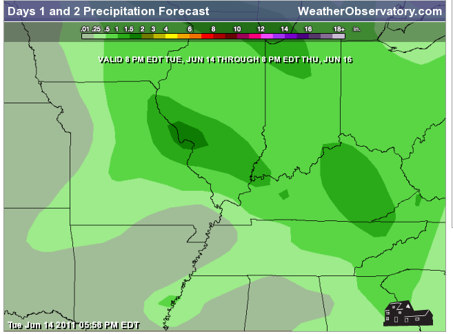
How much rain is forecast to fall over the next 48 hours? Keep in mind that this is broad brushed and individual thunderstorms can always produce locally heavy rain..
Click here for latest maps...
.
.
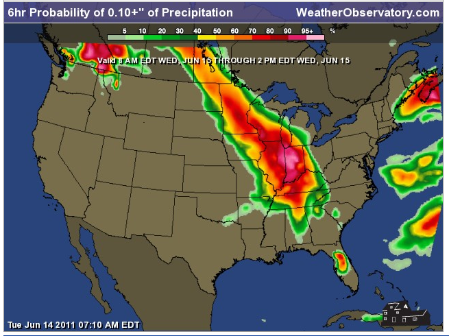
I now offer a product where you can track the probability of rain (and you can choose the amount of rain you want to observe) - those graphics can be viewed here - you can get a better idea of where each complex is forecast to track. Click here
.
Here is an example of one of those maps - the maps can be viewed in six hour time frames. This first map shows the chances for 0.10" of rain to fall between 2 am and 8 am on Wednesday morning. You can also go to the web-site link above and change the amounts to higher values. Basically this map shows you "what are the chances of it raining 0.10" at your location between 2 am and 8 am on Wednesday morning"
.

.
This next map - below - shows you what the chances of 0.10" of rain would be at your location between 8 am and 2 pm on Wednesday. Again you can find these maps by clicking here.
.
.
This next map - below - shows you what the chances of 0.10" of rain would be at your location between 2 pm and 8 pm on Wednesday. Again you can find these maps by clicking here.
.

.
And then finally from 8 pm Wednesday night through 2 am Thursday morning - you can see the rain is moving away.
.

.
Remember you can now view all of the temperature graphics (that you see below) - and more - by clicking here
.
.
Below image - Low temperatures for Wednesday morning
.

Below image - High temperatures for Wednesday afternoon
.

.
Below image - Low temperatures for Thursday morning
.

.
Below image - High temperatures for Thursday afternoon
.

.
.

Let's also take a look (the map below) at the expected heat index for tomorrow afternoon. Remember - the heat index is what the temperature feels like to your body when the temperature and humidity are combined.
.
.
You can see the heat is trying to creep back into our area - we are riding the fence - that is normally where you see a lot of shower and thunderstorm activity. On the edge of the heat ridge - see the summer forecast from the end of May for more information on that topic.
.

.
(remember you can find all of these maps on the web-site - here)
Also the UV forecast for those interested - click here
Also the UV forecast for those interested - click here
Heat safety advice and information - click here
How much above or below normal will high temperatures be tomorrow?
.
The map below shows you the departure from normal highs (normal highs are around 82-85 degrees). For example if the normal high is 80 degrees and the actual high is 90 degrees then we would be 10 degrees above normal. You can find this map on the web-site, as well - click here.
.
.

.

.

.
We have a number of new radars available on our Weather Observatory web-site!
---
We now offer St Louis, Mt Vernon, Evansville, Poplar Bluff, Cape Girardeau, Marion, Paducah, Hopkinsville, and Dyersburg Interactive City Radars. We also have the two regional radars and now offer you three GR Earth radars.
http://www.weatherobservatory.com/weather-radar.htm---
---
--------------------
.

.
You can view satellite images of the tropics by clicking here - we have a variety of satellite images available on the Weather Observatory web-site. .
Latest National Hurricane Center Tropical Outlook - click here. --------------------
---

--
You can now view the 6-10 and 8-14 day forecasts! Maps are available by clicking here.
.
Six to ten day temperature outlook - trending towards above normal temperatures overall. I think we see normal to slightly above normal temperatures - especially if we ride this boundary. The western and southern portions of the area may see the best chances for above normal temperatures.
.
These updated maps look better than the last round of maps - I think the heat ridge is trying to break down somewhat. This will help our cause for breaking the heat wave of early June. I am counting on this breaking down in order to push us into July with below normal temperatures. Hard forecast - but so far the first part of June has gone accordingly to plan. The big question has been the end of June into July.
.

.
.
8 to 14 day outlook for temperatures - again leaning towards normal to slightly above normal temperatures..

.
1. Temperatures this week will be near normal to slightly above normal. Mostly in the 80s - a better chance of 90s as you move south in the area - closer to the KY/TN border and southward. Normal high temperatures this time of the year would be around 85 degrees.
2. Thunderstorms will again likely occur on Wednesday - then a break on Thursday - then another shot late Thursday night into Friday.
.
3. Watching several disturbances over the weekend into next week that could bring additional thunderstorm chances - some of the storms could be severe next week. Still a bit early to make a call on that subject..
4. We will be watching the tropics over the coming 2 week period - there could be some type of development that moves into the Gulf of Mexico. Will monitor. .

.

You can find me on Facebook under Beau Dodson Weather - hit LIKE at the top of the page and you can follow along - also please pass the link along to your friends.
.
You can also find me on Twitter under Beau Dodson.
Don't forget that the Paducah, Kentucky US National Weather Service Office now has a Facebook page, as well! Click here and then hit LIKE at the top of their page.
---
Meteorologist Beau Dodson---
"We don't control the weather - we just predict it"
.
McCracken County Office of Emergency Management
-------------------
.

To view all watches and warnings in Illinois - Click Here
To view all watches and warnings in Kentucky - Click Here
To view all watches and warnings in Missouri - Click Here
To view all watches and warnings in Tennessee - Click Here
---
---
Other States- Click Here
http://www.weather.gov/organization.php
.

I send out emails 2-4 days in advance of widespread severe weather episodes. Basically this is a "heads up" email. If you would like to subscribe then click here.
.
For the latest watches and warnings please visit your local National Weather Service Officehttp://www.weather.gov/organization.php
.
I send out emails 2-4 days in advance of widespread severe weather episodes. Basically this is a "heads up" email. If you would like to subscribe then click here.
---
This site is non-profit and brought to you as a public service!
No comments:
Post a Comment