HEADLINE: Tuesday temperatures will once again be on the warm/hot side. We will monitor an increase in moisture towards the end of the week and into the weekend. Would not be surprised to see thunderstorm chances increase through the week/weekend. A few heavy storms not out of the question.
.
.
There were over 160 record highs and record lows on Sunday - June 5th. Here is the map - record high temperatures are the red dots. Blue dots are record low temperatures. You can view the list of records by clicking here..

.
.
.
This page is best viewed with Mozilla Firefox. There could be issues with spacing on Internet Explorer
---

---
This forecast covers far southern Illinois, southeast Missouri, and western Kentucky - for your local town - click here---
Tuesday: Mostly sunny. Hot and humid. Above normal temperatures.
Highs: in the 93-95 degree range | Heat index: Values in the 98-101 range | Wind: Northerly winds at 10 mph. Normal highs are around 81 degrees. .
Tuesday night: Mostly clear and warm. Above normal temperatures.Lows: around 68-71 degrees | Wind: East winds at 10 mph. Normal lows are around 60 degrees.
---
Wednesday: Mostly sunny. Hot and humid. Well above normal temperatures.
Highs: around 92-95 degrees | Heat index: Values in the 98 to 104 range | Wind: south winds at 10-15 mph. Normal highs are around 81 degrees.---
Wednesday night: Mostly clear. Above normal temperatures.
Lows: around 70-72 degrees | Wind: Southerly winds at 5-10 mph. Normal lows are around 60 degrees..---
Thursday: Partly sunny. Hot and humid. A small chance for showers and thunderstorms. Above normal temperatures.
Highs: around 92-95 degrees | Heat index: Values in the 98 to 101 range | Wind: southerly winds at 10-15 mph. Normal highs are around 81 degrees..
..
Join me on Facebook for more frequent updates on the weather in our local areaClick Here
.
Forecast for your local town/city - Click Here
.
.
.
Also our new forecast page is finished! Just click the link below to see all of our Weather Observatory graphics - from the severe weather outlook to lake and river stages - extended outlooks - monthly outlooks - satellite - and more!.
Weather Observatory Graphics and Forecast Page
-----------------------------
.
Remember you can now view all of the temperature graphics - and more - by clicking here
.
.
Below image - Low temperatures for Tuesday morning
.

.
Below image - High temperatures for Tuesday afternoon
Below image - High temperatures for Tuesday afternoon
.

.
Below image - High temperatures for Wednesday afternoon
.

.
.
.

Let's also take a look (the map below) at the expected heat index for tomorrow afternoon. Remember - the heat index is what the temperature feels like to your body when the temperature and humidity are combined.
.
.
.
Tuesday heat index map
.

.
(remember you can find all of these maps on the web-site - here)
Also the UV forecast for those interested
.

Also the UV forecast for those interested
.
Heat safety advice and information - click here
.
How much above normal will high temperatures be tomorrow? Several degrees! The map below shows you the departure from normal highs (normal highs are around 79-82 degrees). For example if the normal high is 80 degrees and the actual high is 90 degrees then we would be 10 degrees above normal. You can find this map on the web-site, as well - click here.
.

.

----
---
---

The forecast for severe or extreme weather risk for today, tonight, and tomorrow...
Tuesday: No severe weather is anticipated. High heat index values will make it quite uncomfortable to work outside.
.
Tuesday night: No severe weather is anticipated.
.
Wednesday: No severe weather is anticipated. High heat index values will make it quite uncomfortable to work outside..
.
Wednesday Night: No severe weather is anticipated.
.
Thursday: No severe weather is anticipated. A few thunderstorms may develop in the heat of the day. Any storms that form in this kind of heat can produce isolated severe weather. Of course lightning is always a concern. High heat index values will make it quite uncomfortable to work outside.
.
.
We have a number of new radars available on our Weather Observatory web-site!---
We now offer St Louis, Mt Vernon, Evansville, Poplar Bluff, Cape Girardeau, Marion, Paducah, Hopkinsville, and Dyersburg Interactive City Radars. We also have the two regional radars and now offer you three GR Earth radars.
http://www.weatherobservatory.com/weather-radar.htm---
---
--------------------
.

.
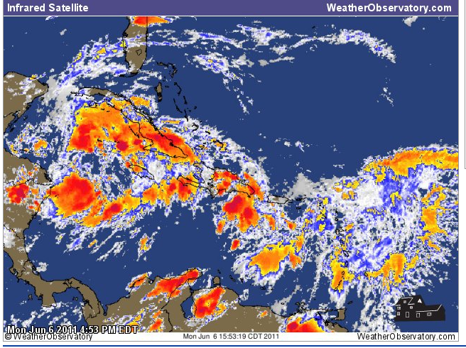
There is an area of interest in the Caribbean. The main concern is flash flooding over some of the islands. This disturbance will move slowly north/northwest in the coming days. Some slow development is not out of the question..
You can view images of the Caribbean by clicking here - we have a variety of satellite images available for you.
Caribbean system.
.
Latest National Hurricane Center Tropical Outlook - click here. --------------------
---

--
You can now view the 6-10 and 8-14 day forecasts! Maps are available by clicking here.
.
.
1. Temperatures will moderate a bit later this week and weekend.
2. Perhaps some more active weather as we push towards the middle/end of the week.
.
3. Keep in mind that my summer forecast is for an early start to summer (what we are seeing right now) and then we level off some as the ridge of high pressure shifts west into the southwest United States. That would leave us with more NW flow events - meaning our systems will move in from the St Louis region - heavy thunderstorms and squall lines. .
Drought continues to our south and southwest. We will continue to monitor that region and the tropics for any changes.You can also find me on Twitter under Beau Dodson
.
Have you joined the email list? I send out emails 2-4 days in advance of severe weather. Basically this is a "heads up" email. If you would like to subscribe then click here...
You can find me on Facebook under Beau Dodson Weather - hit LIKE at the top of the page and you can follow along - also please pass the link along to your friends.
---
Meteorologist Beau Dodson---
McCracken County Office of Emergency Management
-------------------
---
For the latest watches and warnings please visit your local National Weather Service Office
http://www.weather.gov/organization.php
---
To view all watches and warnings in Illinois- Click Here To view all watches and warnings in Kentucky - Click Here
To view all watches and warnings in Missouri - Click Here
To view all watches and warnings in Tennessee - Click Here
---
To view all watches and warnings in Tennessee - Click Here
---
Other States- Click Here
---
This site is non-profit and brought to you as a public service!
No comments:
Post a Comment