For more frequent updates check out the weather Facebook page - click here and hit like at the top of the page.
.
This page is best viewed with Mozilla Firefox. There could be issues with spacing on Internet Explorer
.

--
This forecast covers far southern Illinois, southeast Missouri, southwest Indiana, western Kentucky, and northwest Tennessee - for your local town/area - click here.
Here are my current personal forecast thoughts for far southern Illinois and western Kentucky...
.
Dry weather conditions have led to several brush fires over the last few days. Use caution if burning and check to see if your county has a burn ban in effect.
.
Thursday night: Clear. Near normal temperatures.
Lows: in the 52-56 degree range. | Wind: Calm winds. Normal lows for this time of the year are around 54 degrees. Precipitation probability - 0% .
Friday: Mostly sunny and pleasant. Above normal temperatures.
Highs: in the 79-86 degree range. | Wind: Southerly winds at 5-15 mph. Normal highs for this time of the year are around 78 degrees. Precipitation probability - 0%.
Friday night: Mostly clear. Near normal temperatures.
Lows: around 53-57 degrees | Wind: Southeast winds at 5 mph. Normal lows for this time of the year are around 54 degrees. Precipitation probability - 0%.
.
Saturday: Mostly sunny. Pleasant. Above normal temperatures.
Highs: around 79-86 degrees. | Wind: Southerly winds at 5-15 mph. Normal highs for this time of the year are around 78 degrees. Precipitation probability - 0%.

.
.
No changes. Video's are being posted again (each morning - blog is evening and video is morning)
.

.
Forecast for your local town/city - Click Here
.
..
Join me on Facebook for more frequent updates on the weather in our local areaClick Here
.
---

The forecast for severe or extreme weather risk for the next 24 hours...
.
For the most up to date severe weather outlooks - click here.or
Visit the Storm Prediction Center's web-site - click here
.
Thursday night: Severe weather is not anticipated.
Thursday night: Severe weather is not anticipated.
.
Friday: Severe weather is not anticipated.
.Friday night: Severe weather is not anticipated.
.
Saturay: Severe weather is not anticipated.
..
You can view the most up to date graphics - clicking here.
.
To view all watches and warnings in IL - Click Here
To view all watches and warnings in KY - Click Here
To view all watches and warnings in MO - Click Here
To view all watches and warnings in TN - Click Here
To view all watches and warnings in IL - Click Here
To view all watches and warnings in KY - Click Here
To view all watches and warnings in MO - Click Here
To view all watches and warnings in TN - Click Here
.
All other states- Click Here
.
The map you see below can be viewed by clicking on the watch and warnings map links above. The maps are interactive and you can move around the United States by simply clicking on the national map - or from the pull down menu where it says regions and US States - again this map is a sample map. To view the actual interactive map - click here.
.
.

HEADLINE: Well - this is just becoming ridiculous. Everyone surely is enjoying the beautiful fall weather conditions? Incredible would be a great word to describe this pattern. Calm - quiet - no drama. Just the way we like it. Enjoy
I don't have any dramatic weather to talk about
.
.
.
The McCracken County Office of Emergency Management reminds you that owning a NOAA Weather Radio is the best way to receive notifications of severe weather watches and warnings.
.
.

Beautiful weather will continue right on into the weekend. Enjoy.
-----------------------------
.

.
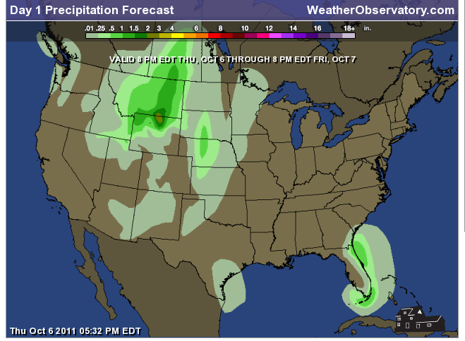
Let's check out the how much rain is forecast to fall over the next 24 hours. This map gives you a general broad brushed idea of what can be expected.
.
If you would like to view the most up to date 24, 48, 72, and 120 hour maps then click here.
.
.

.
I have added thunderstorm probabilities to the web-site - you can click hour by hour and see where the best chances for thunderstorms will exist. Here is the link - you can also choose your own region by clicking on a state.
ALSO NOW AVAILABLE - Six hour probability precipitation maps.
.
.

You can also now view the probability of X amount of rain (you pick the value on the web-site) in a six hour period of time. Those maps can be viewed here.
.
You can view the upcoming days high temperatures and low temperature forecasts by clicking here - choose the day - click on your state to zoom in - LINK
.

We have a number of new radars available on our Weather Observatory web-site!
---
We now offer St Louis, Mt Vernon, Evansville, Poplar Bluff, Cape Girardeau, Marion, Paducah, Hopkinsville, and Dyersburg Interactive City Radars. We also have the two regional radars and now offer you three GR Earth radars.
http://www.weatherobservatory.com/weather-radar.htm---
---
We also have a new interactive radar - you can view that radar by clicking here.
Want to learn more about how to use our radars? I made a how to video with more information
Click here - http://www.youtube.com/watch?v=bfLa0hI3adU
.
--------------------
.

Drought continues across a large chunk of real estate. This has been a concern for quite some time now. Droughts tend to creep. Many of you have witnessed the extreme fire conditions over portions of Texas and Oklahoma on the different news outlets. I have been watching this drought slowly creep north and east over the last few months. This will need to be monitored as we move into the fall and winter months.
.
Here is the latest Palmer Drought Index map. Severe drought continues over Texas, Oklahoma, Louisiana, and parts of Arkansas. The areas in green are moist regions - the areas in orange and yellow are in need of rain.
.

.
You can view these and more drought maps on the Weather Observatory web-site by clicking here
.

-
You can view these and more drought maps on the Weather Observatory web-site by clicking here
.
You can learn more about the current drought by visiting this Climate Prediction Center website - click here..
---
-
1. No big events in the near term forecast. Enjoy the fall like weather over the coming days.
.
Here is the latest 8-14 day outlook for precipitation - mostly below normal over a large chunk of the nation. We will be watching a couple of systems next week - whether they can hold together enough to bring us precipitation is still in question. Will monitor and update in the coming days.
.

.
Now is a GREAT time to buy a NOAA Weather Radio. Better to have one before storms strike than to be without one during an event.
.
Meteorologist Beau DodsonMcCracken County Office of Emergency Management
.

To view all watches and warnings in Illinois - Click Here
To view all watches and warnings in Kentucky - Click Here
To view all watches and warnings in Missouri - Click Here
To view all watches and warnings in Tennessee - Click Here
.
All other states- Click Here
http://www.weather.gov/organization.php
.
For the latest watches and warnings please visit your local National Weather Service Office web-sitehttp://www.weather.gov/organization.php
No comments:
Post a Comment