October 23, 2011
.
For more frequent updates check out the weather Facebook page - click here and hit like at the top of the page.
.
VIDEO IS BEST VIEWED IN FULL SCREEN MODE - It has been uploaded in high resolution
For more frequent updates check out the weather Facebook page - click here and hit like at the top of the page.
.
VIDEO IS BEST VIEWED IN FULL SCREEN MODE - It has been uploaded in high resolution
.
.
Don't forget to sign up for the severe weather "heads up" email list - I usually email everyone before a big event - severe weather or winter storms - ice storms. Click here to join
.
This page is best viewed with Mozilla Firefox. There could be issues with spacing on Internet Explorer

My confidence in this forecast is VERY high
My confidence in this forecast is VERY high
.
My confidence in this forecast is VERY high
.
.

.
.

No big concerns for the next 24 hours.
.
.
 .
.
No - nothing to worry about for the next 24 hours.
.
.
.

Wild card in this forecast will be how high the temperature will rise on Monday. Could a few counties hit 80 degrees? Upper 70s appear likely - mild for October!

Click Here
.
 ----
----
The forecast for severe or extreme weather for the next 24 hours
.
The McCracken County Office of Emergency Management reminds you that owning a NOAA All Hazards Weather Radio is the best way to receive notifications of severe weather watches and warnings.
.
Remember that the National Weather Service defines a severe thunderstorm as one that produces 58 mph winds or higher, hail 1" in size or larger, and/or a tornado. More information with some slides concerning reporting severe weather - click here
.
For the most up to date severe weather outlooks - click here.
Monday night: Severe weather is not anticipated. No snow or ice.
Monday night: Will there be a risk for non-severe thunderstorms? No .
.
HEADLINE: Wow - is anyone complaining about the cool temperatures on Saturday morning? I don't think so! Not after the brilliant late morning and afternoon hours - temperatures rose into the 60s. Can't complain about 60s with sunshine.
Don't forget to sign up for the severe weather "heads up" email list - I usually email everyone before a big event - severe weather or winter storms - ice storms. Click here to join
.
This page is best viewed with Mozilla Firefox. There could be issues with spacing on Internet Explorer
--
This forecast covers far southern Illinois, southeast Missouri, southwest Indiana, western Kentucky, and northwest Tennessee - for your local town/area - click here.
Here are my current personal forecast thoughts for far southern Illinois and western Kentucky...
.
Saturday night: A few clouds - not as cold as previous nights. Below normal temperatures.
Lows: in the 42-45 degree range. | Wind: Southwest winds at 5 mph. Normal lows for this time of the year are around 46 degrees. Precipitation probability - 0%My confidence in this forecast is VERY high
.
Sunday: Quite a few clouds through the morning - then some breaks in the clouds. Above normal temperatures.
Highs: around 70-75 degree range. | Wind: Southwest winds at 10 mph. Normal highs for this time of the year are around 70 degrees. Precipitation probability - 0%. My confidence in this forecast is VERY high
.
Sunday night: Mostly clear. Above normal temperatures.
Lows: around 50 degrees | Wind: South/southwest winds at 5 mph. Normal lows for this time of the year are around 46 degrees. Precipitation probability - 0%.
My confidence in this forecast is VERY high
My confidence in this forecast is VERY high
.
Monday: Warm - mostly sunny. Above normal temperatures.
Highs: around 75-80 degrees. | Wind: Southerly winds at 5-10 mph. Normal highs for this time of the year are around 70 degrees. Precipitation probability - 0% My confidence in this forecast is VERY high
.
.
.
.
No big concerns for the next 24 hours.
.
.
No - nothing to worry about for the next 24 hours.
.
.
.
Wild card in this forecast will be how high the temperature will rise on Monday. Could a few counties hit 80 degrees? Upper 70s appear likely - mild for October!
.

.
.
Removed the shower chance on Sunday - no big changes otherwise.
.
.
Forecast for your local town/city - Click Here
.
..
Join me on Facebook for more frequent updates on the weather in our local areaClick Here
.
---
The forecast for severe or extreme weather for the next 24 hours
.
The McCracken County Office of Emergency Management reminds you that owning a NOAA All Hazards Weather Radio is the best way to receive notifications of severe weather watches and warnings.
.
Remember that the National Weather Service defines a severe thunderstorm as one that produces 58 mph winds or higher, hail 1" in size or larger, and/or a tornado. More information with some slides concerning reporting severe weather - click here
.
For the most up to date severe weather outlooks - click here.
or
Visit the Storm Prediction Center's web-site - click here
.
Saturday night: Severe weather is not anticipated. No snow or ice.
Saturday Night: Will there be a chance for non-severe thunderstorms? No
.
.
Saturday night: Severe weather is not anticipated. No snow or ice.
Saturday Night: Will there be a chance for non-severe thunderstorms? No
.
Sunday: Severe weather is not anticipated. No snow or ice.
Sunday: Will there be a chance for non-severe thunderstorms? No
.Sunday: Will there be a chance for non-severe thunderstorms? No
Monday night: Severe weather is not anticipated. No snow or ice.
Monday night: Will there be a risk for non-severe thunderstorms? No
.
Tuesday: Severe weather is not anticipated. No snow or ice.
Tuesday: Will there be a risk for non-severe thunderstorms? No
.
.

Tuesday: Will there be a risk for non-severe thunderstorms? No
.
.
.
To view all watches and warnings in IL - Click Here
To view all watches and warnings in KY - Click Here
To view all watches and warnings in MO - Click Here
To view all watches and warnings in TN - Click Here
All other states- Click Here
To view all watches and warnings in IL - Click Here
To view all watches and warnings in KY - Click Here
To view all watches and warnings in MO - Click Here
To view all watches and warnings in TN - Click Here
All other states- Click Here
.
The links above are interactive and you can move around the United States by simply clicking on the national map - or from the pull down menu where it says regions and US States.
.
To view the interactive map - click here.
.
To view the interactive map - click here.
.
.
HEADLINE: Wow - is anyone complaining about the cool temperatures on Saturday morning? I don't think so! Not after the brilliant late morning and afternoon hours - temperatures rose into the 60s. Can't complain about 60s with sunshine.
.
I don't have any major concerns for the weather on Sunday - a few more clouds. Nice temperatures. Warm again on Monday.
.
The rain we have been talking about for the last week - is still on schedule for Tuesday night into Thursday. As a matter of fact, the latest guidance shows a fairly significant storm system once again forming just to our east on Wednesday and Thursday.
.
What does this mean for our region? It means a decent shot at rain by Tuesday night or Wednesday morning. Rain will continue into Thursday night (will need to fine tune that part of the forecast). This will be followed by windy and cooler temperatures on Thursday and Friday - into the next weekend.
.
Rainfall totals for southern Illinois and western Kentucky should be in the 0.30-0.60" range. Heavier totals possible - whether the heavy rain will fall over our local counties will need to be revisited. The exact track of the low is still in question. There is the potential for locally heavy rain if the low tracks just right. Stay tuned for updates.
.
Winds next Thursday and Friday could be gusty. Plenty of time to monitor that for any boating activities in the region.
.
-----------------------------
.

.
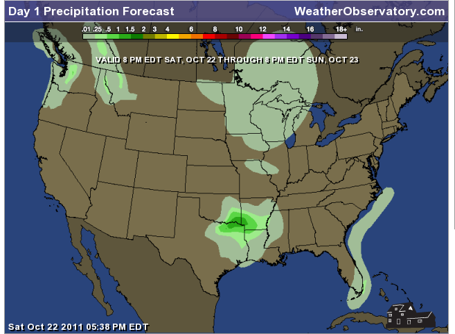
Let's check out the how much rain is forecast to fall over the next 24 hours. This map gives you a general broad brushed idea of what can be expected. Remember the scale is at the top of the map.
.
.
If you would like to view the most up to date 24, 48, 72, and 120 hour precipitation forecast maps then click here.
.
.
.

.
You can also now view the probability of X amount of rain (you pick the value on the web-site) in a six hour period of time. Those maps can be viewed here.
.
You can view drought maps on the Weather Observatory web-site by clicking here
.
.
.

You can also now view the probability of X amount of rain (you pick the value on the web-site) in a six hour period of time. Those maps can be viewed here.
.
You can view drought maps on the Weather Observatory web-site by clicking here
.
.
.
.
.
Snow is not in the forecast.
.
.
Snow is not in the forecast.
.
.
Enhanced snowfall interactive forecast maps . You can choose your total snowfall amounts above the map - time frame, as well- click here
.
Snowfall forecast maps - these are interactive maps. You can choose your total snowfall amounts above the map - time frame, as well - click here
.
.

Enhanced snowfall interactive forecast maps . You can choose your total snowfall amounts above the map - time frame, as well- click here
.
Snowfall forecast maps - these are interactive maps. You can choose your total snowfall amounts above the map - time frame, as well - click here
.
.
.
You can view the upcoming days high temperature and low temperature forecasts by clicking here - choose the day - click on your state to zoom in
.
You can view the upcoming days high temperature and low temperature forecasts by clicking here - choose the day - click on your state to zoom in
.
.
 .
. We have a number of new radars available on our Weather Observatory web-site!
---
We now offer St Louis, Mt Vernon, Evansville, Poplar Bluff, Cape Girardeau, Marion, Paducah, Hopkinsville, and Dyersburg Interactive City Radars. We also have the two regional radars and now offer you three GR Earth radars.
http://www.weatherobservatory.com/weather-radar.htm---
---
We also have a new interactive radar - you can view that radar by clicking here.
.
Want to learn more about how to use our radars? I made a how to video with more information
Click here - http://www.youtube.com/watch?v=bfLa0hI3adU
.
.
.
.
---

1. Unsettled pattern next week. The models show a deep area of low pressure pushing into the Ohio Valley. This would mean some rain (possibly some locally heavy rain) for our region towards the middle of the week and end of the week. Then followed by cooler temperatures.
.
Next weekend should be dry and cool. The next couple of weeks should bring mostly below normal temperatures. Several Canadian High Pressure systems are forecast to move into the eastern half of the United States. These high pressure systems are normally associated with cool weather (cold weather in the winter months).
.
Looking over the next 2-3 week period. I am seeing a lot of dry weather after this next storm. Will monitor - I am always concerned about the drought to our southwest spreading north and east. This has been a concern since late summer. Just something we will have to monitor. The spring forecast for 2012 is for wet/stormy conditions in our region.
.
Signals are there for a strong storm system around November 3rd-7th - will have to fine tune the timing. But just a heads up that the signals are increasing for an event around that time frame.
.
The long range pattern this winter favors below normal temperatures. There is little reason, unfortunately, to think that our extreme weather pattern is over. We have been in a pattern of extremes for the last decade.
.
Now is a GREAT time to buy a NOAA All Hazards Weather Radio. Better to have one before storms strike than to be without one during an event. I recommend the Midland Model 300 NOAA All Hazards Weather Radio.
.
Meteorologist Beau DodsonMcCracken County Office of Emergency Management
.

.
Beau Dodson Weather - Facebook
.

To view all watches and warnings in Illinois - Click Here
To view all watches and warnings in Kentucky - Click Here
To view all watches and warnings in Missouri - Click Here
To view all watches and warnings in Tennessee - Click Here
All other states- Click Here
. For the latest watches and warnings please visit your local National Weather Service Office web-sitehttp://www.weather.gov/organization.php
.
.
Remember most of these maps can be viewed straight off of the Weather Observatory Web-Site
.

.
No comments:
Post a Comment