.
For more frequent updates check out the weather Facebook page - click here and hit like at the top of the page.
.
.
Don't forget to sign up for the severe weather "heads up" email list - I usually email everyone before a big event - severe weather or winter storms - ice storms. Click here to join
.
This page is best viewed with Mozilla Firefox. There could be issues with spacing on Internet Explorer

--
This forecast covers far southern Illinois, southeast Missouri, southwest Indiana, western Kentucky, and northwest Tennessee - for your local town/area - click here.
Here are my current personal forecast thoughts for far southern Illinois and western Kentucky...
.
Wednesday night: Showers/drizzle at times - blustery - damp - raw. Below normal temperatures.
Lows: in the 37-44 degree range. | Wind: North/northwest winds at 15-25 mph with gusts over 30 mph. Normal lows for this time of the year are around 53 degrees. Precipitation probability - 80% .
Thursday: A mix of sun and clouds - windy at times. Cool. Below normal temperatures.
Highs: around 47-54 degree range. | Wind: Northwesterly winds at 10-20 mph with gusts to 30 mph - winds will taper down to 10-15 mph late in the day. Normal highs for this time of the year are around 76 degrees. Precipitation probability - 30%. .
Thursday night: A few clouds - cold - a frost and/or freeze possible in some of our counties. Below normal temperatures.
Lows: around 28-35 degrees | Wind: West/northwest winds at 5-10 mph. Normal lows for this time of the year are around 53 degrees. Precipitation probability - 0%.
.
Friday: A few clouds - cool. Below normal temperatures.
Highs: around 55-59 degrees. | Wind: Westerly winds at 5-10 mph. Normal highs for this time of the year are around 76 degrees. Precipitation probability - 0%.
.

Only concern will be frost and/or freeze on Thursday and Friday night.
.
.

The only concern will be outdoor plants - frost and/or freeze conditions Thursday night and Friday night. Also don't forget about your pets during this cold snap.
.
.
.

Wild card in this forecast will be just how cold does it become Thursday night. I believe some of our counties could experience a freeze. Frost is possible if the winds die down enough.
.

.
Updated cloud cover and tweaked temperatures - lower for Thursday night. Otherwise no major changes.
.

.
Forecast for your local town/city - Click Here
.
..
Join me on Facebook for more frequent updates on the weather in our local areaClick Here
.
---

The forecast for severe or extreme weather risk for the next 24 hours
.
The McCracken County Office of Emergency Management reminds you that owning a NOAA Weather Radio is the best way to receive notifications of severe weather watches and warnings.
.
For the most up to date severe weather outlooks - click here.
or
Visit the Storm Prediction Center's web-site - click here
.
Wednesday night: Severe weather is not anticipated. No snow or ice.
.
Wednesday night: Severe weather is not anticipated. No snow or ice.
.
Thursday: Severe weather is not anticipated. No snow or ice.
.Thursday night: Severe weather is not anticipated. No snow or ice.
.
Friday: Severe weather is not anticipated. No snow or ice.
.
.

.
.
.
To view all watches and warnings in IL - Click Here
To view all watches and warnings in KY - Click Here
To view all watches and warnings in MO - Click Here
To view all watches and warnings in TN - Click Here
All other states- Click Here
To view all watches and warnings in IL - Click Here
To view all watches and warnings in KY - Click Here
To view all watches and warnings in MO - Click Here
To view all watches and warnings in TN - Click Here
All other states- Click Here
.
The links above are interactive and you can move around the United States by simply clicking on the national map - or from the pull down menu where it says regions and US States.
.
To view the interactive map - click here.
.
To view the interactive map - click here.
.
.

HEADLINE: A powerful fall storm system (one of several to come in the weeks ahead of us) is pushing through the Ohio Valley - an impressive area of low pressure continues to deepen. Remember low pressure is associated with clouds and precipitation - typically. This low is deep enough that it is causing strong winds over our region (tight pressure gradient).
.
Thursday will bring a mix of sun and clouds - gusty winds and cool temperatures. Then the question becomes how cold will it become on Friday morning and Saturday morning. Right now I am expecting a frost and/or freeze in some of our counties on both mornings. Temperatures could dip into the upper 20s in a few counties of southeast Missouri and southern Illinois.
.
Right now Saturday appears dry - just a slight chance for a shower on Sunday. Will monitor and update tomorrow as far as the Sunday rain chance.
.
Just how much below normal will temperatures be on Thursday - if you think it is cold tomorrow then you would be right. SEVERAL degrees below normal (normal highs for this time of the year are still in the 70s)
.

.
Let's take a look at the big storm system wrapping up in the Ohio Valley - remember that low pressure areas are counterclockwise - winds wrap around them - pull air into our region from the north (thus the cooler temperatures).
.
This first image is the satellite view - check out the comma cloud. The bright red areas are cold cloud tops - meaning thunderstorms. The colder cloud tops over the Ohio Valley are where rain is falling -some of it heavy at times.
.

This next image shows you the pressure lines - isobars. This is the area of low pressure - the tight gradient (closely packed lines) are the cause of our strong winds.
.

Taking a look at the NAM Model - forecast maps for Thursday and Friday morning - you can see the deep area of low pressure to our northeast which will eventually move into Canada. The pink and blue area areas of precipitation. Map is from www.wright-weather.com
.
The first map is for Thursday morning and the second map is for Friday morning. You can tell the storm is pulling away from our region on the second map.
.
Click images for real view size
.


.
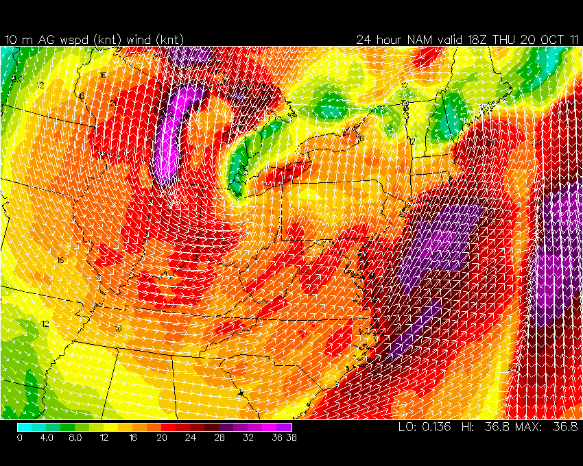
Here is the wind forecast for Thursday - from one of the NAM Model runs. Quite windy in our area - the scale is at the bottom of the page
.
.
-----------------------------
.

.
Let's check out the how much rain is forecast to fall over the next 24 hours. This map gives you a general broad brushed idea of what can be expected. Remember the scale is at the top of the map.
.
.
If you would like to view the most up to date 24, 48, 72, and 120 hour precipitation forecast maps then click here.
.

.

.
You can also now view the probability of X amount of rain (you pick the value on the web-site) in a six hour period of time. Those maps can be viewed here.
.
You can view drought maps on the Weather Observatory web-site by clicking here
.
.
.

You can also now view the probability of X amount of rain (you pick the value on the web-site) in a six hour period of time. Those maps can be viewed here.
.
You can view drought maps on the Weather Observatory web-site by clicking here
.
.
.
.
.
Snow is not in the forecast at this time.
.
.
Enhanced snowfall interactive forecast maps. You can choose your total snowfall amounts above the map - time frame, as well- click here
.
Snowfall forecast maps - these are interactive maps. You can choose your total snowfall amounts above the map - time frame, as well - click here
.
.

.
Snow is not in the forecast at this time.
.
.
Enhanced snowfall interactive forecast maps. You can choose your total snowfall amounts above the map - time frame, as well- click here
.
Snowfall forecast maps - these are interactive maps. You can choose your total snowfall amounts above the map - time frame, as well - click here
.
.
.
You can view the upcoming days high temperatures and low temperature forecasts by clicking here - choose the day - click on your state to zoom in
.
You can view the upcoming days high temperatures and low temperature forecasts by clicking here - choose the day - click on your state to zoom in
.
.
 .
.We have a number of new radars available on our Weather Observatory web-site!
---
We now offer St Louis, Mt Vernon, Evansville, Poplar Bluff, Cape Girardeau, Marion, Paducah, Hopkinsville, and Dyersburg Interactive City Radars. We also have the two regional radars and now offer you three GR Earth radars.
http://www.weatherobservatory.com/weather-radar.htm---
---
We also have a new interactive radar - you can view that radar by clicking here.
.
Want to learn more about how to use our radars? I made a how to video with more information
---

1. Cool weather is going to continue for awhile. Deep areas of low pressure will move across the eastern half of the United States over the next two week period - many of the lows appear to deepen as to move to our east. This would spell below normal temperatures for our region.
.
A lot of the moisture with the systems may stay more to our east than west. If this is the case then we may see sporadic rain chances from time to time. With each passing low pressure area we will experience cool to cold air on the backside.
.
Here is the latest six to ten day outlook for temperatures - mostly below normal for our region. The second map is the eight to fourteen day outlook - again mostly below normal for our region. Interesting pattern for this time of the year. Is this a preview of things to come? If so then you better get out the heavy coats.
.

.

Now is a GREAT time to buy a NOAA Weather Radio. Better to have one before storms strike than to be without one during an event.
.
Meteorologist Beau DodsonMcCracken County Office of Emergency Management
.

.
Beau Dodson Weather - Facebook
.

To view all watches and warnings in Illinois - Click Here
To view all watches and warnings in Kentucky - Click Here
To view all watches and warnings in Missouri - Click Here
To view all watches and warnings in Tennessee - Click Here
All other states- Click Here
http://www.weather.gov/organization.php
.
.
Remember most of these maps can be viewed straight off of the Weather Observatory Web-Site
.

.
For the latest watches and warnings please visit your local National Weather Service Office web-sitehttp://www.weather.gov/organization.php
.
.
Remember most of these maps can be viewed straight off of the Weather Observatory Web-Site
.
No comments:
Post a Comment