Thursday evening into Friday update
.
For more frequent updates check out our weather Facebook page - click here and hit like at the top of the page.
.
This page is best viewed with Mozilla Firefox. There could be issues with spacing on Internet Explorer
.

.
Here are my current personal forecast thoughts for far southern Illinois and western Kentucky...
.
Thursday night: Cloudy with a few showers overnight. Patchy fog possible. Not as mild as recent nights.
Above normal temperatures
Lows: in the lower 50s | Normal lows for this time of the year are around 38 degrees.Above normal temperatures
Wind: Southeast winds at 5 mph.
Precipitation probability - 40% | Rainfall totals: 0.25"
Confidence in this forecast is very high
.
Friday: Patchy fog early. A mix of sun and clouds. A chance for showers and thunderstorms. A few storms could produce hail.
Above normal temperatures
Highs: around 68-72 degrees. | Normal highs for this time of the year are around 59 degrees.Above normal temperatures
Wind: Southwest winds at 10-15 mph
Precipitation probability - 60% | Rainfall totals: 0.25" with pockets of heavier rain where thunderstorms occur
Confidence in this forecast is very high
.
Friday night: Partly cloudy with a chance for a few showers and thunderstorms.
Above normal temperatures
Above normal temperatures
Lows: in the upper 40s | Normal lows for this time of the year are around 38 degrees.
Wind: West to southwest winds at 5 mph
Precipitation probability - 40% | Rainfall totals: 0.25"
Confidence in this forecast is high
Wind: West to southwest winds at 5 mph
Precipitation probability - 40% | Rainfall totals: 0.25"
Confidence in this forecast is high
.
Saturday: Partly cloudy skies - a chance for a few showers and thunderstorms.
Above normal temperatures
Highs: around 65 degrees | Normal highs for this time of the year are around 59 degrees.Wind: West at 5-15 mph
Precipitation probability - 40% | Rainfall totals: 0.25" but locally heavier in thunderstorms
Confidence in this forecast is moderate
.
Don't forget to sign up for the severe weather "heads up" email list - I usually email everyone before a big event - severe weather - tornado outbreaks - winter storms - ice storms. Click here to join
.

.
.
Don't forget to sign up for the severe weather "heads up" email list - I usually email everyone before a big event - severe weather - tornado outbreaks - winter storms - ice storms. Click here to join
.
.

My main concern will be thunderstorms on Friday. Looking at all of the latest data it appears that there will at least be a chance for a few thunderstorms to become severe. The main concern will be hail. Although I can't 100% rule out a tornado - especially over parts of Indiana down into Kentucky and Tennessee. See below for more details.
.

I would suggest monitoring for changing weather conditions on Friday - in the event a few thunderstorms become severe. Hail is the main concern.
.

Wild card in this forecast will be Saturday. There is some uncertainty as to just how far this upper level low pushes east. If it is slower than expected then shower and thunderstorm chances may be a bit higher. Any sun on Saturday will cause the atmosphere to be a little more unstable. This could cause some thunderstorms to form - lightning is the main concern and also some hail. This will be conditional on whether or not the atmosphere can become unstable on Saturday.
.
.

.
Updated the severe weather forecast.
.

.
Forecast for your local town/city - Click Here
.
..
Join me on Facebook for more frequent updates on the weather in our local areaClick Here. I also strongly encourage you to FRIEND some of the local media meteorologists - I follow all of them and so should you.
.
---

The forecast for severe or extreme weather
.
The McCracken County Office of Emergency Management reminds you that owning a NOAA All Hazards Weather Radio is the best way to receive notifications of severe weather watches and warnings.
.
Remember that the National Weather Service defines a severe thunderstorm as one that produces 58 mph winds or higher, hail 1" in size or larger, and/or a tornado. More information with some slides concerning reporting severe weather - click here
.
For the most up to date severe weather outlooks - click here.
or
Visit the Storm Prediction Center's web-site - click here
.
Thursday night: Severe weather is not anticipated. No snow or ice.
Thursday night: Will there be a chance for non-severe thunderstorms? No
.
.
Thursday night: Severe weather is not anticipated. No snow or ice.
Thursday night: Will there be a chance for non-severe thunderstorms? No
.
Friday: A few thunderstorms may be severe - hail is the primary concern.
Friday: Will there be a chance for non-severe thunderstorms? Yes
.Friday: Will there be a chance for non-severe thunderstorms? Yes
Friday night : A few evening storms could produce severe weather - hail being the main concern. This would likely end before 9 pm.
Friday night: Will there be a chance for non-severe thunderstorms? Yes
.
Saturday: A couple of storms could produce some reports of hail - this is conditional on whether or not the atmosphere can become unstable on Saturday. Marginal/low risk.
Saturday: Will there be a risk for non-severe thunderstorms? Yes
.
To view storm reports from today and yesterday - click here
.
.
 .
.
Will the Storm Prediction Center issue a tornado or severe thunderstorm watch for southeast Missouri, southern Illinois, or western Kentucky?
.
Tonight - No
Friday - Possible
Saturday: Will there be a risk for non-severe thunderstorms? Yes
.
To view storm reports from today and yesterday - click here
.
.
Will the Storm Prediction Center issue a tornado or severe thunderstorm watch for southeast Missouri, southern Illinois, or western Kentucky?
.
Tonight - No
Friday - Possible
Saturday - Low chance
Sunday - No
Monday - No
Tuesday - No
.
To view the official Storm Prediction Center's web-site - click here Alternative link - click here
.
To view the official Storm Prediction Center's web-site - click here Alternative link - click here

.
To view all watches and warnings in IL - Click Here
To view all watches and warnings in KY - Click Here
To view all watches and warnings in MO - Click Here
To view all watches and warnings in TN - Click Here
All other states- Click Here
To view all watches and warnings in IL - Click Here
To view all watches and warnings in KY - Click Here
To view all watches and warnings in MO - Click Here
To view all watches and warnings in TN - Click Here
All other states- Click Here
.
The links above are interactive and you can move around the United States by simply clicking on the national map - or from the pull down menu where it says regions and US States.
.
To view the interactive warning map - click here.
.
.
 .
.
You can listen to local emergency services, SKYWARN storm spotters, and more by visiting our scanner feed page - click here
.
.
 .
.
The Weather Observatory is a strong partner with the National Weather Service - click here to visit your local NWS web-site. For the most up to date warnings/advisories hit refresh on their page.
.
To view the interactive warning map - click here.
.
.
You can listen to local emergency services, SKYWARN storm spotters, and more by visiting our scanner feed page - click here
.
.
The Weather Observatory is a strong partner with the National Weather Service - click here to visit your local NWS web-site. For the most up to date warnings/advisories hit refresh on their page.
.
.

This forecast analysis covers far southern Illinois, southeast Missouri, southwest Indiana, western Kentucky, and northwest Tennessee
.
HEADLINES: Showers overspread the area on Wednesday night and into Thursday. As I am writing this blog update I see radar showing a large area of showers from Illinois down into Kentucky and Tennessee - scattered showers also to the west. I am not seeing many reports of thunderstorms - thus far.
.
The BIG upper level low (see images below) will push out of Oklahoma and Kansas on Friday - it will move eastward into Missouri, Illinois, and Arkansas. Slowly but surely pushing eastward even further on Saturday.
.
This upper level low has very cold temperatures aloft - associated with it. When you have warm conditions at the surface and cold air aloft - you start to look for thunderstorm chances. We call this the LAPSE RATE - the greater the lapse rate the better chance for thunderstorms (under certain conditions). Also the better chance for hail.
.
Friday should provide enough instability for a few thunderstorms to become severe in or near our region. The main concern will be hail - some large hail is not out of the question. A lot of this will depend on how unstable the atmosphere becomes tomorrow. If we get some pockets of sunshine then the chance for thunderstorms will go up.
.
There will also be a little bit of turning in the atmosphere on Friday - that means an isolated tornado risk will exist. Right now the risk appears very low - it isn't zero though. I will mention it and updat the Beau Dodson Weather Facebook page if the threat changes. Monitor for updates, as always.
.
Here is the official Storm Prediction Center Severe Weather Outlook for Friday - remember that this can change a bit - they update several times a day - so check back on their site for updated outlooks (or check my Facebook page)
.
The yellow area indicates where a few severe thunderstorms may occur
.
 .
.
Bottom line...
.
Monitor for any updates on weather conditions on Friday into Friday afternoon - if the atmosphere becomes unstable enough then some thunderstorms could produce a few reports of large hail. The risk for high winds and tornadoes appears very low - not zero - but low. Again - monitor for updates.
.
Temperatures the next few days will remain ABOVE normal - surprise surprise.
.
Let's take a look at some of what I talked about above - in graphic form below!
.
Here is the visible satellite view showing the 500 mb UPPER LEVEL LOW - the upper level low has very cold temperatures aloft - associated with it. You can see the circular pattern to the clouds - if you loop the satellite images on the Weather Observatory web-site you can actually see it turning counter-clockwise. See the circulation there in Kansas and Oklahoma? Then the band of clouds being pulled NORTHWARD out of the Gulf of Mexico into our region.
.

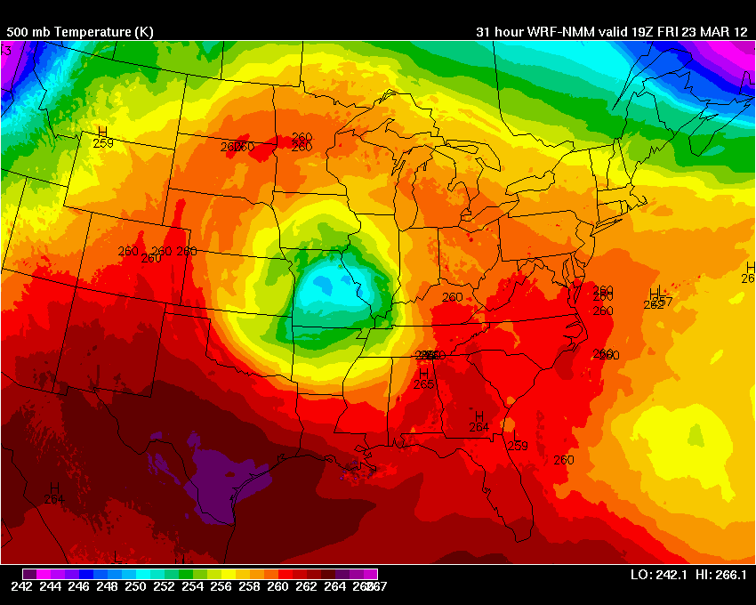
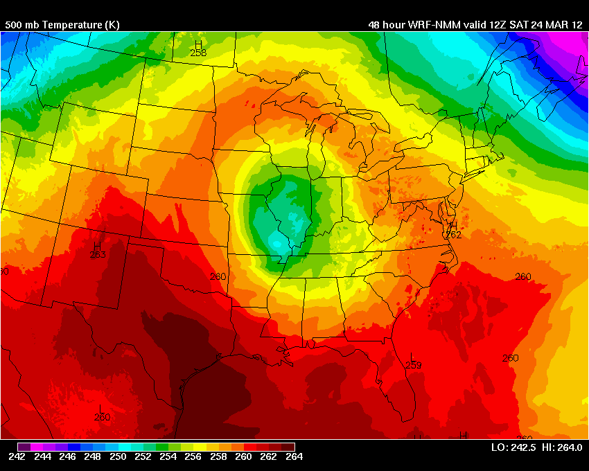
 Now let's take a look at the 500 mb temperatures - remember that the 500 mb level of the atmosphere is WAY HIGH above us - thousands of feet - 18,000 feet to be exact! Pretty high up. These 3 images below are from www.wright-weather.com - the blue colors are VERY cold temperatures.
.
This first image is from today (Thursday afternoon)
.
These three images below - click for larger view
.

.
HEADLINES: Showers overspread the area on Wednesday night and into Thursday. As I am writing this blog update I see radar showing a large area of showers from Illinois down into Kentucky and Tennessee - scattered showers also to the west. I am not seeing many reports of thunderstorms - thus far.
.
The BIG upper level low (see images below) will push out of Oklahoma and Kansas on Friday - it will move eastward into Missouri, Illinois, and Arkansas. Slowly but surely pushing eastward even further on Saturday.
.
This upper level low has very cold temperatures aloft - associated with it. When you have warm conditions at the surface and cold air aloft - you start to look for thunderstorm chances. We call this the LAPSE RATE - the greater the lapse rate the better chance for thunderstorms (under certain conditions). Also the better chance for hail.
.
Friday should provide enough instability for a few thunderstorms to become severe in or near our region. The main concern will be hail - some large hail is not out of the question. A lot of this will depend on how unstable the atmosphere becomes tomorrow. If we get some pockets of sunshine then the chance for thunderstorms will go up.
.
There will also be a little bit of turning in the atmosphere on Friday - that means an isolated tornado risk will exist. Right now the risk appears very low - it isn't zero though. I will mention it and updat the Beau Dodson Weather Facebook page if the threat changes. Monitor for updates, as always.
.
Here is the official Storm Prediction Center Severe Weather Outlook for Friday - remember that this can change a bit - they update several times a day - so check back on their site for updated outlooks (or check my Facebook page)
.
The yellow area indicates where a few severe thunderstorms may occur
.
Bottom line...
.
Monitor for any updates on weather conditions on Friday into Friday afternoon - if the atmosphere becomes unstable enough then some thunderstorms could produce a few reports of large hail. The risk for high winds and tornadoes appears very low - not zero - but low. Again - monitor for updates.
.
Temperatures the next few days will remain ABOVE normal - surprise surprise.
.
Let's take a look at some of what I talked about above - in graphic form below!
.
Here is the visible satellite view showing the 500 mb UPPER LEVEL LOW - the upper level low has very cold temperatures aloft - associated with it. You can see the circular pattern to the clouds - if you loop the satellite images on the Weather Observatory web-site you can actually see it turning counter-clockwise. See the circulation there in Kansas and Oklahoma? Then the band of clouds being pulled NORTHWARD out of the Gulf of Mexico into our region.
.
.
This first image is from today (Thursday afternoon)
.
These three images below - click for larger view
.

This next image is the FORECAST path of the 500 mb upper level low - you can see it slowly moving over our region (the lighter blue and green colors) - bringing with it the colder air aloft. This will help produce a few thunderstorms in our area. This forecast map below is for FRIDAY afternoon.
.
Now finally on SATURDAY - you can see the blue colors weakening somewhat as the upper level low weakens and conditions to drift near our region - slowly but surely moving away. Still close enough that a few storms could occur on Saturday, as well.
.
Now let's take a look at the LAPSE RATE'S - this map shows you that the lapse rates will be decent over our region on Friday and Saturday - anytime you have a higher number then that gives you a better idea that storms could become strong or severe if other conditions are met.
.
The higher the lapse rate the better chance for hail - under certain conditions - this map shows lapse rates in the 7-9 range for our region (the red colors). That is sufficient to produce some hail. Click image for full size view.
.

.
Speaking of HAIL - this is an image from BUFKIT software - this software allows me to look UP into the atmosphere and get what is called a PROFILE. Imagine a snapshot of the atmosphere during one segment of time - looking from the surface way way way up into the atmosphere.
.
I can look at this and see that the hail CAPE (remember that CAPE is basically energy available in the atmosphere) is pretty high tomorrow. If thunderstorms can form on Friday and get going then they could produce large hail. The area in WHITE is the HAIL CAPE - where I have pointed to - the yellow line to the right of that is CAPE - quite a bit of CAPE tomorrow, as well. Again click the image for the full size view.

.
How about the high temperatures for Friday into Sunday? Here you go - above normal!
.


.

.

.We have a TON of new weather maps on the Weather Observatory web-site - these include temperatures, wind speed, dew points, heat index, barometric pressure, predicted rainfall, climate forecast, medium and long range maps, forecasts and more! Click here
.
 .
.
We have a number of new radars available on our Weather Observatory web-site!
---
We now offer St Louis, Mt Vernon, Evansville, Poplar Bluff, Cape Girardeau, Marion, Paducah, Hopkinsville, and Dyersburg Interactive City Radars. We also have the two regional radars and now offer you three GR Earth radars.
Click here for our radar page - WEATHER RADARS---
---
We also have a new interactive radar - you can view that radar by clicking here.
. We have a number of new radars available on our Weather Observatory web-site!
---
We now offer St Louis, Mt Vernon, Evansville, Poplar Bluff, Cape Girardeau, Marion, Paducah, Hopkinsville, and Dyersburg Interactive City Radars. We also have the two regional radars and now offer you three GR Earth radars.
Click here for our radar page - WEATHER RADARS---
---
We also have a new interactive radar - you can view that radar by clicking here.
.
Want to learn more about how to use our radars? I made a how to video with more information
Click here - http://www.youtube.com/watch?v=bfLa0hI3adU
.
.
-----------------------------
.

.
Let's check out the how much rain is forecast to fall over the next 72 hours. This map gives you a general broad brushed idea of what can be expected. Remember the scale is at the top of the map.
.
If you would like to view the most up to date 24, 48, 72, and 120 hour precipitation forecast maps then click here.
.

.
If you would like to view the most up to date 24, 48, 72, and 120 hour precipitation forecast maps then click here.
.
.
.

.
You can also now view the probability of X amount of rain (you pick the value on the web-site) in a six hour period of time. Those maps can be viewed here.
.
You can view drought maps on the Weather Observatory web-site by clicking here.
.

Current conditions - including temperatures, apparent temperatures, heat index, wind chill, wind, pressure, humidity, dew points, and more - click here
.
You can also now view the probability of X amount of rain (you pick the value on the web-site) in a six hour period of time. Those maps can be viewed here.
.
You can view drought maps on the Weather Observatory web-site by clicking here.
.
Current conditions - including temperatures, apparent temperatures, heat index, wind chill, wind, pressure, humidity, dew points, and more - click here
.

.
You can view the upcoming days high temperature and low temperature forecasts by clicking here - choose the day - click on your state to zoom in
.
To view recent records that have been broken - click here
.
.
You can view the upcoming days high temperature and low temperature forecasts by clicking here - choose the day - click on your state to zoom in
.
To view recent records that have been broken - click here
.
.
---

.
Date Range: March 14th-31st
Event: 3-5 systems to monitor.
Severe Risk: Low chances for severe - mostly a hail threat - but monitor each event for updates.
Frozen Precipitation Risk: No
Details: Warm to very warm conditions will continue.
Confidence in my forecast: Medium
.
Date Range: April 13th-17th
Event: A larger scale system to impact the central United States
Severe Risk: Yes - possible event.
Frozen Precipitation Risk: No
Details: long range cycle forecast indicates the potential of a larger scale event during these dates.
Confidence in my forecast. Low
.
. Date Range: May 29th-June 3rd
Event: A larger scale system to impact the central United States
Severe Risk: Yes - possible event.
Frozen Precipitation Risk: No
Details: long range cycle forecast indicates the potential of a larger scale event during these dates.
Confidence in my forecast. Low
.
.
Remember that as a general policy, in the long range outlook, I try not to mention severe thunderstorms more than 72 hours in advance (unless the signal is so overwhelmingly convincing that it warrants a mention). I will mention thunderstorm risks and I will give as many details as possible. Also remember you can view the long range severe weather outlooks by visiting the Storm Prediction Center's web-site - click here
.
-----------------------------
.
1. The long range is showing another front moving into the area around the middle of next week - right now it does not appear to be a big severe weather producer. I will monitor.
.
Temperatures will CONTINUE to be above normal over the coming weeks. Par for the course.
.
Here is the latest 6-10 and 8-14 day temperature outlooks
.


.
Temperatures will CONTINUE to be above normal over the coming weeks. Par for the course.
.
Here is the latest 6-10 and 8-14 day temperature outlooks
.
Now is a GREAT time to buy a NOAA All Hazards Weather Radio. Better to have one before storms strike than to be without one during an event. I recommend the Midland Model 300 NOAA All Hazards Weather Radio - that is what I use here at my house!
.
Meteorologist Beau DodsonMcCracken County Office of Emergency Management
.

.
Beau Dodson Weather - Facebook
.

To view all watches and warnings in Illinois - Click Here
To view all watches and warnings in Kentucky - Click Here
To view all watches and warnings in Missouri - Click Here
To view all watches and warnings in Tennessee - Click Here
.
All other states- Click Here
.
For the latest watches and warnings please visit your local National Weather Service Office web-site.
http://www.weather.gov/organization.php
.
Remember most of the maps on the blog can be viewed on Weather Observatory Web-Site
.

.
No comments:
Post a Comment