.
DAILY VIDEOS are back (blog in the evening and video in the morning) - you can view them on my Facebook page each morning (best on full screen view) or on the Weather Observatory web-site - click here
.This page is best viewed with Mozilla Firefox. There could be issues with spacing on Internet Explorer
.

--
This forecast covers far southern Illinois, southeast Missouri, southwest Indiana, western Kentucky, and northwest Tennessee - for your local town/area - click here.
Here are my current personal forecast thoughts for far southern Illinois and western Kentucky...
.
Friday night: A few clouds. Below normal temperatures.
Lows: in the 38-44 degree range. | Wind: Northerly at 5-15 mph. Normal lows for this time of the year are around 54 degrees. Precipitation probability - 0% .
Saturday: Pleasant - a few patches of fog possible near rivers. Below normal temperatures.
Highs: in the 62-67 degree range. | Wind: Northerly winds at 10-20 mph. Normal highs for this time of the year are around 78 degrees. Precipitation probability - 0%.
Saturday night: Mostly clear and cool. Below normal temperatures.
Lows: around 36-44 degrees | Wind: North/northwest winds at 5 mph. Normal lows for this time of the year are around 54 degrees. Precipitation probability - 0%.
.
Sunday: A few clouds. Pleasant. Below normal temperatures.
Highs: around 67-73 degrees. | Wind: North winds at 10 mph - gusty. Normal highs for this time of the year are around 78 degrees. Precipitation probability - 0%.

.
.
Tweaked winds a bit - no other major changes. Video's are being posted again (each morning - blog is evening and video is morning)
.

.
Forecast for your local town/city - Click Here
.
..
Join me on Facebook for more frequent updates on the weather in our local areaClick Here
.
---

The forecast for severe or extreme weather risk for the next 24 hours...
.
For the most up to date severe weather outlooks - click here.or
Visit the Storm Prediction Center's web-site - click here
.
Friday night: Severe weather is not anticipated.
Friday night: Severe weather is not anticipated.
.
Saturday: Severe weather is not anticipated.
.Saturday night: Severe weather is not anticipated.
.
Sunday: Severe weather is not anticipated.
..
You can view the most up to date graphics - clicking here.
.
To view all watches and warnings in IL - Click Here
To view all watches and warnings in KY - Click Here
To view all watches and warnings in MO - Click Here
To view all watches and warnings in TN - Click Here
To view all watches and warnings in IL - Click Here
To view all watches and warnings in KY - Click Here
To view all watches and warnings in MO - Click Here
To view all watches and warnings in TN - Click Here
.
All other states- Click Here
.
The map you see below can be viewed by clicking on the watch and warnings map links above. The maps are interactive and you can move around the United States by simply clicking on the national map - or from the pull down menu where it says regions and US States - again this map is a sample map. To view the actual interactive map - click here.
.
.

HEADLINE: The cold front passed through the region on Thursday night. If you were outside today then I am sure you could tell a difference in the atmospheric conditions. Highs on Friday were only in the 60s and lower 70s - winds gusted out of the northwest at 10-20 mph (a few higher gusts, as well).
.
I don't have any dramatic weather to talk about - a nice weekend ahead for the region. I hope you are able to enjoy it.
.
Gardeners might be interested in knowing that temperatures may fall into the upper 30s on both Saturday and Sunday morning over portions of the region. I suspect there will be pockets of mid 30s in a few counties on Sunday morning. The temperature should only be in the 30s for a 1-3 hour period of time each morning. And - again - not everyone will dip below 40. This will be most likely in the rural areas and normal cold spots.
.
One more note for you - check out the temperature departure map for Saturday and compare it to next Wednesday's forecast map. The blue area is where temperatures will be BELOW normal (remember normal highs are in the middle to upper 70s for this time of the year) - notice the BIG switch. Below normal to much below normal on Saturday and then we move ABOVE normal for next week.
.

.

.
The McCracken County Office of Emergency Management reminds you that owning a NOAA Weather Radio is the best way to receive notifications of severe weather watches and warnings.
.
.

A cool weekend ahead for the region - some gusty winds, as well. If you are out on area lakes then just be aware of wind conditions.
-----------------------------
.

.
Let's check out the how much rain is forecast to fall over the next 24 hours. This map gives you a general broad brushed idea of what can be expected.
.
If you would like to view the most up to date 24, 48, 72, and 120 hour maps then click here.
.

.
I have added thunderstorm probabilities to the web-site - you can click hour by hour and see where the best chances for thunderstorms will exist. Here is the link - you can also choose your own region by clicking on a state.
ALSO NOW AVAILABLE - Six hour probability precipitation maps.
.
.

You can also now view the probability of X amount of rain (you pick the value on the web-site) in a six hour period of time. Those maps can be viewed here.
.
You can view the upcoming days high temperatures and low temperature forecasts by clicking here - choose the day - click on your state to zoom in - LINK
.

We have a number of new radars available on our Weather Observatory web-site!
---
We now offer St Louis, Mt Vernon, Evansville, Poplar Bluff, Cape Girardeau, Marion, Paducah, Hopkinsville, and Dyersburg Interactive City Radars. We also have the two regional radars and now offer you three GR Earth radars.
http://www.weatherobservatory.com/weather-radar.htm---
---
We also have a new interactive radar - you can view that radar by clicking here.
Want to learn more about how to use our radars? I made a how to video with more information
Click here - http://www.youtube.com/watch?v=bfLa0hI3adU
.
--------------------
.

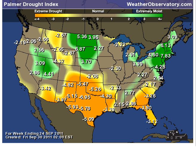
Drought continues across a large chunk of real estate. This has been a concern for quite some time now. Droughts tend to creep. Many of you have witnessed the extreme fire conditions over portions of Texas and Oklahoma on the different news outlets. I have been watching this drought slowly creep north and east over the last few months. This will need to be monitored as we move into the fall and winter months.
.
Here is the latest Palmer Drought Index. Severe drought continues over Texas, Oklahoma, Louisiana, and parts of Arkansas. The areas in green are moist regions - the areas in orange and yellow are in need of rain. The recent rains in our area have helped our cause to push back the drought to our south and west.
.
.
You can view these and more drought maps on the Weather Observatory web-site by clicking here
.

-
You can view these and more drought maps on the Weather Observatory web-site by clicking here
.
You can learn more about the current drought by visiting this Climate Prediction Center website - click here..
---
-
1. No big events in the near term forecast. Watching a system for late next week. Long way off - plenty of time to monitor. Enjoy the fall like weather over the coming days.
.
This first map below is the 6 to 10 day temperature outlook (this is for the middle and end of next week). You can see we will be shifting away from the cooler temperatures and heading back into the above normal category. The the second map is the 8 to 14 day precipitation outlook. Hints at a more active pattern?
.

.

.
We normally see an uptick during the fall months - will keep an eye. Don't forget that September is preparedness month. For more information on the different types of severe weather that can impact our region - click here.
.
Now is a GREAT time to buy a NOAA Weather Radio. Better to have one before storms strike than to be without one during an event.
.
Meteorologist Beau DodsonMcCracken County Office of Emergency Management
.

To view all watches and warnings in Illinois - Click Here
To view all watches and warnings in Kentucky - Click Here
To view all watches and warnings in Missouri - Click Here
To view all watches and warnings in Tennessee - Click Here
.
All other states- Click Here
http://www.weather.gov/organization.php
.
For the latest watches and warnings please visit your local National Weather Service Office web-sitehttp://www.weather.gov/organization.php


