.
UPDATE - 8 PM
.
A significant outbreak of severe thunderstorms and possibly tornadoes will occur on Sunday evening into Sunday night across the Ohio and Tennessee Valley.
.
Residents should closely monitor weather updates on Sunday evening into Sunday night. Numerous watches and warnings are going to be issued.
.
Storms will be moving at speeds in excess of 50 mph. This will give little advanced warning to area residents.
.
Monitor NOAA Weather Radio and local media for updated information on this event.
.
.
January 21st-22nd 2012
.
I will update the blog and the Facebook page with new information on Sunday's severe weather threat as we move forward over the next 24 hours.
.
For more frequent updates check out the weather Facebook page - click here and hit like at the top of the page.
.
This page is best viewed with Mozilla Firefox. There could be issues with spacing on Internet Explorer
.

.
This forecast covers far southern Illinois, southeast Missouri, southwest Indiana, western Kentucky, and northwest Tennessee - for your local town/area - click here
.
Here are my current personal forecast thoughts for far southern Illinois and western Kentucky...
.
Saturday night: Clouds with a chance for a few showers.
Above normal temperatures
Lows: in the upper 20s | Normal lows for this time of the year are around 26 degrees.Above normal temperatures
Wind: East winds at 5-10 mph.
Precipitation probability - 0% | Rainfall totals: 0"
Confidence in this forecast is very high
.
Sunday: A mix of sun and clouds. A chance for a shower or thunderstorm during the afternoon hours
Above normal temperatures.
Highs: around 53-58 degrees. | Normal highs for this time of the year are around 43 degrees.Above normal temperatures.
Wind: South winds at 15-30 mph and gusty at times
Precipitation probability - 40% | Rainfall totals: 0.20"
Confidence in this forecast is very high
.
Sunday night: Thunderstorms - severe thunderstorms with damaging wind, hail, and tornadoes will be possible - monitor NOAA Weather Radio and local media for the most up to date information.
Above normal temperatures
Above normal temperatures
Lows: rising temperatures into the 50s/60s then falling temperatures towards morning into the 30s | Normal lows for this time of the year are around 26 degrees.
Wind: Southerly winds at 10-20 mph becoming westerly late
Precipitation probability - 100% | Rainfall totals: 0.25"-0.75" - some higher totals likely.
Confidence in this forecast is very high
Wind: Southerly winds at 10-20 mph becoming westerly late
Precipitation probability - 100% | Rainfall totals: 0.25"-0.75" - some higher totals likely.
Confidence in this forecast is very high
.
Monday: Partly cloudy - cooler - windy at times - rain ending early
Near normal temperatures
Highs: around 46 degrees | Normal highs for this time of the year are around 43 degrees.Near normal temperatures
Wind: West winds at 10-20 mph - gusty at times
Precipitation probability - 30% early (before 5 am) | Rainfall totals: 0.10"
Confidence in this forecast is high
.
.
Don't forget to sign up for the severe weather "heads up" email list - I usually email everyone before a big event - severe weather or winter storms - ice storms. Click here to join
.

.
.
.
Don't forget to sign up for the severe weather "heads up" email list - I usually email everyone before a big event - severe weather or winter storms - ice storms. Click here to join
.
.

Concerns will entirely center around the threat for severe thunderstorms on Sunday afternoon into Sunday night (especially Sunday night). Storms could become severe with gusty winds, hail, and isolated tornadoes. The risk for severe weather will need to be fine tuned on Sunday

Possibly - stay tuned for any watches and warnings that are issued on Sunday afternoon into Sunday night. Storms will be moving rapidly northeast and east at speeds over 50 mph. This will give little advanced warning.
.

No significant wild cards in this forecast
.
.

No snow is in our short range forecast...
.

.
.
.
None
.

.
Forecast for your local town/city - Click Here
.
..
Join me on Facebook for more frequent updates on the weather in our local areaClick Here.
.
---

The forecast for severe or extreme weather for the next 48 hours
.
The McCracken County Office of Emergency Management reminds you that owning a NOAA All Hazards Weather Radio is the best way to receive notifications of severe weather watches and warnings.
.
Remember that the National Weather Service defines a severe thunderstorm as one that produces 58 mph winds or higher, hail 1" in size or larger, and/or a tornado. More information with some slides concerning reporting severe weather - click here
.
For the most up to date severe weather outlooks - click here.
or
Visit the Storm Prediction Center's web-site - click here
.
Saturday night: Severe weather is not anticipated. No snow or ice.
Saturday night: Will there be a chance for non-severe thunderstorms? No
.
.
Saturday night: Severe weather is not anticipated. No snow or ice.
Saturday night: Will there be a chance for non-severe thunderstorms? No
.
Sunday: Some severe thunderstorms will be possible on Sunday afternoon into Sunday night.
Sunday: Will there be a chance for non-severe thunderstorms? Yes
.Sunday: Will there be a chance for non-severe thunderstorms? Yes
Sunday night : Severe thunderstorms will be possible on Sunday afternoon and likely on Sunday night.
Sunday night: Will there be a chance for non-severe thunderstorms? Yes
.
Monday: Severe weather is not anticipated. No snow or ice.
Monday: Will there be a risk for non-severe thunderstorms? No
.
Monday: Will there be a risk for non-severe thunderstorms? No
.

.
To view all watches and warnings in IL - Click Here
To view all watches and warnings in KY - Click Here
To view all watches and warnings in MO - Click Here
To view all watches and warnings in TN - Click Here
All other states- Click Here
To view all watches and warnings in IL - Click Here
To view all watches and warnings in KY - Click Here
To view all watches and warnings in MO - Click Here
To view all watches and warnings in TN - Click Here
All other states- Click Here
.
The links above are interactive and you can move around the United States by simply clicking on the national map - or from the pull down menu where it says regions and US States.
.
To view the interactive map - click here.
.
To view the interactive map - click here.
.
.

.
HEADLINE: The biggest concern in the forecast is going to be a storm system that will quickly approach and intensify in the region on Sunday.
.
An area of low pressure is forecast to move across the Missouri Valley into Illinois on Sunday afternoon and Sunday night. This storm will pull moisture northward - along with warmer temperatures. Strong wind fields aloft will help fuel thunderstorms on Sunday afternoon and evening. Some of these storms could rotate because of the way wind fields are situated.
.
The Storm Prediction Center has placed most of our region in a risk for severe thunderstorms late on Sunday into Sunday night. There is some uncertainty as to where the greatest risk will be situated. Part of this will depend on the track of the area of low pressure.
.
All modes of severe weather will be possible including large hail, damaging winds, and a few tornadoes. I will need to fine tune the exact placement of the greatest threat for severe weather - check back on the blog for updates and the Facebook page for rapid updates.
.
Bottom line...
.
Showers and thunderstorms will develop in our region on Sunday afternoon and evening - some of these storms could become severe. Tornado and/or severe thunderstorm watches and warnings may be necessary for some of our counties by late on Sunday into Sunday night.
.
The uncertainty in the forecast centers around the exact placement of the most severe weather on Sunday and Sunday night - a lot of the better parameters for severe weather may come together over parts of Kentucky, Tennessee, and down into Mississippi and Alabama. This will need to be monitored. The Storm Prediction Center started shifting the threat zone westward during yesterday afternoons updates. New updates will be issued later this afternoon and tonight. This should help narrow down the highest threat region.
.
Here is the official Storm Prediction Center severe weather outlook on Sunday (again check back for updates on the Beau Dodson Weather Facebook page and/or the blog)
.
Storm spotters should closely monitor updated forecasts for possible activation on Sunday afternoon into Sunday night.
.
 Here are several images from the NAM model from www.wright-weather.com - this is a model depiction of what is expected to happen on Sunday. The NAM has yet to fully pick up on the strength of the storm system and it is believed that it is underplaying the parameters by a little bit.
.
The first couple of images indicate the Lift Index - something meteorologists look for when determining the threat for severe storms. When it goes below zero we become a bit more concerned. The dark shading is the below zero region - which we are in.
.
This is for Sunday afternoon and evening - click images for real size view
.

.

.
This next image shows you CAPE values for Sunday - you can see there is some energy with this system and it is likely to be a little higher than this model shows. Plenty of energy to fuel some storms.
.

.
The following image shows you EHI - EHI is what I look for when trying to figure out the tornado potential - you can see a spike over west Tennessee down into Mississippi


.
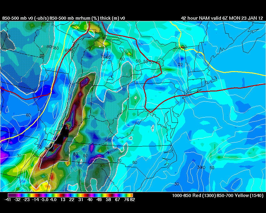
The above image shows you the 850 mb wind speeds - wind speeds above the surface of the earth - you can see some 50-65 knot winds. Plenty strong enough to help fuel thunderstorms. Click images for real size views.
.
The next few images show you where LIFT is occurring - the NAM wants to initiate thunderstorms over Missouri and Arkansas - then sweeps them east across our region. You can see that there is plenty of lift - the deeper colors that form along the cold front as it moves through our region
.
.

.


.
We have a TON of new weather maps on the Weather Observatory web-site - these include temperatures, wind speed, dew points, heat index, barometric pressure, predicted rainfall, climate forecast, medium and long range maps, forecasts and more! Click here
.
HEADLINE: The biggest concern in the forecast is going to be a storm system that will quickly approach and intensify in the region on Sunday.
.
An area of low pressure is forecast to move across the Missouri Valley into Illinois on Sunday afternoon and Sunday night. This storm will pull moisture northward - along with warmer temperatures. Strong wind fields aloft will help fuel thunderstorms on Sunday afternoon and evening. Some of these storms could rotate because of the way wind fields are situated.
.
The Storm Prediction Center has placed most of our region in a risk for severe thunderstorms late on Sunday into Sunday night. There is some uncertainty as to where the greatest risk will be situated. Part of this will depend on the track of the area of low pressure.
.
All modes of severe weather will be possible including large hail, damaging winds, and a few tornadoes. I will need to fine tune the exact placement of the greatest threat for severe weather - check back on the blog for updates and the Facebook page for rapid updates.
.
Bottom line...
.
Showers and thunderstorms will develop in our region on Sunday afternoon and evening - some of these storms could become severe. Tornado and/or severe thunderstorm watches and warnings may be necessary for some of our counties by late on Sunday into Sunday night.
.
The uncertainty in the forecast centers around the exact placement of the most severe weather on Sunday and Sunday night - a lot of the better parameters for severe weather may come together over parts of Kentucky, Tennessee, and down into Mississippi and Alabama. This will need to be monitored. The Storm Prediction Center started shifting the threat zone westward during yesterday afternoons updates. New updates will be issued later this afternoon and tonight. This should help narrow down the highest threat region.
.
Here is the official Storm Prediction Center severe weather outlook on Sunday (again check back for updates on the Beau Dodson Weather Facebook page and/or the blog)
.
Storm spotters should closely monitor updated forecasts for possible activation on Sunday afternoon into Sunday night.
.
.
The first couple of images indicate the Lift Index - something meteorologists look for when determining the threat for severe storms. When it goes below zero we become a bit more concerned. The dark shading is the below zero region - which we are in.
.
This is for Sunday afternoon and evening - click images for real size view
.

.

.
This next image shows you CAPE values for Sunday - you can see there is some energy with this system and it is likely to be a little higher than this model shows. Plenty of energy to fuel some storms.
.

.
The following image shows you EHI - EHI is what I look for when trying to figure out the tornado potential - you can see a spike over west Tennessee down into Mississippi


.
The above image shows you the 850 mb wind speeds - wind speeds above the surface of the earth - you can see some 50-65 knot winds. Plenty strong enough to help fuel thunderstorms. Click images for real size views.
.
The next few images show you where LIFT is occurring - the NAM wants to initiate thunderstorms over Missouri and Arkansas - then sweeps them east across our region. You can see that there is plenty of lift - the deeper colors that form along the cold front as it moves through our region
.
.

.

.
We have a TON of new weather maps on the Weather Observatory web-site - these include temperatures, wind speed, dew points, heat index, barometric pressure, predicted rainfall, climate forecast, medium and long range maps, forecasts and more! Click here
.
-----------------------------
.

.
Let's check out the how much rain is forecast to fall over the next 72 hours. This map gives you a general broad brushed idea of what can be expected. Remember the scale is at the top of the map.
.
If you would like to view the most up to date 24, 48, 72, and 120 hour precipitation forecast maps then click here.
.

.
If you would like to view the most up to date 24, 48, 72, and 120 hour precipitation forecast maps then click here.
.

.

.
You can also now view the probability of X amount of rain (you pick the value on the web-site) in a six hour period of time. Those maps can be viewed here.
.
You can view drought maps on the Weather Observatory web-site by clicking here.
.

You can also now view the probability of X amount of rain (you pick the value on the web-site) in a six hour period of time. Those maps can be viewed here.
.
You can view drought maps on the Weather Observatory web-site by clicking here.
.
.
.
No significant snow in our forecast...
.
No significant snow in our forecast...
.
Enhanced snowfall interactive forecast maps . You can choose your total snowfall amounts above the map - time frame, as well- click here
.
Snowfall forecast maps - these are interactive maps. You can choose your total snowfall amounts above the map - time frame, as well - click here
Enhanced snowfall interactive forecast maps . You can choose your total snowfall amounts above the map - time frame, as well- click here
.
Snowfall forecast maps - these are interactive maps. You can choose your total snowfall amounts above the map - time frame, as well - click here
.
If you are looking for wintry precipitation - click here.
.
.

.
You can view the upcoming days high temperature and low temperature forecasts by clicking here - choose the day - click on your state to zoom in
You can view the upcoming days high temperature and low temperature forecasts by clicking here - choose the day - click on your state to zoom in
.
 .
. We have a number of new radars available on our Weather Observatory web-site!
---
We now offer St Louis, Mt Vernon, Evansville, Poplar Bluff, Cape Girardeau, Marion, Paducah, Hopkinsville, and Dyersburg Interactive City Radars. We also have the two regional radars and now offer you three GR Earth radars.
http://www.weatherobservatory.com/weather-radar.htm---
---
We also have a new interactive radar - you can view that radar by clicking here.
.
Want to learn more about how to use our radars? I made a how to video with more information
Click here - http://www.youtube.com/watch?v=bfLa0hI3adU
.
.
.
.
---

.
Date Range: January 17th-February 10th
Event: Continued SWING pattern appears likely now. Potential for 5-8 precipitation events. NAO may move into neutral territory (MAYBE negative at times) - giving us the potential for a few wintry precipitation events. Some data shows periods of WELL above normal temperatures. Potential for some wild temperature swings in the coming weeks. This could mean thunderstorms during the time period, as well.
Severe Risk: Possible thunderstorms
Frozen Precipitation Risk: Possibly
Details: Potential for some significant swings in the temperature pattern.
Confidence in my forecast: Medium
.
.
Remember that as a general policy, in the long range outlook, I will NOT mention severe thunderstorms more than 72 hours in advance. I will mention thunderstorm risks and I will give as many details as possible. The word severe will be reserved for the short range forecast.
.
-----------------------------
.

What are the chances for a winter STORM event (see definition below - this DOES NOT include chances for light winter precipitation - this is for winter STORMS) over southeast Missouri, southern Illinois, southwest Indiana, western Kentucky, northeast Arkansas, or northwest Tennessee?
.
Winter STORM would be the potential for snow accumulating to 2" or more - icy travel conditions with enough sleet or freezing rain to cause advisories and/or winter storm watches/warnings to be issued by the National Weather Service.
.
Remember that as a general policy, in the long range outlook, I will NOT mention severe thunderstorms more than 72 hours in advance. I will mention thunderstorm risks and I will give as many details as possible. The word severe will be reserved for the short range forecast.
.
-----------------------------
.
I am adding an extended Winter STORM outlook...
.
.
Winter STORM would be the potential for snow accumulating to 2" or more - icy travel conditions with enough sleet or freezing rain to cause advisories and/or winter storm watches/warnings to be issued by the National Weather Service.
.
Keep in mind that the percentages DO NOT mean that is what will actually fall from the sky. It is the potential of a winter storm developing and impacting our region. The ACTUAL forecast snowfall or ice totals are only issued in the SHORT range discussion (top of the blog page)..
Monday - 0%
Tuesday - 0%
Wednesday - 5%
Thursday - 5%
Friday - 0%
.
1. No long range discussion at this time - focus is on Sunday's severe weather event.
.
Now is a GREAT time to buy a NOAA All Hazards Weather Radio. Better to have one before storms strike than to be without one during an event. I recommend the Midland Model 300 NOAA All Hazards Weather Radio - that is what I use here at my house!
.
Meteorologist Beau DodsonMcCracken County Office of Emergency Management
.

.
Beau Dodson Weather - Facebook
.

To view all watches and warnings in Illinois - Click Here
To view all watches and warnings in Kentucky - Click Here
To view all watches and warnings in Missouri - Click Here
To view all watches and warnings in Tennessee - Click Here
.
All other states- Click Here
.
For the latest watches and warnings please visit your local National Weather Service Office web-site.
http://www.weather.gov/organization.php
.
.
Remember most of these maps can be viewed straight off of the Weather Observatory Web-Site
.

.
No comments:
Post a Comment