.
For more frequent updates check out the weather Facebook page - click here and hit like at the top of the page.
.
This page is best viewed with Mozilla Firefox. There could be issues with spacing on Internet Explorer
.

.
.
Here are my current personal forecast thoughts for far southern Illinois and western Kentucky...
Here are my current personal forecast thoughts for far southern Illinois and western Kentucky...
Thursday night: Increasing clouds - not quite as cold as recent nights.
Near normal temperatures
Lows: in the middle to upper 20s - colder over our northern counties | Normal lows for this time of the year are around 26 degrees.Near normal temperatures
Wind: East/southeast winds at 5-10 mph.
Precipitation probability - 0% | Rainfall totals: 0"
Confidence in this forecast is very high
.
Friday: Mostly cloudy with a chance for a some showers late in the day - precipitation may be mixed over some of our northern and northwestern counties.
Above normal temperatures.
Above normal temperatures.
Highs: around 46 degrees - except the northern half of the region where temperatures may remain mostly in the 30s and lower 40s. | Normal highs for this time of the year are around 43 degrees.
Wind: Northeast winds at 10 mph
Precipitation probability - 40% | Rainfall totals: 0.10"
Confidence in this forecast is very high
.
Wind: Northeast winds at 10 mph
Precipitation probability - 40% | Rainfall totals: 0.10"
Confidence in this forecast is very high
.
Friday night: Cloudy with cold showers - rumble of thunder possible over Kentucky and Tennessee. A chance for a light mixture of precipitation - over our northern and northwestern counties.
Above normal temperatures
Above normal temperatures
Lows: in the lower 40s - temperatures in the 30s over parts of southeast MO and southern IL | Normal lows for this time of the year are around 26 degrees.
Wind: Northwest at 5-15 mph
Precipitation probability - 70% | Rainfall totals: 0.10"-0.20"
Confidence in this forecast is medium
Wind: Northwest at 5-15 mph
Precipitation probability - 70% | Rainfall totals: 0.10"-0.20"
Confidence in this forecast is medium
.
Saturday: Mostly cloudy sky conditions with some showers lingering. Precipitation may end as a mixture of light sleet or freezing rain. Cooler.
Near normal temperatures
Highs: around 38-42 degrees | Normal highs for this time of the year are around 43 degrees.Near normal temperatures
Wind: Northerly winds at 5-15 mph
Precipitation probability - 40% | Rainfall totals: 0.10"-0.20"
Confidence in this forecast is medium
.
.
Don't forget to sign up for the severe weather "heads up" email list - I usually email everyone before a big event - severe weather or winter storms - ice storms. Click here to join
.

.
.
.
Don't forget to sign up for the severe weather "heads up" email list - I usually email everyone before a big event - severe weather or winter storms - ice storms. Click here to join
.
.

No major concerns. I will be monitoring for the possibility of a little mixed precipitation Friday night and Saturday morning over parts of our area.

No
.

The wild card in this forecast will center around two items - temperatures and precipitation type. There will be a fairly significant difference in temperatures from north to south in our region. Temperatures will be colder along a line from Poplar Bluff to Cape Girardeau - to Mt Vernon over the next couple of days. That is a rough line - but you get the general idea.
.
The temperature difference could lead to a bit of a mixture of precipitation on Friday night and Saturday morning over parts of Missouri and Illinois. The precipitation in far southern Illinois and western Kentucky - western Tennessee should remain all rain - although right as the precipitation ends there could be a few patches of light mixed precip along and north of the Ohio River counties.
.
Confidence is fairly low as to whether frozen precipitation will materialize or if the warmer push of air will win out and change all of the precipitation to a plain old cold rain. I will update on Friday as more data arrives and as I get a better feel as to just how far north the warm air will nudge. And so this is our wild card for this update.
.
.

No significant snow is in our short range forecast...
.
There is the potential for a mixture of precipitation on Friday night and Saturday morning over the north and northwestern portions of our region - this will be in response to a weak storm system pushing through the region.
.
Right now it appears this is mostly a rain event for far southern Illinois and western Kentucky. Concern might be in the Ozarks - the hill country - and the northern portions of southern Illinois. Most likely along and north/west of a line from near Poplar Bluff to Cape Girardeau and then to Mt Vernon - rough line. Precipitation amounts would be light. However, keep in mind that even light frozen precipitation can cause some travel problems. If you are traveling on Friday and Saturday then perhaps check local road conditions and updated forecasts.
.
As the rain moves out on Saturday morning we could even see a mixture of precipitation a bit further south and east - this will need to be monitored. I will update on Friday once I get a better feel for how far north the warm air will nudge.
.

.
There is the potential for a mixture of precipitation on Friday night and Saturday morning over the north and northwestern portions of our region - this will be in response to a weak storm system pushing through the region.
.
Right now it appears this is mostly a rain event for far southern Illinois and western Kentucky. Concern might be in the Ozarks - the hill country - and the northern portions of southern Illinois. Most likely along and north/west of a line from near Poplar Bluff to Cape Girardeau and then to Mt Vernon - rough line. Precipitation amounts would be light. However, keep in mind that even light frozen precipitation can cause some travel problems. If you are traveling on Friday and Saturday then perhaps check local road conditions and updated forecasts.
.
As the rain moves out on Saturday morning we could even see a mixture of precipitation a bit further south and east - this will need to be monitored. I will update on Friday once I get a better feel for how far north the warm air will nudge.
.
.
.
No significant changes in this update. I did mention frozen precipitation potential for Friday/Saturday. Low confidence in the exact temperature profile over our region on both Friday and Saturday.
.

.
Forecast for your local town/city - Click Here
.
..
Join me on Facebook for more frequent updates on the weather in our local areaClick Here.
.
---

The forecast for severe or extreme weather for the next 48 hours
.
The McCracken County Office of Emergency Management reminds you that owning a NOAA All Hazards Weather Radio is the best way to receive notifications of severe weather watches and warnings.
.
Remember that the National Weather Service defines a severe thunderstorm as one that produces 58 mph winds or higher, hail 1" in size or larger, and/or a tornado. More information with some slides concerning reporting severe weather - click here
.
For the most up to date severe weather outlooks - click here.
or
Visit the Storm Prediction Center's web-site - click here
.
Thursday night: Severe weather is not anticipated. No snow or ice.
Thursday night: Will there be a chance for non-severe thunderstorms? No
.
.
Thursday night: Severe weather is not anticipated. No snow or ice.
Thursday night: Will there be a chance for non-severe thunderstorms? No
.
Friday: Severe weather is not anticipated. No snow or ice.
Friday: Will there be a chance for non-severe thunderstorms? No
.Friday: Will there be a chance for non-severe thunderstorms? No
Friday night : Severe weather is not anticipated. See comments on snow/ice above.
Friday night: Will there be a chance for non-severe thunderstorms? Possible rumble of thunder over the Missouri Bootheel - northeast Arkansas - Kentucky - Tennessee. An isolated severe storm possible in Tennessee (further south you go the better chance for a strong storm)
.
Saturday: Severe weather is not anticipated. See discussion above on the snow/ice.
Saturday: Will there be a risk for non-severe thunderstorms? No
.
Saturday: Will there be a risk for non-severe thunderstorms? No
.

.
To view all watches and warnings in IL - Click Here
To view all watches and warnings in KY - Click Here
To view all watches and warnings in MO - Click Here
To view all watches and warnings in TN - Click Here
All other states- Click Here
To view all watches and warnings in IL - Click Here
To view all watches and warnings in KY - Click Here
To view all watches and warnings in MO - Click Here
To view all watches and warnings in TN - Click Here
All other states- Click Here
.
The links above are interactive and you can move around the United States by simply clicking on the national map - or from the pull down menu where it says regions and US States.
.
To view the interactive map - click here.
.
To view the interactive map - click here.
.
.

.
.
This forecast analysis covers far southern Illinois, southeast Missouri, southwest Indiana, western Kentucky, and northwest Tennessee - for your local town/area - click here
.
HEADLINE: Clouds and patchy sun was the rule on Thursday across our region. Coolish temperatures after a cold front passed through the area - with no precipitation.
.
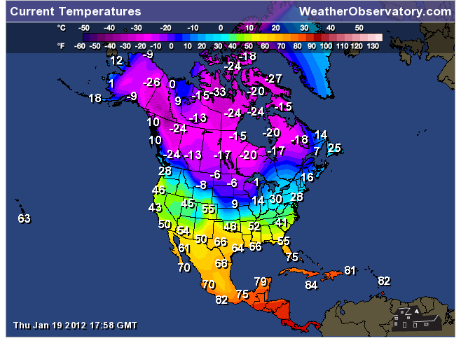
Check out the late afternoon temperatures across the Missouri and Ohio Valleys - there is definitely a frontal boundary across the region! Click image for real size view.
.

There is a fairly large temperature contrast across much of the nation, at this time. Let's take a look at that on the temperature maps from Thursday.
.
If you are viewing this blog from Canada or the Northern Plains then you are probably shivering!
.

 .
.
Thankfully the coldest air will remain bottled up to our north. I say thankfully - I know some of you are wishing for colder temperatures and some snow. Sorry about that.
.
But here is a photograph from Washington State - you might enjoy the beauty of their snow! This is from the web-site Wunderground (great weather web-site)
.
Click image for real size view!
.

.
Our next storm system will already be approaching the region by Friday and Friday afternoon. This system will bring with it a chance for rain and even a rumble of thunder. There will be a significant difference in temperatures over our region with the warmest air over Kentucky and Tennessee - colder air as you move north and west in the region.
.
Can't 100% rule out a stray severe thunderstorm over parts of Tennessee and perhaps south central Kentucky - although I believe the biggest concern will be further south. Will monitor and update on Friday. Hail and gusty winds would be the main concern. An isolated tornado threat may exist over parts of the Tennessee Valley (again watch for updates on Friday).
.
Here is the official SPC convective outlook - the yellow area represents GENERAL thunderstorms - meaning below severe levels.
.
 .
.
The difference in temperatures could mean that there will be some light snow, sleet, or freezing rain on Friday night and early Saturday morning over parts of southeast Missouri and southern Illinois - mostly along and west of a line from Poplar Bluff to Mt Vernon - perhaps a little further south and east in Illinois - but that is a rough line. The type of precipitation that falls will depend on just how far north and west the nose of warm air can filter. Sometimes cold air can be difficult to dislodge.
.
I will update on Friday as to where I believe the freezing line will reside. Confidence is low as to just how far north and west the warm air nudges on Friday and Friday night.
.
Here are the general precipitation maps for the next couple of days - again you get the general idea. Most of the rain in our region will hold off until Friday afternoon and then will last into Saturday morning - so these maps may look a bit overdone for Friday (early) and Saturday (late). But - again - you get the general idea.
.
.

 .
.
Otherwise - generally rainfall amounts will be in the 0.15"-0.40" range (heaviest precip over our eastern and southeastern counties (KY/TN) - this does not look like a big rain event. Light. A few thunderstorms will be possible over the southern half of our region - mainly over the Missouri Bootheel, northeast Arkansas, Kentucky, and Tennessee. Severe weather is not anticipated at this time.
.
Saturday and Sunday will be on the cool side - although warmer air will already be returning by Sunday ahead of another area of low pressure. Thunderstorms will be possible over the Ohio and Tennessee Valley on Sunday - some of the storms could be severe. This part of the forecast will need to be monitored and fine tuned.
.
Bottom line - right now I think the severe weather risk through the next four days will remain to our south and east. Sunday will be a close call event - a bit more moisture and instability to work with and we will have to outline a risk zone over parts of the region. Stay tuned. I will monitor and update.
,
If you live in Tennessee and Kentucky then you will want to monitor the Friday night and Sunday system a bit closer. Watch for updates over the coming days.
.
I posted this yesterday - but in case you missed it - check out these INCREDIBLE snow images from Alaska - just amazing. I suppose there is such a thing as too much snow!
.
SPEAKING of Alaska - check out this EXTREME snow video from Valdez - incredible is all I can say!
.
.
Also be sure and check out the latest information on Wednesday's tornado and severe thunderstorm outbreak that struck Indiana and Kentucky - additional storm surveys have been completed.
.
.
We have a TON of new weather maps on the Weather Observatory web-site - these include temperatures, wind speed, dew points, heat index, barometric pressure, predicted rainfall, climate forecast, medium and long range maps, forecasts and more! Click here
.
.
This forecast analysis covers far southern Illinois, southeast Missouri, southwest Indiana, western Kentucky, and northwest Tennessee - for your local town/area - click here
.
HEADLINE: Clouds and patchy sun was the rule on Thursday across our region. Coolish temperatures after a cold front passed through the area - with no precipitation.
.
Check out the late afternoon temperatures across the Missouri and Ohio Valleys - there is definitely a frontal boundary across the region! Click image for real size view.
.

There is a fairly large temperature contrast across much of the nation, at this time. Let's take a look at that on the temperature maps from Thursday.
.
If you are viewing this blog from Canada or the Northern Plains then you are probably shivering!
.
Thankfully the coldest air will remain bottled up to our north. I say thankfully - I know some of you are wishing for colder temperatures and some snow. Sorry about that.
.
But here is a photograph from Washington State - you might enjoy the beauty of their snow! This is from the web-site Wunderground (great weather web-site)
.
Click image for real size view!
.

.
Our next storm system will already be approaching the region by Friday and Friday afternoon. This system will bring with it a chance for rain and even a rumble of thunder. There will be a significant difference in temperatures over our region with the warmest air over Kentucky and Tennessee - colder air as you move north and west in the region.
.
Can't 100% rule out a stray severe thunderstorm over parts of Tennessee and perhaps south central Kentucky - although I believe the biggest concern will be further south. Will monitor and update on Friday. Hail and gusty winds would be the main concern. An isolated tornado threat may exist over parts of the Tennessee Valley (again watch for updates on Friday).
.
Here is the official SPC convective outlook - the yellow area represents GENERAL thunderstorms - meaning below severe levels.
.
The difference in temperatures could mean that there will be some light snow, sleet, or freezing rain on Friday night and early Saturday morning over parts of southeast Missouri and southern Illinois - mostly along and west of a line from Poplar Bluff to Mt Vernon - perhaps a little further south and east in Illinois - but that is a rough line. The type of precipitation that falls will depend on just how far north and west the nose of warm air can filter. Sometimes cold air can be difficult to dislodge.
.
I will update on Friday as to where I believe the freezing line will reside. Confidence is low as to just how far north and west the warm air nudges on Friday and Friday night.
.
Here are the general precipitation maps for the next couple of days - again you get the general idea. Most of the rain in our region will hold off until Friday afternoon and then will last into Saturday morning - so these maps may look a bit overdone for Friday (early) and Saturday (late). But - again - you get the general idea.
.
.
Otherwise - generally rainfall amounts will be in the 0.15"-0.40" range (heaviest precip over our eastern and southeastern counties (KY/TN) - this does not look like a big rain event. Light. A few thunderstorms will be possible over the southern half of our region - mainly over the Missouri Bootheel, northeast Arkansas, Kentucky, and Tennessee. Severe weather is not anticipated at this time.
.
Saturday and Sunday will be on the cool side - although warmer air will already be returning by Sunday ahead of another area of low pressure. Thunderstorms will be possible over the Ohio and Tennessee Valley on Sunday - some of the storms could be severe. This part of the forecast will need to be monitored and fine tuned.
.
Bottom line - right now I think the severe weather risk through the next four days will remain to our south and east. Sunday will be a close call event - a bit more moisture and instability to work with and we will have to outline a risk zone over parts of the region. Stay tuned. I will monitor and update.
,
If you live in Tennessee and Kentucky then you will want to monitor the Friday night and Sunday system a bit closer. Watch for updates over the coming days.
.
I posted this yesterday - but in case you missed it - check out these INCREDIBLE snow images from Alaska - just amazing. I suppose there is such a thing as too much snow!
.
SPEAKING of Alaska - check out this EXTREME snow video from Valdez - incredible is all I can say!
.

.
Also be sure and check out the latest information on Wednesday's tornado and severe thunderstorm outbreak that struck Indiana and Kentucky - additional storm surveys have been completed.
.

.
We have a TON of new weather maps on the Weather Observatory web-site - these include temperatures, wind speed, dew points, heat index, barometric pressure, predicted rainfall, climate forecast, medium and long range maps, forecasts and more! Click here
.
-----------------------------
.

.
Let's check out the how much rain is forecast to fall over the next 72 hours. This map gives you a general broad brushed idea of what can be expected. Remember the scale is at the top of the map.
.
If you would like to view the most up to date 24, 48, 72, and 120 hour precipitation forecast maps then click here.
.

.
If you would like to view the most up to date 24, 48, 72, and 120 hour precipitation forecast maps then click here.
.
.

.
You can also now view the probability of X amount of rain (you pick the value on the web-site) in a six hour period of time. Those maps can be viewed here.
.
You can view drought maps on the Weather Observatory web-site by clicking here.
.

You can also now view the probability of X amount of rain (you pick the value on the web-site) in a six hour period of time. Those maps can be viewed here.
.
You can view drought maps on the Weather Observatory web-site by clicking here.
.
.
.
No significant snow in our forecast...
.
No significant snow in our forecast...
.
Enhanced snowfall interactive forecast maps . You can choose your total snowfall amounts above the map - time frame, as well- click here
.
Snowfall forecast maps - these are interactive maps. You can choose your total snowfall amounts above the map - time frame, as well - click here
Enhanced snowfall interactive forecast maps . You can choose your total snowfall amounts above the map - time frame, as well- click here
.
Snowfall forecast maps - these are interactive maps. You can choose your total snowfall amounts above the map - time frame, as well - click here
.
If you are looking for wintry precipitation - click here.
.
.

.
You can view the upcoming days high temperature and low temperature forecasts by clicking here - choose the day - click on your state to zoom in
You can view the upcoming days high temperature and low temperature forecasts by clicking here - choose the day - click on your state to zoom in
.
 .
. We have a number of new radars available on our Weather Observatory web-site!
---
We now offer St Louis, Mt Vernon, Evansville, Poplar Bluff, Cape Girardeau, Marion, Paducah, Hopkinsville, and Dyersburg Interactive City Radars. We also have the two regional radars and now offer you three GR Earth radars.
http://www.weatherobservatory.com/weather-radar.htm---
---
We also have a new interactive radar - you can view that radar by clicking here.
.
Want to learn more about how to use our radars? I made a how to video with more information
Click here - http://www.youtube.com/watch?v=bfLa0hI3adU
.
.
.
.
---

.
.
Date Range: January 17th-February 10th
Event: Continued SWING pattern appears likely now. Potential for 5-8 precipitation events. NAO may move into neutral territory (MAYBE negative at times) - giving us the potential for a few wintry precipitation events. Some data shows periods of WELL above normal temperatures. Potential for some wild temperature swings in the coming weeks. This could mean thunderstorms during the time period, as well.
Severe Risk: Possible thunderstorms
Frozen Precipitation Risk: Possibly
Details: Potential for some significant swings in the temperature pattern.
Confidence in my forecast: Medium
.
.
Remember that as a general policy, in the long range outlook, I will NOT mention severe thunderstorms more than 72 hours in advance. I will mention thunderstorm risks and I will give as many details as possible. The word severe will be reserved for the short range forecast.
.
-----------------------------
.

What are the chances for a winter STORM event (see definition below - this DOES NOT include chances for light winter precipitation - this is for winter STORMS) over southeast Missouri, southern Illinois, southwest Indiana, western Kentucky, northeast Arkansas, or northwest Tennessee?
.
Winter STORM would be the potential for snow accumulating to 2" or more - icy travel conditions with enough sleet or freezing rain to cause advisories and/or winter storm watches/warnings to be issued by the National Weather Service.
.
Remember that as a general policy, in the long range outlook, I will NOT mention severe thunderstorms more than 72 hours in advance. I will mention thunderstorm risks and I will give as many details as possible. The word severe will be reserved for the short range forecast.
.
-----------------------------
.
I am adding an extended Winter STORM outlook...
.
.
Winter STORM would be the potential for snow accumulating to 2" or more - icy travel conditions with enough sleet or freezing rain to cause advisories and/or winter storm watches/warnings to be issued by the National Weather Service.
.
Keep in mind that the percentages DO NOT mean that is what will actually fall from the sky. It is the potential of a winter storm developing and impacting our region. The ACTUAL forecast snowfall or ice totals are only issued in the SHORT range discussion (top of the blog page)..
Friday - 0%
Saturday - less than 5%
Sunday - 0%
Monday - 0%
Tuesday - 0%
Wednesday - 0%
.
1. No big changes to talk about in the long range. The pattern seems to be stuck on warm - cold - warm - cold. That will continue into next week. I am watching one storm system for Sunday night into Monday - showers and possibly thunderstorms. Then another system towards the middle of next week and a third system towards next weekend. Fairly active pattern setting up for the next few weeks. I keep looking for that one big snowstorm - but I keep coming up empty handed. Sorry snow fans. Hopefully all of you who hate snow are enjoying this gift of a winter!
.
Let's take a look at the dew points on Saturday and Sunday - see how on Saturday the lower dew points invade our region - BEHIND the departing storm system. Then check out Sunday - moisture attempts to return AHEAD of the more vigorous storm system moving through Missouri. If the Sunday system had more moisture to work with then I would be concerned about strong storms - as of right now we will monitor it. I believe the bigger threat for strong storms on Sunday afternoon into Monday morning may be just to our south. But it could be close. Again - I will update on Friday and Saturday if there are any changes.
.
Images are from www.wright-weather.com - click images for larger view
.


.
Now is a GREAT time to buy a NOAA All Hazards Weather Radio. Better to have one before storms strike than to be without one during an event. I recommend the Midland Model 300 NOAA All Hazards Weather Radio - that is what I use here at my house!
.
Meteorologist Beau DodsonMcCracken County Office of Emergency Management
.

.
Beau Dodson Weather - Facebook
.

To view all watches and warnings in Illinois - Click Here
To view all watches and warnings in Kentucky - Click Here
To view all watches and warnings in Missouri - Click Here
To view all watches and warnings in Tennessee - Click Here
.
All other states- Click Here
.
For the latest watches and warnings please visit your local National Weather Service Office web-site.
http://www.weather.gov/organization.php
.
.
Remember most of these maps can be viewed straight off of the Weather Observatory Web-Site
.

.
No comments:
Post a Comment