.
First off - let me show you the brand new hydro-graph for the Ohio River at Paducah, Kentucky. Check out the nice drop in the river levels - this is great news. It can't come soon enough!.

.
.
Now to the weather!.
Showers and thunderstorms on Tuesday were confined to the areas we thought they would be - our northern and northeastern counties. Several strong/severe storms were reporting in southern Indiana and northern Kentucky.. .
Our next widespread rain event will arrive on Thursday and especially Thursday night into Friday. More rain chances for the weekend - but more spotty on Saturday vs the Thursday night/Friday event. .
A cold front will move into the area on Thursday and Friday - we will have to start thinking about a few strong/severe storms with the cold front (esp Thursday night into Friday). Gusty winds and hail are not out of the question. A few tornadoes also will be possible - especially in Missouri. I will monitor and update as the forecast becomes a bit more clear on timing and storm mode (what type of storms - supercells vs squall line)..
The threat for severe weather on Friday will depend on whether we can get some instability. Again - I will fine tune this part of the forecast. The wind fields (winds above us) are not exactly ideal for severe storms on Friday - however, there may be enough shear and wind speed to cause a few severe storms..
Speaking of instability - if you remember from reading my blog there is something forecasters call CAPE. What is CAPE? CAPE is basically ENERGY in the atmosphere. Here is a sounding (a sounding is a slice of the atmosphere at a given point in time - this point being Friday afternoon) from the NAM (the NAM is a computer forecast model that forecasts the weather)..
The area of instability is the area to the right of the right line and to the left of the red line. CAPE on this sounding is between 2000-3000 (2622 to be exact). Quite a bit of energy! If this model is correct then we will have a threat for severe storms on Friday afternoon. Still some time to fine tune that part of the forecast. Click image for larger size.
.

.
Rainfall during the Thursday through Saturday time frame should be in the 0.25-1.00" range. The heavier amounts will be associated with any strong/severe storms that do manage to move into our region.
.
Much cooler air will arrive with an upper level low over the weekend and into early next week. This cool air will be associated with quite a few clouds and some showers (possibly even some small hail as we will have a lot of cold air aloft and the freezing level may be quite low in the atmosphere). .
.
This page is best viewed with Mozilla Firefox. There could be issues with spacing on Internet Explorer
.
THANK YOU EVERYONE for all the help in our local communities - you are truly heroes!
.
---

---
This forecast covers far southern Illinois, southeast Missouri, and western Kentucky - for your local town - click here---
Wednesday: Partly sunny. Warm and humid. Above normal temperatures.
Highs: in the upper 80s | Wind: southwest winds at 5-15 mph. Normal highs are around 74-75 degrees. .
Wednesday night: Partly cloudy and mild. Above normal temperatures.Lows: around 67 degrees | Wind: southwest winds at 10 mph. Normal lows are around 52-54 degrees.
---
Thursday: Partly sunny. Scattered showers and thunderstorms. Warm and humid. Much above normal temperatures.
Highs: around 86 degrees | Wind: south winds at 10-15 mph. Normal highs are around 74-75 degrees.---
Thursday night: Showers and thunderstorms - a few storms may be on the strong side - mild. Above normal temperatures.
Lows: around 66-68 degrees | Wind: south winds at 5-15 mph. Normal lows are around 52-54 degrees..---
Friday: More clouds than sun. A chance for showers and thunderstorms. A few storms may be on the strong/severe side. Will monitor. Not as warm as recent days. Above normal temperatures.
Highs: around 75-78 degrees | Wind: south winds at 10-15 mph. Normal highs are around 74-75 degrees..
Did you know that the McCracken County Office of Emergency Management also now has a Facebook? You can view it here
.
.
Forecast for your local town/city - Click Here
.
Rivers will be slow to fall in the coming days. There will continue to be pressure on the levee systems. This is, of course, a concern.
.
Rivers will be slow to fall in the coming days. There will continue to be pressure on the levee systems. This is, of course, a concern.
.
River Stages - Click Here
.
A flood warning continues for our area - see the detailed information on watches and warnings by clicking here.
The McCracken County Office of Emergency Management reminds you that owning a NOAA Weather Radio is the best way to receive notifications of severe weather watches and warnings.
.
Also our new forecast page is finished! Just click the link below to see all of our Weather Observatory graphics - from the severe weather outlook to lake and river stages - extended outlooks - monthly outlooks - satellite - and more!.
Weather Observatory Graphics and Forecast Page
.
.


.
Need to check radar today? - click here.
.
.
.

Continued flooding. Concerns remain about the strain on levees. Be prepared for flash flooding in the event of a levee breach. Have life jackets and other emergency supplies ready for immediate deployment in the event of a breach.
Warm and humid outside - drink some extra fluids.
.
Shower and thunderstorm chances will increase on Thursday and Friday. Shower chances will continue into Saturday. Rainfall totals between Thursday and Saturday will be in the 0.25-1.00". The heavier amounts will fall where thunderstorms develop. Cooler weather will move into the area during the upcoming weekend and into early next week.
Snake bites - a number of people have reported snakes escaping the flood waters and moving into areas they are normally not seen.
Snake bites - a number of people have reported snakes escaping the flood waters and moving into areas they are normally not seen.
.
-----------------------------
-----------------------------
.
.
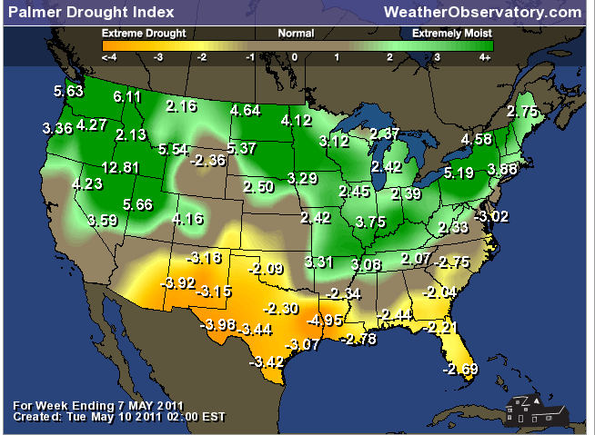
Let's take a look at the moisture anomaly and the drought index. As you can see (and as you know) we are extremely wet in our region. We are anywhere from 9 to 15+ inches above normal for the season in the rainfall department. This is quite amazing. Also note that drought does persist across areas of Oklahoma and Texas. This is one reason, we believe, for some of the capping issues (warm air aloft which prevents thunderstorms from forming) over the last few months.
.

.
.
Below is the Palmer Drought Index - basically this index measure the severity of droughts. If you recall our region was in drought last year and into the winter months. Boy - has that changed!
.
.


.
.
Below image - Low temperatures for Wednesday morning
.
..
Below image - High temperatures for Thursday afternoon
Below image - High temperatures for Thursday afternoon
.
.
Below image - High temperatures for Thursday afternoon
.
--------------------
---
---

The forecast for severe or extreme weather risk for today, tonight, and tomorrow...
Today (Wednesday) Severe weather is not anticipated. Flooding will continue.
.
Tonight (Wednesday night) Severe weather is not anticipated. Flooding will continue.
.
Thursday: A few severe thunderstorms are possible with gusty winds and hail. Isolated tornadoes can't be ruled out over Missouri and Arkansas. Will monitor and fine tune the forecast as it becomes a bit more clear. Flooding will continue on area rivers. .
.Here is the official forecast graphic from the Storm Prediction Center for Thursday's severe weather outlook. They have placed portions of our region in a slight risk for severe weather. Remember slight risk means that severe weather is likely but is not expected to be widespread in nature. I know it is a bit confusing that they use the word slight - but that is how they do it!
.
Keep in mind that this is still 48 hours out - the Storm Prediction Center (who issues these outlooks) could move this area west or east - so check back for updates..
We may have a threat for a few severe storms right on into Friday afternoon - depending on the speed of the cold front. (The graphic below is just for Thursday and does not include Friday - I will post a Friday graphic tomorrow evening).

.
Rainfall totals for the next 24 hours. .
Rainfall will be less than 0.25".
.
You can view the updated rainfall forecast maps - updated twice a day by going to the Weather Observatory Forecast Site - Click Here
.
.
We have a number of new radars available on our Weather Observatory web-site!---
We now offer St Louis, Mt Vernon, Evansville, Poplar Bluff, Cape Girardeau, Marion, Paducah, Hopkinsville, and Dyersburg Interactive City Radars. We also have the two regional radars and now offer you three GR Earth radars.
http://www.weatherobservatory.com/weather-radar.htm---
---
--------------------
.
---

--
You can now view the 6-10 and 8-14 day forecasts! Maps are available by clicking here.
.
.
Here is the medium range temperature outlook - after the warm spell over the next few days the medium range outlook is for below normal temperatures. This would be for May 15th through May 19th. .

.
Then as we look further down the road (new graphic - updated on May 10th) - May 20th through May 24th - you see temperatures start to move towards more normal values and even a bit above normal.
.

.
1. Cooler to much cooler weather is likely this coming weekend into part of next week - showers will be possible on Saturday. Temperatures will only be in the 60s later this weekend and early next week. A bit on the chilly side!
.
2. Severe weather chances may increase again around May 20th-27th. A more "spring like" storm system will bring several days of severe weather to the central and eastern United States. Potential for hail, high winds, and tornadoes. Will have to fine tune the forecast - long way off..
You can find me on Twitter under Beau Dodson
.
Have you joined the email list? I send out emails 2-4 days in advance of severe weather. Basically this is a "heads up" email. If you would like to subscribe then click here...
You can find me on Facebook under Beau Dodson Weather - hit LIKE at the top of the page and you can follow along - also please pass the link along to your friends.
---
Meteorologist Beau Dodson---
McCracken County Office of Emergency Management
---
----------------------
For the latest watches and warnings please visit your local National Weather Service Office
http://www.weather.gov/organization.php
---
To view all watches and warnings in Illinois- Click Here To view all watches and warnings in Kentucky - Click Here
To view all watches and warnings in Missouri - Click Here
To view all watches and warnings in Tennessee - Click Here
---
To view all watches and warnings in Tennessee - Click Here
---
Other States- Click Here
---
This site is non-profit and brought to you as a public service!
No comments:
Post a Comment