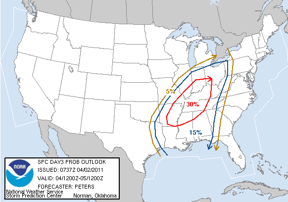
As I mentioned last night - the Storm Prediction Center had their highest probabilities too far to the west. This morning they have come back and changed their forecast. They now have the highest probabilities to our south and east for Monday (probabilities for severe weather) I will post the new map below.
WINDY today - winds are already gusting over 40 mph in our local counties. This wind will continue into this afternoon and this evening. Boaters use caution - also please don't burn any brush or other materials. Expect temperatures to rise into the upper 70s and lower 80s.
Showers and storms will increase tonight. I suspect we will all see rain and storms on Monday. A few storms may be strong or severe in the area. Stay alert for any watches or warnings.
The most severe weather should be to our west and north tonight and then on Monday to our south and east. HOWEVER, it only takes one or two severe storms in our local counties to cause problems. So - stay abreast of any changes in the forecast and possible warnings.
High winds and hail would be the primary threat with a chance for an isolated tornado.
The map below shows the NEW probability map from the Storm Prediction Center. The probabilities are the odds of seeing a severe weather event within 25 miles of any location. You can see the 30% area just clips our region now and is more to the south and east of west KY and southern IL. Still - we do have some risk for strong or severe storms. Just need to monitor updates.
---
Most of the rain and storms will roll through during the morning hours and end by late afternoon. Areas further east in KY and TN can expect the precipitation to last longer. I am still forecasting 1" of rain for most counties with a few counties picking up 1-2".

Previous Update Below
Sunday, April 3, 2011
A wind advisory has been issued for the entire area on Sunday. Winds will be gusting from 30-45 mph. Boaters should use caution.
---
This site is best viewed with Mozilla Firefox. There could be issues with spacing on Internet Explorer.
---
I hope everyone was able to enjoy the beautiful Saturday across the area. I know I did! Just can't beat sunshine in April. Always makes it feel a little bit warmer than it actually is.
---
---
Sunday will bring plenty of warmth across our region. Temperatures will rise into the seventies! I don't think anyone will complain about seventies. :) In addition to the warmer air will be the arrival of strong winds. Winds will gust from 20-40 mph across the region. Don't be surprised to hear of some reports of winds above 40 mph. Boaters - use caution.
---
Sunday is expected to be mostly dry - I can't rule out a stray shower or storm on Sunday morning and again Sunday night. Shower and thunderstorm chances will then increase after Midnight - into Monday morning. .
---
On Monday the cold front will push through the area with widespread shower and thunderstorm activity. A few storms may be strong and I can't rule out some severe weather. I think the greatest risk of severe storms will be to our east. But - as always - we will need to fine tune the forecast. Sunday is expected to be mostly dry - I can't rule out a stray shower or storm on Sunday morning and again Sunday night. Shower and thunderstorm chances will then increase after Midnight - into Monday morning. .
---
---
Rainfall totals will be in the 1-2" range across the region - higher totals are expected over the eastern counties. I suspect most of us will see 1" of rain. --
--
Bottom Line It For Me Beau - for far southern Illinois, southeast Missouri, and western Kentucky
Bottom Line It For Me Beau - for far southern Illinois, southeast Missouri, and western Kentucky
---
Sunday: Windy. A mix of sun and clouds. Above normal temperatures.
Highs: middle to upper 70s | Wind: South winds at 15-25 mph with gusts above 40 mph. ---
---
Sunday night: Increasing clouds. A chance for showers and thunderstorms late at night.
Lows: middle 60s | Wind: Southwest winds at 10-20 mph and gusty
Lows: middle 60s | Wind: Southwest winds at 10-20 mph and gusty
---
---
Monday: Windy. Showers and gusty thunderstorms likely. A few storms may be strong or severe - especially over our eastern counties. Temperatures will fall after the cold front passes.
Highs: around 70 degrees then falling into the 50s | Wind: South winds at 15-30 mph becoming west at 10-25 mph. ---
---
Monday night: Clearing and cooler.
Lows: around 37 degrees | Wind: South .southwest winds at 15-25 mph with gusts over 30 mph.---
---
Tuesday: Partly cloudy. Cooler.
Highs: middle 50s | Wind: West/northwest winds at 10-15 mph.---
--------------------
---
---
You can find me on Twitter under Beau Dodson
---
---
You can find me on Facebook under Beau Dodson Weather - hit LIKE at the top of the page
---
---
---
Video has been posted and updated on the Weather Observatory web-site (simply click on the day of the week for the latest video).
---

----
The forecast for severe or extreme weather risk for today, tonight, and tomorrow: A chance for a few strong or severe storms late on Sunday night into Monday.
---
The Storm Prediction Center has outlined the following area for Monday - they are concerned, as well, about a potential severe thunderstorm event over our region. This forecast will be fine tuned on Sunday night. Right now I am thinking the highest probabilities should be east of where SPC has them. The probabilities map is below the severe weather outlook map (the orange area is the slight risk zone - which I agree with)---

---
Here is the probability map - I honestly think that the highest probabilities should be shifted south and east a bit. I would remove southern IL and southeast MO and a lot of western KY from the 30% contour. I like the rest of their outlook.
---
Still some time to monitor. But - this is what the Storm Prediction Center has posted. The 30% contour basically means there is a 30% chance of a severe weather event occurring within 25 miles of any given location.---
---
---
---
We have a number of new radars available on our Weather Observatory web-site - please check them out! We now offer St Louis, Mt Vernon, Evansville, Poplar Bluff, Cape Girardeau, Marion, Paducah, Hopkinsville, and Dyersburg Interactive City Radars. We also have the two regional radars and now offer you three GR Earth radars.http://www.weatherobservatory.com/weather-radar.htm---
---
--------------------
---
---

---
Looking aheadWatching another system towards the end of next week.
Meteorologist Beau Dodson McCracken County Office of Emergency Management ---
--------------------
---
For the latest watches and warnings please visit your local National Weather Service Office http://www.weather.gov/organization.php
For the latest watches and warnings please visit your local National Weather Service Office http://www.weather.gov/organization.php
To view all watches and warnings in Kentucky - Click here
To view all watches and warnings in Illinois - Click here
Other States - Click Here
This site is non-profit and brought to you as a public service.
No comments:
Post a Comment