-
12 NOON Update-
Showers and thunderstorms have moved east of our local region. This keeps us dry for the rest of the day - I can't 100% rule out an isolated storm later today - but it doesn't look likely.
.
This mornings storms produce pea to quarter size hail over southeast Missouri, southern Illinois, and western Kentucky. Wind gusts up to 40 mph were also reported. A severe thunderstorm watch was in effect - that has since been cancelled - since the storms moved east.
-
Windy conditions - winds are already gusting over 20 mph here at my place in far southern Illinois. Winds will become strong on Sunday - from the south at speeds of 20-40 mph. Boaters use caution on area lakes.-
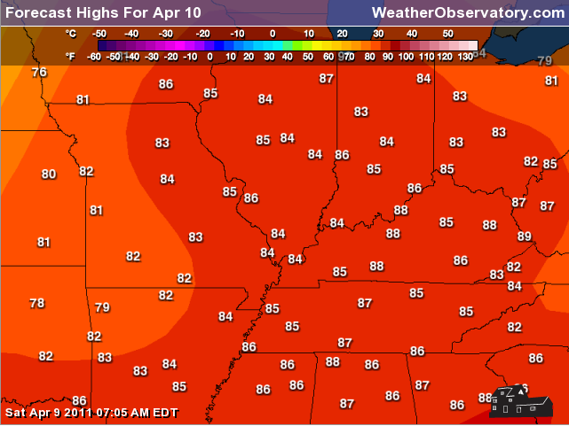
WARM - will be the rule. Temperatures tonight will only fall into the middle or upper 60s and highs both this afternoon and on Sunday will reach into the 80s.-
A cold front will bring a line of thunderstorms late Sunday night into our area. Right now it appears the line will move into our western counties of southeast Missouri between 9-11 pm and central counties including Marion, Metropolis, and Paducah between 1 am and 4 am. Then spreading east from there. -
Some strong winds will accompany the line of storms - hail can't be ruled out. The severe weather risk appears lower than a few days ago. However, we will need to monitor. I believe we will likely end up in a slight risk (from the Storm Prediction Center) for Sunday night and Monday morning.-
Next threat for storms will arrive on Thursday. Severe weather is once again possible.-
Couple of graphics showing today's high temperatures and tomorrow! ENJOY!-

-
-
Saturday, April 9, 2011.
Severe thunderstorm watch for portions of Indiana, Illinois, and Kentucky - the watch will be cancelled as the line of storms passes through each county.
.
The severe thunderstorm watch outline can be viewed here
http://www.spc.noaa.gov/products/watch/ww0111.html
.
Latest watches and warnings can also be viewed here
http://weather.weatherobservatory.com/maps/severe/warnings/all/uslowerohvalley.html
.
The rest of the day is supposed to be dry - can't rule out a few isolated showers and thunderstorms. But - mainly dry once the line passes through early this morning.
.
Warm with temperatures into the 80s today.
.
Expect strong winds on Sunday - gusting 30-40 mph on area lakes.
.
- Beau
Saturday, April 9, 2011
.
540 AM
.
Severe thunderstorms are moving through southeast and eastern Missouri. These storms will continue to push east into southern Illinois and western Kentucky. The heaviest storms could produce large hail and gusty winds.
.
Frequent lightning is also being observed with the thunderstorms.
.
Latest radar
http://www.weatherobservatory.com/weather-radar.htm
.
- Beau
Saturday, April 9, 2011
---
I will update the blog early on Saturday morning if we have strong or severe storms in the area. There is a chance the bulk of the storms stay up in Missouri and Illinois. We will just to monitor radar trends over the coming hours.---
This site is best viewed with Mozilla Firefox. There could be issues with spacing on Internet Explorer.
---
---
---
---

---
A few strong/severe storms are possible early Saturday morning. Gusty winds on area lakes.
---
----------------------------------
---
----------------------------------
---
A warm weekend is on tap for the region - gusty winds, as well - especially on Sunday. Expect temperatures to rise in the 80s both today and Sunday. Along with the warm air will come gusty southerly winds. Don't be surprised to see some 30 mph gusts on Sunday. ---
As of this writing (9 pm on Friday night) an area of strong to severe thunderstorms had formed over northern Oklahoma and southern Kansas. This area of thunderstorms is developing and moving east. I expect more thunderstorms to form over southwest Missouri over the coming hours. These storms will then push into southeast Missouri and southern Illinois after 2 am on Saturday.
---
There is still some question as to how far south the storms will extend. There is also some question as to how widespread the showers and thunderstorms will end up being. At this time I suspect that western Kentucky will also see a threat for thunderstorms on Saturday morning.
--
Any storms that do manage to hold together into our region will have the potential to produce heavy rain, strong winds, and hail. An isolated tornado can't be completely ruled out.
---
There is a bit of a CAP over the region and this should help prevent the storms from being surface based. This basically means the greatest threat from storms would be damaging wind and hail.
--
Otherwise - any storms that do form should move out of our area by late Saturday morning. This will leave the rest of Saturday dry.
--
Sunday will bring our next weather system. There is a lot of debate on the timing of this system. I believe the cold front will approach our western counties by 6-8 pm and spread into southern Illinois and western Kentucky between 11 pm and 4 am. Again - some debate on this.
--
The timing of the front is important as far as the severe weather threat goes. The earlier the front arrives the better the chance for severe thunderstorms. This will need to be monitored.
---
The National Weather Service, Storm Prediction Center, local media, and others will be closely monitoring the Sunday event. Check back often for updates over the coming days. I will keep the blog updated - most likely will update a few times each day - also check out the Facebook page.---
---

---
This forecast covers far southern Illinois, southeast Missouri, and western Kentucky---
Highs: middle 80s | Wind: South winds at 10-15 mph - gusts over 20 mph.
---
Saturday night: Partly cloudy and mild.
Lows: around 66 | Wind: South winds at 10-15 mph.
---
Sunday: Partly cloudy. Warm. Above normal temperatures.
Highs: around 85 degrees | Wind: South/southwest winds at 15-20 mph with gusts to 30 mph. ---
Sunday night: Showers and thunderstorms late. Some storms may be severe. Mild.
Lows: around 65 degrees | Wind: South winds at 10-15 mph with gusts over 20 mph. ---
Monday: A chance for thunderstorms early in the morning. Turning cooler. Windy.
Highs: early in the day - in the 70s then falling in the afternoon | Wind: South/southwest winds at 10-20 mph - gusting to 30 mph becoming west at 15-25 mph with gusts over 35 mph.---
---
Video has been posted and updated on the Weather Observatory web-site (simply click on the day of the week for the latest video).
---

The forecast for severe or extreme weather risk for today, tonight, and tomorrow: A chance for severe thunderstorms early on Saturday.
---
--
We have a number of new radars available on our Weather Observatory web-site!---
We now offer St Louis, Mt Vernon, Evansville, Poplar Bluff, Cape Girardeau, Marion, Paducah, Hopkinsville, and Dyersburg Interactive City Radars. We also have the two regional radars and now offer you three GR Earth radars.
http://www.weatherobservatory.com/weather-radar.htm---
---
--------------------
---

---
1. Severe weather is possible on Sunday night. Threat does not appear as great as earlier forecasts. However, there will be a chance for hail and damaging winds. Watch for updates as I get a better idea of how the squall line will unfold and the exact timing for our counties.
-
2. Another chance of rain will arrive on Thursday into Friday. It is too early to determine the track of that storm system or whether it will bring any threat of severe weather.
--
You can find me on Twitter under Beau Dodson You can find me on Facebook under Beau Dodson Weather - hit LIKE at the top of the page
---
Meteorologist Beau Dodson---
McCracken County Office of Emergency Management
---
----------------------
For the latest watches and warnings please visit your local National Weather Service Office
http://www.weather.gov/organization.php
---
To view all watches and warnings in Illinois- Click HereTo view all watches and warnings in Kentucky - Click Here
To view all watches and warnings in Missouri - Click Here
To view all watches and warnings in Tennessee - Click Here
---
To view all watches and warnings in Tennessee - Click Here
---
Other States- Click Here
---
This site is non-profit and brought to you as a public service.
No comments:
Post a Comment