2 PM
There will be a chance for a few severe thunderstorms over southeast Missouri and southern Illinois on Monday afternoon and Monday night. The main concern will be gusty winds and hail up to the size of quarters.
Officially the Storm Prediction Center has not outlined the area for severe storms - however, I believe there should be a slight risk outlined over parts of Missouri and Illinois - less sure about areas just south of that area.
Thunderstorms will form along a warm front that will be moving through the area.
- Beau
Sunday, April 17, 2011
Let's take a look at some new maps I put together on the outbreak - keep in mind most of these reports are from Thursday through Saturday. Incredible and historic outbreak.
.
The first graphic shows you are of the wind, tornado, and hail reports. Blue would be hail - orange would be wind - red would be the tornadoes. Then I separated them in the following three charts.
.


.
Sunday, April 17, 20119 AM Update
Severe weather outbreak possible Tuesday into Wednesday - likely centered on Tuesday evening into Tuesday night. All modes of severe weather will be possible in our counties. I am expecting the Storm Prediction Center (the agency that is in charge of severe weather outlooks) to place our region in a moderate risk for severe storms.
.
The most severe weather risk may extend from south central Missouri into portions of central and southern Illinois. We will need to monitor the track of the storm and the CAP. Remember that the CAP can keep thunderstorms from forming. We will have a CAP on Tuesday for most of the day. In order for this CAP to break we will need enough lift to get storms to form. I believe we will have enough lift at some point on Tuesday evening or Tuesday night. But question remain on timing and exact placement of the most significant risk for severe storms. Bottom line - stay tuned for updates.
.
Here is the latest probability map for Tuesday from SPC. Probabilities are for a severe weather event to occur with 25 miles of any given location. They already have placed a 30% risk zone around our area. This is considered quite high for that far out. You normally do not see probabilities that high - 3 days out..

.
Sunday, April 17, 2011
Our new forecast page is finished! Just click the link below to see all of our Weather Observatory graphics - from the severe weather outlook to lake and river stages - extended outlooks - monthly outlooks - satellite - and more!
Weather Observatory Graphics and Forecast Page
River stages - check out the major flooding across the northern Plains (you can click down to our local area)
http://weather.weatherobservatory.com/rivers/us.html
This site is best viewed with Mozilla Firefox. There could be issues with spacing on Internet Explorer.
---

---
No concerns today. Rivers continue to rise. Click here for lake and river stages.
---
----------------------------------
---
----------------------------------
---
Sunday will bring nice weather. Warmer temperatures and more sun. Enjoy! Highs will be near 70 degrees across most of our area. .
I am watching the Tuesday afternoon into Wednesday time frame for a possible severe weather outbreak over portions of Missouri, Illinois, Indiana, Kentucky, Arkansas, Oklahoma and areas south and east. This could be a big deal. Stay tuned.
---

---
This forecast covers far southern Illinois, southeast Missouri, and western Kentucky---
Sunday: Partly sunny. Warmer than Saturday!
Highs: in the lower 70s | Wind: winds from the south at 10-20 mph. ---
Sunday night: Partly cloudy. Milder than previous nights.
Lows: around 53 degrees | Wind: south winds at 5-10 mph. ---
Monday: Partly cloudy. A slight chance for a shower. Warmer.
Highs: in the middle 70s | Wind: south winds at 10-20 mph with gusts to 25 mph. ---
Monday night: Increasing clouds. A slight chance for showers and thunderstorms.
Lows: around 64 degrees | Wind: south winds at 10 mph. ---
Tuesday: A mixture sunny and cloudy. A chance for severe thunderstorms late in the day - more likely Tuesday night. Warmer and breezy.
Highs: around 80 degrees | Wind: south winds at 15-25 mph with gusts to 35 mph.---
Weather Observatory Home Page - Click Here
Below - High temperatures for Sunday afternoon
.
 .
.
Below - High temperatures for Monday afternoon
.

.
Below - High temperatures for Sunday afternoon
.
Below - High temperatures for Monday afternoon
.
.
--------------------
---
Video has been posted and updated on the Weather Observatory web-site (simply click on the day of the week for the latest video).
---

The forecast for severe or extreme weather risk for today, tonight, and tomorrow. No severe weather for Sunday or Monday. Watching Tuesday afternoon into Wednesday. Please pay attention to updates in the coming days.
.
Here is Tuesday map - broad brushed. You can see quite a bit of weather in our area. I don't know why that green showed up over us - that should be red for storms..

.
An incredible outbreak of tornadoes has struck the southern United States over the last three days. Preliminary tornado count has now topped 200. Keep in mind this is preliminary and some of these may be duplicate reports. However, even with that in mind - this was a huge event. Many many towns have damage across areas from Oklahoma into the southeast United States.
Here is a map - the red dots are tornadoes. Blue is wind and green is hail.
.

.
We have a number of new radars available on our Weather Observatory web-site!---
We now offer St Louis, Mt Vernon, Evansville, Poplar Bluff, Cape Girardeau, Marion, Paducah, Hopkinsville, and Dyersburg Interactive City Radars. We also have the two regional radars and now offer you three GR Earth radars.
http://www.weatherobservatory.com/weather-radar.htm---
---
--------------------
.
---

--
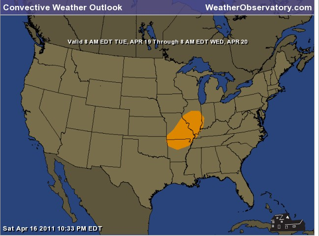
1. A significant outbreak of storms is possible Tuesday into Wednesday. This could be a big deal for portions of the region. Stay tuned as we fine tune the forecast over the coming days.
Here is the first outlook map - expect this area to be expanded - considerably.
.
2. I am watching the potential for another severe weather outbreak towards the end of the week. No break in sight.
--
You can find me on Twitter under Beau Dodson.
You can find me on Facebook under Beau Dodson Weather - hit LIKE at the top of the page
---
Meteorologist Beau Dodson---
McCracken County Office of Emergency Management
---
----------------------
For the latest watches and warnings please visit your local National Weather Service Office
http://www.weather.gov/organization.php
---
To view all watches and warnings in Illinois- Click Here.
To view all watches and warnings in Kentucky - Click Here
To view all watches and warnings in Missouri - Click Here
To view all watches and warnings in Tennessee - Click Here
---
To view all watches and warnings in Tennessee - Click Here
---
Other States- Click Here
---
This site is non-profit and brought to you as a public service.
No comments:
Post a Comment