5 PM Update
Long range looks wintry. January may be one to be remembered. The forecast for a cold December verified nicely - and late in December we abandoned the idea of January turning warmer.
Cold weather will likely be here for the next several weeks - we may flirt with the warm/cold boundary and several significant winter storms may ride along the boundary.
January 8, 2011
1 PM Update
Here are some new charts and don't forget we have the new precipitation type radar (bottom two radars on the radar page) for you to use now
Radar Page - http://weatherobservatory.com/weather-radar.htm
Explanation of new radar http://weatherobservatory.com/grearth_precip.htm
I believe some accumulating snow will be possible Sunday night into Monday afternoon along our southern tier of counties in Kentucky - it is a tough call based on the low dew points - however, believe at least an inch or two will be possible. Very difficult forecast - any shift in storm track will cause changes to the forecast. The Sunday night into Monday morning event is not a sure bet.
I will update this forecast between 5 and 6 pm this evening and several times later tonight and on Sunday.
Transportation Cabinet Forecast - for map of districts please click here
Saturday afternoon into Sunday
Snow showers continue over portions of central and eastern Kentucky. These will continue on and off. Light accumulations possible - especially in favored upslope areas.
---------------------------
Sunday night into Monday evening
Districts 1 - southern half of district 2 - all of 3 - southern half of district 4 - all of district 8, 10, 11, and 12
A chance for snow with 1-2" of accumulation possible. Locally higher amounts in snow belt and upslope areas of southeastern Kentucky.
Confidence is medium.
---------------------------
Monday evening into Tuesday evening
Districts 1, 2, 3, 8, 10, 11, 12
Snow developing. Additional Snow accumulation of 1-3". Locally higher amounts in snow belt and upslope areas of southeastern Kentucky.
Confidence is high.
---------------------------
Monday evening into Tuesday evening
Districts 4, 5, 6, 7, 9
Snow developing. Additional snow accumulation of 1-4".
Confidence is high.
---------------------------
Here are some probability maps from HPC - the first maps will be the chances for 1" or greater and the second maps will be the chances for 2" or greater - I don't see anything to disagree with in these charts

The above map is the probability of 1" or great of snow from Sunday night into Monday afternoon.

The above map is for Monday night into Tuesday evening - chances of 1" or greater of snowfall. Remember we are watching two systems.

The above map is the probability of 2" or greater of snow for Sunday night into Monday afternoon. You can see this southern system is going to come close to our area.
January 8, 2011:
10 AM Update
Well, good men disagree on the forecast for Sunday night and Monday for western and southern Kentucky. There are two solid camps.
Camp one is saying that snow will reach as far north as western and southern Kentucky on Sunday night and Monday morning. With some accumulation. As a matter of fact - the NWS Office out of Nashville has winter storm watches as far north as the KY border. Meanwhile - Kentucky has no watches in effect.
Then there is camp number two. Camp number two says that just about all of the moisture stays too far south on Sunday and Monday MORNING to cause any problems in Kentucky.
Now - I have said it a dozen times in my video updates and my blog. There are TWO storms we are dealing with. One on Sunday into Monday morning - the southern storm. Two being the system coming in from Montana and the northwest.
System two is the one I am forecasting 1-3 inches of snow for - this would be late Monday or Monday evening into Tuesday night.
System one - I have been saying will skirt the KY/TN border.
This is a tough forecast for our KY/TN border counties and perhaps as far north as 2 counties into Kentucky. ANY ANY ANY shift and we will see snow in Kentucky late Sunday night and Monday morning. Keep that in mind - it is not out of the question that light snow spreads as far north as the region in question. I will update accordingly. Either way the heaviest snow stays down south in AR/TN/MS/AL/GA.
As a matter of fact - it is THIS close :) - this is from the HPC which is forecasting the probability of 1" or greater of snow on Sunday night into Monday. Check out how close the southern storm system gets to Kentucky. The HPC has western and southern Kentucky in a pretty good shot at at least a dusting to an inch of snow. This will need to be closely monitored. Again, if you have travel plans south over the coming days then check road conditions.
Click image for a larger view.

I do see some shot at south-central Kentucky - which would be transportation districts 3, 8, and 11 (south-central and southeast Kentucky - perhaps a county or two in western-central Kentucky) getting a little bit of snow from the southern system. Less than 2 inches.
CLOSE CLOSE CLOSE call on system one - the southern system. There is still some time to tweak and update the forecast.
Now - system number two - the northern system - is still on track. I am forecasting a band of 3-5" of snow in portions of Missouri and Illinois - and 1-3" of snow for our region. Our region would be southern Illinois and western Kentucky.
Most of the guidance indicates that a portion of our region may miss most of both systems - that could mean a few rows of counties only end up with a dusting to an inch of snow. This will need to be fine tuned as we move forward.
Confidence is rising in a category 1 winter storm impact for Monday night into Tuesday night. Click here for category levels and impacts. My confidence level will remain at low (see link for confidence level information). I will upgrade that tonight as I become more confident in the event.
Again - this would be the lowest level on the category scale. A fairly common event - not considered major. Light snow accumulations. I made the scale system in order to give you a better idea of what to expect as far as impacts.
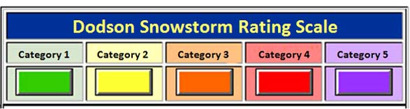
Category 1 Snowstorm
Accumulation: Snowfall accumulations of 1-4" are forecast. A fairly common event
Life Threat Level: Low threat to life if residents use care and caution when venturing out. Remember that any roadway that is slick can be dangerous. Nearly 1000 people were killed during the last two winters from accidents on slick roadways.
Travel Impact: Roads may become slick. Use caution.
Economic Impact: Little to low economic impact is expected.
Advice to Emergency Officials: Expect normal snow related operations. Listen for updates from the NWS and local media.
-----------------------------
Here is the morning NAM Model Snowfall Forecast. Not a lot of change - but thought you might be interested in seeing what it is spitting out.

Another storm will impact our region around next Friday into Saturday and then another threat early the following week.
Next update will be around 4-5 pm this evening.
Have a great Saturday
January 8, 2011
1 AM Update
I will update the forecast several times a day into the weekend - those with travel plans across the southern United States into the Tennessee Valley should stay abreast of latest watches and warnings.
I will add graphics later today, as well - so check back for several updates.
New video has been posted for January 8th - http://weatherobservatory.com/weather-video.htm
You can find more updates on my Facebook (under Beau Dodson) - Twitter, as well.
Bottom line it for me Beau...
For southern Illinois and far western Kentucky...
The forecast for severe or extreme weather risk for today, tonight, and tomorrow: 0%
The forecast for freezing rain, sleet, or snow today, tonight, and tomorrow: Light flurries possible.
Forecast:
Saturday - Partly Cloudy - a few flurries or snow showers scattered around. High temperature around 23 degrees.
Saturday Night - Partly Cloudy - stray flurry. Cold. Lows around 12 -15 degrees.
Sunday - Increasing clouds. A chance for snow late in the day across the far southern portions of our region (mainly Tennessee and Arkansas). Chilly. High temperatures near 30 degrees.
Sunday Night - A slight chance for snow - especially over the southern part of our region. Cold. Low temperatures in the middle 20s.
Monday - A slight chance for snow - mainly southern half of area. Cloudy otherwise. High temperature in the 30s.
We will be watching for snow chances on Monday night and Tuesday across our region. First call is for 1-3". Stay tuned as exact track is still a bit uncertain.
This would be a category one event on my snowstorm scale - for more information on the scale - click here.
Your up to the minute National Weather Service seven day forecast for southern Illinois and western Kentucky can be viewed by clicking here.
Your regional and local radars - including our new precipitation type radar - click here.
Barometer readings can be viewed here - Barometer Readings.
-----------------
You can view current conditions - weather radar and more information by clicking here
I will update the blog several times a day through the weekend.
Here is the latest NAM Model for Snowfall Forecast - you get the general idea (this is through Monday night) Click for larger view.

I am also concerned about a system for next weekend.
Stay tuned for updates...
If you would like to be added to the severe weather email list then please email me and request to be added - I usually send out an email during significant weather events. Email me at beaudodson@usawx.com
- Meteorologist Beau Dodson
McCracken County Office of Emergency Management
Please visit Chris Bailey's weather blog if you live in central and eastern Kentucky http://www.kyweathercenter.com/
For the latest watches and warnings please visit your local National Weather Service Office http://www.weather.gov/organization.php
To view all watches and warnings in Kentucky - Click here
To view all watches and warnings in Illinois - Click here
Other States - Click Here
This site is non-profit and brought to you as a public service.
No comments:
Post a Comment