Next update will be tonight's regular update (around 10 pm)
10 AM Snowfall Update: Here is a map I put together - you can get the general idea on how the snow is expected to develop and accumulate. Simply click the map for a larger view.
I don't and won't change snowfall totals with every run of every model - just not the way one is supposed to forecast. If you did that then you would be changing your forecast every few hours. Again - not the way to forecast.
I have tweaked my totals a little bit from the previous forecast 24 hours ago - but not much. An inch here or so - added some thoughts on banding and other.

I tweaked the numbers slightly - raised them in some counties and left them alone in other counties.
Generally speaking this will be a category 1 snowstorm - with the potential for a low end category two snowstorm over portions of southeast Missouri into southern Illinois and southern Indiana.
It will be nearly impossible to determine where the heavier bands of snow may form - briefly - during this event. There could be a stripe of locally heavier snow over portions of southeast Missouri and southern Illinois into southwest Indiana. This will be something that will need to be "nowcasted" - meaning that we probably won't be able to forecast that more than a few hours in advance.
There is a chance there could be a band set up over northeast AR into western TN and portions of southern Kentucky. Again - this will have to be nowcasted and won't be known until the event is underway. It would not surprise me to see some slightly higher totals over the above mentioned area - just need to wait and see.
Bottom line - a general 2-4" snowfall across much of the region. If someone picks up a bonus inch here or there then that would change your totals - but generally I think we are on top of this system.
Bitterly cold air temperatures and wind chill values on Thursday night into Saturday.
I can't list every city - pick the city closest to your location and draw it out - also see the above map.
Here are the new numbers for everyone.
ILLINOIS
Carbondale, IL 2-4
Cairo, IL 2-3"
DuQuoin, IL 3-4" locally 5" possible
Harrisburg, IL 2-4" Locally higher amounts possible near this area
Marion, IL 2-4 Locally higher amounts possible near this area
McLeansboro, IL 2-4" Could be a locally heavier band set up somewhere near there
Metropolis, IL 2-3"
Mt Vernon, IL 3-5"
Wayne City, IL 3-5"
Rosiclare, IL 2-3" Could be a locally heavier band set up somewhere near there
Olney, IL 3-4" Locally 5"
Sparta, IL 3-4"
Vienna, IL 2-3"
INDIANA
Evansville, IN 3-4" Locally heavier possible
Princeton, IN 3-4" Locally heavier possible
MISSOURI
Farmington, MO 3-5"
Advance, MO 2-4"
Dexter, MO 2-4
Kennett, MO 1-3"
Perryville, MO 3-4" Locally higher amounts possible
Maldon, MO 2-3"
Marble Hill, MO 2-4"
Piedmont, MO 3-4" Locally higher amounts possible
St Louis, MO 3-5" locally higher near that area
Cape Girardeau, MO 2-3"
Sikeston, MO 2-3"
KENTUCKY
Ashland, KY - 2-4"
Elizabethtown, KY 3-4"
Benton, KY 2-3"
Bowling Green, KY 2-3"
Cadiz, KY 2-3"
Cuba, KY 1-3"
Henderson, KY 2-4"
Hopkinsville, KY 2-3"
Leitchfield, KY 2-4"
London, KY 1-3"
Louisa, KY 2-4"
Louisville, KY 3-4" Locally higher amounts over far northern KY
Lexington, KY 1-3"
Mayfield, KY 1-3"
Morgantown, KY 1-3"
Murray, KY 1-3"
Madisonvile, KY 2-3"
Owensboro, KY 2-4"
Paducah, KY 2-3"
Somerset, KY 1-3"
Symsonia, KY 2-3"
Wickliffe, KY 2-3"
Williamstown, KY 3-5" Locally higher amounts possible
TENNESSEE
Dyersburg, TN 1-2"
Martin, TN 1-2"
Paris, TN 1-2"
Union City, TN - 1-2"
Northeast Arkansas - 1 to 3 inches possible. Will be watching for a possible band of heavier snow somewhere in north central Arkansas.
Winter Weather Radar is up and running
http://weatherobservatory.com/weather-radar.htm
Note - I have changed my Facebook to BEAU DODSON WEATHER
January 19, 2011
Previous discussion...
Next update will be at 10 AM
Most of this snow will fall late Wednesday night - northwest part of the region and then spread south and east on Thursday into Thursday evening. Snow should come to an end on Friday - cold into the weekend.
See the video for time line on snow...
ILLINOIS
Carbondale, IL 1-3"
Cairo, IL 1-3"
DuQuoin, IL 2-3" locally 4" possible
Harrisburg, IL 1-3"
Marion, IL 1-3"
McLeansboro, IL 1-3"
Metropolis, IL 1-3"
Mt Vernon, IL 2-4"
Wayne City, IL 2-4"
Rosiclare, IL 1-3"
Olney, IL 2-4"
Sparta, IL 2-4"
Vienna, IL 1-3"
INDIANA
Evansville, IN 2-4"
Princeton, IN 2-4"
MISSOURI
Farmington, MO 2-4"
Advance, MO 1-3"
Dexter, MO 1-2"
Kennett, MO 1-2"
Perryville, MO 2-4"
Maldon, MO 1-2"
Marble Hill, MO 1-3"
Piedmont, MO 1-3"
St Louis, MO 3-5" locally higher near that area
Cape Girardeau, MO 1-3"
Sikeston, MO 1-3"
KENTUCKY
Ashland, KY - 2-4"
Elizabethtown, KY 2-3"
Benton, KY 1-3"
Bowling Green, KY 1-3"
Cadiz, KY 1-3"
Hopkinsville, KY 1-3"
Leitchfield, KY 2-3"
London, KY 1-3"
Louisa, KY 2-4"
Louisville, KY 2-4"
Lexington, KY 1-3"
Mayfield, KY 1-2"
Morgantown, KY 1-3"
Murray, KY 1-2"
Madisonvile, KY 1-3"
Owensboro, KY 2-4"
Paducah, KY 1-3"
Somertset, KY 1-3"
Symsonia, KY 1-3"
Wickliffe, KY 1-3"
Williamstown, KY 2-4"
TENNESSEE
Dyersburg, TN 1-2"
Martin, TN 1-2"
Paris, TN 1-2"
Union City, TN - 1-2"
Winter Weather Radar is up and running
http://weatherobservatory.com/weather-radar.htm
Note - I have changed my Facebook to BEAU DODSON WEATHER
I am now doing video weather briefings
January 18th Video - http://weatherobservatory.com/weather-video.htm
You can find more updates on my Facebook (under Beau Dodson Weather) - Twitter is under Beau Dodson
Bottom line it for me Beau...
For southern Illinois and far western Kentucky...
The forecast for severe or extreme weather risk for today, tonight, and tomorrow: None
For southern Illinois and far western Kentucky...
The forecast for severe or extreme weather risk for today, tonight, and tomorrow: None
The forecast for freezing rain, sleet, or snow today, tonight, and tomorrow: Snow will fall over the entire region late tonight and especially on Thursday. Late tonight over the far northwest and northern portions of the area - then spreading south and east into far southern Illinois and western Kentucky during the morning hours on Thursday.
Forecast:
Wednesday - Some fog in the morning. A few patches of light freezing drizzle very early in the morning will be possible (before 4 am). Otherwise, Mostly cloudy and cold. Highs near 34 degrees.
Wednesday Night - Cloudy. Chance for snow very late over our northwest and northern counties. Low temperature around 24 degrees.
Thursday - Snow likely. Some accumulation possible. High temperatures around 32 degrees. Temperatures falling into the 20s during the afternoon.
Thursday night - Snow likely early. Windy and cold. Low temperature in the middle teens.
Friday - Flurries possible. Windy and cold. Highs in the lower 20s.
Your up to the minute National Weather Service seven day forecast for southern Illinois and western Kentucky can be viewed by clicking here.
Your regional and local radars - including our new precipitation type radar - click here.
Barometer readings can be viewed here - Barometer Readings.
-----------------
Barometer readings can be viewed here - Barometer Readings.
-----------------
Snowfall accumulations of 1-3" will likely occur across our entire region on Wednesday night and Thursday. Some heavier accumulations are possible. Heavier accumulations are most likely in area closer to St Louis and Mt Vernon (see snowfall forecast above - I will update that around 10-11 am this morning)
This would be a category 1 on the snowstorm scale. It is possible that portions of the region may be impacted by a category 2 winter storm (northern portions). Confidence is very high in this event.
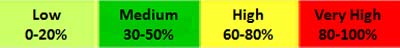
You can read more about the snowstorm rating scale by clicking here.
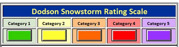
Dodson Snowstorm Rating System
Category 1 SnowstormAccumulation: Snowfall accumulations of 1-4" are forecast. A fairly common event.
Life Threat Level: Low threat to life if residents use care and caution when venturing out. Remember that any roadway that is slick can be dangerous. Nearly 1000 people were killed during the last two winters from accidents on slick roadways.
Travel Impact: Roads may become slick. Use caution.
Economic Impact: Little to low economic impact is expected.
Advice to Emergency Officials: Expect normal snow related operations. Listen for updates from the NWS and local media.
Meteorologist Beau Dodson
McCracken County Office of Emergency Management
Please visit Chris Bailey's weather blog if you live in central and eastern Kentucky http://www.kyweathercenter.com/
For the latest watches and warnings please visit your local National Weather Service Office http://www.weather.gov/organization.php
To view all watches and warnings in Kentucky - Click here
To view all watches and warnings in Illinois - Click here
Other States - Click Here
This site is non-profit and brought to you as a public service.
No comments:
Post a Comment