Snowstorm is behaving as expected.
Only part of the forecast that has not verified so far is the St Louis area. They had more snow than expected in some counties.
Otherwise - at 1 PM this afternoon I measured 3" here at my place.
Reports of 1-3" over western Kentucky. Will wait for final totals to see how things worked out.
Snow will continue for the next few hours. A band of heavier snow is pushing through west Kentucky and will drop a quick 1" in places.
Very cold temperatures tonight into Saturday - may see some single digits in the region.
- more updates later this afternoon
Beau
January 20. 2011:
Well, the snow event is upon us. Let's see what can go wrong with this forecast. It seems like snow events like to cause headaches for weather forecasters and I am sure this one will be no different.
We will see how it goes - here are my best thoughts for the snow event.
Latest snowfall forecast map - this will give you a general idea of how this system will unfold. Can't rule out some pockets of heavier snow scattered in the 1-3" region. If so then possibly a bonus inch for some counties - so instead of 1-3" it would be 2-4". But - generally speaking - this is how I see this unfolding.

Winter Weather Radar is up and running
http://weatherobservatory.com/weather-radar.htm
Note - I have changed my Facebook to BEAU DODSON WEATHER
I am now doing video weather briefings
January 18th Video - http://weatherobservatory.com/weather-video.htm
You can find more updates on my Facebook (under Beau Dodson Weather) - Twitter is under Beau Dodson
Bottom line it for me Beau...
For southern Illinois and far western Kentucky...
The forecast for severe or extreme weather risk for today, tonight, and tomorrow: None
For southern Illinois and far western Kentucky...
The forecast for severe or extreme weather risk for today, tonight, and tomorrow: None
The forecast for freezing rain, sleet, or snow today, tonight, and tomorrow: Snow today - snow will come to an end on Thursday afternoon and evening. Cold into Saturday.
Forecast:
Thursday - Snow likely. Widespread 1-3" snowfall - pockets of higher snowfall. High temperatures around 32 degrees. Temperatures falling into the 20s during the afternoon.
Thursday night - Flurries possible. Breezy and cold. Low temperature in the lower to middle teens.
Friday - Flurries possible. Cold. Highs in the lower 20s.
Friday Night - Flurries possible. Cold. Low temperatures in the middle teens.
Saturday - A chance for flurries. Cold. Highs in the 20s.
Sunday - Cloudy. Cold. Highs in the 30s.
Sunday night - Monday - A chance for snow or mixture of snow and rain.
Your up to the minute National Weather Service seven day forecast for southern Illinois and western Kentucky can be viewed by clicking here.
Your regional and local radars - including our new precipitation type radar - click here.
Barometer readings can be viewed here - Barometer Readings.
-----------------
Barometer readings can be viewed here - Barometer Readings.
-----------------
Snowfall accumulations of 1-3" will likely occur across our entire region on Thursday. Some heavier accumulations are possible. Heavier accumulations are most likely in area closer to St Louis and Mt Vernon.
This would be a category 1 on the snowstorm scale. It is possible that portions of the region may be impacted by a low end category 2 winter storm (northern portions). Confidence is very high in this event.
You can read more about the snowstorm rating scale by clicking here.
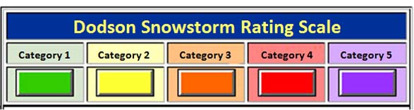
Dodson Snowstorm Rating System
Category 1 SnowstormAccumulation: Snowfall accumulations of 1-4" are forecast. A fairly common event.
Life Threat Level: Low threat to life if residents use care and caution when venturing out. Remember that any roadway that is slick can be dangerous. Nearly 1000 people were killed during the last two winters from accidents on slick roadways.
Travel Impact: Roads may become slick. Use caution.
Economic Impact: Little to low economic impact is expected.
Advice to Emergency Officials: Expect normal snow related operations. Listen for updates from the NWS and local media.
Meteorologist Beau Dodson
McCracken County Office of Emergency Management
--------------
Please visit Chris Bailey's weather blog if you live in central and eastern Kentucky http://www.kyweathercenter.com/
For the latest watches and warnings please visit your local National Weather Service Office http://www.weather.gov/organization.php
To view all watches and warnings in Kentucky - Click here
To view all watches and warnings in Illinois - Click here
Other States - Click Here
This site is non-profit and brought to you as a public service.
No comments:
Post a Comment