This site is non-profit and brought to you as a public service.
November 7, 2010:
Short post this morning :)
Beautiful day on tap for our region.
Your seven day forecast - click here. (I am not in agreement on the NWS forecast for precipitation on Thursday and Friday in our counties). I believe the system will likely be slower - more like Friday night into Sunday. Forecasters don't always agree - which is fine. :)
Fire danger is high today - please do not burn brush or debris. Fire departments are asking everyone to please work together to help reduce the threat.
Barometer readings today will be in the 30.30-30.40 range.
Check out the morning map - those are temperatures - 850 mb wind (see the air movement from southwest to northeast - that means milder air is heading into our region) - and water vapor satellite.
I am still leaning towards a risk for storms on Friday night into Sunday. Officially there are rain chances from Thursday into Friday. However, I am not sure the system will be that fast. Forecasts may need to be tweaked this week. The western portion of the region would have the better chance for rain late Thursday night and Friday. Then spreading eastward as we push into Friday night and Saturday.
Again - some disagreements on storm speed, storm track, and intensity. Severe weather can not be ruled out with this system. Depending on the track of the low there could be a squall line or thunderstorms associated with the front. Plenty of time to tweak this forecast.
The Storm Prediction Center remains fairly uninterested in this system - although they leave open the possibility to severe weather if the system does indeed develop further west. Moisture return is a concern - lack of instability, as well. However, if you remember the last big event - it was downplayed for awhile, as well (granted that was a much larger storm). Wind fields this time of the year are normally quite strong and it does not take a lot of moisture or instability to cause problems.
Stay tuned :)
Another storm system is possible early next week and then again towards the end of next week (the week of the15th)
Check out this map - this shows what one model is predicting for later in the month - blue areas are below normal temperatures. Brrr?
Also the official 8-14 day forecast shows below normal temperatures for a large section of the United States. Cold air is pooling in Alaska and Canada. We will see where it moves in the coming weeks. I am sticking with my call for November to end up below normal in the temperature department. This would be in contrast to the last few months when we have experienced nothing but above normal temperatures.
Chris Bailey has some more snow photographs from out east. For those interested - click here.
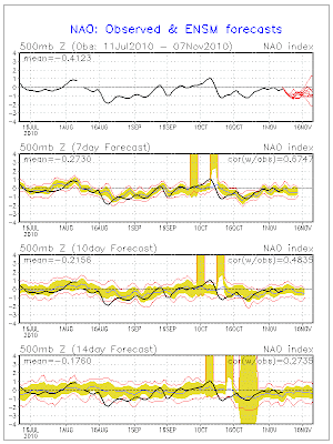
Also - check out the NAO - remember this is one index that I check on a regular basis - when the NAO is negative in the fall and winter then it normally means a trend towards cooler/colder weather in the east. You can see that it is in the negative territory. It is also forecast to stay negative.
That is your weather wrap for this morning - I am going to head out and enjoy the beautiful weather!!!!
Have a great day
- Meteorologist Beau Dodson
McCracken County Office of Emergency Management
For the latest watches and warnings please visit your local National Weather Service Office http://www.weather.gov/organization.php


No comments:
Post a Comment