November 4, 2010:
Don't forget that you can find me on Facebook and Twitter (under Beau Dodson). Add me for more frequent weather updates and information on weather events.
Bottom line it for me Beau...
Severe or extreme weather risk for today, tonight, and tomorrow: 0%
Elevated fire risk continues - dry conditions.
Partly sunny today with some breezy winds - occasional gust to 30 mph. Cool. High temperatures in the middle 50s.
A few clouds around tonight. A few early morning showers/sprinkles (the Paducah NWS even mentioned a flurry) across the eastern part of the area. Cool. Low temperatures in the middle 30s.
Some clouds on Friday - can not rule out a stray shower or sprinkle over the far eastern and northeastern part of our region. It will be rather cool. High temperatures from 48-50 degrees.
A region wide freeze is once again (many of us have already had a freeze) forecast for Friday night (meaning temperatures well below 32 degrees).
Barometer reading this morning is in the 29.85-29.92" range. Last 24 hours of data - click here.
-----------------------------------------------
Your seven day forecast - click here
Good morning everyone. A disturbance will move through the region tonight and tomorrow. This will cause gusty winds today into this afternoon. Winds in open areas and lakes will gust between 20 and 30 mph. Also a few clouds and sprinkles are possible later tonight and tomorrow morning across the far eastern portion of our area. Couldn't rule out a flurry if temperatures drop a bit more than expected. More of a novelty event than anything else.
Chilly temperatures for Friday night and Saturday night - lows should dip into the 20s to around 30. Brrrr. Otherwise a dry weekend is forecast with highs Saturday in the 50s and highs on Sunday near 60. A little on the cool side.
Here is the wind forecast map for later today - large area of gusty winds. This map is from www.wright-weather.com
You daily weather map from KPAH:
Here are a couple of more extended forecast maps. This first map is a long range model data map. This is the ensembles maps for a storm system approaching our region around the 13th of the month (give or take a day - too far off for certainties) - click for larger image.
Check out (above) the cold air advection map (cold air moving into our region)above forecast for Friday and Saturday. The blue colors are colder air moving in from the north. Then check this map out below. Just a few days later. You can see a quick return to more seasonal temperatures. The cold air on the first map is being drawn down behind a big storm system to our east. The low pressure wraps up in a counter-clockwise fashion. Thus pulling down cooler air from Canada.
By Sunday (above map) you can see the warm air advection! Warmer air moving in from the west. So, our cold spell will be transient in nature. Which is good news. Temperatures should moderate after the cold shot - starting as early as Sunday.
There are some indications of a weak front on Tuesday night into Wednesday night - could spark a few showers and storms. Then another system around 12th-15th. Perhaps a bit heavier. But - long way off. So we will just have to wait a bit longer to see how the storm develops and what its eventual path will be. I will keep en eye on it and update accordingly.
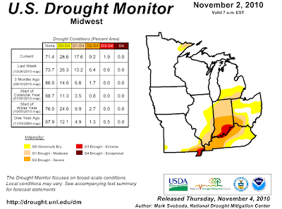
As you know our drought continues to grow worse. You can read more about the official drought numbers by clicking here. You can also click on that link for all of the state maps (I posted a few below).
The long range drought forecast - click here
Your November 4th Drought Maps: Click for large view.
I was going to touch a bit on the winter forecast - but I have not had time to put my thoughts together (other than what you see on the fall outlook link on the right side of the page - top). I can tell you that I do believe we will see an active storm pattern. That means numerous storm systems to monitor. Of course some of those storms will bring rain and others will bring snow and ice. We are used to this scenario across our region.
- Meteorologist Beau Dodson
McCracken County Office of Emergency Management
For the latest watches and warnings please visit your local National Weather Service Office http://www.weather.gov/organization.php


No comments:
Post a Comment