This site is non-profit and brought to you as a public service.
You can find more updates on my Facebook (under Beau Dodson) - Twitter, as well.
Bottom line it for me Beau...
For southern Illinois and far western Kentucky...
Severe or extreme weather risk for today, tonight, and tomorrow: 0%
Today - Quite a few low clouds around. Cool once again. High temperature only near 46-48 degrees. Northwest wind at 5 mph.
Tonight - Clearing late. Cool. Low temperature from 32 degrees. Some frost around - perhaps a little patchy fog, as well.
Friday - A few clouds. Warmer. High temperature from 58 degrees.
Weekend - Mix of sun and clouds. Dry. Mild. Small chance for showers Sunday evening and Sunday night. (might need to tweak that part of the forecast)
Your local seven day forecast can be viewed by clicking here.
Local and regional interactive radars can be viewed by clicking here.
Barometer readings today will range from around 30.15-30.40". Last 24 hours of data - click here.
-----------------------
Good morning everyone. Today is Thursday! That means just one more day until the weekend begins. I can already hear the shouts of joy. You will have a fine weekend on tap - get some shopping done for the holidays. The weather might not be as nice come next week and next weekend.
Don't forget that the Weather Observatory Holiday Open House is this Sunday - from noon to 5 pm. See the bottom of this page for directions and information. Look forward to showing everyone where the forecast is created.
We did pick up some rain overnight, as expected. I recorded 0.17". Not bad - add that to the previous rainfall and we are inching upward (no pun intended).
The drought continues. For the latest numbers - click here. The recent rainfall did help a little bit. But not nearly enough, of course.

The weekend should be dry - high temperatures in the 60s! Can't beat that in late November. There will be a few more clouds on Sunday. Models are trying their best to paint a little precipitation here and there over the region. However, I believe it will be mostly dry. If we need to tweak the forecast later then we can do that.
The Paducah, KY NWS posted this graphic. Click for larger view.

Let's take a look at a couple of maps from www.wright-weather.com - my choice for web-sites when it comes to model data.
First Saturday high temperatures and then Sunday :) Click for larger image - as always.

What about Sunday? How much above normal will we be on Sunday? Switching maps a bit. Let's take a look. Click for larger image - as always. Image is from www.wright-weather.com

A stronger cold front will approach on Monday/Tuesday. This front is going to spark our FOURTH chance of rain in the last 10 days. How about that! I promised a more active pattern as we headed into the middle and end of November. I am glad mother nature listened (for once).
Rainfall totals with the Monday/Tuesday system could be moderate in some spots. I would not rule out a thunderstorm or two. I am not sold on the severe weather idea - just yet. I think we need to keep an eye on the situation. Wind fields above us are fairly strong. That is one sign we look for when we start to think about severe weather. I will update the forecast accordingly. I know the NWS is on top of the situation - local media is hinting at the potential, as well. So - we are all in agreement that this is something we should at least keep an eye on.
Here are the expected weather maps on Monday into Wednesday. Several waves moving along the cold front will produce precipitation chances. The first map is for the 23rd and the second map is for Wednesday/Wednesday night. The purple area is rain - blue/green area would be heavier rain. Maps from www.wright-weather.com Click for larger view.


Big questions surround the Thanksgiving forecast into next Friday/Saturday. I have been promising you colder weather during that time period. So has Chris Bailey and several others. As a matter of fact a lot of local meteorologists have been saying this. So - we are fairly certain on it turning colder. What we are not as certain on is how we transition to the colder air.
The numerical model guidance all indicates that we will have a chance for rain towards the middle/end of next week. I would not be surprised to see some frozen precipitation in parts of the Ohio Valley into the northeast. Right now I am not overly excited about the event. The big story will be the cold (for now). That is where my confidence level is the highest.
I will need to tweak the forecast concerning the potential for rain or thunderstorms towards the middle/end of next week (Wednesday or Wednesday night) and then the potential for some frozen behind the front to our north and east. If the front can keep moving along then perhaps the stronger area of low pressure will be a bit east of us and best precipitation chances, as well. I am not overly confident - as you can tell - on how the holiday storm unfolds. As always - stay tuned :).
Otherwise - a cold wave is coming. Nothing unusual about that! It is late November and mother nature normally does send us a few shots of cold air during this time period. This could be the coldest air of the season so far. Not that that is saying much! Although we did dip down to 22 on two nights over the past month. So, it has been chilly on some mornings.
I like to show you departure maps for temperatures. Keep in mind this is the GFS. Which does okay in the short term - long range it isn't as great. However, these are the ensembles (same model runs - but tweaked a little bit differently - combined into one). These have a better rate of accuracy.
Let's take a look at how much above normal we are expected to be on Sunday. Basically the red areas on this map indicate a great chance of being above normal in the temperature department. The blue colors are cold. The second map will be next Saturday - the 27th. Notice any changes? I thought you would! Click for larger image - as always.


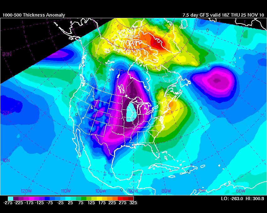
Here is a different look at the anomaly map. This is for Thanksgiving day. Those blue areas are cold! Well below normal temperatures over different heights of the atmosphere. There are some timing issues on when the cold air will arrive. Temperatures will likely be in the 60s ahead of the front. Then crash behind the front. Typical late fall cold front!
Let's take a look at that Wednesday night/Thanksgiving storm on the GFS ensembles. Each panel represents the same model but tweaked a little differently. A blend of these solutions would give us at least a chance for rain and possibly strong thunderstorms. Then colder air. I am not overly excited about this particular event as far as frozen precipitation in our area. Also in question is whether or not a second wave of low pressure moves up along the boundary will be key to the final forecast. Just something to watch - still a long ways off.
Bottom line for late next week - lots of time to keep an eye on this - but if you have travel plans during the holiday season then keep this in mind. The storm might slow you down a bit and could cause some airport delays in areas that receive snow - areas to our north and northeast. Again - I will tweak this forecast as we get a bit closer to the event. Click for larger image - as always.

The official NOAA 8-14 day outlook can be viewed here. This first image is the temperature outlook. As you can see the temperature forecast favors below normal temperatures during that time period. The second map is precipitation. You can see that odds favor above normal precipitation for our area.


If you follow the weather in the central and eastern part of Kentucky then please check out Chris Bailey's updates. Click here.
Did you know that it is winter weather preparedness week over our region? The Paducah, KY NWS wants to remind you of a few safety tips and how to better prepare for winter. Click here for more information.
Holiday Open House information:
We are having a Holiday Open House at the Weather Observatory and our home. Many of you have asked about seeing the new place on my family farm.
More information on the home can be found here:
http://weatherobservatory.
...We will be decorating for Christmas and inviting neighbors, friends, emergency management officials, and anyone else who would like to see the home and where I cover severe weather events for local emergency management officials.
My sisters and other family members will be here - we will also have refreshments and soft drinks.
Although the address is Belknap, Illinois - we are actually not in Belknap (that is how the post office divides this county). We are actually located about 7 miles north of Metropolis - near Round Knob, Illinois.
Most GPS systems have the house number or you can go to www.mapquest.com and put in our address. That will get you here, as well!
Easy directions:
From I24 - if you are coming FROM Paducah, Kentucky then simply get off the SECOND exit in Massac County (Exit 27). The exit sign will say New Columbia - Big Bay. Go to the stop sign at the end of the off-ramp and turn left. Go approximately 0.4 miles until you reach another stop sign. Turn left. Then go approximately 3.2 miles. You will turn right on Mermet Road (go 0.1 miles) - you will be able to see the house on the hill - red in color and a big Oak Tree - solar panels in the back. There will be a sign at the end of my driveway, as well.
If you are coming from Metropolis - go down North Avenue until you reach Round Knob. At the stop sign in Round Knob you will turn left. Go approximately 2 or 3 miles and turn left onto Mermet Road. I believe it is the first left that you can take that is a paved road. If you reach New Columbia then you have gone too far.
If you are coming from Marion, IL or Vienna, IL then just get off the first exit in Massac County - it will say New Columbia - Big Bay. Go to the stop sign at the end of the off-ramp. Turn right. Go to the next stop sign and turn left. Go approximately 3.2 miles. You will turn right on Mermet Road - you will be able to see the house on the hill (on the left) - red in color and a big Oak Tree - solar panels in the back. There will be a sign at the end of my driveway, as well.
My mailbox has 3954 on both sides of it. :)
If you have problems or need further directions then please email me at beaudodson@usawx.com
The Holiday Open House will be from noon until 5 pm on November 21st. This is a Sunday. The Sunday before Thanksgiving.
Hope to see you there!
We had a great day at Grand Rivers on Wednesday. The Paducah, KY National Weather Service Office put on a great winter weather workshop. The place was full! Weather radios were given away, great talks and presentations, we did the Turn Around - Don't Drown sign presentation from the Shadow Angel Foundation. Excellent workshop and we are making headway when it comes to safety and better preparing the local region for severe weather events!

What an amazing team of people we have in our region. We should be thankful - the Paducah NWS Office and all of the local media, transportation cabinet members, emergency management and spotters, and many many more.
- Meteorologist Beau Dodson
McCracken County Office of Emergency Management
For the latest watches and warnings please visit your local National Weather Service Office http://www.weather.gov/organization.php
No comments:
Post a Comment