5 PM Update
Should be a break this evening in the rain - then more rain will develop tomorrow morning and increase during the day. Locally heavy showers possible with a rumble of thunder.
- Beau
Friday, March 25, 2011
2 PM Update
No real changes in the overall forecast. Saturday is going to be wet - wet - wet. Cool, as well. Not the best day for outdoor activities. Wish I had better weather news for all of you.
The long range continues to point towards below normal temperatures with more rain around Tuesday or Wednesday.
Rainfall totals from now through Saturday night will likely be in the 1/2-1" range.
I would not be surprised to see the snow/rain mix line flirt with our counties on Saturday night. This will need to be monitored. Either way - cold and wet.
Beau
Friday, March 25, 2011
---
This site is best viewed with Mozilla Firefox. There could be issues with spacing on Internet Explorer.
---
No good news on the weather front - cold rain (even a mix of wintry precipitation for parts of our region) is heading our way. Rainfall totals over Friday and Saturday will range from 1/2-1" across the region. I would not be surprised to see some of our northern counties mix with or change to snow again on Saturday night. How far south that rain/snow makes it will need to be tweaked.
---
Otherwise - cold rain and below normal temperatures on both Friday and Saturday. Long range also indicates below normal temperatures. Our streak of above normal temperatures is over - for now.
---
Watching another significant system for next Tuesday. Will monitor.
---
---
---
http://www.weatherobservatory.com/weather-radar.htm
---
We will soon be offering you a lot more weather graphic products (see a sample below) - this should be ready in a week or two!Charities helping Japan...
---
---
---
---
http://www.charitynavigator.org/index.cfm?bay=content.view&cpid=1221
---
---
Bottom Line It For Me Beau... ---
---
Friday: Becoming cloudy with showers and a few thunderstorms likely - rain may be mixed with sleet and snow during the morning hours as far south as the KY/TN border. Cooler with below normal temperatures.
Highs: middle 40s | Wind: East/southeast winds at 10-15 mph.---
---
Friday night: Cloudy with a chance for showers. Below normal temperatures.
Lows: middle 30s degrees | Wind: Northeast winds at 10-15 mph. Gusty at times
Lows: middle 30s degrees | Wind: Northeast winds at 10-15 mph. Gusty at times
---
---
Saturday: Cloudy with scattered showers redeveloping during the morning hours - possible thunderstorm. Breezy and cool with below normal temperatures.
Highs: upper 40s and lower 50s | Wind: East/northeast winds at 10-15 mph with gusts to 20 mph.---
---
Saturday night: Cloudy with a cold rain likely - rain may be mixed with snow over some of our counties. Chilly.
Lows: around 34 degrees | Wind: North/northeast at 10-15 mph with gusts to 25 mph. Gusty winds at time.
Lows: around 34 degrees | Wind: North/northeast at 10-15 mph with gusts to 25 mph. Gusty winds at time.
---
---
Sunday: Precipitation ending early. A mix of sun and clouds. Cool with below normal temperatures.
Highs: middle 40s | Wind: North winds at 10-15 mph. Gusty at times.---
--------------------
---
---
You can find me on Twitter under Beau Dodson
---
---
You can find me on Facebook under Beau Dodson Weather - hit LIKE at the top of the page
---
---
---
Video has been posted and updated on the Weather Observatory web-site (simply click on the day of the week for the latest video).
---
---

---
---
---
---
The forecast for severe or extreme weather risk for today, tonight, and tomorrow: None.
---
---
Your regional and local radars - including several new interactive city radars - click here
---
-----------------------
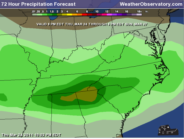
Let's take a look at where the precipitation will fall over the coming days - widespread precipitation is almost certain with this system. Now - it won't rain all the time - there will be some breaks. Precipitation should come to an end on Sunday morning.---
You can see the time tables on the maps and the precipitation type scale at the top of each image. Keep in mind that most of Sunday should be dry from mid-morning onward. ---

---
---
---

---
As far as rainfall amounts between now and Sunday morning - this map below will give you a general idea of what we are expecting.
---
---
One good thing about this pattern - I am not expecting an outbreak of severe thunderstorms in our region over the coming three day period. We will need to monitor next weeks storm track.
Meteorologist Beau Dodson McCracken County Office of Emergency Management ---
--------------------
---
For the latest watches and warnings please visit your local National Weather Service Office http://www.weather.gov/organization.php
For the latest watches and warnings please visit your local National Weather Service Office http://www.weather.gov/organization.php
To view all watches and warnings in Kentucky - Click here
To view all watches and warnings in Illinois - Click here
Other States - Click Here
This site is non-profit and brought to you as a public service.
No comments:
Post a Comment