---
---
Did someone say they would like to see some more warm weather? Well - you are in luck. Tuesday will bring more 70s to the region. With temperatures like this I am sure spring fever is spreading! ---
BUT - don't get tooooo used to the warm temperatures. Cooler air is already on the weather map and poised to move southward - this cooler air will arrive on Wednesday night and Thursday.
---
There will be a chance for a few thunderstorms along the front - not overly excited about the potential for severe weather in our immediate counties. I believe areas to our east will see a threat for strong/severe storms - especially over central and eastern Kentucky. Will monitor, as always.
---
Officially the Storm Prediction Center has outlined our region for severe weather - but I have to be honest with you when I say - I just don't see it. Perhaps further east of our immediate counties - a case could be made for a few strong/severe storms. But - it is a tough cell for me for southernn Illinois and southeast Missouri and western Kentucky. BUT - as always - needs situations should be monitored, And so - I will monitor for any changes, Updates on Tuesday. ---
I would not be surprised to see some of our counties experience a freeze next week. This is something I will need to monitor in the coming days.
---
Rivers will remain high for the next few weeks - although the Ohio River continues to slowly fall.---
--
We have a number of new radars available - please check them out! We now offer St Louis, Mt Vernon, Evansville, Poplar Bluff, Cape Girardeau, Marion, Paducah, Hopkinsville, and Dyersburg Interactive City Radars. We also have the two regional radars and now offer your three GR Earth radars.
http://www.weatherobservatory.com/weather-radar.htm
---
We will soon be offering you a lot more weather graphic products (see a sample below) - this should be ready in a week or two! ---
This site is best viewed with Mozilla Firefox. There are issues with spacing on Internet Explorer.---
Charities helping Japan...
---
---
---
http://www.charitynavigator.org/index.cfm?bay=content.view&cpid=1221---
---
Bottom Line It For Me Beau... ---
---
Tuesday: A mix of sun and clouds. Much above normal temperatures, once again.
Highs: from 76-79 | Wind: South/southwest at 10-15 mph with gusts to 25 mph.
---
---
Tuesday night: Becoming mostly cloudy. A slight chance for an overnight shower or thunderstorm - especially our western/northwestern counties. Mild. |
Lows: around 58 degrees | Wind: South winds 10-15 mph.
Lows: around 58 degrees | Wind: South winds 10-15 mph.
---
---
Wednesday: A mix of sun and clouds. A few thunderstorms - especially over our eastern counties - say from the Evansville area down to Kentucky Lake. If storms do form then some strong storms are not out of the question. Otherwise the rest of the region will be breezy with an isolated storm possible. Warm.
Highs: middle 70s | Wind: Southwest winds at 15-25 mph with gusts to35 mph.---
---
Wednesday night: Clearing and cooler.
Lows: around 40 degrees | Wind: Northwest winds at 10-15 mph.
Lows: around 40 degrees | Wind: Northwest winds at 10-15 mph.
---
---
Thursday: A mix of sun and clouds. Breezy and cooler.
Highs: lower 50s | Wind: North/northwest winds at 10-15 mph with gusts to 20 mph.---
--------------------
---
---
You can find me on Twitter under Beau Dodson
---
---
---
You can find me on Facebook under Beau Dodson Weather - hit LIKE at the top of the page
---
---
---
Video has been posted and updated on the Weather Observatory web-site (simply click on the day of the week for the latest video).

---
---
---
---
The forecast for severe or extreme weather risk for today, tonight, and tomorrow: Severe weather is not anticipated at this time.---
Your regional and local radars - including our new precipitation type radar - click here
---
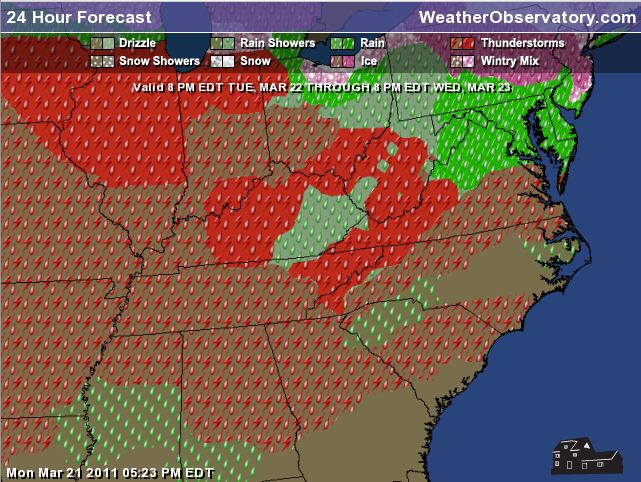
There will be some storms scattered around on Wednesday - you can see those storms here on this map - the red scattered dots means just that - scattered. The solid red areas are where more widespread storms are expected. The scattered weaker red area is probably quite a bit overdone. But - you get the general idea. The more widespread storm activity is forecast to our north and east.
---
---
---
---------------------------------------------
---
---
River stages continue to fall - at least over portions of the area. As you move closer towards Cairo the rivers remain in major flood stage. Here is the hydrograph from Paducah, Kentucky. We can think our friends over at the National Weather Service for their river and lake forecast stages.
---

River stages continue to fall - at least over portions of the area. As you move closer towards Cairo the rivers remain in major flood stage. Here is the hydrograph from Paducah, Kentucky. We can think our friends over at the National Weather Service for their river and lake forecast stages.
---
---


Meteorologist Beau Dodson
McCracken County Office of Emergency Management---
---
As you can see in the above image - the river is slowly falling. The river height can be found on the side bar with the dates from left to right as to the day of that river height.---
Let's take a quick look at the temperatures for the next few days - these maps are going to show you the high temperatures. You can see that the weather will turn cooler on Thursday. But - not before some warmers days on Tuesday and Wednesday. Not too bad.---
---
---
---
---
---
---
Meteorologist Beau Dodson
---
--------------
---
For the latest watches and warnings please visit your local National Weather Service Office http://www.weather.gov/organization.php
For the latest watches and warnings please visit your local National Weather Service Office http://www.weather.gov/organization.php
To view all watches and warnings in Kentucky - Click here
To view all watches and warnings in Illinois - Click here
Other States - Click Here
This site is non-profit and brought to you as a public service.
No comments:
Post a Comment