---
Say HELLO to Mr. Spring!!!!! ---
Warmer air arrives today - not that Saturday was cold - but today will bring 70s back into the region. I don't think we can complain about 70s in March. Now - just because it is spring doesn't mean winter is over. Well - okay - winter is over. HOWEVER, winter like weather may not be over. I would not be surprised to see some cold shots well into spring. Whether that spells additional snow threats - stay tuned. ---
A stray thunderstorm is possible on Sunday afternoon over the region - if a storm does form then it could be strong (isolated severe). These storms are not forecast to be widespread - but rather isolated. If they develop at all. ---
I am watching a system for the middle of the week - then a stronger system towards next weekend. Can't rule out some strong or severe storms with those two systems. The system next weekend may have a bit more instability to work with.---
The Storm Prediction Center has outlined a risk area for portions of our region on Tuesday/Wednesday. I will keep an eye on the system and update accordingly. This seems to be a low risk threat - at this time (at least for our immediate local counties). ---
The better chance of severe weather on Tuesday/Wednesday may end up being just to our west and then again just to our east. Timing is everything with severe weather - so if the system speeds up a bit or slows down then I will have to adjust my thinking.---
Rivers will remain high for the next few weeks - although the Ohio River continues to slowly fall.---
Stay tuned for updates.
---
---
We have a number of new radars available - please check them out! We now offer St Louis, Mt Vernon, Evansville, Poplar Bluff, Cape Girardeau, Marion, Paducah, Hopkinsville, and Dyersburg Interactive City Radars. We also have the two regional radars and now offer your three GR Earth radars. http://www.weatherobservatory.com/weather-radar.htm
---
---We will soon be offering you a lot more weather graphic products (see a sample below) - this should be ready in a week or two!
---
This site is best viewed with Mozilla Firefox. There are issues with spacing on Internet Explorer.---
Area residents should remember not to cross flooded roadways.
---
---
Charities helping Japan...
---
---
---
http://www.charitynavigator.org/index.cfm?bay=content.view&cpid=1221---
---
Bottom Line It For Me Beau... ---
---
Sunday: A mix of sun and clouds. Slight chance for an isolated thunderstorm. Warm.
Highs: 76-80| Wind: Southeast/south at 10-15 mph with gusts to 20-25 mph.
Highs: 76-80| Wind: Southeast/south at 10-15 mph with gusts to 20-25 mph.
---
---
Sunday night: Clouds. Mild. |
Lows: Lows around 55-58 degrees | Wind: South winds 10 mph.
Lows: Lows around 55-58 degrees | Wind: South winds 10 mph.
---
---
Monday: A mix of sun and clouds. Warm.
Highs: Highs in the middle to upper 70s | Wind: South winds at 10-20 mph with gusts to 25-30 mph.---
---
Monday night: Mostly cloudy.
Lows: Lows around 55-58 degrees | Wind: South winds at 10 mph.
Lows: Lows around 55-58 degrees | Wind: South winds at 10 mph.
---
---
Tuesday: More clouds than sun. A stray shower late in the date. Warm
Highs: Highs in the lower to middle 70s | Wind: South/southwest winds at 10-15 mph with gusts to 30 mph.---
--------------------
---
---
You can find me on Twitter under Beau Dodson
---
---
---
---
Video has been posted and updated on the Weather Observatory web-site (simply click on the day of the week for the latest video).

---
---
---
---
The forecast for severe or extreme weather risk for today, tonight, and tomorrow: Severe weather is not anticipated at this time.---
Your regional and local radars - including our new precipitation type radar - click here
---------------------------------------------
---
The bright colors are cloud tops. The red and white areas are tall/cold cloud tops. Quite the complex of storms and rain. Most of the deep red area is located over Missouri - I also included temperatures at the time of the image grab. This was taken around 9 pm Saturday evening.

Warm! Cooler air will filter in behind the cold front on Tuesday night and Wednesday.

---
---
---


---

McCracken County Office of Emergency Management---------------------------------------------
---
There was a rather large area of showers and thunderstorm over Missouri on Saturday night. I did grab this satellite image of the large complex of storms as it moved east/northeast through the state. There were quite a few warnings earlier in the day - mainly for hail. This is a rather large image - so I will reduce the size and you can click on it to view the large size.---
The bright colors are cloud tops. The red and white areas are tall/cold cloud tops. Quite the complex of storms and rain. Most of the deep red area is located over Missouri - I also included temperatures at the time of the image grab. This was taken around 9 pm Saturday evening.
---

---
Let's take a look at temperatures over the coming three day period. The first graphic is for Sunday and the following graphics will be for Monday and Tuesday.Warm! Cooler air will filter in behind the cold front on Tuesday night and Wednesday.
---
---
---
---
---
---
---
---
---
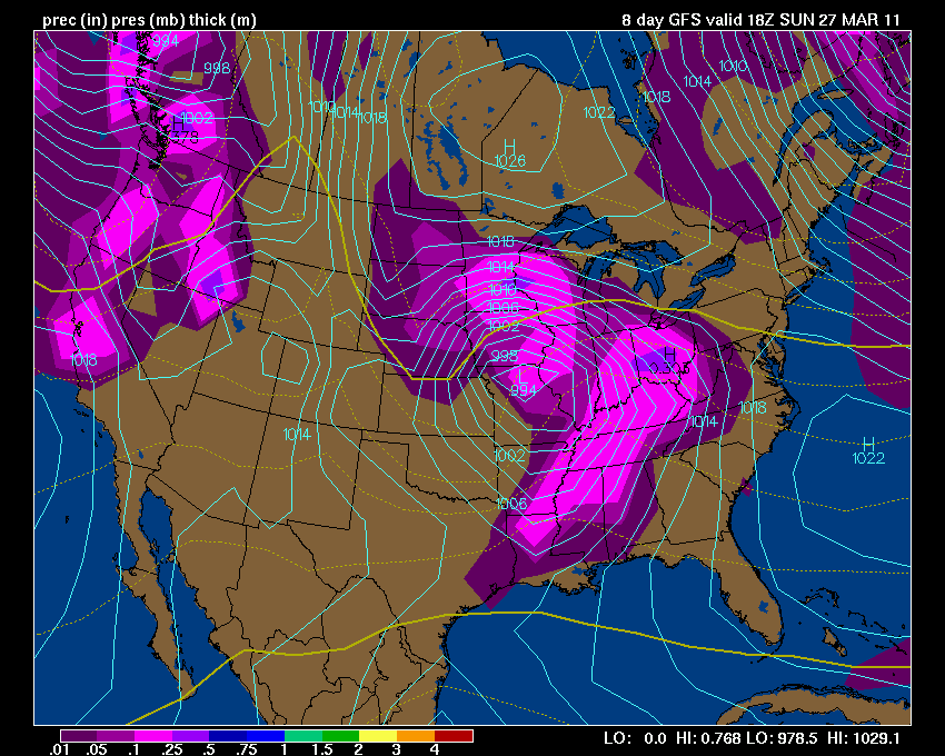
Here is a glimpse of the big storm for next weekend - again, long way off - but worth watching. This could produce some severe weather in the central United States. Click on the image for the full size. You can see the area of low pressure over Missouri. Remember that the pink and purple areas are precipitation (showers and thunderstorms).
---
---
---
---
Meteorologist Beau Dodson ---
--------------
---
For the latest watches and warnings please visit your local National Weather Service Office http://www.weather.gov/organization.php
For the latest watches and warnings please visit your local National Weather Service Office http://www.weather.gov/organization.php
To view all watches and warnings in Kentucky - Click here
To view all watches and warnings in Illinois - Click here
Other States - Click Here
This site is non-profit and brought to you as a public service.
No comments:
Post a Comment