March 3, 2011
Blog viewed best in Mozilla Firefox
Your 5 day rainfall forecast - WET
Click image for correct size view
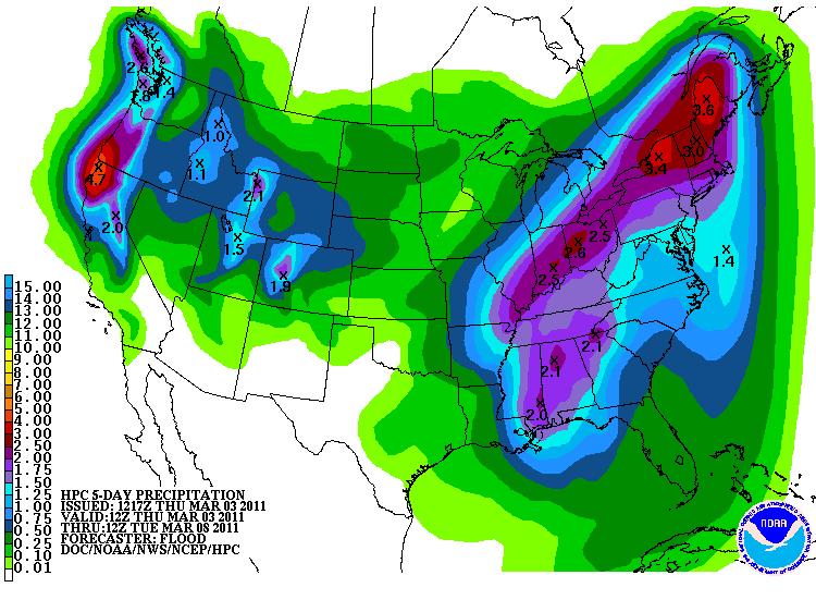
Area residents should remember not to cross flooded roadways. More rain is heading in our direction. Totals of 1-3" - widespread across the region on Friday and Saturday.
Thursday: Mostly sunny - few clouds around at times.
Highs: Highs in the upper 50s | Wind: Southeast winds at 5 mph.
Thursday night: Mostly clear and cool.
Lows: lower to middle 50s | Wind: Southeast winds at 5 mph.
Friday: Rain likely with thunder. Rain becoming heavier later in the days.
Highs: Highs in the lower 60s | Wind: Southeast winds at 10-15.
Friday night: Rain likely with thunder. Rain may produce heavy totals.
Highs: Highs in the lower 50s | Wind: Southeast winds at 10.
Saturday: Rain likely with thunder. Rain will not be as widespread late in the day. Some heavy rain possible..
Highs: Highs in the lower 50s | Wind: South winds at 10-15 mph becoming southwest at 15.
This blog is best viewed with Mozilla Firefox
You can find me on Twitter under Beau Dodson
You can find me on Facebook under Beau Dodson Weather - hit LIKE at the top of the page
You can find me on Facebook under Beau Dodson Weather - hit LIKE at the top of the page
Video has been posted and updated on the Weather Observatory web-site.
Bottom line it for me Beau...
For southern Illinois and far western Kentucky...

The forecast for severe or extreme weather risk for today, tonight, and tomorrow: Chance for a few strong storms on Friday/Friday night.
For southern Illinois and far western Kentucky...
The forecast for severe or extreme weather risk for today, tonight, and tomorrow: Chance for a few strong storms on Friday/Friday night.
Your up to the minute National Weather Service seven day forecast (note this may differ from my forecast from time to time) for southern Illinois and western Kentucky can be viewed by clicking here.
Your regional and local radars - including our new precipitation type radar - click here
----------------------------------------------
Active pattern is underway. Another storm system will roll into the region on Friday and Saturday - this system will spread additional showers and thunderstorms back into our local counties.
Rainfall totals of 1-2 are likely - pockets of 3-4" not out of the question.
Rainfall totals of 1-2 are likely - pockets of 3-4" not out of the question.
Flood or flash flood watches may need to be issued.
Another rain event for next Tuesday and Wednesday and then another one the following weekend. We are in a wet pattern.
Anyone have a boat?
Another rain event for next Tuesday and Wednesday and then another one the following weekend. We are in a wet pattern.
Anyone have a boat?
Stay tuned for updates...
Meteorologist Beau Dodson
McCracken County Office of Emergency Management--------------
For the latest watches and warnings please visit your local National Weather Service Office http://www.weather.gov/organization.php
To view all watches and warnings in Kentucky - Click here
To view all watches and warnings in Illinois - Click here
Other States - Click Here
This site is non-profit and brought to you as a public service.
No comments:
Post a Comment