October 25, 2010
5 PM - No changes in forecast. Line of storms expected by morning. If it is a solid line or a broken line is a bit uncertain. This will come down to a nowcast tomorrow morning - I will be up at 3 am covering it for local OEM.
One model run from this evening - shows maximum reflectivity - what radar might look like (composite).
An outbreak of severe thunderstorms is expected over a large area from the Great Lakes down to the Gulf of Mexico - including all of our region. Near record low pressure is expected with this storm over the Great Lakes.
As we have been talking about for days now - a squall line is expected to form late tonight and Tuesday morning across Iowa, Illinois, and Missouri. It will then stretch down into Arkansas.
I am expecting damaging winds and possible tornadoes with this line of storms. The area under the threat for severe weather has expanded to include even a larger area. See the SPC (Storm Prediction Center) link below.
The most severe damage could be in portions of IL/IN/OH/MI. To our north/northeast - about the same thoughts as I have been having. However, all of our area is in a risk.
The storms will be moving at speeds of 60-80 mph. Extremely fast movement. Any cells that can form ahead of the squall line could produce tornadoes. The biggest threat appears to be damaging winds.
Listen to local media and NOAA Weather Radios for updates on this developing storm system.
Wind advisories are likely later tonight and tomorrow for most of our counties.
I will update the blog through today and tonight.
The Storm Prediction Center Outlooks can be viewed here - click here.
The below map is the 500 mb wind field map - impressive negative tilt. These are winds ALOFT not at the surface. But - it gives you a good idea of how strong the jet streams are going to be. Winds at the surface in our area tomorrow (outside of thunderstorm winds) should be in the 25-40 mph range. Winds could be higher with the actual squall line - much higher in some areas.
One local NWS Office runs their own WRF model - this is what it is showing tomorrow morning - you can see the squall line form in MO and then push eastward. Click for larger view.
Here is another view from the St Louis, MO NWS WRF MODEL
One more - the updated WRF from SPC is out - it shows a solid line that breaks up into supercells then back to solid line - something we will have to carefully monitor. This is what the model is forecasting the radar to look like tomorrow morning. First image earlier and the last image later in the morning.
The map above is the latest from the SPC - showing where the most severe weather is expected to occur.
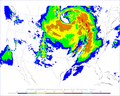
The above map shows wind gust potential (in knots) for tomorrow - another one below - click for larger images.
- Meteorologist Beau Dodson
McCracken County Office of Emergency Management
For the latest watches and warnings please visit your local National Weather Service Office http://www.weather.gov/organization.php


No comments:
Post a Comment