October 7, 2010:
Dry - but things should start to pick up around or after the 17th/18th of this month.
Today's weather map: High pressure continues to dominate our region. Click image for large view.
If you are looking for relief from the drought then you are going to have to wait a bit longer. No significant or widespread rain is forecast for the near term. There are some small rain chances for the Ohio Valley on Sunday night into Monday night. But - it does not appear to be significant - if we receive anything at all.
Your seven day official NWS forecast can be viewed by clicking here. Then go to the weather tab at the top and hit forecast. The Paducah, Kentucky NWS office has issued a drought statement - click here.
I am still watching a storm system for the middle of the month - around the 18th-24th. Pushed it back a few days. Let's hope we see verification for that system. Our region desperately needs rain.
Fire departments are asking people to not burn brush or grass. There have been several field and grass fires over the last few days.
Pasture conditions are poor to very poor over a large area of the region. Click the map below to take a closer look at pasture and range land conditions.
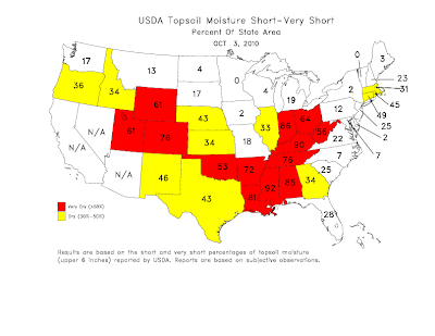
Much of Kentucky is considered very dry on the short temp topsoil moisture map (below).
Here (below) are the latest maps from Drought Monitor. Click the images to bring up the real size for better viewing. This first map is the Palmer Drought Index - it shows our region in a long term drought (which we already knew). Notice areas to our west and north have been extremely wet over the past six months. Once again it is the feast or famine pattern we have been in for some time now.
The above map is from Drought Monitor. This maps indicates that the drought has spread over a wider area - now covering much of the Ohio Valley and southern United States. The drought has expanded significantly over the past 2 months. Click the above map for a larger image.
The above map is zoomed in on our region. Notice that portions of our region are in severe drought conditions.
Let's take a look at the 60 day percent of normal precipitation map for the Ohio Valley (this doesn't capture the western half of our region - but you get the idea). Everything in brown is well below normal precipitation. This shows our drought conditions quite nicely. Again click the image to view the real size.
Below you can view the month to date (past six days) of precipitation in the United States. The red means little or no rainfall. Lot of red on that map! Click image for larger view.
We are now entering our windy season - fall and spring are normally our windiest time periods. Winter can be, as well. Stronger winds combined with low humidities will cause fire conditions to worsen.
We also have some more updated information - the NWS has updated their drought forecast maps. You can view those maps by clicking here.
Here is the latest map from the seasonal drought forecast. Note that our area is forecast to have persistent drought or for the drought to intensify. Again click the image for a larger view of the official forecast.
The overall pattern for the next two weeks will be for temperatures to average out near normal - I see several days of below normal temperatures and several days (the upcoming 4-5 day period) of above normal temperatures. Overall - a typical fall pattern. Dry weather is forecast to persist. Some showers are possible during the Sunday night into Tuesday morning time frame (does not look to be significant - if we receive anything at all) and another chance around the 18th-24th time frame.
I do expect November to see an increase in storms (which is normal) and I still believe we will see above normal precipitation from the December through March time frame (lot of forecasters seem to agree on this subject - especially as the La Nina weakens as we move further into winter/spring). See my previous forecasts and my fall/winter forecast thoughts.
The wild card in the forecast continues to be tropical activity. As most of you remember Tropical Storm Hermine brought much needed rainfall to portions of our area in early September. If we can pull another system into the Gulf of Mexico then our chances for rain would increase. However, at this time there is nothing to indicate that is going to happen in the short range. I will continue to monitor the Caribbean for development. It has been an active tropical season - but most of the tropical storms and hurricanes have stayed out to sea. Thus saving the United States from major impacts.
The Paducah, Kentucky NWS has issued a drought statement - click here.
Meteorologist Beau Dodson
McCracken County Office of Emergency Management
Proudly service southern Illinois and the State of Kentucky!
For the latest watches and warnings please visit your local National Weather Service Office http://www.weather.gov/organization.php


No comments:
Post a Comment