I may have to issue a beautiful weather warning for today and tomorrow. :) Fallish temperatures - sunny sky - light winds! A+ in my weather book!
No significant or widespread severe weather is expected through the next 5 days. A chance for showers will return on Tuesday. Today and tomorrow will be dry. However, I am still forecasting a shift in the pattern as we move towards the end of the month. Time to freshen up those weather radio batteries.
A roller coaster of sorts when it comes to temperatures for the next 15 days. Cooler then warmer then cooler then warmer - don't see any signals for persistent cold. Earlier this week it appeared much of the end of the month might close out cold. Latest data indicates that may not be the case - more of an up and down pattern when it comes to temperatures. Again - nothing unusual for this time of the year. It is fall after all!
I also am not seeing any strong signals for fall severe weather outbreaks. Yet. There are hints at a pattern change as we move towards the end of the month. This could introduce a better chance for strong storms - but still too far out to make a call. It has been an extremely quiet year for severe weather in most of our counties.
Your morning weather map: Click image for larger view.

Your seven day forecast can be viewed by clicking here.
Below is the way the weather map is expected to look on Tuesday. This is when our best shot of rain will arrive in the region. Scattered and once again not everyone will receive rain.

The official 8-14 day precip indicates that odds favor below normal precipitation. I do, however, think we may see a more active storm track towards the end of the month. So - stay tuned!

How about some snow? Portions of the northeast United States received snowfall on Friday into Friday night. A deep wound up area of low pressure (see previous post) was the culprit that helped produce the snow. I am sure there are a few snow fans that are enjoying the early preview to winter.
Here is a photograph from Killington Ski Resort in Vermont (Mountain). More on this story - click here.

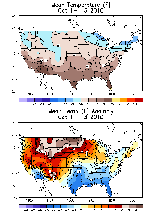
Let's take a look at the first thirteen days of October - temperatures. You can see we have had a lot of below normal days - although the latest data pushes us closer to normal when you add in the last few days. Officially the National Weather Service Office in Paducah, Kentucky is reporting that they are -0.1 degrees below normal. But - you get the general idea from these two maps. The top map is the mean temperature so far this month and the second map (below the top one) shows the departures from normal. Near normal over our area - to below normal across areas to our south. A large area of above to much above normal temperatures to our north. So far this month - that is how it shapes up.

Some new maps have been issued concerning the upcoming winter months (the one above and the one below). I don't see a lot of change from previous forecasts. This map (from this site) is indicating above normal precipitation (the area in blue) across portions of the Ohio and Midwest. Odds favor below normal precipitation over a large section of the southern United States. Also note the wet areas across the northwest part of the United States. This is what one set of model data indicates. It has been extremely consistent in this forecast.
Let's take a look at temperature forecasts - no change. Still pointing to above normal temperatures for December through February. Now I don't have any doubt we will see some significant cold waves this winter. These maps just indicate that the pattern will favor above normal temperatures compared to below normal. We may very well have an early start to winter and then see things level off. Meaning that December could start out chilly and then January and February could bring above normal temperatures.
Here is the latest map. Note the LARGE area of red - that indicates above normal temperatures. At least probabilities indicate above normal temperatures. The data is still pushing for a cold winter in Alaska and portions of northern and western Canada.

The below maps are from the GFS from www.wright-weather.com - Remember the GFS is a model. It predicts what it believes the future weather map will look like. The further out in time the greater chance of errors. But - I just wanted to show you some of the deeper storms that have been showing up in the long range. We will have to wait and see how it plays out. You can click on the images to enlarge.

This coming Tuesday (the above map) - a cold front approaches our area. Some showers expected along the front. Nothing extreme is expected or in the forecast.

Let's look all the way out towards the end of the month - this is what the GFS is showing for the 26th (above map). A nice system in the central United States. Could bring some threat of showers and storms to our area.

Finally - HALLOWEEN! A big storm in the central United States - wound up tight? This would bring gusty winds and some threat for thunderstorms. BUT - that is a long way off in weather land. Models don't do well that far off. But, something I will be keeping an eye on. The overall signal is for a bit more active weather as we move further into the month of October.
One last set of maps - from www.wright-weather.com
We will have to keep an eye on these systems - this map shows the 850 mb winds for the system around the 25-31st of the month. This would spell trouble if it is accurate (possible severe weather threat).


The above map is the forecasted dew points. Again - long way off.
The above maps are all from the GFS Model - one models opinion.
The GFS ensembles are also hinting at some significant systems as we head towards the end of the month. Could this finally be the break in the dry weather that we have been waiting for? Stay tuned!
Ensemble maps below (remember ensembles are the same model but run in a slightly different manner - to see if it comes up with a similar solution): Click for larger view

October 27th - GFS Ensembles (above)

October 30th Storm - GFS Ensembles (above)
But, for now - we have beautiful weather. And that is the weather you should enjoy! :)
- Meteorologist Beau Dodson
McCracken County Office of Emergency Management
For the latest watches and warnings please visit your local National Weather Service Office http://www.weather.gov/organization.php
No comments:
Post a Comment