Happy Halloween Weekend!!!!
Well, we thought it would be a nice weekend a week or so ago and it appears that forecast is on track! Thankfully, because there are a ton of outdoor activities tonight and tomorrow night. I will be attending the Zombie Walk in downtown Paducah! Looking forward to the fun.
I had thought we were moving towards a much more active pattern - I was wrong about that. That was becoming more and more obvious over the last few days. The models have a difficult time during the transition of seasons. I should have kept the "uncertainty rule" in mind when buying into the long range data.
Seems like we just can't win around here when it comes to rain. We desperately need a pattern shift. I do believe it will come - La Nina is raging. It is just a matter of time. But - for now - dry weather will continue. Let's hope we start to pick things up a bit as we move towards the middle/end of November. That was the original thinking/forecast - so let's see how it goes.
A large and significant storm system is forecast to impact the east coast later this week (towards the end of the coming week). We will have to keep an eye on this system.
Your seven day forecast can be viewed by clicking here. I recorded a low of 32.5 degrees this morning in the instrument shelter. Some frost up and down my lane.
Some chilly days ahead of us - but not too bad. I don't think anyone will be complaining. I am also watching a system for Tuesday night into Wednesday. This system is forecast to develop along the Gulf Coast. If it moves far enough north then we might need to add a few showers into the forecast.
Here is the Wednesday morning map - this map shows some clouds and lift over our region. The hatched looking area is lift. Some general lift along the Gulf Coast. Expect there to be some showers and thunderstorms to our south and along the coast. Something I will be keeping an eye on.

The tropics are roaring their head again - click here for the latest on the new tropical storm and hurricane.
Tomas is probably the biggest concern. This system will likely become a large hurricane.
Track path:


Above - Hurricane Tomas - heading into the Caribbean
For our region:
A RED FLAG WARNING is in effect for most of our area. Fire departments are requesting that you please do not burn anything outside. Fire conditions today will be high. More information on the red flag warning. For a list of burn bans - click here.
Today's weather map: As always, you can click on all the images on this page to make them larger.

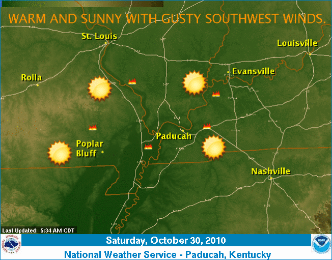
Our local weather summary - above - issued by the Paducah, National Weather Service Office.
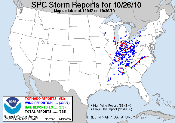
Let's take a look at some updated maps from the outbreak - there have been several more tornado reports added to the list. Quite the event. Thankfully I don't see any extreme weather in our near term pattern.


I will update the monthly outlook over the next few days. October will end up with above normal temperatures and below normal precipitation - just as forecast! Let's see if we can make it three in a row with the November forecast.
Couple of maps:
The departure for temperatures (all of the red/orange/yellow is above normal temps for the last 29 days)


On the above map - all the area in red/orange/yellow is below normal precipitation. VERY dry. More maps in the coming days.
One last set of maps - this is the jet stream position forecast for later this week (next Friday). Notice the buckling jet - bringing air down from Canada into our region. The second map is the GFS forecast for low temperatures next Friday night. Appears to be quite chilly. Click images, as always, for a larger view.


- Meteorologist Beau Dodson
McCracken County Office of Emergency Management
For the latest watches and warnings please visit your local National Weather Service Office http://www.weather.gov/organization.php
No comments:
Post a Comment