This site is non-profit and brought to you as a public service.
You can find more updates on my Facebook (under Beau Dodson) - Twitter, as well.
Bottom line it for me Beau...
For southern Illinois and far western Kentucky...
Severe or extreme weather risk for today: 0%
Severe or extreme weather risk for tonight: Slight chance for isolated severe storms
Severe or extreme weather risk for Thanksgiving Day - Slight risk during the morning hours.
Here is your morning radar - click here.
Freezing rain, sleet, or snow today, tonight, and tomorrow risk probabilities: 0% today, 0% tonight, and a good chance (60%) for a light mix of sleet and snow on Thursday afternoon or evening. No accumulation is expected.
A flood watch has been issued for portions of the region - please check your local NWS forecast office for additional information.
Wednesday: A period of chilly showers - possible thunderstorms this morning. Then a lull in the precipitation. High temperatures near 60 degrees.
Wednesday night: A chance for showers in the evening. Showers and thunderstorms becoming likely after midnight. A few strong storms will be possible. Temperatures steady or slowly rising. Breezy.
Thanksgiving: Cloudy with showers and thunderstorms likely. Rain may end as a brief period of mixed precipitation (sleet/snow/freezing rain). No accumulation is expected. High temperatures early in the day and then temperatures falling in the late afternoon (there is some disagreement among models on exactly what time the front will move through). High near 65-70 early and then temperatures falling into the 30s during the late afternoon period. Windy.
Thanksgiving night: Cloudy with a good chance for a mix of rain, sleet, and snow. Possibly a light period of freezing rain. No accumulation is expected. Windy. Temperatures falling into the 20s. Watch for slick spots on bridges and overpasses.
As you travel on Thursday and Thursday night please remember that bridges and overpasses can have slick spots on them much faster than other roadways. Any moisture left on pavement could freeze.
Rainfall totals (from last nights rain through Thursday night) across southern Illinois and western Kentucky from today into Friday will be in the 1-2" range with some higher amounts possible. Rainfall in the State of Kentucky will likely be in the 1.5-3.5" range. Again locally higher amounts are forecast - especially along the Ohio River Counties.
Here is the map from the NWS/HPC on forecasted rainfall totals. Note the heavy amounts in red.

Your local National Weather Service seven day forecast can be viewed by clicking here.
This is a complicated forecast and I would advise everyone to listen for updates. I will update the blog if changes are needed. Also check my Facebook posts.
Local and regional interactive radars can be viewed by clicking here.
Barometer reading this morning is in the 29.80-30.10" range. Last 24 hours of data - click here.
-----------------------
If you need to view forecasts for other areas or watches/warnings then click here.
Well forecasted event is underway. Precipitation has spread across our entire region this morning. Locally heavy showers and storms are being reported. As you travel north the precipitation is falling the form of a mixture of sleet and snow. Use caution.
The warm front will pass through our region today and this will usher in warmer air. Expect temperatures tonight to actually hold steady or rise. This will be a signal that additional showers and thunderstorms will be likely during the overnight hours and again on Thanksgiving Day.
Isolated strong or severe storms can not be ruled out later tonight and on Thursday morning before the cold front passes through our counties. You can view the official Storm Prediction Center outlook by clicking here.
A SHARP temperature drop will accompany the front. Temperatures could fall 20-30 degrees in just a few hours.
Here is a chart for Paducah, KY - this shows just how fast the temperature will fall on Thursday.

The precipitation will quickly change over to sleet and snow on Thursday afternoon and evening. Some light freezing rain is also possible. No accumulation is forecast. However, bridges and overpasses could have a few slick spots - especially if the sleet comes down at a faster rate than expected. I will monitor - but just use caution, as always.
Here is another map that shows the sharp temperature contrast across our region tomorrow morning at 7 a.m. Click for larger view - this image is from www.wright-weather.com

Then tomorrow afternoon (the map below) - you can see the cold air moving in from the west.

Then let's take a look at tomorrow evening - you can see the cold air pushing even further into Kentucky. This would be around 6-8 pm. There are some questions on the exact speed of the front. If it moves in faster then we may have to move up the time of arrival. But - you at least get the general idea of what we are looking at. Rain - lots of rain - then cold air quickly moves in and changes the precip to a light period of mixed precip.
Again - this map is tomorrow evening. Click for a large view. The map is from www.wright-weather.com Where I get most of my model data.

Here is how one model sees the changeover on Thanksgiving Day - the blue is snow - pink/red is sleet or mixed precip. Again, no significant accumulation is forecast.
This map is for around noon tomorrow - that area if mixed precip will spread east with time.

Then around 2 pm tomorrow afternoon - this is how the NAM believes the radar will appear. Again - click all images for a larger view. The radar images are from www.wright-weather.com
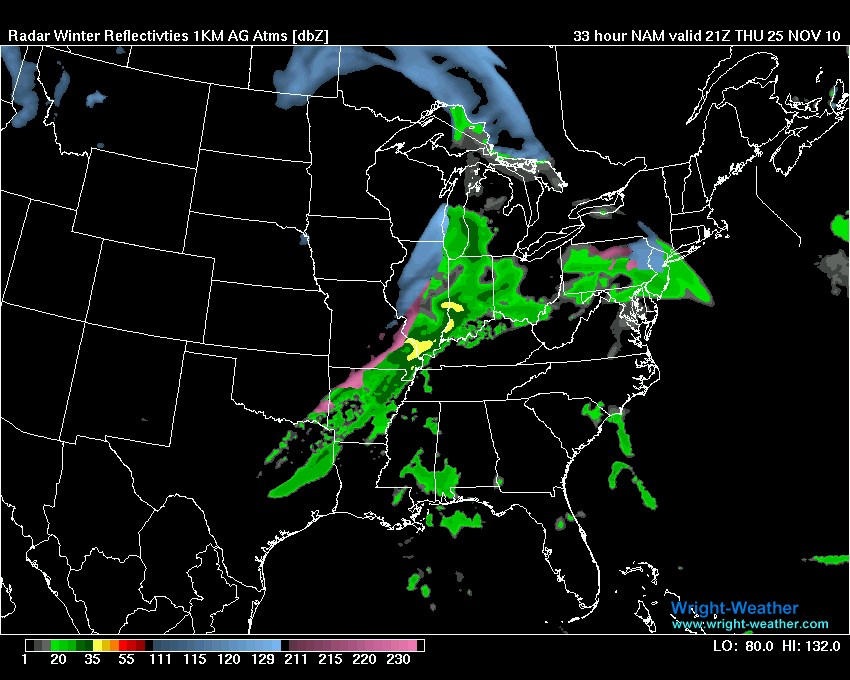
Then finally - these last two maps are for Thursday evening (ignore where it says Friday - that is in Zulu time). This would be around 5-8 pm tomorrow evening. You can see the little area of changeover at the end.

Thursday evening - late. Again - this might not be exactly how the radar will look. This is a model forecast. The blue area is snow or a mix of precipitation.

Friday into Saturday/Sunday will be dry. Colder. The next chance for precipitation will arrive on Monday and Tuesday. Thunderstorms are possible.
Also - for those further east in Kentucky - please visit Chris Bailey's forecast thoughts - click here.
Hope everyone will have a safe holiday!
- Meteorologist Beau Dodson
McCracken County Office of Emergency Management
For the latest watches and warnings please visit your local National Weather Service Office http://www.weather.gov/organization.php
No comments:
Post a Comment