Complicated forecast for the coming week - watch for updates Timing of the front on Thursday is in question. If it is slower then rain chances will last longer and the cold air will arrive later. Please check back for updates on that particular part of the forecast.
This site is non-profit and brought to you as a public service.
You can find more updates on my Facebook (under Beau Dodson) - Twitter, as well.
Bottom line it for me Beau...
For southern Illinois and far western Kentucky...
Severe or extreme weather risk for today, tonight, and tomorrow: 5%
Chance for freezing rain, sleet, or snow today, tonight, and tomorrow: 0%
Please do not burn trash or debris today - the strong winds could quickly cause a fire to get out of control.
Today - Mix of sun and clouds. Increasingly cloudy through the day. A few scattered showers late in the day. Windy. Mild. Near record high temperatures near 74 degrees. Winds from the south at 15-20 mph. Gusts to 35 mph.
Tonight - Cloudy. Showers and thunderstorms likely (especially from 8 pm through 6 am). A few heavy storms with gusty winds. Isolated severe storm can not be ruled out. Listen to NOAA Weather Radio or local media for updates. Low temperatures around 46 degrees. Winds south at 10-15 becoming west/northwest late at 10-15. Stronger gusts possible.
Tuesday - A mix of sun and clouds. Showers and thunderstorms ending during the morning hours. Cooler - high temperature near 55 degrees. Northeast winds at 5-10 mph.
Tuesday Night - Partly cloudy and colder. Low temperatures around 35 degrees.
Wednesday - A period of showers and thunderstorms redeveloping (most likely from late morning or early afternoon into the afternoon hours - along the warm front). A few strong storms can not be ruled out. Warmer. High temperatures near 60 degrees. Breezy. South winds at 10-15 mph.
Wednesday night - Showers and thunderstorms - widespread. Windy. Mild. Low temperatures steady or slowly rising through the night.
Thanksgiving - Cloudy. Showers and some thunderstorms - possibly strong very early in the day/morning. Temperatures will peak during the morning/early afternoon and fall late in the day. Rain may briefly mix with snow or snow pellets. (please see Chris Bailey's comments at the bottom of this page for areas to our east - where snow is more likely). High temperature around 66-68 during the morning hours. Temperatures falling into the 30s late in the day. Windy.
Friday - Sunday - Partly Sunny. Cooler. Highs in the 40s on Friday and Saturday and near 50 on Sunday. Low temperatures in the 20s for Friday morning and Saturday morning.
Rainfall totals across southern Illinois and western Kentucky from Monday afternoon into Friday will be in the 1-2" range with some higher amounts possible. Rainfall in the State of Kentucky will likely be in the 1.5-3.5" range.
Your local National Weather Service seven day forecast can be viewed by clicking here. Some of my forecast thoughts differ a just a little bit from the official NWS forecast. But, that is okay. No major differences. I think we are all in basic agreement on how this will all unfold.
This is a complicated forecast and I would advise everyone to listen for updates. I will update the blog if changes are needed. Also check my Facebook posts.
Local and regional interactive radars can be viewed by clicking here.
Barometer reading this morning is in the 29.80-30.10" range. Last 24 hours of data - click here.
-----------------------
Good morning everyone.
Lot of weather to deal with this week. I will spell out a few of the concerns.
A couple of storm systems will impact our region - the first storm system will be later today and tonight. A cold front will pass through our region tomorrow morning. Showers and thunderstorms will develop ahead of the cold front. A few strong or severe thunderstorms can't be ruled out. Listen for updates from NOAA Weather Radio and local media.
Cooler tomorrow - behind the front. High temperatures will likely be late tonight or early tomorrow morning. Then steady or falling temperatures. Wednesday will also be cooler - chilly in parts of the area.
Another system moves into our region on Wednesday and Wednesday night. Additional showers and thunderstorms will be possible across our entire region. A few strong to severe storms are possible on Wednesday night and early Thanksgiving morning. Stay tuned for updates.
It will be a windy week. It has been a windy 24 hours, as well. As you know.
We are going to be on a roller coaster ride when it comes to temperatures. Mild days - then cold front will move through the region with colder air - then warmer ahead of the next system - then colder with falling temperatures on Thanksgiving day. A cool weekend - nothing extreme. Expect some morning lows in the 20s on Friday morning into Saturday morning.
One item of interest - there is some model data that shows the rain ending as a snow/snow pellet mix or change over. This would be on Thursday and Thursday night for our region and areas to our east. It is too soon to make a call on this subject. I will keep an eye on the timing. Right now if there were to be any snow of concern it would most likely be to our east. I am not overly concerned - but will monitor.
If you have travel plans this week then I would advise you to plan ahead. Keep an eye on the severe threat - there could be a few watches and warnings before all is said and done. Keep an eye on the potential for wintry weather if you are traveling. I know everyone will be busy with cooking turkeys and having family gatherings. Please keep your NOAA Weather Radios on. If we do have severe weather then you will be prepared. :)
Remember that severe weather can occur in the fall and winter months. As a matter of fact - severe weather is quite common in our region during the fall and winter months.
A few maps for you this morning:
The official Storm Prediction Center outlook (see the image below) for tornadoes (our threat is more for the overnight hours). As you can see it is a 2% risk zone. So - not overly bullish on the severe risk. But - something we can't ignore either.

Meteorologists use what they call Skew T Soundings to look at the atmosphere. This is the sounding for tonight. The winds on the right hand side are strong - some turning of the winds. Also some CAPE (energy available). This sounding tells me that there is at least a small chance for severe storms tonight.

Now let's look at the 5 day rainfall prediction (see image below) from the HPC (a branch of NOAA and the NWS). You can see that quite a bit of rain is forecast for the Ohio Valley. We desperately need this rain. So - this is great news. Click the image to make it larger.

Here is what the WRF (a meso-scale model) is showing for tomorrow morning (late tonight). This model predicts what radar will look like at a certain hour (see the image below). This map represents what the model believes radar will look like tomorrow morning around 3 am. You can see some showers and thunderstorms in our area.

Remember how I have been telling you that we can expect a roller coaster pattern? The below images illustrate what I mean by that statement. Watch these "waves" of warmer temperatures slosh through our region (remember the atmosphere is a fluid). Then colder air behind the wave. This is a typical pattern in our region. The boundary between the cold and warm air will be placed right over our area. The maps below are from www.wright-weather.com You can click on the maps for a larger view. The time and date stamps are at the top right hand side. The time is in Zulu (the map below is for 18z Monday - which is Monday afternoon). Remember these are forecast maps - showing how the map is expected to look according to the computer model data.

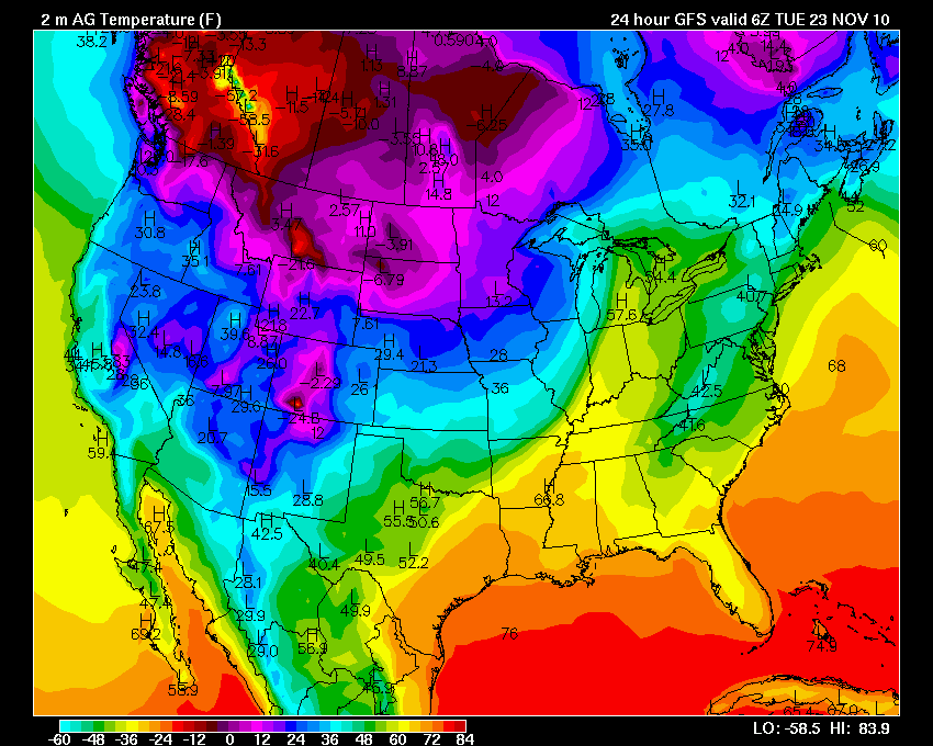
Early tomorrow morning (above map - 6z Tuesday which is late Monday night on our clocks) - you can see the wave of warmer air that is over us now starting to move east. Colder air will filter into our region (map below - which shows 6z Wednesday which is late Tuesday night on our regular clocks). But it won't last long. The time and date stamps are at the top right hand side. The time is in Zulu. Remember these are forecast maps - showing on the map is expected to look.

This map is for Tuesday night (above map - 6z Wednesday which is late Tuesday night). See how the colder air has filtered into our region. Not extreme - but colder. The warmer air is shunted off to the east and south. But - look to our southwest. The warm air is about to return! The map below is for 6z Thursday which is basically late Wednesday night on our regular clocks.

Wednesday night (map shows 6z Thursday - which is late Wednesday night) - above image - a tongue of warmer air spreads into our region ahead of a strong cold front. But - don't get used to the mild air. Cold air will rush in behind the front (map below). The next map will be Thursday afternoon (18z is the time stamp). As you can see - falling temperatures after a mild start.

So - there you have it. A roller coaster pattern. Severe weather threat is low - but can't be ruled out either. A tricky forecast with timing all of this. Stay tuned for updates. I will keep an eye on the situation. WPSD, WSIL, and KFVS is also watching all of this. The NWS will be updating forecasts on a regular basis.
For those further east in our region - please check out Chris Bailey's forecast. He has things covered for other parts of the region. You can view that information here - http://www.kyweathercenter.com/
- Meteorologist Beau Dodson
McCracken County Office of Emergency Management
For the latest watches and warnings please visit your local National Weather Service Office http://www.weather.gov/organization.php
No comments:
Post a Comment