Complicated forecast for the coming week - watch for updates
This site is non-profit and brought to you as a public service.
You can find more updates on my Facebook (under Beau Dodson) - Twitter, as well.
Bottom line it for me Beau...
For southern Illinois and far western Kentucky...
Severe or extreme weather risk for today, tonight, and tomorrow: 2%
Severe or extreme weather risk for Monday night: 5%
Chance for freezing rain, sleet, or snow today, tonight, and tomorrow: 0%
Today - Some morning fog - use caution. Increasing clouds to mostly cloud sky conditions. Mild. High temperature around 64 degrees. South winds 10-15 mph gusts to 25.
Tomorrow - Mostly Cloudy. A 40% chance for showers late. Mild. High temperature near 70 degrees. South winds 10-15 mph.
Monday night: Widespread showers and thunderstorms. A few heavy. Mild - low temperatures in the 50s.
Tuesday - Cloudy. A chance for showers will continue. Mild temperatures. High near 62 degrees.
Tuesday night into Wednesday night - chance for showers and thunderstorms - especially on Wednesday night. Chance of rain 80% Wednesday night. Colder Tuesday night then temperatures rising again late Tuesday night into Wednesday morning. We will be on the boundary. Colder across our northern counties.
Thanksgiving into the weekend - Lower confidence in this time period. Rain likely on Thanksgiving day. Perhaps ending as a mix of snow and rain on Thursday evening and Thursday night over portions of the region. Much colder. Highs in the 30s on Thursday and in the 40s on Friday and Saturday. Windy conditions, as well.
Rainfall totals across southern Illinois and western Kentucky from Monday into Friday will be in the 1-2" range with some higher amounts possible. Rainfall in the State of Kentucky will likely be in the 1.5-3.5" range. Heavier as you move a little bit east of our immediate Paducah area. This will need to be tweaked over the coming days.
Your local National Weather Service seven day forecast can be viewed by clicking here. We don't totally agree today on how Thursday ends up. We will see how it goes. But keep that in mind if you see something different on that link vs what I am saying above. Forecasters don't always agree 100% on everything. And - that is okay.
Local and regional interactive radars can be viewed by clicking here.
Barometer reading this morning is in the 29.90-30.20" range. Last 24 hours of data - click here.
-----------------------
Good morning everyone!
Today is our holiday open house! So, it is busy around here. I hope everyone can come out and see the weather observatory and meet my family.
Let's get ready for a weather roller coaster ride. Some wild swings are ahead of us. So - buckle up and let's all keep our hands and feet inside the car at all times. :) We want everyone to have a safe holiday weekend. We know that rain can produce slick roads - just as much as other precipitation types. Especially after a drought when there has been a lot of oil buildup on the roads.
Right off the bat let's look at the official 5 day rainfall forecast from the HPC (National Weather Service and NOAA) - I am expecting widespread 1-2" rains over our region. GREAT news! We need to relieve this drought. Click all of the images to see them in a larger view.

And if we just look at the Wednesday evening into Friday time frame. Day 4 and 5. Check this map out!

We are entering an unsettled weather pattern. A roller coaster of sorts - temperatures will be mild today and on Monday/Tuesday. A storm system will approach and move through our area on Monday night into Tuesday night. This will trigger showers and thunderstorms. A few strong storms can't be ruled out. I am not currently overly excited about the severe weather threat.
The Paducah, KY National Weather Service would like to remind everything that severe weather and tornadoes can occur during every month of the year. Some of our deadliest tornadoes occur during winter. This may surprise some people - but that statistics back this up. If you don't have a Midland NOAA Weather Radio then you should buy one. You can get them at Wal Mart and through Amazon.com (among other places).
Officially the Storm Prediction has used placed in a general thunderstorm threat for Monday into Tuesday. Again, we will have to monitor this situation. Isolated tornadoes can not be ruled out. An upgrade to a slight risk is possible tomorrow and tomorrow night.

A second system will develop over Oklahoma and Arkansas on Wednesday. This will strengthen and move along the stalled front (that will be over our region). Additional showers and thunderstorms will be possible with this second system. Right now the threat for severe weather appears low. However, this is going to have to be carefully monitored. Please check back for updates.
Cold weather will return on Thanksgiving Day and into the weekend. We have been anticipating this for some time. I actually thought November might turn out below normal in the temperature department. However, that looks unlikely. I should have stuck with my original forecast. September and October turned out as expected. I will miss the November temperature forecast! It appears we will end up above normal. That would make the entire fall above normal (September through November).
There are major questions on the Wednesday night into Thursday night time frame. Whether the front produces a third storm system. So, my confidence on how this unfolds is low (for that time period). I would advise you to check for updates. I know it is a busy holiday travel week. There could be some headaches.
Expect the roller coaster pattern to continue into December. This is not unusual for our region. If you remember in the fall and winter outlooks we discussed this.
I am not seeing any strong signals for a snowstorm - just yet. I am seeing hints of some snowstorms on the model data. However, they are in the long range. I will keep an eye on the threats and update accordingly. I will also be keeping an eye on what happens on Thursday - if there will be some sort of transition from rain to snow across portions of the region. Still a bit early to make a call on that subject.
You can read the latest hazardous weather outlook issued by the Paducah, KY National Weather Service Office by clicking here.
Don't forget you can view all of our local emergency management streams and weather conditions - much more - by clicking here.
A few graphics this morning:
This is what the NAM model (one of the models I use to forecast weather) is showing for the Monday night event. This wonderful map is from www.wright-weather.com I use them frequently for my model information. Great site. The pink/purple/blue areas are rainfall. The blue is heavier rain. Click for larger image. You can see the low and the associated precipitation.

Now let's look ahead to the next storm - Tuesday night and Wednesday. This is from the GFS - again www.wright-weather.com Click for larger view.

And if we want to look FAR out into the future - remember that I have tried to teach everyone that long range models have poor performance skill. However, it is something I keep an eye on. They don't always verify. But, I will watch all of this in the coming days. Let's just put a sticky note in our head - and return to this system in a few days and see what the GFS (model) has done with it. If that map were to verify then we would have to think about frozen precipitation. Click for larger view.

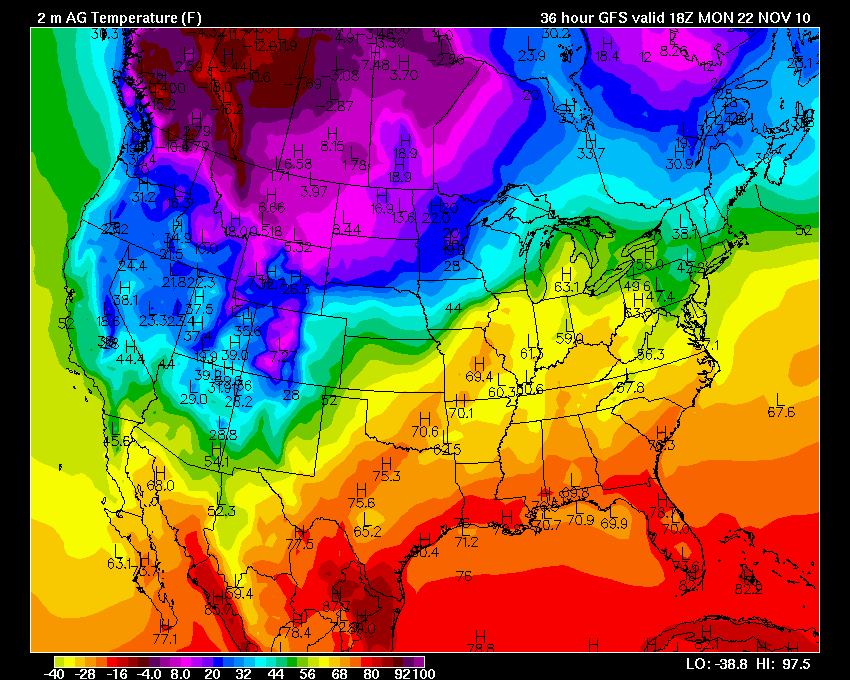
Temperatures on Monday afternoon. Let's keep thinking about that roller coaster pattern.

Now check out Wednesday temperatures. Warm again! Cold air building to our north - like a dam. Is it going to break?

Boom - cold air dam breaks and here it comes. Just in time for Thanksgiving. Cold on Thanksgiving is okay? I think so. Makes it feel like the holidays.
Chris Bailey is hitting this storm on his blog, as well. I encourage those further east in Kentucky to check out his updates. Click here.
Next storm system should be around November 30th. Also watching a system for around December 5-7th. Long way off - but keeping an eye on the potential for a winter storm in the central United States. Stay tuned.
- Meteorologist Beau Dodson
McCracken County Office of Emergency Management
For the latest watches and warnings please visit your local National Weather Service Office http://www.weather.gov/organization.php
No comments:
Post a Comment