This site is non-profit and brought to you as a public service.
You can find more updates on my Facebook (under Beau Dodson) - Twitter, as well.
A quick update as I am on my way to the Winter Weather Conference! Can't wait to hear the latest from the Paducah, NWS on this past year and the upcoming winter. I always enjoy these events.
Bottom line it for me Beau...
For southern Illinois and far western Kentucky...
Severe or extreme weather risk for today, tonight, and tomorrow: 0%
Today - Quite a few clouds. Cool. High temperature near 55 degrees. South winds at 5 mph.
Tonight - A period of showers or light rain. Cool. Low near 39 degrees. West winds 5-10 mph.
Tomorrow - Quite a few clouds around - especially early in the day. Cool once again. High temperature only near 48 degrees. Northwest wind at 5 mph.
Your local seven day forecast can be viewed by clicking here.
Local and regional interactive radars can be viewed by clicking here.
Barometer readings today will range from around 29.90-30.15". Last 24 hours of data - click here.
-----------------------
Well, it finally rained - at least over half of the region. The other half basically received nothing. Feast or famine? That is what I always say.
Here is what the Paducah, Kentucky radar showed for rainfall totals - radar is not 100% accurate on evaluating totals. But you can get the general idea.

I was about one county off in my forecast. I thought Carbondale and Marion would receive a bit more rain. Otherwise we were just about right on the forecast amounts. Areas near Kentucky Lake received up to 1" (some areas more than that) and the Paducah and Metropolis area received anywhere from 0.50-0.70". Not bad and much needed.
I do feel sorry for those who did not receive any rainfall. We all need rain and we are all in drought. This was a great opportunity for the region to pick up a nice soaking rain. I noticed Jim Rasor said (WSIL) that they had a trace or no rain at all at his location. Frustrating - I know.
Here is a satellite view of the storm that passed through here on Tuesday. Impressive.

Looking ahead - tonight another system will pull in from the northwest. This will spread an area of light rain across portions of our local region. The majority of the precipition is expected to fall across southeast Missouri, southern Illinois, southwest Indiana, and then into northern and central Kentucky.
This is a weak system. No severe weather is expected. Only some light rainfall. Totals should be less than 0.25". Some areas across the southern portion of our region will receive very little rainfall.
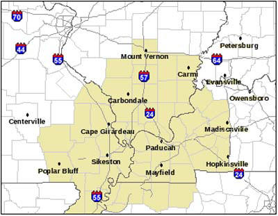
Today's weather map:

The area shaded in below is basically the area I forecast for - mostly the central part of that map. But, I try to touch on areas around us.
Looking ahead - the weekend should be fine (see the seven day outlook). The next chance for showers will arrive next week - perhaps two chances. I am not seeing anything that appears extreme or out of the ordinary. Some cold air shots. But - there will be days where the temperature will be above normal next week. So, it won't be cold allllllll week long. Sort of a roller-coaster pattern (where have we heard this before).
Right now - and this is quite a ways off - Thanksgiving appears to be cloudy and cool. I am uncertain of the timing of the big cold front next week. It will be mild ahead of the front and cold behind the front. So, depending on where that boundary is located will help dictate our forecast. Stay tuned!
I will likely be wrong on November turning out a bit below normal in the temperature department. We have had just too many warm days. I guess I should have stuck with my original call for above normal temperatures all the way into the middle of November.
At least I did get the more active pattern correct for the middle and end of November. We desperately need the rain. More active = more precipitation!
I took this photograph on Monday. This was ahead of our low pressure that moved through on Tuesday. Nice clouds! Click for a large view. I am having a holiday open house up here at the Weather Observatory on Sunday - noon to five. All are welcome to come and see the place. Come and see where I put together my forecasts.

Winter weather preparedness week has arrived. If you missed the winter forecast post then click here.
I am also using a winter storm rating system (and ice storm rating scale) during the upcoming winter season. If you would like to see the category risks then click here.
The Paducah, KY National Weather Service would like to encourage you to be prepared this winter for all modes of severe weather. That includes snow, ice, and severe thunderstorms. You can read more about that topic by visiting this site - click here.
I work closely with the local NWS and news station meteorologists to bring you the best coverage possible for emergency management, for our spotter groups, and for updating the outlooks. We all work as a team - bringing you the most accurate weather possible.
- Meteorologist Beau Dodson
McCracken County Office of Emergency Management
For the latest watches and warnings please visit your local National Weather Service Office http://www.weather.gov/organization.php
No comments:
Post a Comment