Monday night and Tuesday update
.
For more frequent updates check out our weather Facebook page - click here and hit like at the top of the page.
.
This page is best viewed with Mozilla Firefox. There could be issues with spacing on Internet Explorer
.

.
Here are my current personal forecast thoughts for far southern Illinois and western Kentucky...
.
Monday night: Mostly clear skies - very mild for early April.
Above normal temperatures
Lows: in the lower to middle 60s | Normal lows for this time of the year are around 42 degrees.Above normal temperatures
Wind: Light winds
Precipitation probability - 0% | Rainfall totals: 0"
Confidence in this forecast is very high
.
Tuesday: A mix of sun and clouds. A chance for showers and thunderstorms during the afternoon hours. Very warm for early April.
Above normal temperatures
Highs: around 78-84 degrees. | Normal highs for this time of the year are around 65 degrees.Above normal temperatures
Wind: Southwest winds at 10 mph
Precipitation probability - 40% | Rainfall totals: 0.25"-0.50" - as always thunderstorms can produce locally heavy rain
Confidence in this forecast is very high
.
Tuesday night: Partly cloudy skies. A chance for showers and thunderstorms.
Above normal temperatures
Above normal temperatures
Lows: in the lower 60s | Normal lows for this time of the year are around 42 degrees.
Wind: Northwest at 5 mph
Precipitation probability - 40% | Rainfall totals: 0.25"-0.50"
Confidence in this forecast is high
Wind: Northwest at 5 mph
Precipitation probability - 40% | Rainfall totals: 0.25"-0.50"
Confidence in this forecast is high
.
Wednesday: Mostly cloudy with scattered showers and thunderstorms. Not quite as warm as recent days - but still well above normal temperatures.
Above normal temperatures
Highs: around 75 degrees | Normal highs for this time of the year are around 65 degrees.Wind: Southwest at 5-15 mph
Precipitation probability - 60% | Rainfall totals: 0.25"-0.50"
Confidence in this forecast is high
.
Don't forget to sign up for the severe weather "heads up" email list - I usually email everyone before a big event - severe weather - tornado outbreaks - winter storms - ice storms. Click here to join
.

.
.
Don't forget to sign up for the severe weather "heads up" email list - I usually email everyone before a big event - severe weather - tornado outbreaks - winter storms - ice storms. Click here to join
.
.

There will be an increasing chance for thunderstorms over the next few days. Although widespread severe weather is not anticipate there could be a few reports of large hail and gusty winds. Lightning will be a concern, as well.
.

Monitor for changes in weather conditions - there could be a severe thunderstorm or two over the next few days - especially during the afternoon peak heating times. Lightning is, of course, always a concern for any outdoor events. When thunder roars - go indoors!
.

There are no major wild cards in this forecast.
.
.

.
No major changes in this update!
.

.
Forecast for your local town/city - Click Here
.
..
Join me on Facebook for more frequent updates on the weather in our local areaClick Here. I also strongly encourage you to FRIEND some of the local media meteorologists - I follow all of them and so should you.
.
---

The forecast for severe or extreme weather
.
The McCracken County Office of Emergency Management reminds you that owning a NOAA All Hazards Weather Radio is the best way to receive notifications of severe weather watches and warnings.
.
Remember that the National Weather Service defines a severe thunderstorm as one that produces 58 mph winds or higher, hail 1" in size or larger, and/or a tornado. More information with some slides concerning reporting severe weather - click here
.
For the most up to date severe weather outlooks - click here.
or
Visit the Storm Prediction Center's web-site - click here
.
Monday night: Severe weather is not anticipated. No snow or ice.
Monday night: Will there be a chance for non-severe thunderstorms? No
.
.
Monday night: Severe weather is not anticipated. No snow or ice.
Monday night: Will there be a chance for non-severe thunderstorms? No
.
Tuesday: An isolated severe thunderstorm will be possible - the main concern would be large hail and gusty winds.
Tuesday: Will there be a chance for non-severe thunderstorms? Yes
.Tuesday: Will there be a chance for non-severe thunderstorms? Yes
Tuesday night : An isolated severe thunderstorm will be possible early - the main concern would be large hail and gusty winds.
Tuesday night: Will there be a chance for non-severe thunderstorms?Yes
.
Wednesday: Severe weather is not anticipated. No snow or ice.
Wednesday: Will there be a risk for non-severe thunderstorms? Yes
.
To view storm reports from today and yesterday - click here
.
.
 .
.
Will the Storm Prediction Center issue a tornado or severe thunderstorm watch for southeast Missouri, southern Illinois, or western Kentucky?
.
Tonight - No
Tuesday - Very small chance
Tuesday night - Very small chance
Wednesday: Will there be a risk for non-severe thunderstorms? Yes
.
To view storm reports from today and yesterday - click here
.
.
Will the Storm Prediction Center issue a tornado or severe thunderstorm watch for southeast Missouri, southern Illinois, or western Kentucky?
.
Tonight - No
Tuesday - Very small chance
Tuesday night - Very small chance
Wednesday - No
Thursday - No
Friday - No
Saturday - No
.
To view the official Storm Prediction Center's web-site - click here Alternative link - click here
.
To view the official Storm Prediction Center's web-site - click here Alternative link - click here

.
To view all watches and warnings in IL - Click Here
To view all watches and warnings in KY - Click Here
To view all watches and warnings in MO - Click Here
To view all watches and warnings in TN - Click Here
All other states- Click Here
To view all watches and warnings in IL - Click Here
To view all watches and warnings in KY - Click Here
To view all watches and warnings in MO - Click Here
To view all watches and warnings in TN - Click Here
All other states- Click Here
.
The links above are interactive and you can move around the United States by simply clicking on the national map - or from the pull down menu where it says regions and US States.
.
To view the interactive warning map - click here.
.
.
 .
.
The Weather Observatory is a strong partner with the National Weather Service - click here to visit your local NWS web-site. For the most up to date warnings/advisories hit refresh on their page.

.
To view the interactive warning map - click here.
.
.
The Weather Observatory is a strong partner with the National Weather Service - click here to visit your local NWS web-site. For the most up to date warnings/advisories hit refresh on their page.
This forecast analysis covers far southern Illinois, southeast Missouri, southwest Indiana, western Kentucky, and northwest Tennessee
.
HEADLINES: Right off the bat - let me remind you that the National Weather Service will be holding several advanced spotter classes over the coming weeks. I encourage you to sign up!
 You can view more about these classes by CLICKING HERE
Okay - now back to the weather at hand!
WARM TEMPERATURES! How many days have I said those words? Weeks on end. The warm weather continues with record breaking temperatures over our region.
Above normal temperatures also cover a large section of the United States. Just how large? Let's take a look at the map that shows us where above or below normal temperatures are occurring.
The area with positive numbers are above normal - that number tells you how many degrees above normal we are. Normal highs for this time of the year are around 60-65 degree. We are well above those temperatures.
You can see cooler air - below normal temperatures across a small part of the northeastern United States and back over the western U.S.
 Visible satellite shows a lot of sunshine over our area this afternoon (Monday afternoon)

And here is the water vapor imagery - you can see the next system to our south and west
 Note the brighter colors on the disturbance moving out of Texas and Louisiana - those are thunderstorms. That system is drifting northward. The moisture to our west is the cold front and low pressure area moving over Canada - you can see a DEEP area of low pressure wound up off the coast of Canada/Pacific northwest, as well.
Let's look at that closer - talk about wound up!

 That system is not a concern for our region right now - but I just thought it was a pretty cool satellite image!
On Tuesday an upper level low and low pressure area will move well to our north - a weak disturbance will cross our region and could spark a few showers and thunderstorms. If storms do form they could produce large hail and gusty winds - the confidence is low on that part of the forecast.
A closed low will approach our region on Tuesday night into Thursday. This well advertised system will bring a chance for several periods of showers and thunderstorms. It won't rain all the time - but there will be on and off chances for precipitation. Most areas should pick up a least a little bit of rainfall.
Keep in mind that locally heavy thunderstorms can produce pockets of rainfall totals in excess of 0.50"
The severe weather risk on Wednesday into Thursday appears low. Instability may be a limiting factor - especially if clouds and some precipitation persists. I will monitor and update if there are changes (check the video each morning on my Facebook page). Remember the blog is updated in the afternoon and videos are updated each morning. The Facebook page has the most up to date information - click here.
Temperatures will remain above normal into the weekend.
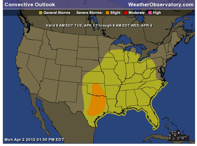
Here is the Storm Prediction Center's forecast for severe weather tonight (Monday night). The second graphic is Tuesday's outlook - subject to change in future updates.
We are in a general risk for thunderstorms on Tuesday (general means they are not forecast to produce severe weather - although an isolated severe storm will be possible - again large hail and gusty winds would be the primary concern).
The yellow area represents general thunderstorms
The orange area represents the slight risk area for severe storms
 And for Tuesday
 Here are the temperatures forecasts for Tuesday and Wednesday - warm to continue! Temperatures will moderate a little bit on Wednesday with more clouds in the region (thus a bit lower temperatures - although still above normal for this time of the year).

 And let's take a look at the departures - how much above normal will temperatures be over the next 2 days?


.
HEADLINES: Right off the bat - let me remind you that the National Weather Service will be holding several advanced spotter classes over the coming weeks. I encourage you to sign up!
Okay - now back to the weather at hand!
WARM TEMPERATURES! How many days have I said those words? Weeks on end. The warm weather continues with record breaking temperatures over our region.
Above normal temperatures also cover a large section of the United States. Just how large? Let's take a look at the map that shows us where above or below normal temperatures are occurring.
The area with positive numbers are above normal - that number tells you how many degrees above normal we are. Normal highs for this time of the year are around 60-65 degree. We are well above those temperatures.
You can see cooler air - below normal temperatures across a small part of the northeastern United States and back over the western U.S.
And here is the water vapor imagery - you can see the next system to our south and west
Let's look at that closer - talk about wound up!
On Tuesday an upper level low and low pressure area will move well to our north - a weak disturbance will cross our region and could spark a few showers and thunderstorms. If storms do form they could produce large hail and gusty winds - the confidence is low on that part of the forecast.
A closed low will approach our region on Tuesday night into Thursday. This well advertised system will bring a chance for several periods of showers and thunderstorms. It won't rain all the time - but there will be on and off chances for precipitation. Most areas should pick up a least a little bit of rainfall.
Keep in mind that locally heavy thunderstorms can produce pockets of rainfall totals in excess of 0.50"
The severe weather risk on Wednesday into Thursday appears low. Instability may be a limiting factor - especially if clouds and some precipitation persists. I will monitor and update if there are changes (check the video each morning on my Facebook page). Remember the blog is updated in the afternoon and videos are updated each morning. The Facebook page has the most up to date information - click here.
Temperatures will remain above normal into the weekend.
Here is the Storm Prediction Center's forecast for severe weather tonight (Monday night). The second graphic is Tuesday's outlook - subject to change in future updates.
We are in a general risk for thunderstorms on Tuesday (general means they are not forecast to produce severe weather - although an isolated severe storm will be possible - again large hail and gusty winds would be the primary concern).
The yellow area represents general thunderstorms
The orange area represents the slight risk area for severe storms
We have a TON of new weather maps on the Weather Observatory web-site - these include temperatures, wind speed, dew points, heat index, barometric pressure, predicted rainfall, climate forecast, medium and long range maps, forecasts and more! Click here
.
 .
.
We have a number of new radars available on our Weather Observatory web-site!
---
We now offer St Louis, Mt Vernon, Evansville, Poplar Bluff, Cape Girardeau, Marion, Paducah, Hopkinsville, and Dyersburg Interactive City Radars. We also have the two regional radars and now offer you three GR Earth radars.
Click here for our radar page - WEATHER RADARS---
---
We also have a new interactive radar - you can view that radar by clicking here.
. We have a number of new radars available on our Weather Observatory web-site!
---
We now offer St Louis, Mt Vernon, Evansville, Poplar Bluff, Cape Girardeau, Marion, Paducah, Hopkinsville, and Dyersburg Interactive City Radars. We also have the two regional radars and now offer you three GR Earth radars.
Click here for our radar page - WEATHER RADARS---
---
We also have a new interactive radar - you can view that radar by clicking here.
.
Want to learn more about how to use our radars? I made a how to video with more information
Click here - http://www.youtube.com/watch?v=bfLa0hI3adU
.
.
-----------------------------
.

.
Let's check out the how much rain is forecast to fall over the next 48 hours. This map gives you a general broad brushed idea of what can be expected. Remember the scale is at the top of the map.
.
If you would like to view the most up to date 24, 48, 72, and 120 hour precipitation forecast maps then click here.
First - here is the 5 DAY totals - quite a bit of rain being indicated by some of the data - we will see how it goes.
 Here is the 48 hour total forecast


.
If you would like to view the most up to date 24, 48, 72, and 120 hour precipitation forecast maps then click here.
First - here is the 5 DAY totals - quite a bit of rain being indicated by some of the data - we will see how it goes.


.
You can also now view the probability of X amount of rain (you pick the value on the web-site) in a six hour period of time. Those maps can be viewed here.
.
You can view drought maps on the Weather Observatory web-site by clicking here.
.

Current conditions - including temperatures, apparent temperatures, heat index, wind chill, wind, pressure, humidity, dew points, and more - click here
.
You can also now view the probability of X amount of rain (you pick the value on the web-site) in a six hour period of time. Those maps can be viewed here.
.
You can view drought maps on the Weather Observatory web-site by clicking here.
.
Current conditions - including temperatures, apparent temperatures, heat index, wind chill, wind, pressure, humidity, dew points, and more - click here
.

.
You can view the upcoming days high temperature and low temperature forecasts by clicking here - choose the day - click on your state to zoom in
.
To view recent records that have been broken - click here
.
.
You can view the upcoming days high temperature and low temperature forecasts by clicking here - choose the day - click on your state to zoom in
.
To view recent records that have been broken - click here
.
.
---

.
Date Range: April 9th-14th
Event: Perhaps a shot at cooler air
Severe Risk:
Frozen Precipitation Risk: No
Details: A chance for a shot at cooler temperatures chances.
Confidence in my forecast: Medium
.
Date Range: April 13th-17th
Event: A larger scale system to impact the central United States
Severe Risk: Yes - possible event.
Frozen Precipitation Risk: No
Details: long range cycle forecast indicates the potential of a larger scale event during these dates.
Confidence in my forecast. Low
Date Range: April 17th-30th
Event: Unsettled weather - several cold frontal passages
Severe Risk: Yes - possible
Frozen Precipitation Risk: No
Details: Unsettled weather.
Confidence in my forecast. Low
Date Range: May 5th-11h
Event: Unsettled weather
Severe Risk: Possible
Frozen Precipitation Risk: No
Details: Unsettled weather.
Confidence in my forecast. Low
.
Date Range: May 29th-June 3rd
Event: A larger scale system to impact the central United States
Severe Risk: Yes - possible event.
Frozen Precipitation Risk: No
Details: long range cycle forecast indicates the potential of a larger scale event during these dates.
Confidence in my forecast. Low
More information on the long range cycle
.
.
Remember that as a general policy, in the long range outlook, I try not to mention severe thunderstorms more than 72 hours in advance (unless the signal is so overwhelmingly convincing that it warrants a mention). I will mention thunderstorm risks and I will give as many details as possible. Also remember you can view the long range severe weather outlooks by visiting the Storm Prediction Center's web-site - click here
.
-----------------------------
.
1. Once we move past the upper level system that will cross our region on Wednesday and Thursday the weather should be a bit more on the calm side. Friday should be dry - although I will be watching to make sure a few showers don't linger.
Saturday should be dry, as well - nice.
Sunday a cold front will approach from the northwest. This could spark a few showers and thunderstorms. Watch for updates.
Here is what the GFS model is showing for Saturday night and Sunday - the pink area represents precipitation. You can see most of the energy pulling away into Canada - but it does drag a cold front through are region.
This images is off of www.wright-weather.com (my favorite spot for weather model data) Click image for real size view.

Some of the data indicates the possibility for a period of cooler/colder weather towards the second and third week of the month. Those with agricultural interests should monitor for later updates.
Now is a GREAT time to buy a NOAA All Hazards Weather Radio. Better to have one before storms strike than to be without one during an event. I recommend the Midland Model 300 NOAA All Hazards Weather Radio - that is what I use here at my house!
.
Meteorologist Beau DodsonMcCracken County Office of Emergency Management
.

.
Beau Dodson Weather - Facebook
.

To view all watches and warnings in Illinois - Click Here
To view all watches and warnings in Kentucky - Click Here
To view all watches and warnings in Missouri - Click Here
To view all watches and warnings in Tennessee - Click Here
.
All other states- Click Here
.
For the latest watches and warnings please visit your local National Weather Service Office web-site.
http://www.weather.gov/organization.php
.
Remember most of the maps on the blog can be viewed on Weather Observatory Web-Site
.

.
No comments:
Post a Comment