Thursday evening into Friday update
.
For more frequent updates check visit my weather Facebook page - click here and hit like at the top of the page.
.
Remember that each morning I put together a weather video - between 8 am and 10 am - to view - click here
You can also subscribe to those videos on my YouTube page - that means you will receive an email notification when I update the video (upload a new one) - click here for more information

.
This blog is best viewed with Mozilla Firefox. There could be issues with spacing on Internet Explorer
.

.
Here are my current personal forecast thoughts for far southern Illinois and western Kentucky...
.
Thursday night: An increase in clouds late.
Above normal temperatures
Lows: in the middle 50s | Normal lows for this time of the year are around 47 degrees.Above normal temperatures
Wind: South winds at 5-10 mph.
Precipitation probability - 0% | Rainfall totals: 0"
Confidence in this forecast is very high
.
Friday: Mostly cloudy skies with a good chance for showers and perhaps a rumble of thunder. Temperatures will be falling during the afternoon hours - turning cooler, as well.
Below normal temperatures
Highs: around 65-70 degrees. | Normal highs for this time of the year are around 70 degrees.Below normal temperatures
Wind: Southwest winds at 10-15 mph - winds will be turning more westerly during the afternoon hours.
Precipitation probability - 70% | Rainfall totals: 0.25"
Confidence in this forecast is very high
.
Friday night: Mostly cloudy with a chance for some showers and perhaps a rumble of thunder - mainly early.
Above normal temperatures
Above normal temperatures
Lows: in the middle to upper 40s | Normal lows for this time of the year are around 47 degrees.
Wind: Northwest winds at 10-20 mph
Precipitation probability - 70% | Rainfall totals: 0.25"
Confidence in this forecast is high
Wind: Northwest winds at 10-20 mph
Precipitation probability - 70% | Rainfall totals: 0.25"
Confidence in this forecast is high
.
Saturday: Mostly cloudy skies - a chance for partly cloudy skies during the afternoon hours. Cooler - a bit breezy at times.
Below normal temperatures
Highs: around 60-65 degrees | Normal highs for this time of the year are around 70 degrees.Wind: Northerly at 5-15 mph - gusts to 20 mph
Precipitation probability - 20% | Rainfall totals: 0"
Confidence in this forecast is high
.
Don't forget to sign up for the severe weather "heads up" email list - I usually email everyone before a big event - severe weather - tornado outbreaks - winter storms - ice storms. Click here to join
.

.
.
Don't forget to sign up for the severe weather "heads up" email list - I usually email everyone before a big event - severe weather - tornado outbreaks - winter storms - ice storms. Click here to join
.
.

No major concerns
.

No major concerns.
.

The wild card in this forecast will be Saturday's weather. There could be a few showers linger in the area (eastern sections) - right now I went with mostly cloudy skies. Will monitor. It will definitely be cooler on Saturday - behind the cold front.
.
.

.
No major changes in this update!
.

.
Forecast for your local town/city - Click Here
.
..
Join me on Facebook for more frequent updates on the weather in our local areaClick Here. I also strongly encourage you to FRIEND some of the local media meteorologists - I follow all of them and so should you.
.
---

The forecast for severe or extreme weather
.
The McCracken County Office of Emergency Management reminds you that owning a NOAA All Hazards Weather Radio is the best way to receive notifications of severe weather watches and warnings.
.
Remember that the National Weather Service defines a severe thunderstorm as one that produces 58 mph winds or higher, hail 1" in size or larger, and/or a tornado. More information with some slides concerning reporting severe weather - click here
.
For the most up to date severe weather outlooks - click here.
or
Visit the Storm Prediction Center's web-site - click here
.
Thursday night: Severe weather is not anticipated. No snow or ice.
Thursday night: Will there be a chance for non-severe thunderstorms? No
.
.
Thursday night: Severe weather is not anticipated. No snow or ice.
Thursday night: Will there be a chance for non-severe thunderstorms? No
.
Friday: Severe weather is not anticipated. No snow or ice.
Friday: Will there be a chance for non-severe thunderstorms? A chance for a rumble of thunder during the late afternoon hours.
.Friday: Will there be a chance for non-severe thunderstorms? A chance for a rumble of thunder during the late afternoon hours.
Friday night : Severe weather is not anticipated. No snow or ice.
Friday night: Will there be a chance for non-severe thunderstorms? A chance for a rumble of thunder.
.
Saturday: Severe weather is not anticipated. No snow or ice.
Saturday: Will there be a risk for non-severe thunderstorms? No
.
To view storm reports from today and yesterday - click here
.
.
 .
.
Will the Storm Prediction Center issue a tornado or severe thunderstorm watch for southeast Missouri, southern Illinois, or western Kentucky?
.
Tonight - No
Friday - No
Saturday: Will there be a risk for non-severe thunderstorms? No
.
To view storm reports from today and yesterday - click here
.
.
Will the Storm Prediction Center issue a tornado or severe thunderstorm watch for southeast Missouri, southern Illinois, or western Kentucky?
.
Tonight - No
Friday - No
Saturday - No
Sunday - No
Monday - No
Tuesday - No
.
To view the official Storm Prediction Center's web-site - click here Alternative link - click here
.
To view the official Storm Prediction Center's web-site - click here Alternative link - click here

.
To view all watches and warnings in IL - Click Here
To view all watches and warnings in KY - Click Here
To view all watches and warnings in MO - Click Here
To view all watches and warnings in TN - Click Here
All other states- Click Here
To view all watches and warnings in IL - Click Here
To view all watches and warnings in KY - Click Here
To view all watches and warnings in MO - Click Here
To view all watches and warnings in TN - Click Here
All other states- Click Here
.
The links above are interactive and you can move around the United States by simply clicking on the national map - or from the pull down menu where it says regions and US States.
.
To view the interactive warning map - click here.
.
 .
.
The Weather Observatory is a strong partner with the National Weather Service - click here to visit your local NWS web-site. For the most up to date warnings/advisories hit refresh on their page.
.
To view the interactive warning map - click here.
.
The Weather Observatory is a strong partner with the National Weather Service - click here to visit your local NWS web-site. For the most up to date warnings/advisories hit refresh on their page.
.

This forecast analysis covers far southern Illinois, southeast Missouri, southwest Indiana, western Kentucky, and northwest Tennessee
.
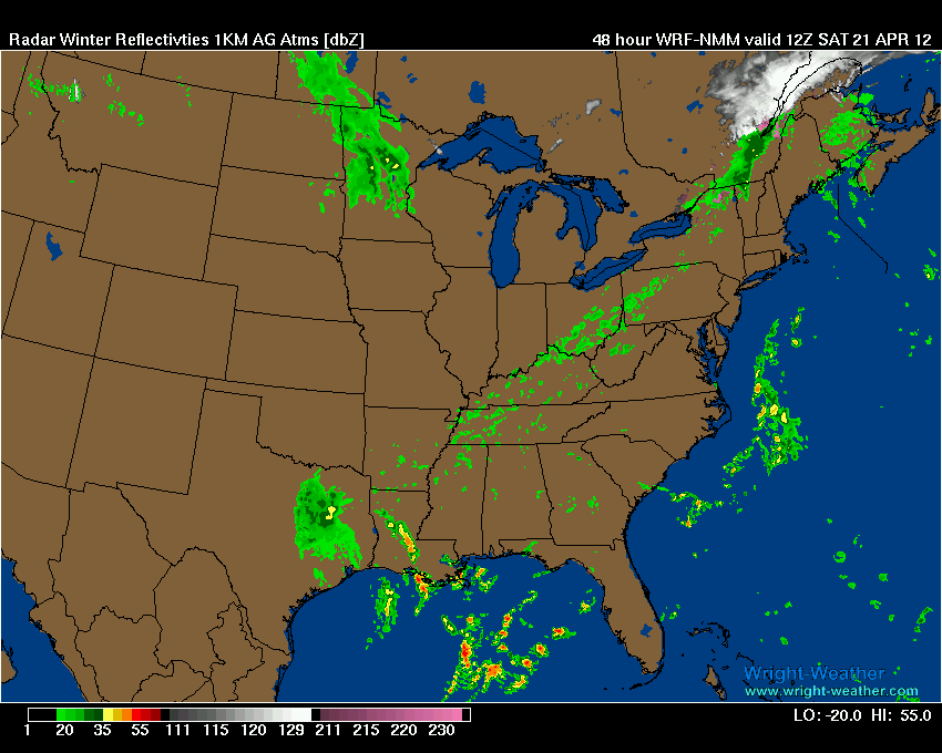
HEADLINES: The main concern over the coming days will be a cold front that will push into the region from the west/northwest on Friday and Friday night. Along and behind this front will be a band of showers. I can't rule out a rumble of thunder.
No severe weather is anticipated but some rumbles of thunder will be possible.
Here are two images from the high-res WRF - images from www.wright-weather.com - you can see that the first map shows the area of showers and thunderstorms moving in on Friday then the second map is Saturday morning (just a few showers left-over). I believe most of Saturday will end up dry.


Our unusual streak of severe weather free days will continue. April has been extremely quiet. I am sure we are all thankful for that - especially after the late February and early March outbreaks.
We could use some rain - drought monitor maps are starting to indicate that we are dry in the region. I have recorded about 1/2" of rain - so far this month. This comes after a fairly dry March. Concerns about drought are warranted.
If you remember we were supposed to have a wet spring - so much for that! This is why I tell everyone to take long range forecasting with a grain of salt. There is very little in the way of accuracy when it comes to seasonal forecasting. I have yet to find a meteorologist who could consistently forecast long range.
Here are a few drought maps - the first two are the Palmer Drought Index maps - the second two maps are precipitation anomaly maps.
If we don't start getting some rain then the map below will show the drought expanding in future updates.


 Here are the official 6 to 10 day outlook and the 8 to 14 day outlook - overall it appears like we may experience below normal precipitation. We will see how it goes. I do see a couple of chances of rain over the next 2-3 weeks. Will it be enough - that is the question.


Let's take a look at temperatures for the next few days - Friday will bring clouds but seasonable temperatures and then a bit cooler on Saturday.
First map is the Friday morning low temperatures - then Friday high temperatures - then Saturday morning lows and finally Saturday high temperatures


We have a TON of new weather maps on the Weather Observatory web-site - these include temperatures, wind speed, dew points, heat index, barometric pressure, predicted rainfall, climate forecast, medium and long range maps, forecasts and more! Click here
.
HEADLINES: The main concern over the coming days will be a cold front that will push into the region from the west/northwest on Friday and Friday night. Along and behind this front will be a band of showers. I can't rule out a rumble of thunder.
No severe weather is anticipated but some rumbles of thunder will be possible.
Here are two images from the high-res WRF - images from www.wright-weather.com - you can see that the first map shows the area of showers and thunderstorms moving in on Friday then the second map is Saturday morning (just a few showers left-over). I believe most of Saturday will end up dry.

Our unusual streak of severe weather free days will continue. April has been extremely quiet. I am sure we are all thankful for that - especially after the late February and early March outbreaks.
We could use some rain - drought monitor maps are starting to indicate that we are dry in the region. I have recorded about 1/2" of rain - so far this month. This comes after a fairly dry March. Concerns about drought are warranted.
If you remember we were supposed to have a wet spring - so much for that! This is why I tell everyone to take long range forecasting with a grain of salt. There is very little in the way of accuracy when it comes to seasonal forecasting. I have yet to find a meteorologist who could consistently forecast long range.
Here are a few drought maps - the first two are the Palmer Drought Index maps - the second two maps are precipitation anomaly maps.
If we don't start getting some rain then the map below will show the drought expanding in future updates.
Let's take a look at temperatures for the next few days - Friday will bring clouds but seasonable temperatures and then a bit cooler on Saturday.
First map is the Friday morning low temperatures - then Friday high temperatures - then Saturday morning lows and finally Saturday high temperatures
We have a TON of new weather maps on the Weather Observatory web-site - these include temperatures, wind speed, dew points, heat index, barometric pressure, predicted rainfall, climate forecast, medium and long range maps, forecasts and more! Click here
.
 .
.
We have a number of new radars available on our Weather Observatory web-site!
---
We now offer St Louis, Mt Vernon, Evansville, Poplar Bluff, Cape Girardeau, Marion, Paducah, Hopkinsville, and Dyersburg Interactive City Radars. We also have the two regional radars and now offer you three GR Earth radars.
Click here for our radar page - WEATHER RADARS---
---
We also have a new interactive radar - you can view that radar by clicking here.
. We have a number of new radars available on our Weather Observatory web-site!
---
We now offer St Louis, Mt Vernon, Evansville, Poplar Bluff, Cape Girardeau, Marion, Paducah, Hopkinsville, and Dyersburg Interactive City Radars. We also have the two regional radars and now offer you three GR Earth radars.
Click here for our radar page - WEATHER RADARS---
---
We also have a new interactive radar - you can view that radar by clicking here.
.
Want to learn more about how to use our radars? I made a how to video with more information
Click here - http://www.youtube.com/watch?v=bfLa0hI3adU
.
.
-----------------------------
.

.
Let's check out the how much rain is forecast to fall over the next 72 hours. This map gives you a general broad brushed idea of what can be expected. Remember the scale is at the top of the map.
.
If you would like to view the most up to date 24, 48, 72, and 120 hour precipitation forecast maps then click here.
Here is the rainfall forecast - again broad brushed - some areas may pick up very little in the way of rain.

.
If you would like to view the most up to date 24, 48, 72, and 120 hour precipitation forecast maps then click here.
Here is the rainfall forecast - again broad brushed - some areas may pick up very little in the way of rain.
.
.

.
You can also now view the probability of X amount of rain (you pick the value on the web-site) in a six hour period of time. Those maps can be viewed here.
.
You can view drought maps on the Weather Observatory web-site by clicking here.
.

Current conditions - including temperatures, apparent temperatures, heat index, wind chill, wind, pressure, humidity, dew points, and more - click here
.
You can also now view the probability of X amount of rain (you pick the value on the web-site) in a six hour period of time. Those maps can be viewed here.
.
You can view drought maps on the Weather Observatory web-site by clicking here.
.
Current conditions - including temperatures, apparent temperatures, heat index, wind chill, wind, pressure, humidity, dew points, and more - click here
.

.
You can view the upcoming days high temperature and low temperature forecasts by clicking here - choose the day - click on your state to zoom in
.
To view recent records that have been broken - click here
.
.
You can view the upcoming days high temperature and low temperature forecasts by clicking here - choose the day - click on your state to zoom in
.
To view recent records that have been broken - click here
.
.
---

.
Date Range: April 17th-30th
Event: Unsettled weather - several cold frontal passages Possible cool/cold air shots, as well.
Severe Risk: Small chances
Frozen Precipitation Risk: No
Details: Unsettled weather.
Confidence in my forecast. Medium
Date Range: May 5th-11h
Event: Unsettled weather
Severe Risk: Possible
Frozen Precipitation Risk: No
Details: Unsettled weather.
Confidence in my forecast. Low
.
Date Range: May 29th-June 3rd
Event: A larger scale system to impact the central United States
Severe Risk: Yes - possible event.
Details: Unsettled weather.
Confidence in my forecast. Low
Details: long range cycle forecast indicates the potential of a larger scale event during these dates.
Confidence in my forecast. Low More information on the long range cycle . .
.
Remember that as a general policy, in the long range outlook, I try not to mention severe thunderstorms more than 72 hours in advance (unless the signal is so overwhelmingly convincing that it warrants a mention). I will mention thunderstorm risks and I will give as many details as possible. Also remember you can view the long range severe weather outlooks by visiting the Storm Prediction Center's web-site - click here
.
-----------------------------
.
1. Nothing significant to comment about on the long range - our streak of below normal severe weather may continue for awhile - also several shots of cool air will be possible into the first part of May.
Now is a GREAT time to buy a NOAA All Hazards Weather Radio. Better to have one before storms strike than to be without one during an event. I recommend the Midland Model 300 NOAA All Hazards Weather Radio - that is what I use here at my house!
.
Meteorologist Beau DodsonMcCracken County Office of Emergency Management
.
.
Beau Dodson Weather - Facebook
.

To view all watches and warnings in Illinois - Click Here
To view all watches and warnings in Kentucky - Click Here
To view all watches and warnings in Missouri - Click Here
To view all watches and warnings in Tennessee - Click Here
.
All other states- Click Here
.
For the latest watches and warnings please visit your local National Weather Service Office web-site.
http://www.weather.gov/organization.php
.
Remember most of the maps on the blog can be viewed on Weather Observatory Web-Site
.

.
No comments:
Post a Comment