Saturday evening into Sunday update
For more frequent updates check visit my weather Facebook page - click here and hit like at the top of the page.

This blog is best viewed with Mozilla Firefox. There could be issues with spacing on Internet Explorer

.
Here are my current personal forecast thoughts for far southern Illinois and western Kentucky...
.
Rest of this afternoon (Saturday): Scattered showers and thunderstorms - some storms could be severe. The best chance for storms will be over the NORTHERN half of the region - less chance as you move south. Latest watches and warnings - click here
Highs: in the upper 70s and lower 80s - Wind: South winds at 5-10 mph.
Precipitation probability - 60% | Rainfall totals: 0.25" - locally higher amounts in thunderstorms
Confidence in this forecast is very high
Saturday night: Scattered showers and thunderstorms - some storms could be severe early in the evening. Mainly NORTHERN counties - not as concerned about southern counties. Latest watches and warnings - click here
Near normal temperatures
Lows: in the lower 60s - cooler over our northern counties | Normal lows for this time of the year are around 50 degrees.Near normal temperatures
Wind: Southwest winds at 5-10 mph.
Precipitation probability - 40% | Rainfall totals: 0.25" in areas that receive rain - locally higher
Confidence in this forecast is very high
.
Sunday: Partly cloudy with a few showers and thunderstorms. Again the main concern may be northern counties - southern counties may remain CAPPED - meaning storms can't form. Will monitor and update.
Near normal temperatures
Highs: around 75-80 degrees central/southern counties - a bit cooler over northern counties | Normal highs for this time of the year are around 73 degrees.Near normal temperatures
Wind: South winds at 5-10 mph
Precipitation probability - 40% | Rainfall totals: 0.25" with locally heavier amounts in thunderstorms Confidence in this forecast is high
Sunday night: Partly cloudy skies. Warm.
Above normal temperatures
Above normal temperatures
Lows: in the lower to middle 60s
temperatures will vary quite a bit over the region as a whole because of
the frontal system near our local counties | Normal lows for this time
of the year are around 50 degrees.
Wind: Southerly winds at 5-10 mph
Precipitation probability - 10% | Rainfall totals: 0.25"
Confidence in this forecast is medium
Wind: Southerly winds at 5-10 mph
Precipitation probability - 10% | Rainfall totals: 0.25"
Confidence in this forecast is medium
.
Monday: Partly cloudy - warm - a chance for thunderstorms - a few storms could be on the heavy side. Windy at times.
Above normal temperatures
Highs: around 75-80 degrees | Normal highs for this time of the year are around 73 degrees.Wind: Southwest at 10-15 mph - gusty at times
Precipitation probability - 40% | Rainfall totals: 0.25"-0.50" with locally heavier amounts in thunderstorms
Confidence in this forecast is medium
.
Don't forget to sign up for the severe weather "heads up" email list - I usually email everyone before a big event - severe weather - tornado outbreaks - winter storms - ice storms. Click here to join
.

.
.
Don't forget to sign up for the severe weather "heads up" email list - I usually email everyone before a big event - severe weather - tornado outbreaks - winter storms - ice storms. Click here to join
.
.

Thunderstorms are possible right on into the middle of next week. Some of these storms will produce heavy rain, lightning, very large hail, and high winds. Tornado threat is low but not zero.
Best chance for severe weather will be the northern half of the region. Less chances the further south you go in the area.
Some of the hail could be VERY large today. Mainly northern counties - monitor updates.
BOTTOM LINE - don't cancel any plans over the coming days - simply be weather aware and check the latest forecast and radars if you have outdoor plans!
.

Monitor radars if you have outdoor events. Thunderstorms will be possible. Mainly NORTHERN counties.
BOTTOM LINE - don't cancel any plans over the coming days - simply be weather aware and check the latest forecast and radars if you have outdoor plans!
.

The wild card in this forecast will be the timing of each precipitation event over the next few days. A frontal system will be close to our region and it will trigger occasional showers and thunderstorms. Some of the storms will be on the heavy side. Severe weather is also possible.
It will be difficult to pin-point what areas will pick up the heaviest rain - some areas will likely remain dry while neighboring areas pick up more than 1/2" of rain. Mainly northern and northwest counties - much of the region will remain dry.
It appears the best chance for the most widespread/heavy rain will be the northern half of our region.
.

.
No major changes in this update!
.

.
Forecast for your local town/city - Click Here
.
..
Join me on Facebook for more frequent updates on the weather in our local areaClick Here. I also strongly encourage you to FRIEND some of the local media meteorologists - I follow all of them and so should you.
.
---

The forecast for severe or extreme weather
.
The McCracken County Office of Emergency Management reminds you that owning a NOAA All Hazards Weather Radio is the best way to receive notifications of severe weather watches and warnings.
.
Remember that the National Weather Service defines a severe thunderstorm as one that produces 58 mph winds or higher, hail 1" in size or larger, and/or a tornado. More information with some slides concerning reporting severe weather - click here
.
For the most up to date severe weather outlooks - click here.
or
Visit the Storm Prediction Center's web-site - click here
.
Saturday night: A few storms could produce severe weather. Best chance will be the northern part of the region.
Saturday night: Will there be a chance for non-severe thunderstorms? Yes
.
.
Saturday night: A few storms could produce severe weather. Best chance will be the northern part of the region.
Saturday night: Will there be a chance for non-severe thunderstorms? Yes
.
Sunday: A few storms could produce severe weather. Again northern and northwest counties will be the main concern.
Sunday: Will there be a chance for non-severe thunderstorms? Yes
.Sunday: Will there be a chance for non-severe thunderstorms? Yes
Sunday night : Widespread severe weather is not anticipated. Monitor for updates.
Sunday night: Will there be a chance for non-severe thunderstorms? Yes
.
Monday: A few storms could produce severe weather.
Monday: Will there be a risk for non-severe thunderstorms? Yes
.
To view storm reports from today and yesterday - click here
.
.
 .
.
Will the Storm Prediction Center issue a tornado or severe thunderstorm watch for southeast Missouri, southern Illinois, or western Kentucky?
.
Tonight - Possible
Monday: Will there be a risk for non-severe thunderstorms? Yes
.
To view storm reports from today and yesterday - click here
.
.
Will the Storm Prediction Center issue a tornado or severe thunderstorm watch for southeast Missouri, southern Illinois, or western Kentucky?
.
Tonight - Possible
Sunday - Low chance - monitor - more likely north and northwest counties
Monday - Low chance - monitor
Tuesday - Low chance - monitor
.
To view the official Storm Prediction Center's web-site - click here Alternative link - click here
.
To view the official Storm Prediction Center's web-site - click here Alternative link - click here

.
To view all watches and warnings in IL - Click Here
To view all watches and warnings in KY - Click Here
To view all watches and warnings in MO - Click Here
To view all watches and warnings in TN - Click Here
All other states- Click Here
To view all watches and warnings in IL - Click Here
To view all watches and warnings in KY - Click Here
To view all watches and warnings in MO - Click Here
To view all watches and warnings in TN - Click Here
All other states- Click Here
.
The
links above are interactive and
you can move
around the United States by
simply clicking on the
national map - or
from the pull down menu
where it says regions and
US States.
.
To view the interactive warning map - click here.
.
.
 .
.
You can listen to local emergency services, SKYWARN storm spotters, and more by visiting our scanner feed page - click here
.
.
 .
.
The Weather Observatory is a strong partner with the National Weather Service - click here to visit your local NWS web-site. For the most up to date warnings/advisories hit refresh on their page.
.
To view the interactive warning map - click here.
.
.
You can listen to local emergency services, SKYWARN storm spotters, and more by visiting our scanner feed page - click here
.
.
The Weather Observatory is a strong partner with the National Weather Service - click here to visit your local NWS web-site. For the most up to date warnings/advisories hit refresh on their page.
.

This
forecast
analysis covers far southern
Illinois, southeast
Missouri,
southwest Indiana,
western Kentucky, and
northwest
Tennessee
.
HEADLINES: It is starting to feel like a broken record! A frontal system will remain draped in and near our region over the coming days. This means additional shower and thunderstorm chances.
.
HEADLINES: It is starting to feel like a broken record! A frontal system will remain draped in and near our region over the coming days. This means additional shower and thunderstorm chances.
There will be quite a bit of instability. This means that a few storms could become severe and produce hail, high winds, and heavy rain. Lightning is always a concern. An isolated tornado can not be ruled out - however, the tornado threat appears fairly low. Monitor for updates.
It appears the greatest chance for severe weather today - Saturday afternoon/evening will be over our northern counties - most likely from Bloomfield, MO to Madisonville, KY and then north of that line.
Severe storms could occur elsewhere - but it is not likely - appears that is the greatest risk zone. Almost every model I have looked at shows the most widespread activity north of that line.
Here is the official severe weather outlook for Saturday afternoon and evening. The orange area represents the slight risk zone - slight risk means a few severe thunderstorms are likely to occur but they should not be widespread in nature. The yellow area is the general thunderstorm risk zone (general thunderstorms mean they should remain below severe levels - although an isolated severe storm can occur in the yellow area, as well)

Best advice is simply to monitor radars from time to time.
Here are the temperature forecast maps for tonight and Sunday


We have a TON of new weather maps on
the Weather Observatory
web-site - these
include
temperatures,
wind speed, dew points,
heat
index, barometric
pressure,
predicted
rainfall, climate
forecast, medium and
long range maps,
forecasts and
more! Click here
.
 .
.
We have a number of new radars available on our Weather Observatory web-site!
---
We now offer St Louis, Mt Vernon, Evansville, Poplar Bluff, Cape Girardeau, Marion, Paducah, Hopkinsville, and Dyersburg Interactive City Radars. We also have the two regional radars and now offer you three GR Earth radars.
Click here for our radar page - WEATHER RADARS---
---
We also have a new interactive radar - you can view that radar by clicking here.
. We have a number of new radars available on our Weather Observatory web-site!
---
We now offer St Louis, Mt Vernon, Evansville, Poplar Bluff, Cape Girardeau, Marion, Paducah, Hopkinsville, and Dyersburg Interactive City Radars. We also have the two regional radars and now offer you three GR Earth radars.
Click here for our radar page - WEATHER RADARS---
---
We also have a new interactive radar - you can view that radar by clicking here.
.
Want to learn more about how to use our radars? I made a how to video with more information
Click here - http://www.youtube.com/watch?v=bfLa0hI3adU
.
.
-----------------------------
.

.
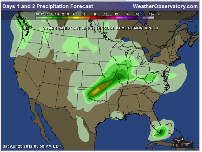
Let's
check
out the how much rain is
forecast to fall
over the next 48
hours. This map gives
you a general
broad brushed idea of
what can be
expected. Remember the scale is at the top of the map.
.
If you would like to view the most up to date 24, 48, 72, and 120 hour precipitation forecast maps then click here.
Notice that some areas WILL remain dry
.
If you would like to view the most up to date 24, 48, 72, and 120 hour precipitation forecast maps then click here.
Notice that some areas WILL remain dry
.

.
You can also now view the probability of X amount of rain (you pick the value on the web-site) in a six hour period of time. Those maps can be viewed here.
.
You can view drought maps on the Weather Observatory web-site by clicking here.
.

Current conditions - including temperatures, apparent temperatures, heat index, wind chill, wind, pressure, humidity, dew points, and more - click here
.
You can also now view the probability of X amount of rain (you pick the value on the web-site) in a six hour period of time. Those maps can be viewed here.
.
You can view drought maps on the Weather Observatory web-site by clicking here.
.
Current conditions - including temperatures, apparent temperatures, heat index, wind chill, wind, pressure, humidity, dew points, and more - click here
.

.
You can view the upcoming days high temperature and low temperature forecasts by clicking here - choose the day - click on your state to zoom in
.
To view recent records that have been broken - click here
.
.
You can view the upcoming days high temperature and low temperature forecasts by clicking here - choose the day - click on your state to zoom in
.
To view recent records that have been broken - click here
.
.
---

.
Date Range: April 17th-30th
Event: Unsettled weather - several cold frontal passages Possible cool/cold air shots, as well.
Severe Risk: Small chances
Frozen Precipitation Risk: No
Details: Unsettled weather.
Confidence in my forecast. Medium
Date Range: May 5th-11h
Event: Unsettled weather
Severe Risk: Possible
Frozen Precipitation Risk: No
Details: Unsettled weather.
Confidence in my forecast. Low
.
Date Range: May 29th-June 3rd
Event: A larger scale system to impact the central United States
Severe Risk: Yes - possible event.
Details: Unsettled weather.
Confidence in my forecast. Low
Details: long range cycle forecast indicates the potential of a larger scale event during these dates.
Confidence in my forecast. Low More information on the long range cycle
.
.
Remember that as a general policy, in the long range outlook, I try not to mention severe thunderstorms more than 72 hours in advance (unless the signal is so overwhelmingly convincing that it warrants a mention). I will mention thunderstorm risks and I will give as many details as possible. Also remember you can view the long range severe weather outlooks by visiting the Storm Prediction Center's web-site - click here
.
-----------------------------
.
1. The extended forecast looks
unsettled with a similar pattern continuing right on into next week -
several on/off rain chances - thunderstorm chances. Hopefully we all
start picking up some much needed rain.
.
Seasonal outlooks can be viewed on the web-site - click here
Seasonal outlooks can be viewed on the web-site - click here
Now is a GREAT
time to buy a NOAA All Hazards
Weather Radio. Better to have one
before storms
strike than to be without one
during an event. I recommend the
Midland Model 300 NOAA All Hazards Weather Radio - that is what I use here at my house!
.
Meteorologist Beau DodsonMcCracken County Office of Emergency Management
.
No comments:
Post a Comment