Friday through Tuesday update
I may update a bit more this weekend because of the cold front approaching
I am in summer mode - that means I try to update every other day or every 2-3 days. If the weather is active then I will come in and update the forecast as needed. I will also note an update at the very top of the blog update.
For more frequent updates check visit my weather Facebook page - click here and hit like at the top of the page.

This blog is best viewed with Mozilla Firefox. There could be issues with spacing on Internet Explorer
.

.
Here are my current personal forecast thoughts for far southern Illinois and western Kentucky...
Wind: West and southwest winds at 10 mph
Precipitation probability - 20% | Rainfall totals: isolated heavy rainfall totals in thunderstorms that manage to form in the heat of the day
Confidence in this forecast is very high
Friday: Very
hot and mostly dry - drought conditions. Isolated thunderstorms may pop
up during the afternoon heat - any storms that form can produce locally
heavy rain, hail, lightning, and gusty winds. An assortment of heat advisories,
special weather statements, and other information has been issued for
our region - for details click here
Above normal temperatures
Highs: in the 98-108 range | Normal highs for this time of the year are around 90 degrees.Above normal temperatures
Wind: West and southwest winds at 10 mph
Precipitation probability - 20% | Rainfall totals: isolated heavy rainfall totals in thunderstorms that manage to form in the heat of the day
Confidence in this forecast is very high
Friday night: Mostly
clear and warm. Just a small chance for some lingering storms.
Wind: Southwest winds at 5-10 mph
Precipitation probability - 10% | Rainfall totals: 0.25"-1.00" in areas that find themselves underneath storms - locally much higher totals possible
Confidence in this forecast is very high
Saturday: Partly sunny and very hot. Drought conditions. An isolated thunderstorm possible in the heat of the day - any storms that form can produce locally heavy rain, hail, lightning, and gusty winds. . An assortment of heat advisories, special weather statements, and other information has been issued for our region - for details click here
Above normal temperatures
Highs: in the 98-105 range | Normal highs for this time of the year are around 90 degrees.
Wind: Westerly at 5-15 mph
Precipitation probability - 20% | Rainfall totals: isolated very heavy rainfall totals in thunderstorms that manage to form in the heat of the day
Confidence in this forecast is very high
Wind: Southwest/westerly winds at 5-10 mph
Precipitation probability - 20% | Rainfall totals: 0.25" but locally heavier in thunderstorms
Confidence in this forecast is very high
Wind: Southwest winds at 5-15 mph
Precipitation probability - 40% | Rainfall totals: 0.25"-0.50" in areas that pick up a storm - also storms can produce locally heavier amounts
Confidence in this forecast is very high
.
Wind: Northerly winds at 10-15 mph
Precipitation probability - 70% | Rainfall totals - where rain occurs: 0.25"-0.50"
Confidence in this forecast is high
Monday night: Partly cloudy skies with a good chance for showers and thunderstorms.
Above normal temperatures
Lows: in the middle to upper 60s | Normal lows for this time of the year are around 69 degrees.
Wind: Northeast winds at 5-10 mph
Precipitation probability - 60% | Rainfall totals: 0.25"-0.50" keep in mind that thunderstorms can produce locally heavy rainfall totals
Confidence in this forecast is medium
Tuesday: Partly cloudy skies - a few thunderstorms possible - especially the southern half of the area.
Near normal temperatures
Highs: in the 82-86 degree range | Normal highs for this time of the year are around 90 degrees.
Wind: Northeast winds at 10-20 mph
Precipitation probability - 40% | Rainfall totals: 0.25" - keep in mind that thunderstorms can produce locally heavy rainfall totals
Confidence in this forecast is medium
Tuesday night: Partly cloudy skies - cooler
Near normal temperatures
Lows: in the middle 60s | Normal lows for this time of the year are around 69 degrees.
Wind: Northerly winds at 5-10 mph
Precipitation probability - less than 10% | Rainfall totals: 0"
Confidence in this forecast is medium
Wednesday: Mostly sunny skies and not as warm.
Near normal temperatures
Highs: in the middle to upper 80s | Normal highs for this time of the year are around 90 degrees.
Wind: Northeast winds at 5-10 mph
Precipitation probability - less than 10% | Rainfall totals: 0"
Confidence in this forecast is medium
Don't forget to sign up for the severe weather "heads up" email list - I usually email everyone before a big event - severe weather - tornado outbreaks - winter storms - ice storms. Click here to join
.

.
Above normal temperatures
Lows: in the middle to upper 70s | Normal lows for this time of the year are around 69 degrees.Wind: Southwest winds at 5-10 mph
Precipitation probability - 10% | Rainfall totals: 0.25"-1.00" in areas that find themselves underneath storms - locally much higher totals possible
Confidence in this forecast is very high
Saturday: Partly sunny and very hot. Drought conditions. An isolated thunderstorm possible in the heat of the day - any storms that form can produce locally heavy rain, hail, lightning, and gusty winds. . An assortment of heat advisories, special weather statements, and other information has been issued for our region - for details click here
Above normal temperatures
Highs: in the 98-105 range | Normal highs for this time of the year are around 90 degrees.
Wind: Westerly at 5-15 mph
Precipitation probability - 20% | Rainfall totals: isolated very heavy rainfall totals in thunderstorms that manage to form in the heat of the day
Confidence in this forecast is very high
Saturday night: Partly cloudy and warm A chance for a few showers and thunderstorms.
Above normal temperatures
Lows: in the middle to upper 70s | Normal lows for this time of the year are around 69 degrees.Wind: Southwest/westerly winds at 5-10 mph
Precipitation probability - 20% | Rainfall totals: 0.25" but locally heavier in thunderstorms
Confidence in this forecast is very high
.
Sunday: Partly sunny - hot - drought conditions. Thunderstorms possible - some heavy - any storms that form can produce locally
heavy rain, hail, lightning, and gusty winds. An assortment of heat advisories,
special weather statements, and other information has been issued for
our region - for details click here
Above normal temperatures
Highs: in the middle to upper 90s | Normal highs for this time of the year are around 90 degrees.Above normal temperatures
Wind: Southwest winds at 5-15 mph
Precipitation probability - 40% | Rainfall totals: 0.25"-0.50" in areas that pick up a storm - also storms can produce locally heavier amounts
Confidence in this forecast is very high
.
Sunday night: Increasing clouds - a good chance for heavy thunderstorms.
Above normal temperatures
Above normal temperatures
Lows: in the middle 70s | Normal lows for this time of the year are around 69 degrees.
Wind: Northerly winds of 5-10 mph
Precipitation probability - 70% | Rainfall totals - where rain occurs: 0.25"-0.50" with some higher amounts in thunderstorms
Confidence in this forecast is high
Wind: Northerly winds of 5-10 mph
Precipitation probability - 70% | Rainfall totals - where rain occurs: 0.25"-0.50" with some higher amounts in thunderstorms
Confidence in this forecast is high
Monday: Partly sunny and not as warm - a good chance for heavy thunderstorms.
Above normal temperatures
Highs: mostly in the 84-88 degree range | Normal
highs for this time of the year are around 90 degrees.Above normal temperatures
Wind: Northerly winds at 10-15 mph
Precipitation probability - 70% | Rainfall totals - where rain occurs: 0.25"-0.50"
Monday night: Partly cloudy skies with a good chance for showers and thunderstorms.
Above normal temperatures
Lows: in the middle to upper 60s | Normal lows for this time of the year are around 69 degrees.
Wind: Northeast winds at 5-10 mph
Precipitation probability - 60% | Rainfall totals: 0.25"-0.50" keep in mind that thunderstorms can produce locally heavy rainfall totals
Confidence in this forecast is medium
Tuesday: Partly cloudy skies - a few thunderstorms possible - especially the southern half of the area.
Near normal temperatures
Highs: in the 82-86 degree range | Normal highs for this time of the year are around 90 degrees.
Wind: Northeast winds at 10-20 mph
Precipitation probability - 40% | Rainfall totals: 0.25" - keep in mind that thunderstorms can produce locally heavy rainfall totals
Confidence in this forecast is medium
Tuesday night: Partly cloudy skies - cooler
Near normal temperatures
Lows: in the middle 60s | Normal lows for this time of the year are around 69 degrees.
Wind: Northerly winds at 5-10 mph
Precipitation probability - less than 10% | Rainfall totals: 0"
Confidence in this forecast is medium
Wednesday: Mostly sunny skies and not as warm.
Near normal temperatures
Highs: in the middle to upper 80s | Normal highs for this time of the year are around 90 degrees.
Wind: Northeast winds at 5-10 mph
Precipitation probability - less than 10% | Rainfall totals: 0"
Confidence in this forecast is medium
Don't forget to sign up for the severe weather "heads up" email list - I usually email everyone before a big event - severe weather - tornado outbreaks - winter storms - ice storms. Click here to join
.
.

Intense heat and drought over the region. Hot temperatures will be cause for concern
Please keep the heat in mind when planning outdoor activities - follow the basic/commonsense heat safety rules.
Elevated wildfire danger continues all week
Thunderstorm chances will continue into early next week - the best chance for rain will be Sunday into Monday night/Tuesday - this will be along a cold front. Otherwise, scattered afternoon storms will be possible each day. Some of the storms will produce frequent lightning, gusty winds, and hail. Brief heavy rain, as well.
I am posting information about the drought on the weather Facebook page - click here and hit like at the top of the page.
.

Basic heat precautions. Use care in the coming days - check on elderly residents.
Hottest part of the day will likely be from 1 pm through 6 pm. The 11 am through 7 pm will be very warm to hot - but the most intense heat is typically 1 pm through 6 pm.
Monitor radars for any storms that pop up- remember that a few storms will be severe with hail and high winds (very isolated reports). Flash flooding possible in isolated areas, as well. Many areas will remain dry. Better shot at widespread rain on Sunday into Monday night - prob most likely on Sunday night into Monday night.

Timing of the frontal passage on Monday/Tuesday is still a bit uncertain - speed of the front, as well
.
.

.
No major changes
.

.
Forecast for your local town/city - Click Here
.
..
Join me on Facebook for more frequent updates on the weather in our local areaClick Here. I also strongly encourage you to FRIEND some of the local media meteorologists - I follow all of them and so should you.
.
---

The forecast for severe or extreme weather
.
The McCracken County Office of Emergency Management reminds you that owning a NOAA All Hazards Weather Radio is the best way to receive notifications of severe weather watches and warnings.
.
Remember that the National Weather Service defines a severe thunderstorm as one that produces 58 mph winds or higher, hail 1" in size or larger, and/or a tornado. More information with some slides concerning reporting severe weather - click here
Friday: Very isolated severe storm possible - risk is low.
Friday: Will there be a chance for non-severe thunderstorms? Yes a few isolated storms scattered around the area
Friday night: Widespread severe weather is not anticipated. No snow or ice.
Friday night: Will there be a chance for non-severe thunderstorms? Yes a few isolated storms scattered around the area
Saturday: Very isolated severe storm can't be ruled out.
Saturday: Will there be a chance for non-severe thunderstorms? Yes a few isolated storms scattered around the area
.
Saturday night : Widespread severe weather is not anticipated. No snow or ice.
Saturday night: Will there be a chance for non-severe thunderstorms? Yes - isolated
.
Sunday: Isolated severe storm can't be ruled out.
Sunday: Will there be a risk for non-severe thunderstorms? Yes
Sunday night : Isolated severe storms can't be ruled out.
Sunday night: Will there be a chance for non-severe thunderstorms? Yes
Monday: A few storms may be severe.
Monday: Will there be a risk for non-severe thunderstorms? Yes
Monday night: A few storms may be severe.
Monday night: Will there be a chance for non-severe thunderstorms? Yes
Tuesday: Severe weather is not anticipated. No snow or ice.
Tuesday: Will there be a risk for non-severe thunderstorms? Yes - a few storms will still be possible
.
For the most up to date severe weather outlooks - click here.
or
Visit the Storm Prediction Center's web-site - click here
To view storm reports from today and yesterday - click here
.
 .
.
Will the Storm Prediction Center issue a tornado or severe thunderstorm watch for southeast Missouri, southern Illinois, or western Kentucky?
Friday - No
Saturday -No
Sunday - No
Sunday night - Very low chance (less than a 5% chance)
Monday - Very low chance (less than a 5% chance)
Monday night - Very low chance (less than a 5% chance)
Tuesday - No
Wednesday - No
Thursday - No
To view the official Storm Prediction Center's web-site - click here Alternative link - click here
To view storm reports from today and yesterday - click here
.
Will the Storm Prediction Center issue a tornado or severe thunderstorm watch for southeast Missouri, southern Illinois, or western Kentucky?
Friday - No
Saturday -No
Sunday - No
Sunday night - Very low chance (less than a 5% chance)
Monday - Very low chance (less than a 5% chance)
Monday night - Very low chance (less than a 5% chance)
Tuesday - No
Wednesday - No
Thursday - No
To view the official Storm Prediction Center's web-site - click here Alternative link - click here

.
To view all watches and warnings in IL - Click Here
To view all watches and warnings in KY - Click Here
To view all watches and warnings in MO - Click Here
To view all watches and warnings in TN - Click Here
All other states- Click Here
To view all watches and warnings in IL - Click Here
To view all watches and warnings in KY - Click Here
To view all watches and warnings in MO - Click Here
To view all watches and warnings in TN - Click Here
All other states- Click Here
.
The
links above are interactive and
you can move
around the United States by
simply clicking on the
national map - or
from the pull down menu
where it says regions and
US States.
.
To view the interactive warning map - click here.
.
 .
.
You can listen to local emergency services, SKYWARN storm spotters, and more by visiting our scanner feed page - click here
.
 .
.
The Weather Observatory is a strong partner with the National Weather Service - click here to visit your local NWS web-site. For the most up to date warnings/advisories hit refresh on their page.
.
To view the interactive warning map - click here.
.
You can listen to local emergency services, SKYWARN storm spotters, and more by visiting our scanner feed page - click here
.
The Weather Observatory is a strong partner with the National Weather Service - click here to visit your local NWS web-site. For the most up to date warnings/advisories hit refresh on their page.
.

This
forecast
analysis covers far southern
Illinois, southeast
Missouri,
southwest Indiana,
western Kentucky, and
northwest
Tennessee
.
HEADLINES: Tired of summer yet? No doubt many of you are wondering who turned the oven on. It has been extremely hot in our region with temperatures averaging 10-15 degrees above normal on most afternoons. That equals temperatures in the 98-105 range - pockets of 105-110 have been observed, as well - over the past week.
I do have better news - a break in the heat is heading our way. A cold front will approach and move into the area on Sunday (July 8th) into Monday night/Tuesday. The front is forecast to push through the area completely by Tuesday night - it may stall just to our south or near our region on Tuesday/Wednesday.
Before we get to next weeks weather - let's go ahead and look at the graphics for the highs on Friday (July 6) through next Wednesday - you can see things will moderate as we push into next week - temperatures could be even a little lower than these maps show (we will see - the dry ground conditions aren't helping us with cooling down).


Okay - now let's take a look ahead as far as the cold front later this weekend into early next week...
What does the front mean for sensible weather conditions? It means cooler temperatures - it means a chance for rain. Now - before you get overly excited by the word "cooler" - let me say that temperatures will end up more seasonable. Seasonable temperatures for this time of the year are in the 88-91 degree range. But - who is going to complain about those temperatures after what we just went through? Hopefully nobody. And, if we are lucky, temperatures will be even a little lower on a few days.
As far as precipitation chances - there will be scattered showers and heavy thunderstorms Friday into Sunday - again -same as the last few days. The cold front should bring a more organized chance for showers and thunderstorms on Sunday into Monday night and perhaps Tuesday. I am not saying everyone will see rain - but better chances than the last few weeks. We will hope for the best. At this point a lot of the crop damage is already done. Still - we have to start picking up regular rains to replenish the rivers, streams, lakes, and ponds.

We will have to suffer through a few more days of heat. Friday will bring highs in the upper 90s and lower 100s - Saturday and Sunday will bring the same. Expect more records to fall over the coming 3 day period. Please follow the common-sense heat safety rules. Read more about heat safety by clicking here.
By Monday and Tuesday temperatures will have started to fall a bit. I suspect many people will enjoy Tuesday and Wednesdays weather of next week - perhaps even into Thursday and Friday (we shall see).
The next question becomes - how long does the seasonable temperatures last? That is a great question. Typically during severe drought we see several heat waves. I have looked through over 120 years of weather records and I can tell you that when we have one long streak of 100 degree weather that we typically have one or two more streaks of 100 degree weather. So - expect more heat to come (I mean it is summer after-all). It does appear that most of next week will feature seasonable temperatures - I will then be watching for a rebound after that time period.
Let's take a look at some brand new maps - just updated. This will give you an idea of where this drought currently ranks. I have pulled up some historic maps to compare, as well.
First let's take a look at the last few months - this is the Palmer Drought Severity Index. The Palmer Drought maps are used by meteorologists to measure drought conditions.
The first map is March of 2012 - then April - May - and finally June. You can see how this drought has grown and progressed over the last few months.


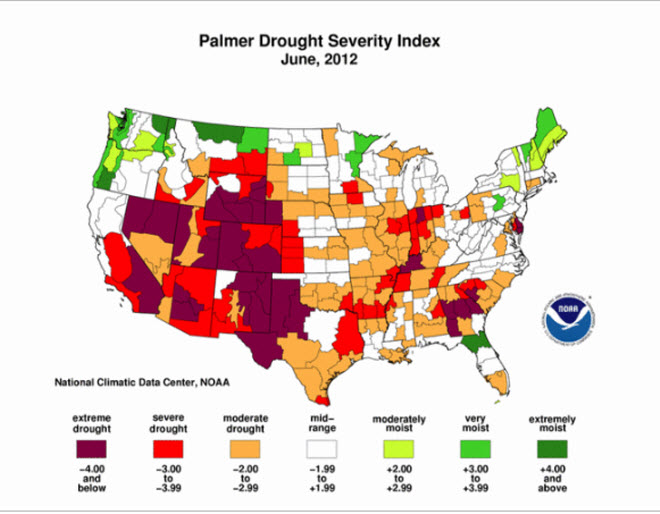 Just look at how large the drought is - it covers a large chunk of the nation.
Now let's take a look at some historic droughts in our region - let's compare the PDSI map below - June 2012 - to some other years.
First map - June of 2012 (current map)
 This next map is the June of 1931 map (below) - many of you already know that the 1930s brought severe drought to our region. You can see, on the map below, just how bad the drought was. The maroon color is the most intense drought area - then the red - then the orange is lesser drought. Maroon is considered extreme drought (see the color scale below each image).

Now let's take a look at June of 1934 (below) - another drought year. Look at the size and scope of the maroon colors. Impressive dust bowl year.
 Now let's take a look at June of 1936 (below)
 Next we take a look at the drought of 1954 and 1956 - see a pattern on droughts? The 1930s were drought years - the 1950s brought drought years.


And many of you remember the Drought of 1988 - the map below is from June of 1988
 We are certainly in an extreme weather pattern over the last 10 years - not much different than the 1930s and 1950s. Both of those decades brought a lot of extreme weather conditions.
NOAA has updated the drought forecast map - not promising for our region. It shows the drought at least persisting if not intensifying. Not good news.

Here are some more maps showing you the intensity and coverage of the ongoing drought.
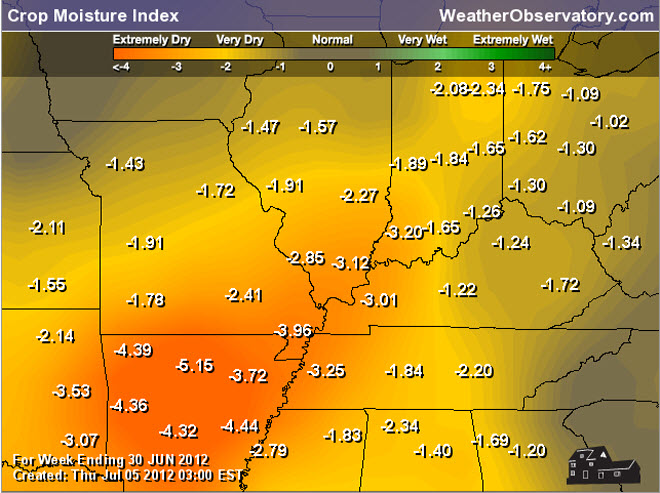
Notice map 2 and 3 - how much precipitation is needed to end the drought. That is a lot of rain. It will take months for us to recover from the drought - once we start to recover.


Let's take a look at some more maps - these maps are from NOAA. They are showing how much of the nation (during the Month of May) were very wet or very dry. I have labeled the Drought of 1988 and this years drought. You can see that much of the nation is DRY.

Now lets look at the January through June 2012 mean temperature departure map - check out how much of the nation has been above normal. A very warm year - thus far. Notice that Alaska was colder than normal - they had a brutal winter. Temperatures in some areas of Alaska reached -60 degrees. Brrrrr!


And if you thought there was a smokey look to the sky - the above map shows you the extent of thun smoke from the forest fires out west. The green area is light smoke - it does cover our region and much of the eastern half of the United States.
There have been thousands of records broken over the last few weeks/months - many of them heat records.
Some additional information here
Couple of comments from that site - below


We have a TON of new weather maps on the Weather Observatory web-site - these include temperatures, wind speed, dew points, heat index, barometric pressure, predicted rainfall, climate forecast, medium and long range maps, forecasts and more! Click here
.
HEADLINES: Tired of summer yet? No doubt many of you are wondering who turned the oven on. It has been extremely hot in our region with temperatures averaging 10-15 degrees above normal on most afternoons. That equals temperatures in the 98-105 range - pockets of 105-110 have been observed, as well - over the past week.
I do have better news - a break in the heat is heading our way. A cold front will approach and move into the area on Sunday (July 8th) into Monday night/Tuesday. The front is forecast to push through the area completely by Tuesday night - it may stall just to our south or near our region on Tuesday/Wednesday.
Before we get to next weeks weather - let's go ahead and look at the graphics for the highs on Friday (July 6) through next Wednesday - you can see things will moderate as we push into next week - temperatures could be even a little lower than these maps show (we will see - the dry ground conditions aren't helping us with cooling down).
Okay - now let's take a look ahead as far as the cold front later this weekend into early next week...
What does the front mean for sensible weather conditions? It means cooler temperatures - it means a chance for rain. Now - before you get overly excited by the word "cooler" - let me say that temperatures will end up more seasonable. Seasonable temperatures for this time of the year are in the 88-91 degree range. But - who is going to complain about those temperatures after what we just went through? Hopefully nobody. And, if we are lucky, temperatures will be even a little lower on a few days.
As far as precipitation chances - there will be scattered showers and heavy thunderstorms Friday into Sunday - again -same as the last few days. The cold front should bring a more organized chance for showers and thunderstorms on Sunday into Monday night and perhaps Tuesday. I am not saying everyone will see rain - but better chances than the last few weeks. We will hope for the best. At this point a lot of the crop damage is already done. Still - we have to start picking up regular rains to replenish the rivers, streams, lakes, and ponds.
We will have to suffer through a few more days of heat. Friday will bring highs in the upper 90s and lower 100s - Saturday and Sunday will bring the same. Expect more records to fall over the coming 3 day period. Please follow the common-sense heat safety rules. Read more about heat safety by clicking here.
By Monday and Tuesday temperatures will have started to fall a bit. I suspect many people will enjoy Tuesday and Wednesdays weather of next week - perhaps even into Thursday and Friday (we shall see).
The next question becomes - how long does the seasonable temperatures last? That is a great question. Typically during severe drought we see several heat waves. I have looked through over 120 years of weather records and I can tell you that when we have one long streak of 100 degree weather that we typically have one or two more streaks of 100 degree weather. So - expect more heat to come (I mean it is summer after-all). It does appear that most of next week will feature seasonable temperatures - I will then be watching for a rebound after that time period.
Let's take a look at some brand new maps - just updated. This will give you an idea of where this drought currently ranks. I have pulled up some historic maps to compare, as well.
First let's take a look at the last few months - this is the Palmer Drought Severity Index. The Palmer Drought maps are used by meteorologists to measure drought conditions.
The first map is March of 2012 - then April - May - and finally June. You can see how this drought has grown and progressed over the last few months.
Now let's take a look at some historic droughts in our region - let's compare the PDSI map below - June 2012 - to some other years.
First map - June of 2012 (current map)
Now let's take a look at June of 1934 (below) - another drought year. Look at the size and scope of the maroon colors. Impressive dust bowl year.
And many of you remember the Drought of 1988 - the map below is from June of 1988
NOAA has updated the drought forecast map - not promising for our region. It shows the drought at least persisting if not intensifying. Not good news.
Here are some more maps showing you the intensity and coverage of the ongoing drought.
Notice map 2 and 3 - how much precipitation is needed to end the drought. That is a lot of rain. It will take months for us to recover from the drought - once we start to recover.
Let's take a look at some more maps - these maps are from NOAA. They are showing how much of the nation (during the Month of May) were very wet or very dry. I have labeled the Drought of 1988 and this years drought. You can see that much of the nation is DRY.
Now lets look at the January through June 2012 mean temperature departure map - check out how much of the nation has been above normal. A very warm year - thus far. Notice that Alaska was colder than normal - they had a brutal winter. Temperatures in some areas of Alaska reached -60 degrees. Brrrrr!
And if you thought there was a smokey look to the sky - the above map shows you the extent of thun smoke from the forest fires out west. The green area is light smoke - it does cover our region and much of the eastern half of the United States.
There have been thousands of records broken over the last few weeks/months - many of them heat records.
Some additional information here
Couple of comments from that site - below
We have a TON of new weather maps on the Weather Observatory web-site - these include temperatures, wind speed, dew points, heat index, barometric pressure, predicted rainfall, climate forecast, medium and long range maps, forecasts and more! Click here
.
 .
.
We have a number of new radars available on our Weather Observatory web-site!
---
We now offer St Louis, Mt Vernon, Evansville, Poplar Bluff, Cape Girardeau, Marion, Paducah, Hopkinsville, and Dyersburg Interactive City Radars. We also have the two regional radars and now offer you three GR Earth radars.
Click here for our radar page - WEATHER RADARS---
---
We also have a new interactive radar - you can view that radar by clicking here.
. We have a number of new radars available on our Weather Observatory web-site!
---
We now offer St Louis, Mt Vernon, Evansville, Poplar Bluff, Cape Girardeau, Marion, Paducah, Hopkinsville, and Dyersburg Interactive City Radars. We also have the two regional radars and now offer you three GR Earth radars.
Click here for our radar page - WEATHER RADARS---
---
We also have a new interactive radar - you can view that radar by clicking here.
.
Want to learn more about how to use our radars? I made a how to video with more information
Click here - http://www.youtube.com/watch?v=bfLa0hI3adU
.
.
-----------------------------
.

.
Let's
check
out the how much rain is
forecast to fall
over the next 120
hours (5 days). This map gives
you a general
broad brushed idea of
what can be
expected. Remember the scale is at the top of the map.
.
If you would like to view the most up to date 24, 48, 72, and 120 hour precipitation forecast maps then click here.
.
If you would like to view the most up to date 24, 48, 72, and 120 hour precipitation forecast maps then click here.
.

.
You can also now view the probability of X amount of rain (you pick the value on the web-site) in a six hour period of time. Those maps can be viewed here.
.
You can view drought maps on the Weather Observatory web-site by clicking here.
.

Current conditions - including temperatures, apparent temperatures, heat index, wind chill, wind, pressure, humidity, dew points, and more - click here
.
You can also now view the probability of X amount of rain (you pick the value on the web-site) in a six hour period of time. Those maps can be viewed here.
.
You can view drought maps on the Weather Observatory web-site by clicking here.
.
Current conditions - including temperatures, apparent temperatures, heat index, wind chill, wind, pressure, humidity, dew points, and more - click here
.

.
You can view the upcoming days high temperature and low temperature forecasts by clicking here - choose the day - click on your state to zoom in
.
To view recent records that have been broken - click here
.
.
You can view the upcoming days high temperature and low temperature forecasts by clicking here - choose the day - click on your state to zoom in
.
To view recent records that have been broken - click here
.
.
---

.
.
.
Remember that as a general policy, in the long range outlook, I try not to mention severe thunderstorms more than 72 hours in advance (unless the signal is so overwhelmingly convincing that it warrants a mention). I will mention thunderstorm risks and I will give as many details as possible. Also remember you can view the long range severe weather outlooks by visiting the Storm Prediction Center's web-site - click here
.
-----------------------------
.
1. The latest 6-10 and 8-14 day temperature forecast maps are out - they show that we should head towards more seasonable levels next week. The dates of forecast for each map can be seen at the top of the image


DROUGHT INFORMATION - CLICK HERE
Seasonal outlooks can be viewed on the web-site - click here
DROUGHT INFORMATION - CLICK HERE
Seasonal outlooks can be viewed on the web-site - click here
Now is a GREAT
time to buy a NOAA All Hazards
Weather Radio. Better to have one
before storms
strike than to be without one
during an event. I recommend the
Midland Model 300 NOAA All Hazards Weather Radio - that is what I use here at my house!
.
Meteorologist Beau DodsonMcCracken County Office of Emergency Management
.
.
Beau Dodson Weather - Facebook
.

To view all watches and warnings in Illinois - Click Here
To view all watches and warnings in Kentucky - Click Here
To view all watches and warnings in Missouri - Click Here
To view all watches and warnings in Tennessee - Click Here
.
All other states- Click Here
.
For the latest watches and warnings please visit your local National Weather Service Office web-site.
http://www.weather.gov/organization.php
.
Remember most of the maps on the blog can be viewed on Weather Observatory Web-Site
.

.
No comments:
Post a Comment