Monday through Friday update
I am in summer mode - that means I try to update every other day or every 2-3 days. If the weather is active then I will come in and update the forecast as needed. I will also note an update at the very top of the blog update.
For more frequent updates check visit my weather Facebook page - click here and hit like at the top of the page.

This blog is best viewed with Mozilla Firefox. There could be issues with spacing on Internet Explorer
.

.
Here are my current personal forecast thoughts for far southern Illinois and western Kentucky...
Wind: Southwest 5-10 mph
Precipitation probability - 20% | Rainfall totals: 0.25-0.50" - thunderstorms can and often do produce heavier amounts.
Confidence in this forecast is very high
Monday: Partly cloudy - hot and humid - isolated thunderstorms
Above normal temperatures
Highs: in the lower to middle 90s | Normal highs for this time of the year are around 90 degrees.Above normal temperatures
Wind: Southwest 5-10 mph
Precipitation probability - 20% | Rainfall totals: 0.25-0.50" - thunderstorms can and often do produce heavier amounts.
Confidence in this forecast is very high
Monday night: Partly cloudy - warm and humid - isolated thunderstorms possible
Wind: Southerly winds at 5-10 mph
Precipitation probability - 20% | Rainfall totals: 0.25-0.50" thunderstorms can and often do produce heavier amounts.
Confidence in this forecast is very high
Tuesday: Partly cloudy - hot and humid - isolated thunderstorms possible
Wind: Southerly at 5-10 mph
Precipitation probability - 20% | Rainfall totals: 0.25-0.50" thunderstorms can and often do produce heavier amounts.
Confidence in this forecast is very high
Wind: Southerly winds at 5-10 mph
Precipitation probability - 20% | Rainfall totals: 0.25" thunderstorms can and often do produce heavier amounts.
Confidence in this forecast is very high
Wind: Southerly winds at 5-15 mph
Precipitation probability - 20% | Rainfall totals: 0.25" thunderstorms can and often do produce heavier amounts.
Confidence in this forecast is very high
.
Wind: Southerly winds at 5-10 mph
Precipitation probability - 40% | Rainfall totals: scattered 0.25" thunderstorms can and often do produce heavier amounts.
Confidence in this forecast is medium
Thursday night: Partly cloudy - warm and humid - isolated thunderstorms possible.
Above normal temperatures
Lows: in the 70s | Normal lows for this time of the year are around 69 degrees.
Wind: Southerly winds at 5 mph
Precipitation probability - 30% | Rainfall totals: scattered 0.25" thunderstorms can and often do produce heavier amounts.
Confidence in this forecast is medium
Friday: Partly cloudy - hot and humid - scattered thunderstorms
Above normal temperatures
Highs: in the lower to middle 90s | Normal highs for this time of the year are around 90 degrees.
Wind: Southerly winds at 5-10 mph
Precipitation probability - 30% | Rainfall totals: scattered 0.25" thunderstorms can and often do produce heavier amounts.
Confidence in this forecast is medium
Friday night: Partly cloudy - warm and humid - isolated thunderstorms possible.Above normal temperatures
Lows: in the 70s | Normal lows for this time of the year are around 69 degrees.
Wind: South winds at 5 mph
Precipitation probability - 20% | Rainfall totals: scattered 0.25" thunderstorms can and often do produce heavier amounts.
Confidence in this forecast is medium
Don't forget to sign up for the severe weather "heads up" email list - I usually email everyone before a big event - severe weather - tornado outbreaks - winter storms - ice storms. Click here to join
.

.
Above normal temperatures
Lows: in the 70s | Normal lows for this time of the year are around 69 degrees.Wind: Southerly winds at 5-10 mph
Precipitation probability - 20% | Rainfall totals: 0.25-0.50" thunderstorms can and often do produce heavier amounts.
Confidence in this forecast is very high
Tuesday: Partly cloudy - hot and humid - isolated thunderstorms possible
Above normal temperatures
Highs: in the middle 90s | Normal highs for this time of the year are around 90 degrees.Wind: Southerly at 5-10 mph
Precipitation probability - 20% | Rainfall totals: 0.25-0.50" thunderstorms can and often do produce heavier amounts.
Confidence in this forecast is very high
Tuesday night: Partly cloudy - warm and humid - isolated thunderstorms possible
Above normal temperatures
Lows: in the 70s | Normal lows for this time of the year are around 69 degrees.Wind: Southerly winds at 5-10 mph
Precipitation probability - 20% | Rainfall totals: 0.25" thunderstorms can and often do produce heavier amounts.
Confidence in this forecast is very high
.
Wednesday: Partly cloudy - hot and humid - isolated thunderstormsAbove normal temperatures
Highs: in the 92-95 degree range | Normal highs for this time of the year are around 90 degrees.Wind: Southerly winds at 5-15 mph
Precipitation probability - 20% | Rainfall totals: 0.25" thunderstorms can and often do produce heavier amounts.
Confidence in this forecast is very high
.
Wednesday night: Partly cloudy - warm and humid - scattered thunderstorms possible
Above normal temperatures
Above normal temperatures
Lows: in the 70s | Normal lows for this time of the year are around 69 degrees.
Wind: Southerly winds of 5-10 mph
Precipitation probability - 30% | Rainfall totals: 0.25" thunderstorms can and often do produce heavier amounts.
Confidence in this forecast is high
Wind: Southerly winds of 5-10 mph
Precipitation probability - 30% | Rainfall totals: 0.25" thunderstorms can and often do produce heavier amounts.
Confidence in this forecast is high
Thursday: Partly cloudy - hot and humid - scattered thunderstorms
Above normal temperatures
Highs: mostly in the lower 90s | Normal
highs for this time of the year are around 90 degrees.Above normal temperatures
Wind: Southerly winds at 5-10 mph
Precipitation probability - 40% | Rainfall totals: scattered 0.25" thunderstorms can and often do produce heavier amounts.
Thursday night: Partly cloudy - warm and humid - isolated thunderstorms possible.
Above normal temperatures
Lows: in the 70s | Normal lows for this time of the year are around 69 degrees.
Wind: Southerly winds at 5 mph
Precipitation probability - 30% | Rainfall totals: scattered 0.25" thunderstorms can and often do produce heavier amounts.
Confidence in this forecast is medium
Friday: Partly cloudy - hot and humid - scattered thunderstorms
Above normal temperatures
Highs: in the lower to middle 90s | Normal highs for this time of the year are around 90 degrees.
Wind: Southerly winds at 5-10 mph
Precipitation probability - 30% | Rainfall totals: scattered 0.25" thunderstorms can and often do produce heavier amounts.
Confidence in this forecast is medium
Friday night: Partly cloudy - warm and humid - isolated thunderstorms possible.Above normal temperatures
Lows: in the 70s | Normal lows for this time of the year are around 69 degrees.
Wind: South winds at 5 mph
Precipitation probability - 20% | Rainfall totals: scattered 0.25" thunderstorms can and often do produce heavier amounts.
Confidence in this forecast is medium
Don't forget to sign up for the severe weather "heads up" email list - I usually email everyone before a big event - severe weather - tornado outbreaks - winter storms - ice storms. Click here to join
.
.

The heat returns this week - actual air temperatures will be in the 90s and "feels like" temperatures will be 95-105 degrees. Hot and humid - typical summer weather for our region. Isolated to scattered thunderstorms will produce cloud to ground lightning, brief heavy rain, and gusty winds.
I am posting information about the drought on the weather Facebook page - click here and hit like at the top of the page.
.

Most likely no. If a thunderstorm forms then there will of course be a chance for brief heavy rain and lightning. A gust of wind is also possible.

No wild card in this update
.
.

.
No significant changes
.

.
Forecast for your local town/city - Click Here
.
..
Join me on Facebook for more frequent updates on the weather in our local areaClick Here. I also strongly encourage you to FRIEND some of the local media meteorologists - I follow all of them and so should you.
.
---

The forecast for severe or extreme weather
.
The McCracken County Office of Emergency Management reminds you that owning a NOAA All Hazards Weather Radio is the best way to receive notifications of severe weather watches and warnings.
.
Remember that the National Weather Service defines a severe thunderstorm as one that produces 58 mph winds or higher, hail 1" in size or larger, and/or a tornado. More information with some slides concerning reporting severe weather - click here
Monday: Widespread severe weather is not anticipated. No snow or ice.
Monday: Will there be a chance for non-severe thunderstorms? Yes
Monday night: Widespread severe weather is not anticipated. No snow or ice.
Monday night: Will there be a chance for non-severe thunderstorms? Yes isolated
Tuesday: Widespread severe weather is not anticipated. No snow or ice.
Tuesday: Will there be a chance for non-severe thunderstorms? Yes
.
Tuesday night : Widespread severe weather is not anticipated. No snow or ice.
Tuesday night: Will there be a chance for non-severe thunderstorms? Yes - isolated
.
Wednesday: Widespread severe weather is not anticipated. No snow or ice.
Wednesday: Will there be a risk for non-severe thunderstorms? Yes
Wednesday night : Widespread severe weather is not anticipated. No snow or ice.
Wednesday night: Will there be a chance for non-severe thunderstorms? Yes isolated
Thursday: Widespread severe weather is not anticipated. No snow or ice.
Thursday: Will there be a risk for non-severe thunderstorms? Yes
Thursday night: Widespread evere weather is not anticipated. No snow or ice.
Thursday night: Will there be a chance for non-severe thunderstorms? Yes isolated.
Friday: Widespread severe weather is not anticipated. No snow or ice.
Friday: Will there be a risk for non-severe thunderstorms? Yes
.
For the most up to date severe weather outlooks - click here.
or
Visit the Storm Prediction Center's web-site - click here
To view storm reports from today and yesterday - click here
.
 .
.
Will the Storm Prediction Center issue a tornado or severe thunderstorm watch for southeast Missouri, southern Illinois, or western Kentucky?
Monday - No
Tuesday - No
Wednesday - No
Thursday - No
Friday - No
Saturday - No
Sunday - No
To view the official Storm Prediction Center's web-site - click here Alternative link - click here
To view storm reports from today and yesterday - click here
.
Will the Storm Prediction Center issue a tornado or severe thunderstorm watch for southeast Missouri, southern Illinois, or western Kentucky?
Monday - No
Tuesday - No
Wednesday - No
Thursday - No
Friday - No
Saturday - No
Sunday - No
To view the official Storm Prediction Center's web-site - click here Alternative link - click here

.
To view all watches and warnings in IL - Click Here
To view all watches and warnings in KY - Click Here
To view all watches and warnings in MO - Click Here
To view all watches and warnings in TN - Click Here
All other states- Click Here
To view all watches and warnings in IL - Click Here
To view all watches and warnings in KY - Click Here
To view all watches and warnings in MO - Click Here
To view all watches and warnings in TN - Click Here
All other states- Click Here
.
The
links above are interactive and
you can move
around the United States by
simply clicking on the
national map - or
from the pull down menu
where it says regions and
US States.
.
To view the interactive warning map - click here.
.
 .
.
You can listen to local emergency services, SKYWARN storm spotters, and more by visiting our scanner feed page - click here
.
 .
.
The Weather Observatory is a strong partner with the National Weather Service - click here to visit your local NWS web-site. For the most up to date warnings/advisories hit refresh on their page.
.
To view the interactive warning map - click here.
.
You can listen to local emergency services, SKYWARN storm spotters, and more by visiting our scanner feed page - click here
.
The Weather Observatory is a strong partner with the National Weather Service - click here to visit your local NWS web-site. For the most up to date warnings/advisories hit refresh on their page.
.

This
forecast
analysis covers far southern
Illinois, southeast
Missouri,
southwest Indiana,
western Kentucky, and
northwest
Tennessee
.
HEADLINES: Greetings - things have been a little bit slow around here the last few days - that is thanks to a lightning strike during one of the thunderstorms last week. However, we are about to get everything back up and running.
It appears our summer heat will return this week - temperatures will rise into the 90s each day with heat index values in the 95-105 degree range. This will make conditions uncomfortable outside.
There will be a daily chance for scattered thunderstorms - perhaps isolated is a better word. Where a thunderstorm forms you will experience heavy downpours.
Portions of the region picked up anywhere from no rain last week to over 8 inches of rain! Truly this is feast or famine weather.
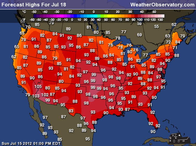
Let's take a look at the high temperature maps for the upcoming week - the center of the heat dome will be a bit to our west and northwest - that is where the 100-110 degree weather will most likely occur.


 Let's also take a look at some of the drought maps - the recent rainfall (in some areas) does not really put much of a dent in the severe drought we are experiencing.


No real relief in sight.
And for something a little different on the maps - let's take a look at the greenness maps - you can see that a large chunk of the nation has dry vegetation - drought. Click image for a larger view

We have a TON of new weather maps on
the Weather
Observatory
web-site - these include
temperatures, wind speed,
dew points, heat
index,
barometric
pressure, predicted
rainfall,
climate forecast, medium
and long
range maps,
forecasts and more! Click here
.
HEADLINES: Greetings - things have been a little bit slow around here the last few days - that is thanks to a lightning strike during one of the thunderstorms last week. However, we are about to get everything back up and running.
It appears our summer heat will return this week - temperatures will rise into the 90s each day with heat index values in the 95-105 degree range. This will make conditions uncomfortable outside.
There will be a daily chance for scattered thunderstorms - perhaps isolated is a better word. Where a thunderstorm forms you will experience heavy downpours.
Portions of the region picked up anywhere from no rain last week to over 8 inches of rain! Truly this is feast or famine weather.
Let's take a look at the high temperature maps for the upcoming week - the center of the heat dome will be a bit to our west and northwest - that is where the 100-110 degree weather will most likely occur.
No real relief in sight.
And for something a little different on the maps - let's take a look at the greenness maps - you can see that a large chunk of the nation has dry vegetation - drought. Click image for a larger view

.
 .
.
We have a number of new radars available on our Weather Observatory web-site!
---
We now offer St Louis, Mt Vernon, Evansville, Poplar Bluff, Cape Girardeau, Marion, Paducah, Hopkinsville, and Dyersburg Interactive City Radars. We also have the two regional radars and now offer you three GR Earth radars.
Click here for our radar page - WEATHER RADARS---
---
We also have a new interactive radar - you can view that radar by clicking here.
. We have a number of new radars available on our Weather Observatory web-site!
---
We now offer St Louis, Mt Vernon, Evansville, Poplar Bluff, Cape Girardeau, Marion, Paducah, Hopkinsville, and Dyersburg Interactive City Radars. We also have the two regional radars and now offer you three GR Earth radars.
Click here for our radar page - WEATHER RADARS---
---
We also have a new interactive radar - you can view that radar by clicking here.
.
Want to learn more about how to use our radars? I made a how to video with more information
Click here - http://www.youtube.com/watch?v=bfLa0hI3adU
.
.
-----------------------------
.

.
Let's
check
out the how much rain is
forecast to fall
over the next 120
hours (5 days). This map gives
you a general
broad brushed idea of
what can be
expected. Remember the scale is at the top of the map.
.
If you would like to view the most up to date 24, 48, 72, and 120 hour precipitation forecast maps then click here.
A widespread rain event is not in the forecast - however, scattered storms could produce pockets of locally heavy rainfall during the week.
.
If you would like to view the most up to date 24, 48, 72, and 120 hour precipitation forecast maps then click here.
A widespread rain event is not in the forecast - however, scattered storms could produce pockets of locally heavy rainfall during the week.
.

.
You can also now view the probability of X amount of rain (you pick the value on the web-site) in a six hour period of time. Those maps can be viewed here.
.
You can view drought maps on the Weather Observatory web-site by clicking here.
.

Current conditions - including temperatures, apparent temperatures, heat index, wind chill, wind, pressure, humidity, dew points, and more - click here
.
You can also now view the probability of X amount of rain (you pick the value on the web-site) in a six hour period of time. Those maps can be viewed here.
.
You can view drought maps on the Weather Observatory web-site by clicking here.
.
Current conditions - including temperatures, apparent temperatures, heat index, wind chill, wind, pressure, humidity, dew points, and more - click here
.

.
You can view the upcoming days high temperature and low temperature forecasts by clicking here - choose the day - click on your state to zoom in
.
To view recent records that have been broken - click here
.
.
You can view the upcoming days high temperature and low temperature forecasts by clicking here - choose the day - click on your state to zoom in
.
To view recent records that have been broken - click here
.
.
---

.
.
.
Remember that as a general policy, in the long range outlook, I try not to mention severe thunderstorms more than 72 hours in advance (unless the signal is so overwhelmingly convincing that it warrants a mention). I will mention thunderstorm risks and I will give as many details as possible. Also remember you can view the long range severe weather outlooks by visiting the Storm Prediction Center's web-site - click here
-----------------------------
.
1.
DROUGHT INFORMATION - CLICK HERE
Here are the latest 6-10 day temperature and 8-14 day temperature outlooks - see the date stamps at the top of each image

 And here is the latest 6-10 day precipitation and 8-14 day precipitation forecast maps - not good news


Seasonal outlooks can be viewed on the web-site - click here
If you are a weather enthusiast then I recommend listening to WeatherBrains each week! For a more in-depth look at what is happening in meteorology.

DROUGHT INFORMATION - CLICK HERE
Here are the latest 6-10 day temperature and 8-14 day temperature outlooks - see the date stamps at the top of each image
Seasonal outlooks can be viewed on the web-site - click here
If you are a weather enthusiast then I recommend listening to WeatherBrains each week! For a more in-depth look at what is happening in meteorology.
Now is a GREAT
time to buy a NOAA All Hazards
Weather Radio. Better to have one
before storms
strike than to be without one
during an event. I recommend the
Midland Model 300 NOAA All Hazards Weather Radio - that is what I use here at my house!
.
Meteorologist Beau DodsonMcCracken County Office of Emergency Management
.
.
Beau Dodson Weather - Facebook
.

To view all watches and warnings in Illinois - Click Here
To view all watches and warnings in Kentucky - Click Here
To view all watches and warnings in Missouri - Click Here
To view all watches and warnings in Tennessee - Click Here
.
All other states- Click Here
.
For the latest watches and warnings please visit your local National Weather Service Office web-site.
http://www.weather.gov/organization.php
.
Remember most of the maps on the blog can be viewed on Weather Observatory Web-Site
.

.
No comments:
Post a Comment