
This blog is best viewed with Mozilla Firefox. There could be issues with spacing on Internet Explorer

.
Here are my current personal forecast thoughts for far southern Illinois and western Kentucky...
Tuesday night: Cloudy with a few light rain showers possible.
Lows: in the middle to upper 30s Wind: West winds at 5 mph
Precipitation probability - 20% | Rainfall totals: 0.05"
Confidence in this forecast is very high
Wednesday: Some clouds - cool - a slight chance for a rain shower.
Highs: Mainly in the lower 50s
Wind: Northwest winds 5-10 mph
Precipitation probability - 10% | Rainfall totals: 0.10"
Confidence in this forecast is high
Forecast for your local town/city - Click Here
Wednesday night: Mostly clear and colder - patches of frost possible - fog possible - freezing fog on some bridges not out of the question.
Lows: in the upper 20s and lower 30s Wind: North winds at 5 mph
Precipitation probability - 0% | Rainfall totals: 0"
Confidence in this forecast is very high
.
Thursday: Foggy morning - then fog will mix out - becoming partly sunny and not quite as cool as recent days.
Highs: In the upper 50s Wind: South winds at 5 mph
Precipitation probability - 0% | Rainfall totals: 0"
Confidence in this forecast is high
Thursday night: Mostly clear and cool.
Lows: in the 35-40 degree range
Wind: Southeast winds at 5 mph
Precipitation probability - 0% | Rainfall totals: 0"
Confidence in this forecast is high
Friday Partly sunny and warmer.
Highs: in the middle 60s
Wind: Southeast winds at 10-20 mph
Precipitation probability - 0% | Rainfall totals: 0"
Confidence in this forecast is high
Forecast for your local town/city - Click Here

This
forecast
analysis covers far southern
Illinois, southeast
Missouri,
southwest Indiana,
western Kentucky, and
northwest
Tennessee
HEADLINES: Hello everyone! Hope you are ready for some "calm" weather? At least it will be calm for our region - areas of the Northeast will once again have to deal with yet another storm system. It will be a long/slow recovery for damaged areas along the coastline.
For our region - we will mostly be in-between storm systems. One exiting to the east, which could bring a few showers tonight (Tuesday night) and Wednesday morning and the other system well off to our west. Chances are small for rain at any given area tonight into Wednesday. Rainfall amounts would be on the light side.
We will start to warm up on Thursday and Friday - ahead of the next storm system. We may see temperatures near 70 on Saturday and Sunday. If it warms up this time of the year then you can expect rain or storms. That will be the case this time around.
A cold front will enter our area on Sunday night and Monday - showers and thunderstorm chances will increase dramatically with the front. It appears that a line of showers and thunderstorms will move from west to east across our region on Sunday night into Monday - severe weather threat appears low/minimal. Perhaps some lightning and gusty winds. I will monitor for any changes in that part of the forecast - instability appears limited.
Rainfall amounts with the weekend system should be in the 0.25-0.60" range.
Temperatures will be colder behind the cold front Monday night into Tuesday. We may see some 20s on Monday night.
Here is what the NAM is showing for Saturday - notice the TIGHT isobars - lines packed together near our region. You can see the area of low pressure over the Rockies - those tight isobars (equal lines of barometric pressure) mean a windy weekend in store for our region - Saturday and Sunday will be windy - gusts above 20-30 mph will be possible (from the south).
This is the system that will bring rain to our region by Sunday night/Monday
Image from wright-weather.com - click image for larger view

The GFS model shows the storm system approaching our region on Sunday - Sunday night - moving through on Monday - completely clear of the region by Monday evening
Remember that the pink/purple/blue area represents precipitation - rain/storms.
Time stamp at top right of each image - click image for larger view - images from wright-weather.com


 From WeatherBell Weather Maps
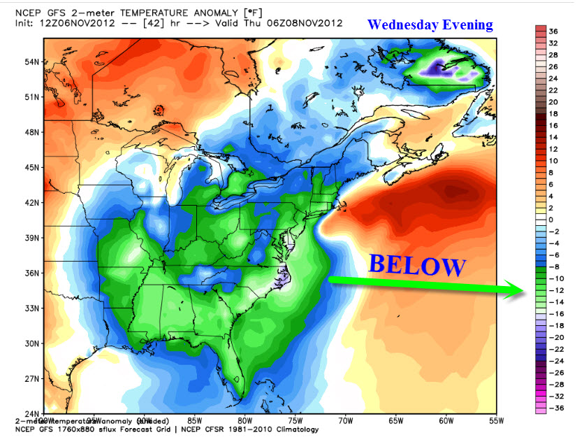
Here are the temperature departures for Wednesday evening and then Sunday - notice how much below normal we will be on Wednesday? Then notice how much above normal we will be on Sunday?
We will warm up later this week because of a strong cold front and area of low pressure over the Central United States. Ahead of these systems we typically warm up - remember that an area of low pressure rotates counter-clockwise. That means warm/moist air is PULLED northward - ahead of the cold front.
Wednesday temperature anomalies - click image for full size view. We will have some clouds around tomorrow - Wednesday. Thus the below normal temperatures. That and the big storm on the east coast will be pulling cooler air down from the north. That low will be along the East Coast - thus the counter-clockwise rotation will put us on the cold side of the storm.

Sunday temperature anomalies - click image for full size

Notice the temperature swings for the coming weekend into early next week
Warm ahead of the cold front - cooling down behind the front! Typical fall pattern.
First image is for Saturday - then Sunday and Monday


Wind: Southeast winds at 5 mph
Precipitation probability - 0% | Rainfall totals: 0"
Confidence in this forecast is high
Friday Partly sunny and warmer.
Highs: in the middle 60s
Wind: Southeast winds at 10-20 mph
Precipitation probability - 0% | Rainfall totals: 0"
Confidence in this forecast is high
Forecast for your local town/city - Click Here
HEADLINES: Hello everyone! Hope you are ready for some "calm" weather? At least it will be calm for our region - areas of the Northeast will once again have to deal with yet another storm system. It will be a long/slow recovery for damaged areas along the coastline.
For our region - we will mostly be in-between storm systems. One exiting to the east, which could bring a few showers tonight (Tuesday night) and Wednesday morning and the other system well off to our west. Chances are small for rain at any given area tonight into Wednesday. Rainfall amounts would be on the light side.
We will start to warm up on Thursday and Friday - ahead of the next storm system. We may see temperatures near 70 on Saturday and Sunday. If it warms up this time of the year then you can expect rain or storms. That will be the case this time around.
A cold front will enter our area on Sunday night and Monday - showers and thunderstorm chances will increase dramatically with the front. It appears that a line of showers and thunderstorms will move from west to east across our region on Sunday night into Monday - severe weather threat appears low/minimal. Perhaps some lightning and gusty winds. I will monitor for any changes in that part of the forecast - instability appears limited.
Rainfall amounts with the weekend system should be in the 0.25-0.60" range.
Temperatures will be colder behind the cold front Monday night into Tuesday. We may see some 20s on Monday night.
Here is what the NAM is showing for Saturday - notice the TIGHT isobars - lines packed together near our region. You can see the area of low pressure over the Rockies - those tight isobars (equal lines of barometric pressure) mean a windy weekend in store for our region - Saturday and Sunday will be windy - gusts above 20-30 mph will be possible (from the south).
This is the system that will bring rain to our region by Sunday night/Monday
Image from wright-weather.com - click image for larger view

The GFS model shows the storm system approaching our region on Sunday - Sunday night - moving through on Monday - completely clear of the region by Monday evening
Remember that the pink/purple/blue area represents precipitation - rain/storms.
Time stamp at top right of each image - click image for larger view - images from wright-weather.com


Here are the temperature departures for Wednesday evening and then Sunday - notice how much below normal we will be on Wednesday? Then notice how much above normal we will be on Sunday?
We will warm up later this week because of a strong cold front and area of low pressure over the Central United States. Ahead of these systems we typically warm up - remember that an area of low pressure rotates counter-clockwise. That means warm/moist air is PULLED northward - ahead of the cold front.
Wednesday temperature anomalies - click image for full size view. We will have some clouds around tomorrow - Wednesday. Thus the below normal temperatures. That and the big storm on the east coast will be pulling cooler air down from the north. That low will be along the East Coast - thus the counter-clockwise rotation will put us on the cold side of the storm.
Sunday temperature anomalies - click image for full size

Notice the temperature swings for the coming weekend into early next week
Warm ahead of the cold front - cooling down behind the front! Typical fall pattern.
First image is for Saturday - then Sunday and Monday


No major concerns

No

No wild cards in this forecast package
.

.
Forecast for your local town/city - Click Here
We have a TON of new weather maps on the Weather Observatory web-site - these include temperatures, wind speed, dew points, heat index, barometric pressure, predicted rainfall, climate forecast, medium and long range maps, forecasts and more! Click here
Don't forget to sign up for the severe weather "heads up" email list - I usually email everyone before a big event - severe weather - tornado outbreaks - winter storms - ice storms. Click here to join
.
---

The forecast for severe or extreme weather
.
The McCracken County Office of Emergency Management reminds you that owning a NOAA All Hazards Weather Radio is the best way to receive notifications of severe weather watches and warnings.
.
Remember that the National Weather Service defines a severe thunderstorm as one that produces 58 mph winds or higher, hail 1" in size or larger, and/or a tornado.
Wednesday: Severe weather is not anticipated. No snow or ice.
Is there a chance for thunderstorms BELOW severe limits No
Thursday: Severe weather is not anticipated. No snow or ice.
Is there a chance for thunderstorms BELOW severe limits? No
Friday : Severe weather is not anticipated. No snow or ice.
Is there a chance for thunderstorms BELOW severe limits? No
.
For the most up to date severe weather outlooks - click here.
For the most up to date severe weather outlooks - click here.
or
Visit the Storm Prediction Center's web-site - click here
To view storm reports from today and yesterday - click here
.
 .
.
Will the Storm Prediction Center issue a tornado or severe thunderstorm watch for southeast Missouri, southern Illinois, or western Kentucky?
To view storm reports from today and yesterday - click here
.
Will the Storm Prediction Center issue a tornado or severe thunderstorm watch for southeast Missouri, southern Illinois, or western Kentucky?
Wednesday - No
Thursday - No
Friday - No
To view the official Storm Prediction Center's web-site - click here Alternative link - click here
Thursday - No
Friday - No
To view the official Storm Prediction Center's web-site - click here Alternative link - click here

.
To view all watches and warnings in IL - Click Here
To view all watches and warnings in KY - Click Here
To view all watches and warnings in MO - Click Here
To view all watches and warnings in TN - Click Here
All other states- Click Here
To view all watches and warnings in IL - Click Here
To view all watches and warnings in KY - Click Here
To view all watches and warnings in MO - Click Here
To view all watches and warnings in TN - Click Here
All other states- Click Here
.
The
links above are interactive and
you can move
around the United States by
simply clicking on the
national map - or
from the pull down menu
where it says regions and
US States.
.
To view the interactive warning map - click here.
.
 .
.
You can listen to local emergency services, SKYWARN storm spotters, and more by visiting our scanner feed page - click here
.
 .
.
The Weather Observatory is a strong partner with the National Weather Service - click here to visit your local NWS web-site. For the most up to date warnings/advisories hit refresh on their page.
 .
.
We have a number of new radars available on our Weather Observatory web-site !
---
We now offer St Louis, Mt Vernon, Evansville, Poplar Bluff, Cape Girardeau, Marion, Paducah, Hopkinsville, Memphis, Nashville, and Dyersburg Interactive City Radars. I have added all of eastern Kentucky, as well.
We also have the two regional radars and now offer you three GR Earth radars.
Click here for our radar page - WEATHER RADARS ---
---
We also have a new interactive radar - you can view that radar by clicking here.
.
To view the interactive warning map - click here.
.
You can listen to local emergency services, SKYWARN storm spotters, and more by visiting our scanner feed page - click here
.
The Weather Observatory is a strong partner with the National Weather Service - click here to visit your local NWS web-site. For the most up to date warnings/advisories hit refresh on their page.
. We have a number of new radars available on our Weather Observatory web-site !
---
We now offer St Louis, Mt Vernon, Evansville, Poplar Bluff, Cape Girardeau, Marion, Paducah, Hopkinsville, Memphis, Nashville, and Dyersburg Interactive City Radars. I have added all of eastern Kentucky, as well.
We also have the two regional radars and now offer you three GR Earth radars.
Click here for our radar page - WEATHER RADARS ---
---
We also have a new interactive radar - you can view that radar by clicking here.
.
Want to learn more about how to use our radars? I made a how to video with more information
Click here - http://www.youtube.com/watch?v=bfLa0hI3adU
.
.
-----------------------------
.

.
Let's
check
out the how much rain is
forecast to fall in our
region. This map gives
you a general
broad brushed idea of
what can be
expected. Remember the scale is at the top of the map.
Click the link below - then choose your the time period you are interested in!
CLICK HERE FOR THE RAINFALL GRAPHIC - then choose the time frame above the image
Click the link below - then choose your the time period you are interested in!
CLICK HERE FOR THE RAINFALL GRAPHIC - then choose the time frame above the image

.
You can also now view the probability of X amount of rain (you pick the value on the web-site) in a six hour period of time. Those maps can be viewed here.
.

Current conditions - including temperatures, apparent temperatures, heat index, wind chill, wind, pressure, humidity, dew points, and more - click here
.
You can also now view the probability of X amount of rain (you pick the value on the web-site) in a six hour period of time. Those maps can be viewed here.
.
Current conditions - including temperatures, apparent temperatures, heat index, wind chill, wind, pressure, humidity, dew points, and more - click here
.

.
You can view the upcoming days high temperature and low temperature forecasts by clicking here - choose the day - click on your state to zoom in
.
To view recent records that have been broken - click here
.
.
You can view the upcoming days high temperature and low temperature forecasts by clicking here - choose the day - click on your state to zoom in
.
To view recent records that have been broken - click here
.
.
---

1. We will watch for another rain maker around November 16th-19th.
Latest drought information:
DROUGHT INFORMATION - CLICK HERE
Seasonal outlooks can be viewed on the web-site - click here
If you are a weather enthusiast then I recommend listening to WeatherBrains each week! For a more in-depth look at what is happening in meteorology.

Now is a GREAT
time to buy a NOAA All Hazards
Weather Radio. Better to have one
before storms
strike than to be without one
during an event. I recommend the
Midland Model 300 NOAA All Hazards Weather Radio - that is what I use here at my house!
.
Meteorologist Beau DodsonMcCracken County Office of Emergency Management
.
.
Beau Dodson Weather - Facebook
.

To view all watches and warnings in Illinois - Click Here
To view all watches and warnings in Kentucky - Click Here
To view all watches and warnings in Missouri - Click Here
To view all watches and warnings in Tennessee - Click Here
.
All other states- Click Here
.
For the latest watches and warnings please visit your local National Weather Service Office web-site.
http://www.weather.gov/organization.php
.
Remember most of the maps on the blog can be viewed on Weather Observatory Web-Site
.

.
No comments:
Post a Comment